
Where Flight Simulation Enthusiasts Gather from Around the World!
AVSIM Library - Search Results

| Category: Flight Simulator 2004 - Scenery | |
| Blaise Diagne International Airport (GOBD/DSS) V1 |

|
Images related to this file:
File Description:
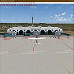
This is Blaise Diagne International Airport (GOBD/DSS), It is the main International Airport of the Republic of Senegal. Located in the town of Diass, it replaces Leopold Sedar Senghor International as the main airport. Built using Sketchup, AFLT, ADE v1.78, sbuilderFS9. Needs RWY12 object library installed for airport objects to show up. You can find RWY12 object library on Avsim/flightsim.
| Filename: | Blaise_Diagne_International_Airport_GOBDDSS_V1.zip |
| License: | Freeware |
| Added: | 2nd December 2021, 02:12:03 |
| Downloads: | 623 |
| Author: | Emmanuel Mwandosya |
| Size: | 22 MB |
| Category: Flight Simulator 2004 - Scenery | |
| HKJK - Jomo Kenyatta Intl. Airport , Nairobi, Africa |
|
File Description:
Nice and simple scenery for Jomo Kenyatta Airport, the airport is located in Nairobi the capital of Kenya. The former
name of the airport was Embakasi Airport, then named Jomo Kenyatta after the first Kenyan prime minister and president
(Jomo Kenyatta). Nairobi Intl. Airport is the 7th busiest airport in Africa and the main hub of Kenya Airways and Five-Forty
Aviation.
| Filename: | HKJK___Jomo_Kenyatta_Intl_Airport__Nairobi_Africa.zip |
| License: | Freeware |
| Added: | 20th July 2008, 15:31:11 |
| Downloads: | 7,950 |
| Author: | Nuhaid Abdulkhaleq |
| Size: | 838.07 KB |
| Category: Flight Simulator 2004 - Scenery | |
| Nimpo Lake CF05 in British Columbia, Canada |
|
Images related to this file:
File Description:
Nimpo Lake is less than 10 miles south of Anahim Lake, and is a centre for fishing lodges and other "nature" activities such as hiking and hunting etc. As a result there is considerable float plane activity on the lake as clients are flown in, or out, to other lakes that are nearby, or just on sightseeing jaunts. This one, CF05, is the second of a trio of Nimpo Lake float bases, the one that is close to the "official" CAF8. It is for Stewart's Lodge fishing centre and Tweedmuir Aviation, both of which are included in this posting. The AI Beavers that are based at the CF05 dock in the AI have a colour scheme that is close to that of Tweedmuir. The AI was included in the posting of CAF8, as were the AI Beavers.
| Filename: | Nimpo_Lake_CF05_in_British_Columbia_Canada.zip |
| License: | Freeware, limited distribution |
| Added: | 2nd December 2018, 17:19:19 |
| Downloads: | 84 |
| Author: | Roger Wensley |
| Size: | 2.84 MB |
| Category: Flight Simulator 2004 - Scenery | |
| 12VA Hop Along - Clifton Forge, Va |
|
File Description:
Hop Along is located near Clifton Forge, Virginia. Flightsim represents it as in reality,
pretty much what it is, a 2150 foot privately owned grass airstrip. According to airnav.com (a
Great source of information, by the way) 12va is 1060 ft. / 323 m (estimated) above sea level
and about 3 miles SE of CLIFTON FORGE, VA. It also indicates that it is a turf runway that is
"rolling and rough" (somthing that the simulator does not present.) While there are no
published photos of this strip, owned by a Mr Wm E. Boyd, The "Hop Along" I created for this
default enhancement contains a bit of this and a bit of that, to give it a bit of what I hope
is "life" making it a fun place to drop in for a visit.
questions or comments ... [email protected]
| Filename: | 12VA_Hop_Along__Clifton_Forge_Va.zip |
| License: | Freeware |
| Added: | 23rd August 2005, 15:29:56 |
| Downloads: | 965 |
| Author: | Dale Caruso |
| Size: | 477.86 KB |
| Category: Flight Simulator 2004 - Scenery | |
| Nimpo Lake CF04 and CF51 in British Columbia, Canada |
|
Images related to this file:
File Description:
Nimpo Lake is less than 10 miles south of Anahim Lake, and is a centre for fishing lodges and other "nature" activities such as hiking and hunting etc. As a result there is considerable float plane activity on the lake as clients are flown in, or out, to other lakes that are nearby, or just on sightseeing jaunts. This one, CF04, is the last of a trio of Nimpo Lake float bases, and is at the far end of the lake from the other two. It is for Nimpo Lake Resort, a lodge and cottages to accommodate anglers and hikers etc. To the south of the lake, and included here, is what I have called Nimpo Lake Land CF51. It cannot by any stretch of imagination be called an airfield, but it is a cleared area and it has been used by wheeled planes. There is no runway as such and it is somewhat bumpy. The AI and the Beavers were included in the posting of CAF8.
| Filename: | Nimpo_Lake_CF04_and_CF51_in_British_Columbia_Canad.zip |
| License: | Freeware, limited distribution |
| Added: | 2nd December 2018, 17:19:32 |
| Downloads: | 93 |
| Author: | Roger Wensley |
| Size: | 3.89 MB |
| Category: Flight Simulator 2004 - Scenery | |
| Wake Island (PWAK) |
|
Images related to this file:
File Description:

FS2004 photo scenery and AI package for Wake Island (PWAK) in the Pacific. Seemingly drifting in a strategic yet isolated position Wake Island-an atoll really-was one of the loneliest outposts of the United States. Originally a gas station for Pan Am's 'Clipper' flying boats, Wake was also a strategic air base during the Second World War. This continued with the Cold War as Wake became a centerpiece of the Pacific Radar Net against the Soviets.
With the thawing of Eastern Europe and the advent of more efficient jet aircraft Wake slowly drifted back to the quiet backwater it is again today, home to a handful of civilian caretakers and local wildlife. This scenery attempt to recapture Wake in the early 1980's when it still performed a semi-regular duty as gas station and pit stop. (This is a reload of the scenery due to the Hack attack - no changes to previous package)
| Filename: | Wake_Island_PWAK.zip |
| License: | Freeware, limited distribution |
| Added: | 15th May 2010, 08:57:58 |
| Downloads: | 4,931 |
| Author: | John Stinstrom |
| Size: | 4.75 MB |
| Category: Flight Simulator 2004 - Scenery | |
| PACD - Cold Bay - Aleutian Islands, Alaska, USA |
|
Images related to this file:
File Description:
Cold Bay is in the eastern third of the Aleutian chain of islands in Alaska, around 175 miles east of Dutch Harbor. The small town has a population of just over 100 and is in existance solely because of the airport with its long runways, one just over 6,000 feet and the other over 10,000 feet and with an ILS. Goods are flown here for local redistribution. The airport was originally built to this size for use in WW2 and there are still quonset huts from this time visible in the area, though the majority of the rough-and-ready housing has now been cleared away. There are scheduled flights by Grant Aviation to neighbouring local airfields and flights to and from Anchorage by Peninsula Air (included in the AI posted with Adak) and Grant Aviation have space attached to their hangar that serves as a terminal. The Coastguard also make use of Cold Bay.
| Filename: | PACD__Cold_Bay___Aleutian_Islands_Alaska_USA.zip |
| License: | Freeware, limited distribution |
| Added: | 21st January 2015, 10:01:50 |
| Downloads: | 423 |
| Author: | Roger Wensley |
| Size: | 4.88 MB |
| Category: Flight Simulator 2004 - Scenery | |
| Northbrook East CF47 and Northbrook West CF48, Ontario, Canada |
|
File Description:
Thirty five miles north of the 401 on Highway 41 is a small town called Northbrook, and in the town itself is a dirt strip with a runway 11/29 1,830 feet long, which for the sake of telling them apart I have called Northbrook East. I have no idea of the history, or even of the reason why. Less than a mile west of the town is a second dirt strip with a runway 04/22 2,200 feet long. This one (Northbrook West) was built to support construction of the electrical power line installation and there is a dirt clearing between the strip and the power lines. There is absolutely nothing at either of these fields, no fuel, no oil, no hangar, and a very rough surface. Although I have made these as grass strips in fact they are dirt; the reason I didn't make them dirt is that dirt in FS9 stands out for miles and looks awful.
| Filename: | Northbrook_East_CF47_and_Northbrook_West_CF48_Onta.zip |
| License: | Freeware |
| Added: | 6th February 2010, 02:36:22 |
| Downloads: | 271 |
| Author: | Roger Wensley |
| Size: | 192.25 KB |
| Category: Flight Simulator 2004 - Scenery | |
| Kangirsuk CYAS in Quebec Canada |
|
Images related to this file:
File Description:
Kangirsuk is an Inuit village in northern Quebec, on the coast of Ungava Bay. The airport is the only means of access on this coast for the population of around 550, apart from a period in late summer. It is between Quaqtaq and Aupaluk, and around 140 miles north of Kuujjuaq, a major centre in this area for supplies, medical care, education, and anything to do with local government. This version of the airport and village is from around 2010, with the original terminal building that has now been replaced. The runway is just under 3,500 feet of lit gravel aligned 04-22 and the AI includes the daily Air Inuit flight that connects Kangirsuk with Kuujjuaq and other local airfields en route. This is almost certainly the last of the northern Quebec coastal airfields that I will be able to model with the correct buildings; only two missing so not too bad.
| Filename: | Kangirsuk_CYAS_in_Quebec_Canada.zip |
| License: | Freeware, limited distribution |
| Added: | 27th August 2020, 17:41:07 |
| Downloads: | 84 |
| Author: | Roger Wensley |
| Size: | 5.67 MB |
| Category: Flight Simulator 2004 - Scenery | |
| Aklavik CYKD in the Northwest Territories, Canada Revised |
|
Images related to this file:
File Description:
This version of Aklavik replaces the previous version so delete all previous installation elements. There is also for Inuvik replacement AI, additional texture, and replacement scenery bgl; this presumes you have already installed my revised post of Inuvik. There is also for Tuktoyuktak additional textures, and replacement scenery bgl's; this presumes you have already installed my 2012 post of Tuktoyakyuk.
Aklavik is a town of 650 or so inhabitants 120 miles inside the Arctic Circle and on the West Channel of the Mackenzie River delta. It is 40 miles west of Inuvik. There are two airlines serving the town on a regular basis and one is Aklak Air, operated by Kenn Borek. Aklavik village has not been changed since my previous post, but the airfield now has the correct terminal building.
The Inuvik replacement AI involves flights to Aklavik and Tuktoyaktuk and the texture and replacement bgl's are for gates that I forgot to include before.
The Tuktoyaktuk scenery now has a barge carrying the prefabricated new terminal for Grise Fiord, plus other items for the installation work. Northern terminals are prefabricated and delivered either complete or in flat-pack form to reduce construction time on site to a minimum. There is a note explaining why the terminal building is on a barge instead of being installed at its destination!
| Filename: | Aklavik_CYKD_in_the_Northwest_Territories_Canada_R.zip |
| License: | Freeware |
| Added: | 14th May 2012, 17:20:39 |
| Downloads: | 537 |
| Author: | Roger Wensley |
| Size: | 8.6 MB |
© 2001-2026 AVSIM Online
All Rights Reserved
Privacy Policy |