
Where Flight Simulation Enthusiasts Gather from Around the World!
AVSIM Library - Search Results

| Category: Flight Simulator 2004 - Scenery | |
| Italy, Toscana 1, Grosseto, Photo Real |

|
Images related to this file:
File Description:
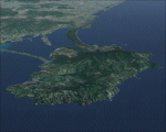
Toscana, Italy, Photoreal Scenery Part 1 (Grosseto).
The photoreal scenery covers a great area of Toscana (Tuscany) around the city of Grosseto. The airport of Grosseto(ICAO code LIRS) are found inside the scenery (see map). For the best results, use it in association with other parts of Toscana photoreal: Toscana 2 Piombino, Toscana 3 Siena, Toscana 4 Poggibonsi, Toscana 5 Livorno_Lucca_Pisa_Pistoia,Toscana 6 Firenze, Toscana 7 Massa_Carrara, italy_islands_vfr_part2_nw.zip
| Filename: | Italy_Toscana_1_Grosseto_Photo_Real.zip |
| License: | Freeware |
| Added: | 27th May 2010, 20:42:50 |
| Downloads: | 6,657 |
| Author: | Fulvio Mazzokan |
| Size: | 69.17 MB |
| Category: Flight Simulator 2004 - Scenery | |
| Italy, Campania 4, Benevento, Photo Real |
|
Images related to this file:
File Description:

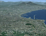
Campania, Italy, Photoreal Scenery Part 4 Benevento.
The photoreal scenery covers a great area of Campania around the city of Benevento (see map). The airports of Napoli (ICAO code LINR) and Grazzanise (LIRM) are founds near the scenery (see map). For the best results, use it in association with other parts of Campania photoreal: Campania 1 Caserta, Campania 2 Napoli, Campania 3 San Severo, Campania 5 Melfi, Campania 6 Palinuro.
| Filename: | Italy_Campania_4_Benevento_Photo_Real.zip |
| License: | Freeware |
| Added: | 31st May 2010, 13:52:07 |
| Downloads: | 6,498 |
| Author: | Fulvio Mazzokan |
| Size: | 75.32 MB |
| Category: Flight Simulator 2004 - Scenery | |
| Italy, Campania 2, Naples (Napoli), Photo Real |
|
Images related to this file:
File Description:
Campania, Italy, Photoreal Scenery Part 2 Naples (Napoli).
The photoreal scenery covers a great area of Campania around the city of Naples (Napoli). The airports of Napoli (ICAO code LINR) and Pontecagnano (LIRI) are founds inside the scenery (see map). For the best results, use it in association with other parts of Campania photoreal: Campania 1 Caserta, Campania 3 San Severo, Campania 4 Benevento, Campania 5 Melfi, Campania 6 Palinuro.
| Filename: | Italy_Campania_2_Naples_Napoli_Photo_Real.zip |
| License: | Freeware |
| Added: | 31st May 2010, 17:41:08 |
| Downloads: | 9,681 |
| Author: | Fulvio Mazzokan |
| Size: | 75.74 MB |
| Category: Flight Simulator 2004 - Scenery | |
| Exploring Our World - Part 1. Canaima Park - Canaima Airport (SCVN) - Angel Falls, Venezuela |
|
Images related to this file:
File Description:

Exploring Our World - Part 1. Canaima Park - Canaima Airport (SCVN) - Angel Falls, Venezuela. Visit the worlds highest waterfall (16 times higher than Niagara) - one of the Natural Wonders of the World!
This new package features David Maldonado's excellent Mesh of Canaima Park in Venezuela and a very special "animated" depiction of Angel Falls by Ron Jeffers. The Canaima Airport has been enhanced using EZ Scenery libraries. There is also an optional Lago sound file created by Lou Frost. A brief history of Angel Falls along with a suggested tour of the area is included. You will also find a flight plan for use with the FSNavigator program. This is the first of a projected series exploring lesser known parts of our FS world. Please unzip (using folders option) to a temporary folder and follow the instructions very carefully.
This project was compiled for your flying enjoyment by David "Opa" Marshall.
| Filename: | Exploring_Our_World__Part_1_Canaima_Park__Canaima_.zip |
| License: | Freeware |
| Added: | 31st October 2009, 10:36:18 |
| Downloads: | 3,254 |
| Author: | David "Opa" Marshall |
| Size: | 3.22 MB |
| Category: Flight Simulator 2004 - Scenery | |
| California Central Coast Scenery with Ultimate Terrain USA |
|
File Description:
This is a complete revision to California Central Coast Scenery CCCOASTU.ZIP that was uploaded 9/13/05. This revision involves most of the files and replaces CCCOASTU.ZIP in it's entirety so the original version of CCCOASTU and it's Revisions 1 and 2 or any other versions of my CCC scenery are NOT required.
The primary goal for this revision was to replace as many API objects and effects as possible with XML/MDL library objects. The original intent for making these conversions was to begin to prepare for the FSX version of CCC scenery if that becomes practical. Because I also made several improvements and fixes during that process and because performance was improved due to use of object libraries I realized it might be appropriate to upload the results as a revision.
| Filename: | California_Central_Coast_Scenery_with_Ultimate_Ter.zip |
| License: | Freeware |
| Added: | 19th April 2006, 04:31:54 |
| Downloads: | 4,896 |
| Author: | Al Wheeler |
| Size: | 5.96 MB |
| Category: Flight Simulator 2004 - Scenery | |
| Homer Airport PAHO |
|
Images related to this file:
File Description:
FS2004 Scenery - Homer Airport (IATA: HOM, ICAO: PAHO, FAA LID: HOM) is a state-owned public-use airport located two nautical miles (4 km) east of the central business district of Homer, a town in the Kenai Peninsula Borough of the U.S. state of Alaska.
Homer Airport covers an area of 1,040 acres (421 ha) at an elevation of 84 feet (26 m) above mean sea level. It has one runway designated 3/21 with a 6,701 x 150 ft (2,042 x 46 m) asphalt pavement, and a facility for floatplanes on nearby Beluga Lake (5BL). This package consists of PAHO only. By John B. Loney, Jr.
| Filename: | Homer_Airport_PAHO.zip |
| License: | Freeware, limited distribution |
| Added: | 21st December 2010, 04:21:22 |
| Downloads: | 1,675 |
| Author: | John B. Loney, Jr. |
| Size: | 7.73 MB |
| Category: Flight Simulator 2004 - Scenery | |
| Burns Lake CYPZ in British Columbia, Canada |
|
Images related to this file:
File Description:
Burns Lake is 90 miles east of Terrace and 130 miles west of Prince George, on the eastern side of the Coast Mountains. The airfield is at 2343' ASL and the 11/29 runway is just over 7,000' of 75' wide asphalt. There are buildings, some of them new, around the apron at the west end of the runway and both JetA and 1100LL are available. There is also a weather station in a fenced area west of the apron. All apron buildings were modeled specifically for this scenery; there may be some missing if new construction has continued in the last three years.
| Filename: | Burns_Lake_CYPZ_in_British_Columbia_Canada.zip |
| License: | Freeware, limited distribution |
| Added: | 11th May 2011, 16:57:44 |
| Downloads: | 465 |
| Author: | Roger Wensley |
| Size: | 4.57 MB |
| Category: Flight Simulator 2004 - Scenery | |
| Bethel PABE in southwest Alaska |
|
Images related to this file:
File Description:
There are four main northwestern Alaska towns which have good airports and are serviced by Alaska Airlines. From these airports local flights connect to nearby villages, "nearby" in Alaska meaning up to 200 miles away. The northernmost is Barrow. Southwest of Barrow is Kotzebue, then Nome, and the furthest south is this one, Bethel. The town of Bethel has a population of just over 6,000 and is 50 miles from the sea on the Kuskowim River, that splits and forks into many tributaries. Bethel Airport is close to the town and provides the only contact with the rest of Alaska, as there is no connecting highway system. There are scheduled flights by Alaska Airlines, ERA (now called Ravn) and Grant Aviation, plus others such as Ryan Air. There are cargo flights by Everts, Northern, and Lynden, and redistribution onwards to nearby villages by the smaller locally-based planes; all of these are included in the AI. There are two main runways, one just under 6,400 feet and another just under 3,900 feet, both of them aligned 19-1. The third runway is around 1,800 feet and mainly gravel, aligned 11-29. Parking at PABE is on three aprons, the northern for smaller commercial planes of Grant, ERA, Ryan etc, the central for larger planes of Alaska, Northern, Everts, and Lynden, and the southern for a large collection of GA; each apron has further hangars for maintenance companies and smaller operators. There is also another separate apron for the local military and Coastguard. There is not much photographic information available for PABE, and I have never been there; as a result it was impossible to make detailed photographic textures for some of the buildings. However, for most hangars I have made textures of at least the right colour etc based on the information I assembled and if it is green with white trim and side windows then that is how it now appears here. The exceptions are the Alaska Airlines terminal building which has complicated curved elements, and the two military hangars and workshops where I had to settle for an Alaska terminal building from another airport and the same for the military. There are numerous small villages in the vicinity of Bethel, all of them being beside either a river tributary or the coast. There are two Google Earth screenshots to show the villages that are served by the flights from Bethel and that are (mostly) included in the AI. Some of these airfields were not included in FS9 but AI will still operate in and out of Bethel. The smaller area screenshot shows the villages that are close to Bethel, and of these eight I have so far made six and they are included in this post: Napaskiak PKA, Napakiak WNA, Kwethluk KWT, Atmautluak 4A2, Nunapitchuk 16A, and Kasigluk Z09. I will work my way through the rest of the area.
| Filename: | Bethel_PABE_in_southwest_Alaska.zip |
| License: | Freeware, limited distribution |
| Added: | 8th March 2019, 00:37:58 |
| Downloads: | 303 |
| Author: | Roger Wensley |
| Size: | 32.02 MB |
| Category: Flight Simulator 2004 - Scenery | |
| CYYQ - Churchill Port & York Factory - Northern Manitoba, Canada |
|
Images related to this file:
File Description:
The main part of this scenery installs the Port of Churchill and the grain silos. Churchill CYYQ has been made by Sidney Schwartz, and this also adds AI and slightly modifies his parking to make a space big enough for Buffalo's C46. Churchill is in northern Manitoba, on the Churchill River where it empties into Hudson Bay. The town is accesible by air, by boat (once the winter ice melts) and most importantly by rail from the south. Grain from the Canadian prairies is hauled north and stored in Churchill for export to Europe by a sea route that is significantly shorter than any other, and there is a grain carrier included in the AI. Today there are perhaps 810 people living in Churchill, a slowly declining number. There are also a number of impressive polar bears. There was another port south of Churchill, but it was never completed, never connected to a railroad track, and never used. It was called Port Nelson, and was at the mouth of the Nelson River. Nearby, on the Hayes River, there is an old trading post called York Factory, built in 1684 and preserved as part of the living history of the north of Canada. The second scenery is for this, and for the nearby tourist camp called Silver Goose Lodge, which as the name suggests is for hunters. The large grassy area alongside the fort was for the trappers to camp on when they all arrived in early summer to trade the furs for goods.
| Filename: | CYYQ__Churchill_Port__York_Factory__Northern_Manit.zip |
| License: | Freeware, limited distribution |
| Added: | 23rd July 2014, 02:26:04 |
| Downloads: | 542 |
| Author: | Roger Wensley |
| Size: | 3.69 MB |
| Category: Flight Simulator 2004 - Scenery | |
| North Netherlands |
|
File Description:
This is extra addon scenery for the default FS2004 in the northern part of Holland: Dokkum,Eernewoude,Oostwold,Giethoorn,Leek,Groningen and other spots for VFR flying.
| Filename: | North_Netherlands.zip |
| License: | Freeware |
| Added: | 12th August 2003, 16:32:54 |
| Downloads: | 5,619 |
| Author: | Joop Mak |
| Size: | 1.34 MB |
© 2001-2026 AVSIM Online
All Rights Reserved
Privacy Policy |