
Where Flight Simulation Enthusiasts Gather from Around the World!
AVSIM Library - Search Results

| Category: Flight Simulator 2004 - Scenery | |
| Mal Paso Airport (SANE) - Argentina |

|
File Description:
This is very operative airport of Mal Paso (SANE)in Santiago del Estero, Provincia de Santiago del Estero, Republica Argentina, with all navaids and the objects in this correct place. This is not photorealistic scenery.ONLY FOR FS2004. Building with SceneGenX 1.0 Build 57 of Tom Hiscox
and some objects of RWY12.
| Filename: | Mal_Paso_Airport_SANE__Argentina.zip |
| License: | Freeware |
| Added: | 18th June 2006, 20:08:30 |
| Downloads: | 1,479 |
| Author: | carlos maida |
| Size: | 845.68 KB |
| Category: Flight Simulator 2004 - Scenery | |
| Villa Reynolds (SAOR) - Argentina |
|
File Description:
This is very operative airport of Villa Reynolds (SAOR) in San Luis, Provincia de San Luis, Republica Argentina, with all navaids and the objects in this correct place. This is not photorealistic scenery. ONLY FOR FS2004. Building with SceneGenX 1.0 Build 61 of Tom Hiscox and some objects of RWY12.
| Filename: | Villa_Reynolds_SAOR__Argentina.zip |
| License: | Freeware, limited distribution |
| Added: | 26th August 2006, 17:53:58 |
| Downloads: | 1,227 |
| Author: | carlos maida |
| Size: | 499.92 KB |
| Category: Flight Simulator 2004 - Scenery | |
| Santa Cruz - Bolivia, Viru Viru International SLVR / VVI |
|
Images related to this file:
File Description:

Thank you for downloading this scenery. This is a very basic rebuild of Viru Viru Int'l Airport. This airport serves as a major hub for Lloyd Aereo Biolivia and Aerosur. It is also a technical stop for long haul flights out of the more mountainous cities of Bolivia. Most aircraft cannot takeoff from airports like La Paz El Alto with a full load of fuel because of its 13,000ft elevation, and Viru Viru is close to sea level.
This scenery has a rebuilt terminal, jetways, baggage carts, and an AFCAD with added parking. There was very little information available other than sat photos, so it is not perfectly correct or photoreal, but it is a good basic representation.
| Filename: | Santa_Cruz__Bolivia_Viru_Viru_International_SLVR__.zip |
| License: | Freeware |
| Added: | 30th May 2010, 10:30:12 |
| Downloads: | 6,862 |
| Author: | William Morgan, FRFSTUDIO.NET |
| Size: | 1.34 MB |
| Category: Flight Simulator 2004 - Scenery | |
| Mackenzie River close to Tulita CZFN in Northwest Territories Canada |
|
Images related to this file:
File Description:
I discovered, while testing another airfield near the Mackenzie River, that along the side of the Mackenzie adjacent to Tulita, and for a considerable distance, there was a cliff of water. I have no idea if my version of Ultimate Terrain has developed a fault or if this has been caused by the installation of a terrain mesh that now argues with UT for some unknown reason. Whatever, it was impossible to leave it as it was. I have included a screenshot of the cliff further upstream. To avoid the cliff of water I have flattened that area of the Mackenzie River and the adjacent river banks and both the town and the airfield to a height above sea level of 400 feet. This does not reflect the real life situation but is the lesser of two optical evils. I have included a screenshot of the flattened area. If you do not have a problem then you do not need this. If you too have a cliff of water then you might want to try this. It does not completely get rid of the problem, but it does get rid of it in the area visible when landing or taking off at Tulita.
| Filename: | Mackenzie_River_close_to_Tulita_CZFN_in_Northwest_.zip |
| License: | Freeware, limited distribution |
| Added: | 1st August 2021, 22:27:01 |
| Downloads: | 74 |
| Author: | Roger Wensley |
| Size: | 573.48 KB |
| Category: Flight Simulator 2004 - Scenery | |
| KEKM - Elkhart Municipal Airport - Elkhart, Indiana |
|
Images related to this file:
File Description:
FS2004 Scenery - Elkhart Municipal Airport serves Elkhart and Elkhart County and is owned by the City Of Elkhart, Indiana. The airport has more than one runway. The longest is a paved runway extending 6500 feet. The facility is at an elevation of 778 feet at a distance of about 3 miles from Elkhart. For the enjoyment of the FS community, by John B. Loney, Jr.
| Filename: | KEKM__Elkhart_Municipal_Airport__Elkhart_Indiana.zip |
| License: | Freeware, limited distribution |
| Added: | 22nd March 2013, 19:02:41 |
| Downloads: | 386 |
| Author: | John B. Loney, Jr. |
| Size: | 77.88 MB |
| Category: Flight Simulator 2004 - Scenery | |
| Italy, Lazio 3, Rieti, Photo Real |
|
Images related to this file:
File Description:
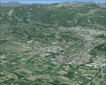
Lazio, Italy, Photoreal Scenery Part 3 (Rieti).
The photoreal scenery covers a great area of Lazio around the city of Rieti. The airports of Rieti (ICAO code LIQN) and Guidonia (LIRG) are founds inside the scenery (see map). For the best results, use it in association with other parts of Lazio photoreal: Lazio 1 Viterbo, Lazio 2 Roma, Lazio 4 Latina, Lazio 5 Gaeta.
| Filename: | Italy_Lazio_3_Rieti_Photo_Real.zip |
| License: | Freeware |
| Added: | 31st May 2010, 17:44:14 |
| Downloads: | 7,989 |
| Author: | Fulvio Mazzokan |
| Size: | 90.99 MB |
| Category: Flight Simulator 2004 - Scenery | |
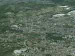
| Italy, Lazio 4, Latina, Photo Real |
|
Images related to this file:
File Description:
Lazio, Italy, Photoreal Scenery Part4 (Latina). The photoreal scenery covers a great area of Lazio around the city of Latina. The airports of Pratica di mare (ICAO code LIRE) Latina (LIRL) and Frosinone (LIRH) are founds inside the scenery (see map). For the best results, use it in association with other parts of Lazio photoreal: Lazio 1 Viterbo, Lazio 2 Roma, Lazio 3 Rieti, Lazio 4 Gaeta.
| Filename: | Italy_Lazio_4_Latina_Photo_Real.zip |
| License: | Freeware |
| Added: | 31st May 2010, 11:42:16 |
| Downloads: | 8,809 |
| Author: | Fulvio Mazzokan |
| Size: | 73.9 MB |
| Category: Flight Simulator 2004 - Scenery | |
| Flugplatz Bitburg Verson 3 |
|
File Description:
Bitburg lies among the hills of the of the Eiffel about 50 km north of Trier, Compared to most Air force Bases Bitburg is quite small, but for its entire existence it was the best assignment in the Air Force. Bitburgs punch came from the 36 Fighter Wing and its 3 Squadrons of F15 Eagles, the 525th, (Bulldogs) Big 22, (Stingers) and the 53rd (Tigers).
| Filename: | Flugplatz_Bitburg_Verson_3.zip |
| License: | Freeware |
| Added: | 25th November 2008, 00:21:14 |
| Downloads: | 1,969 |
| Author: | Michael Wood |
| Size: | 202.08 KB |
| Category: Flight Simulator 2004 - Scenery | |
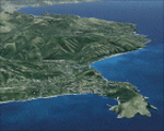
| Italy, Campania 1, Caserta, Photo Real |
|
Images related to this file:
File Description:
Campania, Italy, Photoreal Scenery Part 1 (Caserta). The photoreal scenery covers a great area of Campania around the city of Caserta. The airport of Grazzanise (ICAO code LIRM) are found inside the scenery (see map). For the best results, use it in association with other parts of Campania photoreal: Campania 2 Napoli, Campania 3 San Severo, Campania 4 Benevento, Campania 5 Melfi, Campania 6 Palinuro.
| Filename: | Italy_Campania_1_Caserta_Photo_Real.zip |
| License: | Freeware |
| Added: | 31st May 2010, 09:14:05 |
| Downloads: | 7,912 |
| Author: | Fulvio Mazzokan |
| Size: | 95.08 MB |
| Category: Flight Simulator 2004 - Scenery | |
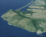
| Italy, Campania 6, Palinuro, Photo Real |
|
Images related to this file:
File Description:
Campania, Italy, Photoreal Scenery Part 6 (Palinuro).
The photoreal scenery covers a great area of Campania around the city of Palinuro. The airport of Pontecagnano (ICAO code LIRI) is found near the scenery (see map). For the best results, use it in association with other parts of Campania photoreal: Campania 1 Caserta, Campania 2 Napoli, Campania 3 San Severo, Campania 4 Benevento, Campania 5 Melfi.
| Filename: | Italy_Campania_6_Palinuro_Photo_Real.zip |
| License: | Freeware |
| Added: | 31st May 2010, 14:40:59 |
| Downloads: | 6,382 |
| Author: | Fulvio Mazzokan |
| Size: | 90.55 MB |
© 2001-2026 AVSIM Online
All Rights Reserved
Privacy Policy |