
Where Flight Simulation Enthusiasts Gather from Around the World!
AVSIM Library - Search Results

| Category: Flight Simulator 2004 - Scenery | |
| CZFM - Fort McPherson - Northwest Territories, Canada |

|
Images related to this file:
File Description:
This is the first of a series of airfields that follow (approximately) that early access route to the Canadian northern shore, the Mackenzie River. At the far northern end of the river and on the eastern side of the delta there is Tuktoyaktuk, then 80 miles south is Inuvik (both already posted). 70 miles south of Inuvik is Fort McPherson, on the east bank of the Peel River, 20 miles west of the junction with the Mackenzie and on the Dempster Highway. The town has a population of around 830, and (as usual in the north!) was the site of a Hudson Bay trading post, the main post for the Mackenzie delta area for over 50 years. The airport is less than 2 miles to the south of the town, and has 3,500 feet of gravel runway. AI is two ga flights and a Buffalo Airways delivery trip that hops north and south from field to field; this will change with further posts. There is no fuel available.
| Filename: | CZFM__Fort_McPherson__Northwest_Territories_Canada.zip |
| License: | Freeware, limited distribution |
| Added: | 4th July 2014, 05:33:03 |
| Downloads: | 288 |
| Author: | Roger Wensley |
| Size: | 2.3 MB |
| Category: Flight Simulator 2004 - Scenery | |
| St.Gabriel-de-Brandon Airfield, Quénec Bush Scenery |
|
File Description:
St.Gabriel-de-Brandon, is situated North East of Montréal, at the edge of the Laurentian mountains. It is the 'gate' to Québec Bush Flying region. It is part of Québec Short Hops. Though Lago Scenery Enhancer is recommended for sounds and a few objects, this scenery is self supportive. There is a grass strip and float plane facilities with lots of candies.
| Filename: | StGabrieldeBrandon_Airfield_Qunec_Bush_Scenery.zip |
| License: | Freeware |
| Added: | 28th February 2004, 01:44:33 |
| Downloads: | 2,227 |
| Author: | Leon Louis |
| Size: | 5.81 MB |
| Category: Flight Simulator 2004 - Scenery | |
| LGMG v2. Megara airport Athens area, Greece |
|
File Description:
This is a update version of previous "lgmg_haa_ga" scenery, which covers the LGMG airport.
LGMG Megara airport located 40km west of Athens and is the base airport for all General Aviation aircrafts and helicopters. Also at LGMG there are two battalions of Hellinic Army Aviation with UH-1H, CH-47D and C-12(B200).
This scenery requires the previous version of "lgmg_haa_ga"
| Filename: | LGMG_v2_Megara_airport_Athens_area_Greece.zip |
| License: | Freeware |
| Added: | 27th February 2006, 17:23:46 |
| Downloads: | 2,774 |
| Author: | Dimitris Pastarmatzis |
| Size: | 3.87 MB |
| Category: Flight Simulator 2004 - Scenery | |
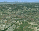
| Italy, Umbria 1, Terni, Photo Real |
|
Images related to this file:
File Description:

Umbria, Italy, Photoreal Scenery Part 1 (Terni).
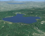
The photoreal scenery covers a great area of Umbria around the city of Terni. The airport of Perugia San Egidio (ICAO code LIRZ) is found near the scenery (see map). For the best results, use it in association with other parts of Umbria photoreal: Umbria 2 Trasimeno, Umbria 3 Perugia, Umbria 4 Arezzo.
| Filename: | Italy_Umbria_1_Terni_Photo_Real.zip |
| License: | Freeware |
| Added: | 27th May 2010, 20:52:07 |
| Downloads: | 5,597 |
| Author: | Fulvio Mazzokan |
| Size: | 71.63 MB |
| Category: Flight Simulator 2004 - Scenery | |
| Italy, Umbria 4, Arezzo, Photo Real |
|
Images related to this file:
File Description:
Umbria, Italy, Photoreal Scenery Part 4 (Arezzo).
The photoreal scenery includes a wide area of Umbria and Tuscany around the city of Arezzo. The airport of Arezzo (ICAO code LIQB) is found inside the scenery (see map). For the best results, use it in association with other parts of Umbria photoreal: Umbria 1 Terni, Umbria 2 Trasimeno, Umbria 3 Perugia.
| Filename: | Italy_Umbria_4_Arezzo_Photo_Real.zip |
| License: | Freeware |
| Added: | 31st May 2010, 12:53:08 |
| Downloads: | 5,300 |
| Author: | Fulvio Mazzokan |
| Size: | 88.3 MB |
| Category: Flight Simulator 2004 - Scenery | |
| Italy, Liguria 3, Imperia, Photo Real |
|
Images related to this file:
File Description:

Liguria, Italy, Photoreal Scenery Part 3 (Imperia).
The photoreal scenery covers a great area of Liguria around the city of Imperia. The airport of Cuneo-Levaldigi (ICAO code LIMZ) is found inside the scenery (see map). For the best results, use it in association with other parts of Liguria photoreal: Liguria 1 La Spezia, Liguria 2 Savona and Genova VFR.
| Filename: | Italy_Liguria_3_Imperia_Photo_Real.zip |
| License: | Freeware |
| Added: | 27th May 2010, 15:02:10 |
| Downloads: | 8,090 |
| Author: | Fulvio Mazzokan |
| Size: | 86.47 MB |
| Category: Flight Simulator 2004 - Scenery | |
| Italy, Liguria 1, La Spezia, Photo Real |
|
File Description:
Liguria, Italy, Photoreal Scenery Part 1 (La Spezia).
The photoreal scenery covers a great area of Liguria around the city of La Spezia. The airport of Luni-Sarzana (ICAO code LIQW) is found inside the scenery (see map). For the best results, use it in association with other parts of Liguria photoreal: Liguria 2 Savona, Liguria 3 Imperia, Genova VFR.
| Filename: | Italy_Liguria_1_La_Spezia_Photo_Real.zip |
| License: | Freeware |
| Added: | 20th October 2008, 02:18:20 |
| Downloads: | 9,312 |
| Author: | Fulvio Mazzokan |
| Size: | 67.03 MB |
| Category: Flight Simulator 2004 - Scenery | |
| Pontile Foceverde |
|
File Description:
Scenario del pontile di Foce verde presso Latina LIRL, interamente in Gmax.Consigliato per l'effetto scenico, anche il mio precedente scenario del castello di Torre Astura e Torre Paola.Scenery of the wharf of Foce Verde near Latin LIRL, completely designed using Gmax.It is advised for the scenic effect, also my previous scenery of the castle of Torre Astura and Torre Paola.
| Filename: | Pontile_Foceverde.zip |
| License: | Freeware, limited distribution |
| Added: | 4th September 2008, 15:50:36 |
| Downloads: | 412 |
| Author: | Claudio "Werwolf" Carra |
| Size: | 342.76 KB |
| Category: Flight Simulator 2004 - Scenery | |
| Italy, Lazio 1, Viterbo, Photo Real |
|
Images related to this file:
File Description:
Lazio, Italy, Photoreal Scenery Part1 (Viterbo). The photoreal scenery covers a great area of Lazio around the city of Viterbo. The airport of Viterbo (ICAO code LIRV) is found inside the scenery (see map). For the best results, use it in association with other parts of Lazio photoreal: Lazio 2 Roma, Lazio 3 Rieti, Lazio 4 Latina, Lazio 5 Gaeta.
| Filename: | Italy_Lazio_1_Viterbo_Photo_Real.zip |
| License: | Freeware |
| Added: | 31st May 2010, 11:44:11 |
| Downloads: | 9,292 |
| Author: | Fulvio Mazzokan |
| Size: | 89.84 MB |
| Category: Flight Simulator 2004 - Scenery | |
| Ontario International Airport (KONT) V2 |
|
Images related to this file:
File Description:
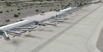
Detailed scenery of Ontario International Airport, California, USA. The airport is one of the major Southern California basin airports feeding travelers into east Los Angeles and beyond.
This is version 2 of the Ontario Airport scenery previously released in 2006 but is a standalone almost complete reconstruction of the scenery and is recommended as a new scenery install. See readme for details.
| Filename: | Ontario_International_Airport_KONT_V2.zip |
| License: | Freeware, limited distribution |
| Added: | 19th May 2012, 17:07:35 |
| Downloads: | 3,834 |
| Author: | Shehryar Ansari |
| Size: | 37.82 MB |
© 2001-2026 AVSIM Online
All Rights Reserved
Privacy Policy |