
Where Flight Simulation Enthusiasts Gather from Around the World!
AVSIM Library - Search Results

| Category: Flight Simulator 2004 - Scenery | |
| Minstrel Island CAX7 float base in British Columbia, Canada |

|
Images related to this file:
File Description:
This is the third in a series of new and renovated float bases in BC. Minstrel Island is on the south side of Knight Inlet and 25 miles west of Knight Inlet Lodge (the previous post in this series). There is a resort on the island, though it is hidden from the air by the trees. Fuel and oil are both available at the dock, and there is a 17 feet tidal range, which would be interesting of it could be replicated in FS. The AI is an adaptation of that for CF36 and involves a GA Cessna, and a Seair Beaver flying from Campbell River to Knight Inlet Lodge via Minstrel Island. Again, because of large hills the landing of the AI may or may not take place, depending on wind direction and whether or not they fly into solid rock before landing. Take off and departure will take place. Ultimate Terrain Alaska/Canada would be a definite plus to get the water in the right shape and place. This scenery will not work without it.
| Filename: | Minstrel_Island_CAX7_float_base_in_British_Columbi.zip |
| License: | Freeware, limited distribution |
| Added: | 3rd January 2017, 15:38:57 |
| Downloads: | 224 |
| Author: | Roger Wensley |
| Size: | 3.54 MB |
| Category: Flight Simulator 2004 - Scenery | |
| Alaska South Slope 4; Selawik PASK |
|
Images related to this file:
File Description:
There are four main northwestern Alaska towns which are serviced by Alaska Airlines, and from which local flights spread out. The northernmost is Barrow. Southwest of Barrow is Kotzebue, then Nome, and the furthest south is Bethel. This series is for the flights from and around Kotzebue, mostly on the South Slope of the Brooks Range of mountains. There will be further additions. Selawik is a village (population now around 760) around 75 miles east of Kotzebue on three of the delta islands of the Selawik River where it flows into Selawik Lake. The delta forms part of the Selawik National Wildlife Refuge for migratory birds. The airfield is just next to the village, with two runways, 3,450 feet of lit gravel aligned 03-21 and 3,100 feet of gravel aligned 09-27. There are scheduled flights by Era (now renamed Ravn) and by Bering Air, both of them originating in Kotzebue and routing east to Noorvik, Kiana, Selawik, etc, and then back again. The AI includes these flights along with Everts Air and GA.
| Filename: | Alaska_South_Slope_4_Selawik_PASK.zip |
| License: | Freeware, limited distribution |
| Added: | 9th October 2016, 04:17:52 |
| Downloads: | 212 |
| Author: | Roger Wensley |
| Size: | 4.34 MB |
| Category: Flight Simulator 2004 - Scenery | |
| Zion National Park South, Hurricane (1L8), Colorado City (KAZC), Utah/Arizona, Photo-Scenery (FS9 & FSX) |
|
Images related to this file:
File Description:
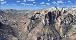
Covers the southern part of Zion National Park extends south along the cities of Hurricane and Colorado City. Zion National Park is another place where erosion of the Colorado Plateau formed the most beautiful colorful stone formations of unique and wonderful shapes. There are nine different layers of stone visible in the park. Most of them consist of sandstone. But there is also limestone, gypsum, siltstone, shale, clay and mudstone. The Virgin River cut a spectacular and famous canyon thru Zion Park that is as narrow as 20ft and up to 2000ft tall.
High resolution versions of this scenery for FS9 and FSX (much sharper, but larger and multiple downloads)
are available at www.blueskyscenery.com/CNY_South3West5.html . The screenies are taken from the high-res versions,
so expect this version to be slightly more blurry. Thanks to Joop Mak for providing custom AFCADs that
correct airport layouts so that they align with the photo-textures! They are available at www.blueskyscenery.com/AFCADs.html . YourDonation@Work: Dedicated to Jerry, Ralph J. and Lance.
| Filename: | Zion_National_Park_South_Hurricane_1L8_Colorado_Ci.zip |
| License: | Freeware, limited distribution |
| Added: | 20th March 2010, 23:26:42 |
| Downloads: | 1,783 |
| Author: | Gottfried Razek - blueskyscenery.com |
| Size: | 95.39 MB |
| Category: Flight Simulator 2004 - Scenery | |
| The Greater Toronto Area Part 1 |
|
File Description:
Part 1 of Flight Ontario's scenery for the Greater Toronto Area and Southern Ontario.
Over a year in the making, this scenery for Fs 2002 and Fs 2004 is bounded by Detroit in the west, Kingston in the east, Huntsville in the north and Buffalo in the south and features:
* all-season scenery
* custom water textures
* completely modelled Toronto Airports...CYTZ (Toronto Island) and CYZD
(Downsview-home to Bombardier Aerospace and the Canadair Regional Jet
and Dash-8, and the Toronto Aerospace Museum)
* custom autogen for the GTA
* Custom landclass for southern Ontario
* custom shorelines (western Lake Ontario, Kingston area, Lake
Couchiching...Severn River...Sparrow Lake area, and the Muskoka Lake
area)
* prominent features around Hamilton include the Burlington Skyway and
Lift Bridge and steel mills
* the Welland Canal is featured with lift bridges, bascule bridge and
fixed link bridge from Pt Weller to Pt Colborne
* the Niagara area includes the Minolta Tower, and 3 hydro generating
plants with reservoirs
* compatibility with SimFlyers CYYZ
This scenery is downloadable in two parts and both parts are essential
| Filename: | The_Greater_Toronto_Area__Part_1.zip |
| License: | Freeware |
| Added: | 9th April 2004, 12:40:02 |
| Downloads: | 37,176 |
| Author: | Flight Ontario |
| Size: | 62.09 MB |
| Category: Flight Simulator 2004 - Scenery | |
| Howick Airfield (FAHC), South Africa |
|
Images related to this file:
File Description:
This package will add a custom (Gmax) made Howick Airfield (FAHC), KwaZulu Natal, South Africa with photoreal textures and seasonal ground textures.
Howick is a small town in the KwaZulu Natal Midlands just off the N3 freeway which connects Johannesburg and Durban and home to the famous Howick waterfall. The Umgeni river falls 95m (311 ft) over the cliffs on the way to the Indian Ocean. The town is also home to the Midmar dam. This dam is very well known as being the location of the annual Midmar Mile swimming event which, in 2009, was recognized by the Guinness Book of World Records as the world's largest open water swimming event with 13 755 competitors taking part.
The sloped grass runway is aligned 16/34 and 825m long and sits at an elevation of 3 615ft. Both runways have obstacles on the approach, with powerlines 730m from the threshold of runway 16, while runway 34's approach have hills around 900m before the threshold. The sloped runway has been created in FS2004 within the limits of the simulator itself.
| Filename: | Howick_Airfield_FAHC_South_Africa.zip |
| License: | Freeware, limited distribution |
| Added: | 15th January 2021, 20:25:51 |
| Downloads: | 201 |
| Author: | Kobus van Wyk |
| Size: | 7.67 MB |
| Category: Flight Simulator 2004 - Scenery | |
| Colombian Airports - Update |
|
File Description:
This is an update to my previous Colombian Airports upload colapts1.zip.
The update contains mainly some navaid corrections to SKFL, SKIB, and SKVP, and adds the airport SKSJ Jorge E. Gonzales of San Jose del Guaviare; this is now at the correct location and altitude and has buildings, objects, and landclass added. It is for FS9 default scenery and the Colombia freeware mesh by Raimondo Taburet. However, the scenery should also work with the default or any other mesh but I have not tested it.
However, please NOTE:
that in the default scenery without mesh the airport SKSJ will be below the rest of the surface whereas with the mesh, the airport will be at the same altitude as the rest of the scenery with the exception of the river which now runs at a higher (the default) altitude (see screenshots). For me flying without the mesh does not make any sense, so I live with that restriction. If you don't like it, you can always delete or deactivate the files starting with "SKSJ".
| Filename: | Colombian_Airports__Update.zip |
| License: | Freeware |
| Added: | 10th September 2014, 14:50:05 |
| Downloads: | 1,437 |
| Author: | Detlev J. Rohmer |
| Size: | 5.4 MB |
| Category: Flight Simulator 2004 - Scenery | |
| Colorado Lakes Project II |
|
File Description:
This project features the Blue Mesa Reservoir and the Black Canyon of the Gunnison and adds over 300 highly detailed lakes to the central portion of western Colorado. Three reservoirs, named for corresponding dams on the Gunnison River, form the heart of Curecanti National Recreation Area. Panoramic mesas, fjord-like reservoirs, and deep, steep and narrow canyons abound. Blue Mesa Reservoir is Colorado's largest body of water, and is the largest Kokanee Salmon fishery in the United States. Morrow Point Reservoir is the beginning of the Black Canyon of the Gunnison and below it is Crystal Reservoir.
These lakes are specifically designed to show off their photo realistic detail when used in combination with "FSGenesis-The Rockies 38.2m Terrain Mesh-Colorado" available as "fsg_dem38m_usrk_co.zip" at avsim.com, or comparable mesh. The free FSGenesis US National Landclass Project Beta 6 also adds beautifully to the landscape. These lakes work equally as well with the default mesh.
All lake information was projected from satellite imagery and compiled with a beta version of Jim Keir's "Slartibartfast" utility. Much thanks to Holger Sandmann and Jim Keir for their help and advice on interpreting the satellite data properly.
| Filename: | Colorado_Lakes_Project_II.zip |
| License: | Freeware |
| Added: | 1st June 2004, 02:34:42 |
| Downloads: | 6,050 |
| Author: | Carlyle Sharpe |
| Size: | 332.25 KB |
| Category: Flight Simulator 2004 - Scenery | |
| Goodspeed Airport (42B) - East Haddam, Connecticut |
|
Images related to this file:
File Description:

Goodspeed is a privately owned airfield in East Haddam, Connecticut that operates as a public access general aviation facility. The runway is a short 2120 feet and is carefully placed in a shoreline meadow of the Connecticut river. Surrounded by the dense forests and community, the airport is a tight approach, further hampered by the presence of the East Haddam Bridge, which sits under the runway 14 approach. The airport has limited parking facilities for transient aircraft, and it is not common for visiting aircraft to park in the grass in front of the "terminal". Hanger facilities are provided as well. Nearby is the famous Goodspeed Opera House, established back in the 19th century, the house still has operas other performances regularly.
Features:
-High Resolution Ground textures around airport;
-Accurate models of all airport buildings;
-Detailed taxiways and runways;
-Super HD grass and pavement;
-Custom aerial imagery for area, including autogen;
-Full seasonal textures (Spring, Summer, Fall, Winter);
-Various "Easter Eggs";
-Deer (at dusk);
-Christmas Lights (During the Holiday Season);
-Night Textures;
-Runway Lights, obstruction lights;
-And much more!
Created by Dustin Mosher www.dmosher.info
| Filename: | Goodspeed_Airport_42B__East_Haddam_Connecticut.zip |
| License: | Freeware, limited distribution |
| Added: | 4th March 2010, 13:34:02 |
| Downloads: | 685 |
| Author: | Dustin Mosher |
| Size: | 62.8 MB |
| Category: Flight Simulator 2004 - Scenery | |
| Alaska North Slope 6; Oliktok POLI |
|
Images related to this file:
File Description:
Oliktok is a DEW station Air Force base to the east of the Colville River delta, 160 miles east of Barrow and 12 miles from Harmon Helmericks house and dirt strip in the delta on Anachlik Island. (See my previous post, made after reading his book about northern Alaska flying). The runway is just over 4,000 feet of gravel and aligned 03-21. The large hangar is still there, and so are the majority of the DEW buildings closer to the beach. There are now also some oil production facilities and living quarters nearby on the point, but these are not included in this scenery as to make them convincingly (and there is no point in making them unconvincingly!) would be 100+ times as laborious as making the airstrip. And as Sid has memorably said, "If you can't taxi up to it, then xxxx it". So this scenery is dated way before the north slope was changed from a wilderness to an industrial complex. The AI is one day a C-130, on another a Cessna, and on a third a Reeve Aleutian DC-6B.
| Filename: | Alaska_North_Slope_6_Oliktok_POLI.zip |
| License: | Freeware, limited distribution |
| Added: | 30th June 2016, 20:36:34 |
| Downloads: | 280 |
| Author: | Roger Wensley |
| Size: | 2.42 MB |
| Category: Flight Simulator 2004 - Scenery | |
| Wrigley CYWY - Northwest Territories, Canada |
|
Images related to this file:
File Description:
Wrigley is the next in a series of airfields that follow (approximately) in a southward direction that early access route to the Canadian northern shore, the Mackenzie River. At the far northern end there is Tuktoyaktuk, then Inuvik, Fort McPherson, Fort Good Hope, and Deline, all posted. Wrigley is at 489 feet asl and on the east bank of the the Mackenzie, around 135 miles due south of Deline. The town of Wrigley has a population of only 125 or so folks, and was relocated to its current position in 1965 from Fort Wrigley to be near the WW2 era airfield; I have no idea where Fort Wrigley is, or was. The airport is just over a mile south of the town, and has 3,500 feet of gravel runway. North Wright Air have scheduled flights to here and other airfields up and down the Mackenzie (including Deline, Fort Simpson, and Fort Good Hope etc) which is reflected in the revised AI. There is again a mandatory radio frequency but I have set the "tower" as unmanned so you will announce intentions and join downwind. There is no fuel available.
| Filename: | Wrigley_CYWY__Northwest_Territories_Canada.zip |
| License: | Freeware, limited distribution |
| Added: | 5th July 2014, 21:01:37 |
| Downloads: | 211 |
| Author: | Roger Wensley |
| Size: | 3.81 MB |
© 2001-2026 AVSIM Online
All Rights Reserved
Privacy Policy |