
Where Flight Simulation Enthusiasts Gather from Around the World!
AVSIM Library - Search Results

| Category: Flight Simulator 2004 - Scenery | |
| KSNC Chester, Connecticut (formerly 3B9) |

|
Images related to this file:
File Description:
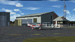
Chester is a small public-use airport in southeastern Connecticut. There is almost always a crosswind on the short, narrow runway. Sharp dropoffs at both ends of the strip make for a tricky approach, but if you can manage it, you'll be rewarded with a neat little airport surrounded by the gorgeous scenery of the Connecticut River Valley. The FBO is top-notch, fuel prices are the best around, and it's one of the last places still selling 80-octane.
Custom Gmax scenery and photo textures. AI traffic with default aircraft included.
| Filename: | KSNC_Chester_Connecticut_formerly_3B9.zip |
| License: | Freeware, limited distribution |
| Added: | 15th November 2009, 00:43:41 |
| Downloads: | 667 |
| Author: | Dave Athay |
| Size: | 1017.03 KB |
| Category: Flight Simulator 2004 - Scenery | |
| Namibia, Southwestern Africa |
|
File Description:
Replacement landclass file for all of Namibia and parts of western Botswana (S15-30 E11-25). Based on the new Global Land Cover 2000 Project data, this landclass file is still quite basic but better (I believe) than the FS original. In addition, I used Ground2K4 to more accurately represent natural and man-made features in five areas throughout the country, including Windhoek, Swakopmund/Walvis Bay, and the Fish River Canyon. Meant to be used with my Namibia LOD9 add-on mesh series. Landclass source files are included.
| Filename: | Namibia_Southwestern_Africa.zip |
| License: | Freeware, limited distribution |
| Added: | 12th April 2004, 23:44:03 |
| Downloads: | 5,520 |
| Author: | Holger Sandmann |
| Size: | 2.31 MB |
| Category: Flight Simulator 2004 - Scenery | |
| Botswana 30 airports |
|
File Description:
There are 30 airports where most airstrips and few airport concrete. Please follow instructions in my readme.txt.
Airports are code and city:
FB0A - Two Rivers,FB02 - Arizona,FB05 - Cement,FB07 - Chitabe,FB08 - Chobe,FB10 - Deception Valley,FB1T - Tau Pan,FB25 - Hunda,FB29 - Kanana,FB38 - Lebala,FB41 - Linyanti,FB50 - Mombo,FB57 - Nxabega,FB60 - Omdop,FB62 - Piajio,FB66 - Santawani,FB71 - Serunga,FB73 - Shindi,FB74 - Stanley Post,FB82 - Tsodilo Hills,FB88 - Vumbura,FB93 - Xaranna,FB95 - Xigera,FB97 - Xudum,FBCO - Camp Okavango,FBJA - Jao,FBKR - Khwai River Lodge,FBNX - Nxamasen,FBSL - Selinda,FBSV - Savuti, and FBXB - Xaxaba.
| Filename: | Botswana_30_airports.zip |
| License: | Freeware |
| Added: | 24th December 2021, 01:03:17 |
| Downloads: | 200 |
| Author: | Stuart John Gilbert II |
| Size: | 5.07 MB |
| Category: Flight Simulator 2004 - Scenery | |
| Landscape Enhancements for Ultimate Terrain Canada/Alaska |
|
File Description:
This is a re-issue of my previously published landscape enhancement packages for parts of Southeast Alaska, British Columbia, Alberta, and Washington State. These files have been edited and adjusted to be fully compatible with FlightOne's "Ultimate Terrain: Canada/Alaska" product. Also, I have adjusted some of Ultimate Terrain's lake and river elevations to better fit new third-party add-on mesh files, such as the "Cordillera" mesh by FS Genesis and my freeware mesh files made for the individual coverage areas. Please note: A registered copy of "Ultimate Terrain: Canada/Alaska is required!!!
| Filename: | Landscape_Enhancements_for_Ultimate_Terrain_Canada.zip |
| License: | Freeware, limited distribution |
| Added: | 8th June 2005, 03:47:26 |
| Downloads: | 7,332 |
| Author: | Holger Sandmann |
| Size: | 3.44 MB |
| Category: Flight Simulator 2004 - Scenery | |
| Aquile Randagie |
|
Images related to this file:
File Description:

Aquile Randagie (Roving Eagles) airstrip. Located in the Village of Sorga, near Verona is a nice little airport to take-off and fliying on the river Po and the Lake of Garda. Scenery made with original photoreal images and textures with original building. Made with GMax, SBuilder, ADE and Instant Scenery.
Cicare CH-7 Angel single seat, kit helicopter by Lasse Lindh, is included in pack.
This Scenery requires the library VEGETATION10 by Laszlo Variu. You can find it on several Flight Simulator related download services.
| Filename: | Aquile_Randagie.zip |
| License: | Freeware |
| Added: | 24th October 2012, 23:32:24 |
| Downloads: | 378 |
| Author: | Andrea Reani, Lasse Lindh |
| Size: | 8.61 MB |
| Category: Flight Simulator 2004 - Scenery | |
| Edinburgh Island, FOX-2, Horton River, Igloolik, & Kimmirut, adapted for the FSGenesis 76m North Canada Terrain Mesh |
|
Images related to this file:
File Description:
These are replacement bgl's to convert five northern Canada fields for use with the FSGenesis 76m terrain mesh for northern Canada. The five are Edinburgh Island CWEI, the FOX-2 DEW line station, Horton River CWHR, Igloolik CYGT, and Kimmirut CYLC. These are not stand-alone, and the presumption is that you have already downloaded and installed the previously posted sceneries. This installation consists solely of replacing the existing scenery bgl's with the new. There will be further posts of northern airfields in groups of five, alphabetically, and observations regarding the amendments and any further corrections that are required would be welcomed.
| Filename: | Edinburgh_Island_FOX2_Horton_River_Igloolik__Kimmi.zip |
| License: | Freeware, limited distribution |
| Added: | 10th September 2017, 19:29:57 |
| Downloads: | 86 |
| Author: | Roger Wensley |
| Size: | 3.55 MB |
| Category: Flight Simulator 2004 - Scenery | |
| Helmericks 22AK on the North Slope, Alaska |
|
Images related to this file:
File Description:
Helmericks is on the northern coast of Alaska, 150 miles east of Barrow and 50 miles west of Prudhoe Bay. It is on the shore of Colville Island in the delta of the Colville River, and hasn't changed much from when Harmon Helmericks set up house there in the late 1950's. He lived there with his wife and two sons guiding hunting trips and running a fishing operation, and then in 1966 he was involved in the first north slope exploratory oil well drilling operation by Sinclair Oil, which was to lead to the opening up of the north slope in the 1970's. Read "The last of the Bush Pilots" if you want to know more about it. The dirt runway is around 2,400 feet long (long enough for the Wien DC3 to get in with supplies) and the house is still there along with storage sheds. To the southwest are the other houses (three of them) which make up the rest of Colville Village. If you want to have the frozen lakes and river and sea then look for my recent post which will freeze them until you get bored and want to put your floats back on.
| Filename: | Helmericks_22AK_on_the_North_Slope_Alaska.zip |
| License: | Freeware, limited distribution |
| Added: | 17th April 2010, 16:21:03 |
| Downloads: | 392 |
| Author: | Roger Wensley |
| Size: | 1.22 MB |
| Category: Flight Simulator 2004 - Scenery | |
| Updates for Rockcliffe CYRO in Ottawa Canada |
|
Images related to this file:
File Description:
Flight Ontario posted their scenery for CYRO in 2008. I originally learned to fly at Rockcliffe Flying Club and came up with some additions and modifications in 2009, and now with the passage of time there are more changes. This version replaces the previous updates and is a self-contained version.
A mini tornado in 2009 destroyed the old willow tree and almost put paid to the clubhouse too (though all the buildings are still standing right now) so there is a new (temporary) clubhouse, a new hangar, the willow tree is gone, the car park is enlarged and is now asphalt, the fence line is revised and the entrance gate relocated. The previous modifications included the refueling point near the RFC buildings, revised apron shape, gravel car park, parked cars, extended perimeter fence, deck in front of the RFC clubhouse, more parked planes, the large and old willow tree, and the float dock in the river. Note in the winter picture the Ottawa River is frozen, as it is right now in reality, and you can download my "Frozen Lakes etc" post and turn your own Canadian winter into reality; I have been surprised by how few people are interested in winter flying in FS9.
| Filename: | Updates_for_Rockcliffe_CYRO_in_Ottawa_Canada.zip |
| License: | Freeware, limited distribution |
| Added: | 5th March 2010, 18:05:35 |
| Downloads: | 567 |
| Author: | Roger Wensley |
| Size: | 2.43 MB |
| Category: Flight Simulator 2004 - Scenery | |
| CYDA - Dawson City - Yukon Territory, Canada |
|
Images related to this file:
File Description:
Dawson City is in the Yukon Territory, Canada, 140 miles south of Old Crow and about the same north of Whitehorse. The town has a population of just over 1,300 and is on the bank of the Yukon River; it is busy with nearby gold mining and tourism. There are regular flights by Air North, the Yukon airline, and I have included them in the AI along with ConAir and GA. Thanks go to Hernan for his Air North textures. The airport is beside the Klondike Highway that links Dawson City to Whitehorse, a few miles southwest of the town and the river. The runway approaches are steeper than most because of the surrounding hills and the Canada Flight Supplement notes that use is restricted to daylight hours, with some exceptions including emergencies. Runway 20 has right hand circuits. The runway is gravel and just over 5,000 feet long, aligned 02-20. There is a second apron for the activities of ConAir etc in the summer fire-fighting months. The "masts" are actually for fire hose drying; the ends of several 50 feet lengths are attached to a circular holder that is then pulled up to the top of the central pole.
| Filename: | CYDA__Dawson_City__Yukon_Territory_Canada.zip |
| License: | Freeware, limited distribution |
| Added: | 27th December 2014, 20:31:31 |
| Downloads: | 377 |
| Author: | Roger Wensley |
| Size: | 3.96 MB |
| Category: Flight Simulator 2004 - Scenery | |
| Koyukuk KYU in Alaska |
|
Images related to this file:
File Description:
Koyukuk is a small village on the northern bank of the Yukon River, around 5 miles east of where the river turns from north-south to east-west, east being upstream towards the distant Fairbanks. The mouth of the Koyukuk River that joins the Yukon is just to the east of the village. The population is now under 100 and living from fishing and the land. During the late 1800's the local population lived off the land and also by the spin off from gold mining in the same way as the nearby Nulato, but when in the early 1900's gold mining activities moved to Nome and Fairbanks local prosperity plunged. In fact, the village only became a permanently inhabited establishment in 1939, when a school was built. The airfield is close by and has a gravel runway aligned 6-24 and 4,000 feet long with PAPI on the approach to 6. There is also a shorter and parallel grass runway that is only used in the winter snows by light planes that are on skis and without wheels. Apart from the airfield itself, and it's buildings, this scenery modifies the local land class, adds village buildings while reducing the village size to reality, and creates a new airfield background. Koyukuk is served by Wright Air from Fairbanks in the east and this is included in the AI provided with the post of Nulato. A note here about my scenery making. This is post number 509 and there will not be many more to follow this as I am almost at the end of the photos I either took or found for scenery purposes. There is a limit to what can be located online and I have already been making use of the little there is; eg Unalakleet. So, if you are near an airport (preferably Canadian or Alaskan) and have a camera..... Let me know.
| Filename: | Koyukuk_KYU_in_Alaska.zip |
| License: | Freeware, limited distribution |
| Added: | 30th August 2019, 18:23:12 |
| Downloads: | 124 |
| Author: | Roger Wensley |
| Size: | 3.26 MB |
© 2001-2026 AVSIM Online
All Rights Reserved
Privacy Policy |