
Where Flight Simulation Enthusiasts Gather from Around the World!
AVSIM Library - Search Results

| Category: Flight Simulator 2004 - Scenery | |
| Talkeetna Village AK44 in Alaska, REVISED |

|
Images related to this file:
File Description:
The town of Talkeetna is around 75 miles north of Anchorage in Alaska, on the east shore of the Susitna River where the Susitna, Talkeetna, and Chulitna rivers join. The town is where Don Sheldon started Talkeetna Air Services. His story is told in "Wager With The Wind" by James Greinar and is well worth reading for the descriptions of mountain flying. There are two airfields at Talkeetna, PATK with its long asphalt runway and Talkeetna Village AK44 in the town. This is AK44; measuring the space left for the runway between the river bank in the south and the curve in the road that marks the north end of the field there is just enough space for the 900 feet of runway that is described in the book. The result is a step back in time to 1973, when the second hangar was built. Neither hangar has survived to today.
| Filename: | Talkeetna_Village_AK44_in_Alaska_REVISED.zip |
| License: | Freeware, limited distribution |
| Added: | 18th April 2010, 09:52:26 |
| Downloads: | 869 |
| Author: | Roger Wensley |
| Size: | 3.47 MB |
| Category: Flight Simulator 2004 - Scenery | |
| Canyonlands National Park, The Maze-North, Utah, Photo-Scenery (FSX too) |
|
Images related to this file:
File Description:
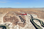
This is a re-upload of a package that was corrupted during the crash of the AVSIM library. The Maze is the wildest and least accessible district of Canyonlands National Park. It is a perplexing jumble of canyons that has been described as a '30 sq miles puzzle in sandstone'. The Maze covers the area west of the Green River and north of the Colorado River. Getting to most locations requires multiple hours of 4WD road driving. Hiking trails usually require multi day backpack trips.
Too strenous? Let's go flying! Checking out the area from an eagles perspective is certainly a stunning experience. The colors are awesome and the landforms are of breathtaking beauty. The scenery extends my Arches National Park scenery to the west and brings you another 3.500 sq km in 4.7m/pix quality. YourDonation@Work: Dedicated to Frans, Francois and James. Thanks!
| Filename: | Canyonlands_National_Park_The_MazeNorth_Utah_Photo.zip |
| License: | Freeware, limited distribution |
| Added: | 31st December 2009, 11:01:39 |
| Downloads: | 2,371 |
| Author: | Gottfried Razek - blueskyscenery.com |
| Size: | 92.88 MB |
| Category: Flight Simulator 2004 - Scenery | |
| Bethel: St Mary's area airfields in southwest Alaska close to the Yukon River |
|
Images related to this file:
File Description:
This presumes you have already installed Bethel PABE and Bethel Local Airfields. In the Yukon River area of Alaska to the north of Bethel there are small villages, served by flights from both Bethel and the nearer St Mary's PASM. St Mary's has a gravel runway like the other villages, but has a larger population and airport services including maintenance and fuel. This, plus the saving of an average one hundred miles of flying by a Cessna 205 when compared with flights from Bethel, means it acts as a distribution centre fed from Bethel by larger aircraft. Go to "http://vfrmap.com/" for free vfr maps of the area (see the attached). The ten village airfields included here are all to the north and west of St Mary's: Hooper Bay PAHP, Chevak VAK, Cape Romanzof PACZ (closed air force field servicing a radar station), Scammon Bay SCM, Sheldon Point SXP, Alakanuk AUK, Emmonak PAEM, Kotlik 2A9, Mountain Village MOU, and of course St Mary's PASM itself. With these airfields not everything is as it appears to be. For instance, Hooper Bay is not a new and modernised airfield, despite the asphalt runway and apron; the current version has dispensed with the aging asphalt and gone back to gravel. I have tended to go for the 2005 or so versions, which sometimes means a small runway amid or close to the housing; Kotlik was an early renewal for reasons of safety as much as anything else and has had (since 2003?) a new and longer runway located outside of the town. The second batch of airfields will be to the east of St Mary's.
| Filename: | Bethel_St_Marys_area_airfields_in_southwest_Alaska.zip |
| License: | Freeware, limited distribution |
| Added: | 29th April 2019, 17:07:24 |
| Downloads: | 225 |
| Author: | Roger Wensley |
| Size: | 11.53 MB |
| Category: Flight Simulator 2004 - Scenery | |
| Alaska South Slope 7; Kobuk OBU & Dahl Creek DCK |
|
Images related to this file:
File Description:
There are four main northwestern Alaska towns which are serviced by Alaska Airlines, and from which local flights spread out. The northernmost is Barrow. Southwest of Barrow is Kotzebue, then Nome, and the furthest south is Bethel (not yet made). This is a continuation of the series for the flights from Kotzebue, 170 miles to the east where Kobuk is on the bank of the Kobuk River, and Dahl Creek is 2 miles to the north. Kobuk is a small village on the Kobuk River, like Ambler and Shungnak, but with a population of only around 150. The river is the reason for the existance of the villages as it served (and still does) as both a source of food and a transport route. The airfield is just beside the village, with a runway around 4,500 feet of lit gravel and aligned 09-27, with PAPI on both ends. There are scheduled flights by Era (now renamed Ravn) and by Bering Air, both of them originating in Kotzebue and routing east to Ambler, Shungnak, Kobuk, and then back again. The AI includes these flights along with Everts Air and GA. The FS9 airfield has been relocated by approximately a mile to the correct position, and the elevation accordingly adjusted. The Dahl Creek strip is publicly owned, with no maintenance and a deteriorating gravel runway that has not long to survive. This probably does not work properly without Ultimate Terrain Alaska Canada as the village is now on the river bank. I am presuming that you have downloaded and installed Nome PAOM, along with the instructions on how to adjust Ultimate Terrain Alaska Canada to get the most realistic results. If you are not making the UT adjustments then you may be seeing duplicated roads, as I am including new local dirt or gravel roads to connect village to airfield etc to get the best overall result; I will not be making alternate versions.
| Filename: | Alaska_South_Slope_7_Kobuk_OBU__Dahl_Creek_DCK.zip |
| License: | Freeware, limited distribution |
| Added: | 13th October 2016, 18:10:08 |
| Downloads: | 232 |
| Author: | Roger Wensley |
| Size: | 2.94 MB |
| Category: Flight Simulator 2004 - Scenery | |
| FS9 Allakaket 6A8 in Alaska |
|
Images related to this file:
File Description:
Allakaket is on the Koyukuk River in Alaska, 40 miles southwest of Bettles. The population is just over 100, with a school that was opened in 1957 for both Allakaket and the nearby Alatna on the other side of the river. There was a very serious flood in 1964 with almost all of the village being underwater, and this resulted in the establishment of an additional housing area further inland and explains the thinly scattered housing in the original village site. The airfield was established in 1978 and has a gravel runway aligned 5-23 (or 05-23 if you are not American) that is just over 4,500 feet in length. Both the runway and the taxiway are marked with lit cones. The village airfield is served by Wright Air and Warbelows Air, both of them being based in Fairbanks and included in the revised AI for PANN that is included here. There are occasional other larger freight flights as required as there is no road access to the village and the river is too shallow to allow large freight barges; hence the runway length.
A note here about my scenery making. There will not be many more to follow this as I am almost at the end of the photos I either took or found for scenery purposes, plus I expect to move on from FS9 at some point during next year.
| Filename: | FS9_Allakaket_6A8_in_Alaska.zip |
| License: | Freeware, limited distribution |
| Added: | 23rd November 2019, 20:29:35 |
| Downloads: | 122 |
| Author: | Roger Wensley |
| Size: | 3.78 MB |
| Category: Flight Simulator 2004 - Scenery | |
| Astrakhan City topology and autogen |
|
Images related to this file:
File Description:

I'm pleased to introduce you the project of topology and autogen of Astrakhan city, Russia, version 1.0b. The project is for MS Flight Simulator 2004.
This projects changes the default autogen of the city and its neighborhood, that doesn't correspond to the real city. Also it adds missing rivers, islands, roads, railroads, and bridges in the vicinity of the city and Astrakhan aerodrome (URWA) and removes non-existent bridges across the Volga river.
This scenery is not professional since I designed it to my own cheek in Ground2K4 to replace the default terrible scenery and make my flights to homeland more comfortable. That's why it is probable, that you can face some challenges (although, I didn't see any problems yet). The project has several disadvantages: all bridges are autogen, so they don't look very similar to real ones (but they are better, that their absence and presence of several non-existent :) ); no autogen on added islands (although the autogen option for them is set on in Ground2K4), I will continue to work on it; rivers that fall into the Volga river have the default shoreline visible at theirs mouths (it's possible to remove it, but only on the square of big area, in that case the river-land transition doesn't look real).
Overall, this project is more for IFR flights, than VFR. But, again, even for VFR flights it's much better than the default crap (imho!).
| Filename: | Astrakhan_City_topology_and_autogen.zip |
| License: | Freeware |
| Added: | 2nd July 2010, 15:18:39 |
| Downloads: | 430 |
| Author: | Valery 'Oracle' Smirnov |
| Size: | 11.23 KB |
| Category: Flight Simulator 2004 - Scenery | |
| Chisasibi CSU2 in northern Quebec, Canada |
|
Images related to this file:
File Description:
Chisasibi is in northern Quebec on the east shore of James Bay, 60 miles from the corner of James Bay and Hudson Bay. Originally called Fort George and founded at the mouth of La Grande Riviere around the Hudson Bay trading post that was established in 1803, the town had to move 5 miles upstream in 1981 when the Quebec hydro project increased the flow rate of the river. The name was changed to Chisasibi at the time of the move (Chisasibi = Great River in Cree) and the population (750 as early as 1940) has now grown to around 2,000. There is a paved road east to Radisson that connects to the north-south James Bay road, which was built at the time of the hydro project work. The original Fort George airport runway is still visible but not usable, just south of the original town site. Chisasibi airport is to the west of the new town, and the gravel runway is 3,792 feet long and aligned 14/32, which is approximately parallel to the river. There is officially no fuel available, but there is JetA on site for Air Creebec in a tank protected by used fuel drums (filled with sand?). The terminal and the garage building are both relatively new; the terminal dates from 2002 and has unusual touches. There are two AI flights by Air Creebec each day plus other private planes.
| Filename: | Chisasibi_CSU2_in_northern_Quebec_Canada.zip |
| License: | Freeware, limited distribution |
| Added: | 27th February 2013, 21:24:47 |
| Downloads: | 287 |
| Author: | Roger Wensley |
| Size: | 2.79 MB |
| Category: Flight Simulator 2004 - Scenery | |
| CYVP - Kuujjuaq - Quebec, Canada |
|
Images related to this file:
File Description:
Kuujjuaq is in northern Quebec at the southern end of Ungava Bay, and 30 miles up the Koksoak River. Kuujjuaq has a population of around 2,400; it was previously called Fort Chimo and in 1830 there was a Hudson Bay trading post established close by, but on the other bank of the river. A nursing station and a school were established in 1948 and the Hudson Bay post moved across the river to the current location. The airport is to the south of the town and, unusally for northern airfields, has two runways. The asphalt runway is 6,000 feet long and aligned 07/25, and the gravel runway is 5,000 feet long and aligned 13/31; 07 has ILS. There is fuel available, both 100LL and JetA, but the 100LL will be in drums and you are required to have your own pump. There are numerous flights that stop at Kuujjuaq; the AI included here has Air Creebec, First Air, Wasaya Airways, and Air Inuit (Kuujjuaq is a maintenance centre for Air Inuit) plus private flights by various aircraft. There is also a flight by my poor representation of a Helicopter Transport Services chopper. There is a float base on the nearby Stewart Lake during the summer months. The base is within the Kuujjuaq control zone, and normally you would talk to the tower and inform them of your intentions, but in FS9 this cannot be replicated.
| Filename: | CYVP__Kuujjuaq__Quebec_Canada.zip |
| License: | Freeware, limited distribution |
| Added: | 11th February 2013, 06:22:50 |
| Downloads: | 812 |
| Author: | Roger Wensley |
| Size: | 5.92 MB |
| Category: Flight Simulator 2004 - Scenery | |
| Bill's Cabin scenery, West Virginia. |
|
File Description:
Bill's Cabin is situated on the shore of the Great Kanawha river adjacent to Leon (W07) grass strip. (No relation to the author). You can land there and taxi to the cabin. There is docking for seaplanes and lots of candies. Sounds included for those who have the Lago program. I will issue shortly a separate scenery for the grass strip. Should work fine in FS2002 also (see note inside).
| Filename: | Bills_Cabin_scenery_West_Virginia.zip |
| License: | Freeware |
| Added: | 20th February 2004, 13:01:36 |
| Downloads: | 1,651 |
| Author: | Leon Louis |
| Size: | 3.12 MB |
| Category: Flight Simulator 2004 - Scenery | |
| Le Bic Scenery With Northern Lights, Québec Short Hops |
|
File Description:
Le Bic region, on the South shore of the St.Lawrence River is very beautyfull to visit. My rendering of the scenery is fictitious so is the airfield that I added. This site is loaded with candies, see pictures. Animated Northern Lights greatly enhances the scenery. The airfield has no runway. Just land on the grass. At night, a runway is lit with kerosene torches as it was done then.
| Filename: | Le_Bic_Scenery__With_Northern_Lights_Qubec_Short_H.zip |
| License: | Freeware |
| Added: | 22nd July 2004, 04:08:59 |
| Downloads: | 1,829 |
| Author: | Leon Louis |
| Size: | 5.57 MB |
© 2001-2026 AVSIM Online
All Rights Reserved
Privacy Policy |