
Where Flight Simulation Enthusiasts Gather from Around the World!
AVSIM Library - Search Results

| Category: Flight Simulator 2004 - Scenery | |
| Raiatea Airport, Uturoa, French Polynesia, NTTR |

|
File Description:
This is a total update of the airport at Raiatea in French Polynesia. It is the largest airport in the Society Islands outside of Tahiti. This scenery contains a new realistic terminal, the rustic hangar area, and the tower, along with tropical landscaping, and an afcad by Ray Smith. This island along with all of the Society Islands of French Polynesia are among the most beautiful paradises on Earth. They can all be greatly enhanced by using the terrain mesh by John Applegate, and Rolf Keibel, updated for FS2004 under the name of fpsimesh.zip. There are also some new landclass files for this area which will also greatly enhance this forgotten area in FS, and their location is available in the read me file of this scenery.
| Filename: | Raiatea_Airport_Uturoa_French_Polynesia_NTTR.zip |
| License: | Freeware |
| Added: | 21st May 2004, 15:24:33 |
| Downloads: | 10,657 |
| Author: | Bill Melichar |
| Size: | 3.15 MB |
| Category: Flight Simulator 2004 - Scenery | |
| Exploring Mt Rainier Natl Park 1.0 |
|
File Description:
A complete remapping of Mount Rainier National Park in Washington State. Based upon commercial topographic maps, the designed scenery includes, every hiking trail drawn in meticulous detail including every real life switchback; every lake and small alpine pond 20 feet in diameter and over, modified landclass of alpine, forest & rock; every perennial and many intermittent creeks, all steams and rivers (many braided), a complete glacier mapping of every glacier with custom textures and ice fields on the mountain, a complete mapping of all rock faces and rock, moraine rock deposits, glacier outwash area, mudflows, roads, swamp and marsh areas. Includes some effects. Designed to compliment UT USA and any LOD 9 or 10 mesh. Works well with FS Genesis LOD 10 mesh and Birds Eye View Textures.
| Filename: | Exploring_Mt_Rainier_Natl_Park_10.zip |
| License: | Freeware, limited distribution |
| Added: | 6th February 2006, 01:43:43 |
| Downloads: | 3,228 |
| Author: | Bryan Wallis |
| Size: | 9.22 MB |
| Category: Flight Simulator 2004 - Scenery | |
| Pinal Airpark KMZJ |
|
File Description:
FS2004 Scenery - Pinal Airpark (IATA: MZJ, ICAO: KMZJ) is an airport located in Pinal County, seven miles (11 km) northwest of the central business district (CBD) of Marana, a city in Pima County, Arizona, USA. Its main purpose is to act as a "boneyard" for aircraft. Old airplanes are stored there with the hope that the dry desert climate will prevent rust and other forms of corrosion in case the aircraft is pressed into service in the future. Even so, many aircraft which are brought there wind up being scrapped. Nearby Davis-Monthan Air Force Base provides the same service to the U.S. military. Compatible with both FS default and Ultimate Terrain. EZ Scenery Libraries required. Some included. by JOhn B. Loney, Jr.
| Filename: | Pinal_Airpark_KMZJ.zip |
| License: | Freeware, limited distribution |
| Added: | 16th March 2008, 05:46:41 |
| Downloads: | 1,626 |
| Author: | John B. Loney, Jr. |
| Size: | 7.14 MB |
| Category: Flight Simulator 2004 - Scenery | |
| Time Zone Scenery ver. 1.0 (April 2022) |
|
Images related to this file:
File Description:
Time Zone Scenery is meant to completely replace the default time zone definitions as well as those coming from Dennis Thomson TZ3-TZ4.
Product characteristics:
-Each single squared mile of the earth surface is covered
-All standard time zones are correctly defined
-All non-standard time zones included: those with fraction-of-an-hour difference w.r.t UTC (eg. Iran, Afghanistan, India, Nepal, Myanmar, portions of Australia...)
-All Islands in the Pacific Ocean properly covered, including those in the +13, +14 hours regions or the few cases with fractional hours offset.
-Regions following DST are thoroughly modelled (requires FS Real Time)
-The scenery is updated to the world status as of April 2022
-The scenery is intended for FS9, but should also work on FSX and P3D
| Filename: | Time_Zone_Scenery_ver_10_April_2022.zip |
| License: | Freeware, limited distribution |
| Added: | 12th April 2022, 04:09:21 |
| Downloads: | 211 |
| Author: | Antonio Arreghini |
| Size: | 1.39 MB |
| Category: Flight Simulator 2004 - Scenery | |
| Lauriston TGPZ on Carriacou Island in the Caribbean |
|
Images related to this file:
File Description:
Canrriacou Island, though part of the Grenadines geographically, is south of the island chain known politically as St Vincent and the Grenadines, and with Petite Martinique is a dependency of Grenada. Carriacou is around 7 miles long and 2 miles wide, with a resident population of perhaps 5,000. Lauriston airport is at the southwest end of the island, on the north coast, and the runway is around 2,600 feet and aligned 09/27. There are connecting flights both north and south to the other islands by SVG and LIAT. The terminal is stucco and pastel colours and not exactly new. The airport apron is tight. This is the last of my Caribbean series made for default FS9.
| Filename: | Lauriston_TGPZ_on_Carriacou_Island_in_the_Caribbea.zip |
| License: | Freeware, limited distribution |
| Added: | 6th July 2013, 22:23:03 |
| Downloads: | 643 |
| Author: | Roger Wensley |
| Size: | 2.47 MB |
| Category: Flight Simulator 2004 - Scenery | |
| 0AK1 - Anderson Lake - Anchorage, Alaska - USA |
|
Images related to this file:
File Description:
Anderson Lake 0AK1 is in Alaska, less than 2 miles southwest of Wolf Lake, on the north side of Knik Arm. It is , like Wolf Lake, an airpark, with houses and hangars adjacent to a single runway that is 2,200 feet of asphalt aligned 08-26. The runway is lit but the taxiways are not. There are hangars and aprons at the western end that are not "attached" to houses, with an adjacent strip mall. There is also a smaller apron at the eastern end. In the first screenshot Anderson Lake is in the foreground (at the eastern end of the lake of the same name) with Wolf Lake visible behind it.
| Filename: | 0AK1__Anderson_Lake__Anchorage_Alaska__USA.zip |
| License: | Freeware, limited distribution |
| Added: | 17th October 2014, 23:14:46 |
| Downloads: | 387 |
| Author: | Roger Wensley |
| Size: | 3.37 MB |
| Category: Flight Simulator 2004 - Scenery | |
| Scott AFB/MidAmerica Airport (KBLV) |
|
Images related to this file:
File Description:
FS2004 Scenery - Scott Air Force Base (IATA: BLV, ICAO: KBLV, FAA LID: BLV) is a base of the United States Air Force in St. Clair County, Illinois, near Belleville. The base is named after Corporal Frank S. Scott, the first enlisted person to be killed in an aviation crash. The base is operated by the 375th Air Mobility Wing (375 AMW) and is also home to the Air Force Reserve Command's 932d Airlift Wing (932 AW) and the Illinois Air National Guard's 126th Air Refueling Wing (126 ARW), the latter two units being operationally gained by the US Air Force's Air Mobility Command (AMC). Created with Instant Scenery 2 by John B. Loney, Jr.
| Filename: | Scott_AFBMidAmerica_Airport_KBLV.zip |
| License: | Freeware, limited distribution |
| Added: | 29th April 2012, 05:39:14 |
| Downloads: | 638 |
| Author: | John B. Loney, Jr. |
| Size: | 2.06 MB |
| Category: Flight Simulator 2004 - Scenery | |
| Oregon and British Columbia Soaring Scenery |
|
File Description:
FS2004 Oregon and British Columbia Soaring Scenery
These files adds some thermals to default Microsoft Scenery for below cities of British Columbia Canada and Oregon,USA:
1.Vancouver City - Evergreen Airport(ICAO-59S)
2.Vancouver City - Pearson Airport(ICAO-KVUO)
3.Scappoose City - Chinook Ultralight Airport(ICAO-52OR)
4.Mcminnville City - Mcminnville Airport(ICAO-KMMV)
5.Salem City - Landsem Air Field(ICAO-4OR7)
6.Albany City - Albany Muni Airport(ICAO-S12)
7.Eugene City - Mahalon Sweet Airport(ICAO-KEUG)
8.Oakland City - Heavens Gate Airport(ICAO-2OR4)
9.North Bend City - Sunnyhill Airport(ICAO-1OR0).
10.Flight Plan and Nav. Log from Evergreen to Sunnyhill Airports.
It is freeware.
By Francisco Vargas.
E-mail:[email protected]
| Filename: | Oregon_and_British_Columbia__Soaring_Scenery.zip |
| License: | Freeware |
| Added: | 5th November 2005, 21:22:15 |
| Downloads: | 759 |
| Author: | Francisco Augusto Vargas Carneiro |
| Size: | 128.85 KB |
| Category: Flight Simulator 2004 - Scenery | |
| UK Farm Strips Vol 3 |
|
File Description:
UK Farm Strips Scenery containing a further 20 private landing strips, all located within, and compatible with, the VFR GM Photoscenery coverage and prepared using the VFR Terrain Mesh. All strips reflect the topographical nature of the fields, so that users may experience the challenge of taking ofF from, and landing on, sloping runways. This scenery is not compatible with FS2002, or earlier versions. This third volume requires the presence of Vol 1 and Vol 2, since it uses objects provided with these initial versions, as well as a few additional objects.
Farms in this volume are spread across the counties of Beds, Cheshire, Gloucs, Hamps, Herts, Herts, Kent, etc. Statics now include a number of Microlights.
| Filename: | UK_Farm_Strips_Vol_3.zip |
| License: | Freeware |
| Added: | 11th September 2005, 22:50:07 |
| Downloads: | 1,596 |
| Author: | Gerry Winskill |
| Size: | 1.93 MB |
| Category: Flight Simulator 2004 - Scenery | |
| 42VA - Virginia Beach Airport & Museum (v1.1) |
|
Images related to this file:
File Description:
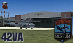
42VA - Virginia Beach Airport & Museum V1.1, located in Virginia Beach, VA USA.
This facility is a private airport used by the Fighter Factory to maintain, display and fly vintage and replica aircraft, mainly from the World War 2 era. The art deco building, grass landing strip, checkered water tower and hangars are home to one of the world's largest private collection of vintage aircraft.
Most objects using custom photo-real 32bit textures designed in GMAX. Optional DXT3 textures included. Also includes new AFCAD file, more accurate airport grounds perimeter, area roads, animated hangar doors, and area landclass. No AI traffic included with this release, but AI functionality designed into AFCAD. By EdGeneer Cox.
| Filename: | 42VA__Virginia_Beach_Airport__Museum_v11.zip |
| License: | Freeware, limited distribution |
| Added: | 5th February 2010, 16:39:44 |
| Downloads: | 1,600 |
| Author: | Ed Geneer Cox |
| Size: | 30.59 MB |


© 2001-2026 AVSIM Online
All Rights Reserved
Privacy Policy |