
Where Flight Simulation Enthusiasts Gather from Around the World!
AVSIM Library - Search Results

| Category: Flight Simulator 2004 - Scenery | |
| Italy, Campania 3, San Severo, Photo Real |

|
Images related to this file:
File Description:
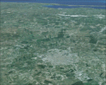
Campania, Italy, Photoreal Scenery Part 3 San Severo.
The photoreal scenery covers a great area of South Italy near Campania around the city of San Severo (see map). The airports of Amendola (ICAO code LIBA) and Gino Lisa (LIBF) are founds near the scenery (see map). For the best results, use it in association with other parts of Campania photoreal: Campania 1 Caserta, Campania 2 Napoli, Campania 4 Benevento, Campania 5 Melfi, Campania 6 Palinuro.
| Filename: | Italy_Campania_3_San_Severo_Photo_Real.zip |
| License: | Freeware |
| Added: | 4th June 2010, 11:18:10 |
| Downloads: | 6,122 |
| Author: | Fulvio Mazzokan |
| Size: | 78.94 MB |
| Category: Flight Simulator 2004 - Scenery | |
| Italy, Campania 5, Melfi, Photo Real |
|
Images related to this file:
File Description:

Campania, Italy, Photoreal Scenery Part 5 (Melfi).
The photoreal scenery covers a great area of south Italy near Campania around the city of Melfi. The airports of Amendola (ICAO code LIBA) and Gino Lisa (LIBF) are founds near the scenery (see map). For the best results, use it in association with other parts of Campania photoreal: Campania 1 Caserta, Campania 2 Napoli, Campania 3 San Severo, Campania 4 Benevento, Campania 6 Palinuro.
| Filename: | Italy_Campania_5_Melfi_Photo_Real.zip |
| License: | Freeware |
| Added: | 1st June 2010, 09:42:22 |
| Downloads: | 5,865 |
| Author: | Fulvio Mazzokan |
| Size: | 78.67 MB |
| Category: Flight Simulator 2004 - Scenery | |
| Rangsdorf Airfield |
|
Images related to this file:
File Description:
Rangsdorf Airfield, the place where Graf Schenk von Stauffenberg once enter a aircraft to kill the fuehrer of the third reich adolf hitler. It was closed in 1990. In former times it was used by the soviet army as helicopter base. In the beginning, it was the homebase of buecker flugzeugwerke till world war II. The airfield is located ca. 2 miles south of Berlin-Schoenefeld Airport which will soon be Berlin-Brandenburg International.
| Filename: | Rangsdorf_Airfield.zip |
| License: | Freeware |
| Added: | 19th July 2014, 17:24:03 |
| Downloads: | 404 |
| Author: | David Kolas |
| Size: | 10.24 MB |
| Category: Flight Simulator 2004 - Scenery | |
| LEST Santiago de Compostela 2018 |
|
File Description:
FS2004 Scenery--LEST Santiago De Compostela, Spain. FULL PACKAGE
1. Airport Scenery with new buildings, parkings, lights positions, taxilines and night textures
2. Photoreal scenery
This scenery was built from the official maps for the runway and taxiways with Google Maps as a background image as support. The different signs were positioned without any documentation or references. Only use with IVAO or VATSIM; no AI possible.
By Serge Libon (airport) and Diego Varela Rodriguez (photoreal)
| Filename: | LEST_Santiago_de_Compostela_2018.zip |
| License: | Freeware |
| Added: | 13th March 2018, 23:02:34 |
| Downloads: | 1,709 |
| Author: | Serge Libon (airport) and Diego Varela Rodriguez (photoreal) |
| Size: | 167.97 MB |
| Category: Flight Simulator 2004 - Scenery | |
| Kilimanjaro International Airport V2 |
|
Images related to this file:
File Description:
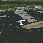
Here is Kilimanjaro International Airport (HTKJ) Version 2. Kilimanjaro International Airport (KIA) (IATA: JRO, ICAO: HTKJ) is an International airport in northern Tanzania that serves the cities of Arusha and Moshi. Scenery was built using Sketchup, Sbuilder and ADE, (Tropical trees API by Bill Melichar) and it consists of a photoreal airport background. Update includes new ramp and taxiway. Needs RWY12 object library (available here on avsim and flightsim). See readme for install instructions
| Filename: | Kilimanjaro_International_Airport_V2.zip |
| License: | Freeware |
| Added: | 19th January 2020, 03:24:41 |
| Downloads: | 721 |
| Author: | Emmanuel Mwandosya |
| Size: | 19.03 MB |
| Category: Flight Simulator 2004 - Scenery | |
| AI-China China Scenery Package |
|
File Description:
This package includes all Chinese airports, including the new ZSPD (with 2 runways) and the ZGGG also built in Huadu GuangZhou. These sceneries are little bit more advanced than the default but obviously do not have the quality of a payware scenery. This package also include the high elevation airports such as ones in Tibet. If you have any problems, please contact the developers whos email will be in the package readme.
| Filename: | AIChina_China_Scenery_Package.zip |
| License: | Freeware |
| Added: | 6th June 2006, 14:21:40 |
| Downloads: | 26,447 |
| Author: | AI-China |
| Size: | 12.69 MB |
| Category: Flight Simulator 2004 - Scenery | |
| OryxSim Salalah International Airport, Dhofar, Oman - Version 1.0 |
|
Images related to this file:
File Description:
OryxSim welcomes you to Salalah International Airport, situated on less than 2 hours flying from major gulf destinations such as Dubai, Abu Dhabi, Bahrain, Doha and Muscat. Salalah is one of the very few cities in the Middle East that experience a Monsoon season. This scenery includes custom ground textures, 3d ground lighting as well extensive night lighting. This is the FS2004 version, a FSX version should be available within two after this release.
| Filename: | OryxSim_Salalah_International_Airport_Dhofar_Oman_.zip |
| License: | Freeware |
| Added: | 10th April 2010, 00:04:33 |
| Downloads: | 2,957 |
| Author: | OryxSim |
| Size: | 8.28 MB |
| Category: Flight Simulator 2004 - Scenery | |
| Cameri and Turbigo sceneries (rev. 3) - north Italy |
|
Images related to this file:
File Description:
The following files are required by this file:
http://library.avsim.net/esearch.php?DLID=163723&UploadID=&Name=&FileName=&Author=&CatID=root
http://library.avsim.net/esearch.php?DLID=186350&UploadID=&Name=&FileName=&Author=&CatID=root
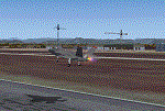
This scenery includes a global review of the previous Sceneries of Cameri Military airport (rev.2 Oct 2011), Cameri Museum (rev. 2 Oct 2011), Cameri Babini (rev. 2 oct 2011), Turbigo power station (rev. 2 Sep 2011 and update rev. 2.1 Oct 2014). All the above ARE NOW INCLUDED in this new unique scenery. Contents: Terrain in new version photo-realistic multi-seasons/night; adapted to Western Europe special elevation meshes; cover area of over 120 sqkm from Bellinzago-Oleggio (NW) to Magnago-Bienate (NE), from Novara (SW) to Cuggiono-Inveruno (SE); all the terrain has been restorated with 3D buildings, either through autogen that with specific dedicated objects (by GMax) and with significant addition of library objects ("dva51" and other existings). This scenery (located on the final approach to the Milan Malpensa international airport) includes the Cameri's Mil Airport with the Babini closed Army area and the planes of the Historical Museum of the airport; it is also included the thermoelectric power station of Turbigo. All the buildings are placed to recreate cities and villages covered in the photo-realistic terrain, including Bellinzago, Bienate, Buscate, Caltignaga, Cameri, Castano Primo, Castelletto Ticino, Cuggiono, Galliate, Inveruno, Magnago, Malvaglio, Nibbia, Novara, Oleggio, Pernate, Robecchetto, Romentino, Sant'Anna, San Pietro Mosezzo, Turbigo , Vanzaghello, and the covered Turin-Milan highway.
Details of the new buildings for the care and maintenance to F35 completely recreated, as obtainable from the current satellite view.
It REQUIRES the use of the following, to be downloaded separately :
- the libraries dva51 - the system of vegetations TreePlanter - the West Europe Meshes of Daniele Lanfranchi. See the Readme file. Enjoy!
Videos available here:
https://dl.dropboxusercontent.com/u/38829151/FS9/Cameri_Turbigo_v3%20shots.WMV
http://youtu.be/yVI2KeJKS5o
http://youtu.be/oKa0e_5kxIk
| Filename: | Cameri_and_Turbigo_sceneries_rev_3__north_Italy.zip |
| License: | Freeware |
| Added: | 21st January 2015, 21:32:36 |
| Downloads: | 995 |
| Author: | Aldo Della Vedova, Daniele Lanfranchi and Gian Mario Verga |
| Size: | 103.7 MB |
| Category: Flight Simulator 2004 - Scenery | |
| Edinburgh Island, FOX-2, Horton River, Igloolik, & Kimmirut, adapted for the FSGenesis 76m North Canada Terrain Mesh |
|
Images related to this file:
File Description:
These are replacement bgl's to convert five northern Canada fields for use with the FSGenesis 76m terrain mesh for northern Canada. The five are Edinburgh Island CWEI, the FOX-2 DEW line station, Horton River CWHR, Igloolik CYGT, and Kimmirut CYLC. These are not stand-alone, and the presumption is that you have already downloaded and installed the previously posted sceneries. This installation consists solely of replacing the existing scenery bgl's with the new. There will be further posts of northern airfields in groups of five, alphabetically, and observations regarding the amendments and any further corrections that are required would be welcomed.
| Filename: | Edinburgh_Island_FOX2_Horton_River_Igloolik__Kimmi.zip |
| License: | Freeware, limited distribution |
| Added: | 10th September 2017, 19:29:57 |
| Downloads: | 86 |
| Author: | Roger Wensley |
| Size: | 3.55 MB |
| Category: Flight Simulator 2004 - Scenery | |
| Red-Brown Night Texture Fix |
|
File Description:
This package replaces 99 of the "LM" night ground textures found in the "Flight Simulator 9/Scenery/World/texture" folder with ones that have been "slightly" darkened. These files retain the correct "street" lighting while losing the red/brown "ground glow" found particularly in the farm textures. The result is a nighttime texture that blends seamlessly with the rest of the FS textures and provides a more realistic night environment. This package also works very well in combination with the FSGenesis US National Landclass Project.
| Filename: | RedBrown_Night_Texture_Fix.zip |
| License: | Freeware |
| Added: | 26th October 2003, 01:55:25 |
| Downloads: | 4,405 |
| Author: | Carlyle Sharpe |
| Size: | 328.41 KB |


© 2001-2026 AVSIM Online
All Rights Reserved
Privacy Policy |