
Where Flight Simulation Enthusiasts Gather from Around the World!
AVSIM Library - Search Results

| Category: Flight Simulator 2004 - Scenery | |
| Bardenas Reales Firing Range Version 1.0 |

|
File Description:
Photorealistic scenery of the Firing Range of Bardenas Reales, in Navarra, Spain, close to LEZG ( N42º10.6',W1º28.0'). Created on 1951, this range was the practice area for air to surface weapons for the spanish air force pilots of EF18M, F1M, F5M and AV8 harriers. Usually is used for other allied forces like USAF F16. Actually the use of the firing range is decreasing @ 20% of the full capacity of 100 operations by day. Only textures 4.75 m/pixel, we recomend mesh EVA4,(http://www.airhispania.com/eva/eva.htm) or similar containing detailed topo of spain. Created By Jose Ramon Rodriguez ( this a present to all my friends of Virtual ZAragoza Airbase - www.basezaragozavirtual.tk -, specially to Diego Novillo by his support and illusion in this, and other projects, thx.
| Filename: | Bardenas_Reales_Firing_Range_Version_10.zip |
| License: | Freeware |
| Added: | 18th July 2006, 19:31:31 |
| Downloads: | 3,873 |
| Author: | Jose Ramon Rodriguez |
| Size: | 13.71 MB |
| Category: Flight Simulator 2004 - Scenery | |
| Ko Samui, Thailand (VTSM) v4.0 |
|
File Description:
Samui is a small, but busy airport on the island of Ko Samui. It is located in Southern Thailand, and is an exotic resort destination. In 1989 Bangkok Airways opened their own airport on the island, which decreased the travel time from Bangkok considerably. The airport is currently served by Bangkok Airways, although an occasional private aircraft will land here. This scenery is a detailed and accurate representation of this airport as it looks today. I consulted with several visitors to the airport, as well as the AIP for Thailand. Landsat imagery was used to modify the shoreline, and a custom landclass is included. Taxiway and parking areas were modified by using AFCAD2. This scenery is compatible with 3rd-party mesh scenery for Thailand.
| Filename: | Ko_Samui_Thailand_VTSM_v40.zip |
| License: | Freeware, limited distribution |
| Added: | 25th April 2004, 21:10:31 |
| Downloads: | 11,739 |
| Author: | Martin Strong |
| Size: | 5.34 MB |
| Category: Flight Simulator 2004 - Scenery | |
| San Francisco Int. (SFO) High Res Ground Scenery |
|
File Description:
This scenery contains high resolution ground scenery for the airport of San Francisco Intl. (SFO). It makes me kind of nostalgic, because that's the area where I first successfully tried my hi-res mesh technique for FS2004. The scenery has a resolution of 1.2m/pix (4.7m/pix is FS2004-standard). Coverage is the area around SFO containing the San Bruno Mountain Park and the San Adreas Res. So it's quiet a sight! And don't forget to bring some flowers :-) The scenery gives best results when combined with with my "San Francisco" standard resolution ground scenery, which covers a much larger area at 4.7m/pix and matches perfectly in color and everything...
Won't work in FSX. For FSX please wait for the upcoming FSX-version of this scenery.
| Filename: | San__Francisco_Int_SFO_High_Res_Ground_Scenery.zip |
| License: | Freeware, limited distribution |
| Added: | 27th November 2006, 10:58:19 |
| Downloads: | 16,817 |
| Author: | Gottfried Razek |
| Size: | 41.8 MB |
| Category: Flight Simulator 2004 - Scenery | |
| Beaver Creek CYXQ in Yukon Territory, Canada |
|
Images related to this file:
File Description:
Beaver Creek is located at mile 1202 of the Alaska Highway, just east of the Alaska/Yukon border. The populaton is around 100 and the main employment is with the Border Agency, the White River First Nation, or with local tourist lodges. The airfield is a mile north of the town and close to the Canadian border post, which is included in the scenery. It was built by Jack Stalberg in the 1960's, and I have no further information beyond the fact that he loved to fly. The airport serves as an "airport of entry", though it is restricted in hours of opening and in the size of aircraft that it can handle; up to a maximum of only 15 seats. The single runway is 3,745 feet long and 100 feet wide, gravel, aligned 13-31 in FS9, lit, and with vasi at both ends. Righthand circuits for runway 13. There is a 340 feet threshold displacement to runway 31, which is of course unmarked on a gravel runway. The terminal building was recently reclad; I don't like it, but they didn't consult me. The ai reflects the sort of traffic the airfield gets; ie brief paperwork stopovers for GA or small charter flights into Canada from Alaska, usually in the mornings.I have adjusted the local scenery terrain levels to remove adjacent hills that I believe do not exist in real life but are part of the Northern Canada terrain mesh that I have installed. If you do not have this mesh you may find that the scenery works fine for you without the API flatten that is included here. The airfield is at 2,129 feet ASL.
| Filename: | Beaver_Creek_CYXQ_in_Yukon_Territory_Canada.zip |
| License: | Freeware, limited distribution |
| Added: | 28th January 2019, 06:19:20 |
| Downloads: | 174 |
| Author: | Roger Wensley |
| Size: | 4.68 MB |
| Category: Flight Simulator 2004 - Scenery | |
| West Sussex Piers |
|
File Description:
The piers and works between Selsey Bill and Beachy Head; at Bognor, Littlehampton, Worthing, Shoreham, Brighton West, and Brighton; mark the route of the low-level air-speed world record flight by Neville Duke in a Hawker Hunter in 1953 at an average speed of 747 mph. This scenery was made for the FS Kiosk at the Tangmere Museum, Sussex, England, to enable visitors to emulate Neville Duke's record flight in the Hunter, and is released to the FS community for that purpose. and any other, such as racing. The zipfile contains two sets of coastal objects for the same area; one is for FS2004 using the default scenery, the other for FS2004 using VFR photo scenery, such as JustFlight's "Photograhic Scenery" or "Roads & Rivers of Europe".
| Filename: | West_Sussex_Piers.zip |
| License: | Freeware |
| Added: | 7th August 2005, 12:55:06 |
| Downloads: | 2,165 |
| Author: | John McKeon |
| Size: | 484.05 KB |
| Category: Flight Simulator 2004 - Scenery | |
| Airstrips of the Czech Republic |
|
File Description:
Around 40 sceneries of small airfields in the Czech Republic, each enhanced with buildings, taxiways, parking spaces and aprons as appropriate, to further facilitate the generation of lightweight AI traffic in the area, without overloading the more major airfields.Inspired by a comprehensive selection of regional lightweight GA aircraft on FlightSim.CZ, all appropriately textured to suit the area, with a matching traffic file, these sceneries are all aligned with the roads, rivers and railways etc. in UT Europe, but should mostly be fine in a default installation or other configuration. These sceneries offer a little more generic detail than the AFCADS available on FlightSim.CZ, but often at the expense of fewer parking areas. As always, you can mix and match to suit your own preferences.
| Filename: | Airstrips_of_the_Czech_Republic.zip |
| License: | Freeware, limited distribution |
| Added: | 22nd May 2025, 22:56:49 |
| Downloads: | 44 |
| Author: | Chris Eve |
| Size: | 274.18 KB |
| Category: Flight Simulator 2004 - Scenery | |
| Gustavo Rojas Pinilla International Airport (SKPS) 2011 |
|
File Description:
Gustavo Rojas Pinilla International Airport (IATA: ADZ, ICAO: SKSP) is the leading airport in the archipelago of San Andres, Providencia and Santa Catalina, which has enough capacity to receive large aircraft, due to a number of
charter flights and seasonal in different parts of America and Europe.
This file has the right coordinates, with the apron and characteristics of the airport. The runways were reoriented to the correct direction, runway were re-sized the gates placed on correct location and number, FAC was placed
(Colombian Air force and Colombian National Army) all the airport charts required to navigate in and out of this airport can be found at www.aerocivil.gov.co/ under Informacion Aeronautica click AIP; on AIP
click Aerodromos then click at SKSP.
| Filename: | Gustavo_Rojas_Pinilla_International_Airport_SKPS_2.zip |
| License: | Freeware |
| Added: | 23rd August 2011, 02:27:32 |
| Downloads: | 1,361 |
| Author: | Anwar Gonzalez |
| Size: | 6.29 KB |
| Category: Flight Simulator 2004 - Scenery | |
| HLLM Wheelus Air Base 1955-1962 |
|
File Description:
Wheelus AB was a USAF base located in Tripoli Libya until it was closed in 1970. Wheelus served many purposes: as a MATS station; as a Reflex base hosting various bombers for short rotations at different times; and as a gunnery and bombing training facility supporting many United States Air Forces in Europe squadrons which flew in for month long training sessions to practice live gunnery and bomb training exercises at the nearby El-Uotia Gunnery Range. This is also included in the scenery. Separate traffic is provided for 1955, 1957, 1959 and 1962, each schedule reflecting a mix of visiting squadrons and aircraft types. It can get to be a pretty colorful place if you install all those provided for.
| Filename: | HLLM_Wheelus_Air_Base_19551962.zip |
| License: | Freeware |
| Added: | 25th June 2023, 17:30:52 |
| Downloads: | 102 |
| Author: | Al Von Pingel, Ken Lawson, Dan French |
| Size: | 62.89 MB |
| Category: Flight Simulator 2004 - Scenery | |
| Huahine Airport, French Polynesia, NTTH, Fare |
|
File Description:
This is an all new airport on the Island of Huahine in French Polynesia, just a short hop from Bora Bora. It is located in the Society Islands of French Polynesia which contain 98% of the areas population, with Tahiti being the main area of commerce, and urban center. This scenery includes the terminal, and a few rustic hangars and storage facilities. This Island like most in the area is supported by the tourist industry, and they are known for being the most beautiful and romantic Islands in the world. As with all of the airports in this area, this one will be greatly enhanced with the terrain mesh from Rolf Keibel and Johnathan Applegate, under the name FPSIMESH.zip. Afcad by Ray Smith is also included in this file.
| Filename: | Huahine_Airport_French_Polynesia_NTTH_Fare.zip |
| License: | Freeware |
| Added: | 7th May 2004, 12:44:33 |
| Downloads: | 11,738 |
| Author: | Bill Melichar |
| Size: | 2.72 MB |
| Category: Flight Simulator 2004 - Scenery | |
| Perrine Bridge, Twin Falls Idaho Updated |
|
Images related to this file:
File Description:
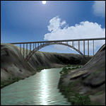
A prominent VFR landmark near Twin Falls Idaho, the Perrine Bridge spans over 1600' and stands 486 feet above the river below. At one time it was the tallest bridge in the world. Perrine Bridge is the only man-made structure in the USA were "base jumping" is allowed without a permit 365 days out of the year. Download includes gmax bridge object, a small photoscenery for the surrounding area, and two saved flight scenarios for exploring the scenery in the default J3 Cub. Bridge surface is landable and crash box has been removed allowing flight beneath the bridge. Scenery is compatible with, and nicely compliments John B. Loney's "Joslin-Magic Valley Regl" airport scenery (ktwf_v1.zip). Requires Ultimate Terrain and freeware mesh product, links provided in the readme.
| Filename: | Perrine_Bridge_Twin_Falls_Idaho_Updated.zip |
| License: | Freeware, limited distribution |
| Added: | 5th July 2011, 04:28:11 |
| Downloads: | 410 |
| Author: | Jim Robinson |
| Size: | 1.52 MB |
© 2001-2026 AVSIM Online
All Rights Reserved
Privacy Policy |