
Where Flight Simulation Enthusiasts Gather from Around the World!
AVSIM Library - Search Results

| Category: Flight Simulator 2004 - Scenery | |
| Alps LOD10 Topo Mesh - Austria and Italy |

|
Images related to this file:
File Description:
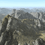
Yet another terrain mesh package of the European Alps? Well, this one is different in that it is NOT primarily based on the Shuttle Radar (SRTM) data with their incomplete coverage of prominent peaks and ridges. Instead, most of the source data for this project were developed over many months by Jonathan de Ferranti using detailed topographic maps. While Jonathan's work is unrelated to flight simulation he kindly gave me permission to compile his data for use in FS. The result is a wonderful improvement in detail and accuracy over any existing SRTM- or DTED-based mesh file, freeware or commercial (a link to an extensive set of screenshot comparisons is included in the read-me file).
I've compiled the source data at LOD10 (38-m) grid resolution because the coverage area is smaller than most existing mesh files. Thus, anyone can use these files without having to first uninstall their current mesh set. Also included are LOD9 and LO8 buffer mesh files. Note: if you own Austria Professional 2004 with its 1:50,000 scale terrain mesh then you don't need this package!
| Filename: | Alps_LOD10_Topo_Mesh__Austria_and_Italy.zip |
| License: | Freeware, limited distribution |
| Added: | 30th May 2010, 09:46:58 |
| Downloads: | 62,947 |
| Author: | Holger Sandmann, Jonathan de Ferranti |
| Size: | 73.32 MB |
| Category: Flight Simulator 2004 - Scenery | |
| "Himalayan Peaks" LOD10 Mesh, Volume 8 - Tirich Mir and Pamir |
|
Images related to this file:
File Description:
Highly detailed terrain mesh of the Tirich Mir and Pamir areas, N36-39 E71-74. The files in this package are based on Shuttle Radar (SRTM) Version 2 data but with many of the void areas, especially the most significant sections, filled with elevation data generated from topographic maps by Jonathan de Ferranti. While Jonathan's work is unrelated to flight simulation he kindly gave me permission to compile his data for use in FS. The result is a wonderful improvement in detail and accuracy over any existing mesh file, freeware or commercial, based on SRTM or DTED data alone.
Due to the large area of the Himalayas I've compiled the source data as two separate series: the "Himalayan Peaks" series covers prominent mountains and ranges in higher detail and locally overrides any existing LOD9 terrain mesh. In addition, a LOD9 "base mesh" series covering the entire Himalayas will be available for those who do not yet have an add-on terrain mesh of these beautiful mountains.
| Filename: | Himalayan_Peaks_LOD10_Mesh_Volume_8__Tirich_Mir_an.zip |
| License: | Freeware, limited distribution |
| Added: | 29th May 2010, 08:52:47 |
| Downloads: | 9,103 |
| Author: | Holger Sandmann, Jonathan de Ferranti |
| Size: | 47.94 MB |
| Category: Flight Simulator 2004 - Scenery | |
| Armenia And Surrounding Area |
|
File Description:
Discover Armenia! This mesh includes the whole territory of Armenia, and also small parts at the borders, Georgia and Aserbaidschan. Also included is Büyük Agri, a 5197 meters high mountain in Turkey to the border to Armenia. SRTM 3 arc-second, resampled to LOD9 (76 meters).
| Filename: | Armenia_And_Surrounding_Area.zip |
| License: | Freeware |
| Added: | 13th April 2004, 03:18:39 |
| Downloads: | 4,681 |
| Author: | Michael Speck |
| Size: | 6.6 MB |
| Category: Flight Simulator 2004 - Scenery | |
| Spain & Portugal Mesh 2004 |
|
File Description:
This scenery cover entire Spain, Portugal and south France till E005. This scenery is compatible with my Italian mesh 2004 scenery.
Based on SRTM 3 arc.sec data.
Unfortunately SRTM DATA have many holes and data loss, so I made a resampling and an oversampling with other data with lower resolution, but with better coverege with geo cad software like Grass and GlobalMapper for projection convertion.
Compression and conversion to bgl with MS Flight simulator SDK at LOD 9
| Filename: | Spain__Portugal_Mesh_2004.zip |
| License: | Freeware |
| Added: | 17th November 2003, 17:04:23 |
| Downloads: | 34,275 |
| Author: | Pietro Mauri |
| Size: | 92.79 MB |
| Category: Flight Simulator 2004 - Scenery | |
| Namibia, Southwestern Africa Mesh Part 2 Of 5 |
|
File Description:
Add-on mesh for the entire country of Namibia (S17-29 E11-21), including the Caprivi Strip east to the Victoria Falls (Zambia/Zimbabwe). The source data are 3-arcsec (~90-m) Shuttle Radar (SRTM) files, compiled at LOD9 (76-m) resolution. Processing with John Childs' Blackart (v3.74) and Peter Guth's MicroDEM (v7.02). Includes a LOD7 buffer mesh to prevent blue slivers in the mid to far distance. Part 2 of 5.
| Filename: | Namibia_Southwestern_Africa_Mesh_Part_2_Of_5.zip |
| License: | Freeware, limited distribution |
| Added: | 5th April 2004, 00:18:13 |
| Downloads: | 5,097 |
| Author: | Holger Sandmann |
| Size: | 21.39 MB |
| Category: Flight Simulator 2004 - Scenery | |
| Namibia, Southwestern Africa Mesh Part 1 Of 5 |
|
File Description:
Add-on mesh for the entire country of Namibia (S17-29 E11-21), including the Caprivi Strip east to the Victoria Falls (Zambia/Zimbabwe). The source data are 3-arcsec (~90-m) Shuttle Radar (SRTM) files, compiled at LOD9 (76-m) resolution. Processing with John Childs' Blackart (v3.74) and Peter Guth's MicroDEM (v7.02). Includes a LOD7 buffer mesh to prevent blue slivers in the mid to far distance. Part 1 of 5.
| Filename: | Namibia_Southwestern_Africa_Mesh_Part_1_Of_5.zip |
| License: | Freeware |
| Added: | 5th April 2004, 00:17:54 |
| Downloads: | 6,375 |
| Author: | Holger Sandmann |
| Size: | 16.03 MB |
| Category: Flight Simulator 2004 - Scenery | |
| EBLG - Liege Airport |
|
File Description:
EBLG - Liege Airport Scenery created with ADE9 v.1.79, SBuilder and static objects libraries with using the latest satellite images available from Google Earth. Optimized for the use with UT Europe and FS Global Mesh 2010.
| Filename: | EBLG__Liege_Airport.zip |
| License: | Freeware, limited distribution |
| Added: | 15th June 2025, 13:59:13 |
| Downloads: | 97 |
| Author: | Taner Akol |
| Size: | 2.89 MB |
| Category: Flight Simulator 2004 - Scenery | |
| Central Volcanic Belt, Mexico 76m SRTM Terrain Mesh & Landclass |
|
File Description:
USGS SRTM 3 arc-second, resampled to LOD9 (76 meters). This is a terrain mesh & landclass scenery of the Central Volcanic Belt in Mexico. The following volcanoes can be found in this area: Popocatepetl, Iztaccihuatl, La Malinche, Pico de Orizaba and Cofre de Perote. Also included are some volcanic eruption effects.
| Filename: | Central_Volcanic_Belt_Mexico_76m_SRTM_Terrain_Mesh.zip |
| License: | Freeware, limited distribution |
| Added: | 11th April 2004, 06:32:55 |
| Downloads: | 7,627 |
| Author: | Andreas Trawny |
| Size: | 2.9 MB |
| Category: Flight Simulator 2004 - Scenery | |
| Azores Islands, North Atlantic Ocean 76m SRTM Terrain Mesh |
|
File Description:
USGS SRTM 3 arc-second, resampled to LOD9 (76 meters). This is a terrain mesh scenery of the Azores Islands in the North Atlantic Ocean. It includes the following islands: Flores, Corvo, Faial, Pico with 7,711 feet (2,351m) high Pico Volcano, Sao Jorge, Graciosa, Terceira, Sao Miguel and Santa Maria.
| Filename: | Azores_Islands_North_Atlantic_Ocean_76m_SRTM_Terra.zip |
| License: | Freeware, limited distribution |
| Added: | 8th April 2004, 03:20:23 |
| Downloads: | 7,984 |
| Author: | Andreas Trawny |
| Size: | 1.81 MB |
| Category: Flight Simulator 2004 - Scenery | |
| Marquesas Islands Scenery 2005 |
|
File Description:
This add-on improves specific scenery area (Marquesas Islands, French
Polynesia) of FS2004. This scenery contains the whole area of Marquesas Islands.
In this scenery, the coastlines were reproduced as close to real as possible,
following the specifications of FS2004.
Moreover, 90m mesh geographical data is reproduced by using SRTM 3arc/sec.
| Filename: | Marquesas_Islands_Scenery_2005.zip |
| License: | Freeware |
| Added: | 21st August 2005, 17:42:05 |
| Downloads: | 3,881 |
| Author: | Kazuo Kawamura |
| Size: | 3.75 MB |
© 2001-2026 AVSIM Online
All Rights Reserved
Privacy Policy |