
Where Flight Simulation Enthusiasts Gather from Around the World!
AVSIM Library - Search Results

| Category: Flight Simulator 2004 - Scenery | |
| South-east Asia SRTM Mesh Part 2 |

|
File Description:
This release covers all of following countries: Thailand, Laos, Kampuchea and Vietnam. Also include parts of Malaysia (Malacca peninsula), Burma (along Thai border) and China (along Vietnam and Laos borders). See SE-Asia-Mesh-part1-1.jpg for detail of BGL coverage. This part includes Thailand-W1 and Thailand-W2 BGL files. Based on SRTM Data (3 arcsec, 90m), generated with Matthew Styles's program "SRTM To BGL v1.04", sampled to LOD9 resolution (76m). John Childs's Blackart program was used to fix large void areas by merging with DTED0 data.
| Filename: | Southeast_Asia_SRTM_Mesh_Part_2.zip |
| License: | Freeware, limited distribution |
| Added: | 1st March 2004, 01:36:06 |
| Downloads: | 12,932 |
| Author: | Yohann Baptiste |
| Size: | 34.46 MB |
| Category: Flight Simulator 2004 - Scenery | |
| South-east Asia SRTM Mesh part 4 |
|
File Description:
This release covers all of following countries: Thailand, Laos, Kampuchea and Vietnam. Also include parts of Malaysia (Malacca peninsula), Burma (along Thai border) and China (along Vietnam and Laos borders). See SE-Asia-Mesh-part4-1.jpg for detail of BGL coverage. This part includes Laos-N BGL file. Based on SRTM Data (3 arcsec, 90m), generated with Matthew Styles's program "SRTM To BGL v1.04", sampled to LOD9 resolution (76m). John Childs's Blackart program was used to fix large void areas by merging with DTED0 data.
| Filename: | Southeast_Asia_SRTM_Mesh_part_4.zip |
| License: | Freeware, limited distribution |
| Added: | 1st March 2004, 13:36:01 |
| Downloads: | 12,587 |
| Author: | Yohann Baptiste |
| Size: | 27.3 MB |
| Category: Flight Simulator 2004 - Scenery | |
| Atlas Mountains, Morocco 76m SRTM Terrain Mesh |
|
File Description:
USGS SRTM 3 arc-second, resampled to LOD9 (76 meters). This is a terrain mesh scenery of the Atlas Mountains in Morocco, Africa. It includes the High Atlas, the cities of Agadir & Marrakech and northwestern parts of the Sahara Desert.
| Filename: | Atlas_Mountains_Morocco_76m_SRTM_Terrain_Mesh.zip |
| License: | Freeware |
| Added: | 4th April 2004, 19:46:58 |
| Downloads: | 15,257 |
| Author: | Andreas Trawny |
| Size: | 15.95 MB |
| Category: Flight Simulator 2004 - Scenery | |
| Northsee Intl |
|
File Description:
This airport.
EHNZ This airport is a special edition from AADG Europe.
This airport is build on water On the Noordzee.
It's verey exclusive.
Please enjoy.
The light's are beautifal...
| Filename: | Northsee_Intl.zip |
| License: | Freeware, limited distribution |
| Added: | 22nd June 2004, 20:39:50 |
| Downloads: | 422 |
| Author: | AADG Europe |
| Size: | 5.55 KB |
| Category: Flight Simulator 2004 - Scenery | |
| Rotterdam Zestienhoven Airport (EHRD) |
|
File Description:
This is EHRD Rotterdam Airport.
Airport has 2 closed grass runway's
One of those runway is gone.
And one is made active again.
And made asphalt and longer with ILS and better runway light. This file requires Afcad 2.11 or higher.
If you don't have that.
No problem.
goto: http://groups.msn.com/aadgeurope.
And goto the Airport Download/Tools and there you can download Afcad 2.21....
Enjoy...
| Filename: | Rotterdam_Zestienhoven_Airport_EHRD.zip |
| License: | Freeware, limited distribution |
| Added: | 23rd June 2004, 19:36:31 |
| Downloads: | 1,969 |
| Author: | AADG Europe |
| Size: | 3.31 KB |
| Category: Flight Simulator 2004 - Scenery | |
| EHNZ Northsee Intl |
|
File Description:
This airport EHNZ.
This airport is a special edition.
From AADG Europe.
It's build on water.
It's verey cool.
The light are verey beautifal.
Enjoy...
| Filename: | EHNZ_Northsee_Intl.zip |
| License: | Freeware, limited distribution |
| Added: | 22nd June 2004, 20:57:10 |
| Downloads: | 617 |
| Author: | AADG Europe |
| Size: | 5.79 KB |
| Category: Flight Simulator 2004 - Scenery | |
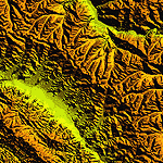
| "Himalayan Peaks" LOD10 Mesh, Volume 4 - Annapurna |
|
Images related to this file:
File Description:

Highly detailed terrain mesh of the Annapurna area, N28-30 E83-85. The files in this package are based on Shuttle Radar (SRTM) Version 2 data but with many of the void areas, especially the most significant sections, filled with elevation data generated from topographic maps by Jonathan de Ferranti. While Jonathan's work is unrelated to flight simulation he kindly gave me permission to compile his data for use in FS. The result is a wonderful improvement in detail and accuracy over any existing mesh file, freeware or commercial, based on SRTM or DTED data alone.
Due to the large area of the Himalayas I've compiled the source data as two separate series: the "Himalayan Peaks" series covers prominent mountains and ranges in higher detail and locally overrides any existing LOD9 terrain mesh. In addition, a LOD9 "base mesh" series covering the entire Himalayas will be available for those who do not yet have an add-on terrain mesh of these beautiful mountains.
| Filename: | Himalayan_Peaks_LOD10_Mesh_Volume_4__Annapurna.zip |
| License: | Freeware, limited distribution |
| Added: | 29th May 2010, 08:59:29 |
| Downloads: | 10,459 |
| Author: | Holger Sandmann, Jonathan de Ferranti |
| Size: | 15.07 MB |
| Category: Flight Simulator 2004 - Scenery | |
| "Himalayan Peaks" LOD10 Mesh, Volume 7 - K2 and Karakoram |
|
Images related to this file:
File Description:

Highly detailed terrain mesh of the Karakoram area, N35-37 E73-77. The files in this package are based on Shuttle Radar (SRTM) Version 2 data but with many of the void areas, especially the most significant sections, filled with elevation data generated from topographic maps by Jonathan de Ferranti. While Jonathan's work is unrelated to flight simulation he kindly gave me permission to compile his data for use in FS. The result is a wonderful improvement in detail and accuracy over any existing mesh file, freeware or commercial, based on SRTM or DTED data alone.
Due to the large area of the Himalayas I've compiled the source data as two separate series: the "Himalayan Peaks" series covers prominent mountains and ranges in higher detail and locally overrides any existing LOD9 terrain mesh. In addition, a LOD9 "base mesh" series covering the entire Himalayas will be available for those who do not yet have an add-on terrain mesh of these beautiful mountains.
| Filename: | Himalayan_Peaks_LOD10_Mesh_Volume_7__K2_and_Karako.zip |
| License: | Freeware, limited distribution |
| Added: | 30th May 2010, 09:56:27 |
| Downloads: | 9,473 |
| Author: | Holger Sandmann, Jonathan de Ferranti |
| Size: | 38.58 MB |
| Category: Flight Simulator 2004 - Scenery | |
| "Himalayan Peaks" LOD10 Mesh, Volume 6 - Jammu and Kashmir |
|
Images related to this file:
File Description:
Highly detailed terrain mesh of the Jammu and Kashmir areas, N31-36 E76-78. The files in this package are based on Shuttle Radar (SRTM) Version 2 data but with many of the void areas, especially the most significant sections, filled with elevation data generated from topographic maps by Jonathan de Ferranti. While Jonathan's work is unrelated to flight simulation he kindly gave me permission to compile his data for use in FS. The result is a wonderful improvement in detail and accuracy over any existing mesh file, freeware or commercial, based on SRTM or DTED data alone.
Due to the large area of the Himalayas I've compiled the source data as two separate series: the "Himalayan Peaks" series covers prominent mountains and ranges in higher detail and locally overrides any existing LOD9 terrain mesh. In addition, a LOD9 "base mesh" series covering the entire Himalayas will be available for those who do not yet have an add-on terrain mesh of these beautiful mountains.
| Filename: | Himalayan_Peaks_LOD10_Mesh_Volume_6__Jammu_and_Kas.zip |
| License: | Freeware, limited distribution |
| Added: | 29th May 2010, 08:55:43 |
| Downloads: | 9,661 |
| Author: | Holger Sandmann, Jonathan de Ferranti |
| Size: | 52.19 MB |
| Category: Flight Simulator 2004 - Scenery | |
| "Himalayan Peaks" LOD10 Mesh, Volume 5 - Garhwal |
|
File Description:
Highly detailed terrain mesh of the Garhwal area, N30°-32° E78°-81°. The files in this package are based on Shuttle Radar (SRTM) Version 2 data but with many of the void areas, especially the most significant sections, filled with elevation data generated from topographic maps by Jonathan de Ferranti. While Jonathan's work is unrelated to flight simulation he kindly gave me permission to compile his data for use in FS. The result is a wonderful improvement in detail and accuracy over any existing mesh file, freeware or commercial, based on SRTM or DTED data alone. Due to the large area of the Himalayas I've compiled the source data as two separate series: the "Himalayan Peaks" series covers prominent mountains and ranges in higher detail and locally overrides any existing LOD9 terrain mesh. In addition, a LOD9 "base mesh" series covering the entire Himalayas will be available for those who do not yet have an add-on terrain mesh of these beautiful mountains.
| Filename: | Himalayan_Peaks_LOD10_Mesh_Volume_5__Garhwal.zip |
| License: | Freeware, limited distribution |
| Added: | 18th February 2006, 23:16:47 |
| Downloads: | 10,130 |
| Author: | Holger Sandmann and Jonathan de Ferranti |
| Size: | 27.72 MB |
© 2001-2026 AVSIM Online
All Rights Reserved
Privacy Policy |