
Where Flight Simulation Enthusiasts Gather from Around the World!
AVSIM Library - Search Results

| Category: Flight Simulator 2004 - Scenery | |
| DBWsim: Saipan 2004 |

|
File Description:
DBWsim’s second scenery for Flightsim2004 covers the Northern Marianas island of Saipan in its entirety, following up our First FS2004 scenery for Tinian. This scenery pack includes fully updated and improved scenery of the remnants of historical WWII airbases on the island, as well as a significantly enhanced full island landclass. There are four abandoned fields on the island, featuring flattened strips that can be used for landing.
| Filename: | DBWsim_Saipan_2004.zip |
| License: | Freeware |
| Added: | 9th January 2004, 15:11:01 |
| Downloads: | 5,359 |
| Author: | Derek Webb, Brendan Webb |
| Size: | 1.87 MB |
| Category: Flight Simulator 2004 - Scenery | |
| DBWsim: Rota 2004 |
|
File Description:
DBWsim’s third scenery for Flightsim2004 covers the Northern Marianas island of Rota in its entirety. This scenery is designed as a companion to our larger scenery packs for Tinian and Saipan (DBWsimTinian.zip and DBWsimSaipan.zip) but is fully stand-alone. This scenery features an enhanced full island land class and airport terminal area.
NOTE: Not Supported for FS2002.
| Filename: | DBWsim_Rota_2004.zip |
| License: | Freeware |
| Added: | 17th January 2004, 19:28:52 |
| Downloads: | 3,525 |
| Author: | Derek Webb, Brendan Webb |
| Size: | 835.79 KB |
| Category: Flight Simulator 2004 - Scenery | |
| DBWsim: Johnston Atoll 2004 |
|
File Description:
This DBWsim scenery for Flightsim2004 covers Johnston Atoll in its entirety. This scenery pack includes fully updated and improved scenery for facilities on the main island and the islands and lagoon surrounding the atoll. The scenery is representative of Johnston Atoll circa 1995, as today there is virtually nothing on the island, not even an airstrip.
Highlights of the scenery are numerous and include; the main street, golf course and outdoor cinema, and Munitions Demilitarization facilities.
| Filename: | DBWsim_Johnston_Atoll_2004.zip |
| License: | Freeware |
| Added: | 10th April 2004, 03:59:16 |
| Downloads: | 4,705 |
| Author: | Derek and Brendan Webb |
| Size: | 2.96 MB |
| Category: Flight Simulator 2004 - Scenery | |
| DBWsim NAS Alameda 2005 |
|
File Description:
DBWsim is proud to present NAS Alameda 2005. Our new scenery re-opens this notable San Francisco bay area airfield. The scenery features comprehensive redevelopment of the Airfield including local coastline and land-class upgrades, providing a significant visual improvement of scenery in the area.
| Filename: | DBWsim_NAS_Alameda_2005.zip |
| License: | Freeware |
| Added: | 1st September 2005, 12:42:48 |
| Downloads: | 6,817 |
| Author: | Derek and Brendan Webb |
| Size: | 2.51 MB |
| Category: Flight Simulator 2004 - Scenery | |
| Midway Atoll 2005 |
|
Images related to this file:
File Description:
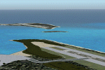
DBWsim presents a new scenery pack for Midway Atoll on the northern tip of the Hawaiian Islands. This pack also includes scenery for French Frigate Shoals (Tern Island) and Kure Atoll. All airports and facilities have been redeveloped along with significant Coastline modification and where possible land-class enhancement.
| Filename: | Midway_Atoll_2005.zip |
| License: | Freeware |
| Added: | 15th May 2010, 08:34:26 |
| Downloads: | 5,261 |
| Author: | Derek and Brendan Webb |
| Size: | 2.88 MB |
| Category: Flight Simulator 2004 - Scenery | |
| John Travolta's Home Airfeild: Greystone 17FL, By DBWsim |
|
File Description:
DBWsim proudly presents Greystone airfield, centrepiece of the Jumbolair estate which is home to John Travolta. The airfield has been extensively redeveloped, realistically portraying the area. The estate section of the field is also accurately covered including detailed scenery of the Travolta house. A localised landclass optimises the appearance of the area. Some areas have been extrapolated based on the best available information and to take into account future development of the estate.
| Filename: | John_Travoltas_Home_Airfeild_Greystone_17FL_By_DBW.zip |
| License: | Freeware |
| Added: | 25th November 2005, 17:01:46 |
| Downloads: | 7,190 |
| Author: | Derek and Brendan Webb |
| Size: | 1.33 MB |
| Category: Flight Simulator 2004 - Scenery | |
| Tarrant Rushton Disused Airfield |
|
File Description:
This is a fairly basic representation of the disused Tarrant Rushton airfield about 18 miles northwest of Bournemouth/EGHH(50.51.00N/02.04.30W).This is sometimes used as a Visual Reporting Point by local traffic
Although the concrete runways were removed many years ago the outlines and the perimeter track are still plainly visible from the air. There are also some hangars remaining.
Made with FSSC by Derek Leung.
| Filename: | Tarrant_Rushton_Disused_Airfield.zip |
| License: | Freeware |
| Added: | 31st May 2004, 03:02:36 |
| Downloads: | 320 |
| Author: | Dave Fagan |
| Size: | 433.92 KB |
| Category: Flight Simulator 2004 - Scenery | |
| RAF Stoney Cross Disused |
|
File Description:
This is a fairly basic representation of the disused RAF Stoney Cross airfield about 12 miles West of Southampton/EGHI( N50.54.45/W 01.39.08).This is sometimes used as a Visual Reporting Point by local traffic.
Although the concrete runways were removed many years ago the outlines are still plainly visible from the air. Also visible are some of the dispersals.Made using FSSC by Derek Leung.
| Filename: | RAF_Stoney_Cross_Disused.zip |
| License: | Freeware |
| Added: | 31st May 2004, 02:59:43 |
| Downloads: | 454 |
| Author: | Dave Fagan |
| Size: | 554.32 KB |
| Category: Flight Simulator 2004 - Scenery | |
| RAF Stoney Cross Disused |
|
File Description:
Stoney Cross N50.54.45/W 01.39.08
This is a fairly basic representation of the disused RAF Stoney Cross airfield about 12 miles West of Southampton/EGHI.This is sometimes used as a Visual Reporting Point by local traffic
Although the concrete runways were removed many years ago the outlines are still plainly visible from the air. Also visible are some of the dispersals. Made using FSSC by Derek Leung.
| Filename: | RAF_Stoney_Cross_Disused.zip |
| License: | Freeware |
| Added: | 31st May 2004, 03:10:09 |
| Downloads: | 510 |
| Author: | Dave Fagan |
| Size: | 554.32 KB |
| Category: Flight Simulator 2004 - Scenery | |
| Tarrant Rushton Disused Airfield |
|
File Description:
TARRANT RUSHTON Disused.50.51.00N/02.04.30W.
This is a fairly basic representation of the disused Tarrant Rushton airfield about 18 miles northwest of Bournemouth/EGHH.This is sometimes used as a Visual Reporting Point by local traffic
Although the concrete runways were removed many years ago the outlines and the perimeter track are still plainly visible from the air. There are also some hangars remaining..Made using Derek Leung'sFSSC.
| Filename: | Tarrant_Rushton_Disused_Airfield.zip |
| License: | Freeware |
| Added: | 31st May 2004, 03:10:50 |
| Downloads: | 382 |
| Author: | Dave Fagan |
| Size: | 433.92 KB |
© 2001-2026 AVSIM Online
All Rights Reserved
Privacy Policy |