
Where Flight Simulation Enthusiasts Gather from Around the World!
AVSIM Library - Search Results

| Category: Flight Simulator 2004 - Scenery | |
| Howick Airfield (FAHC), South Africa |

|
Images related to this file:
File Description:
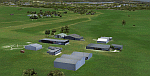
This package will add a custom (Gmax) made Howick Airfield (FAHC), KwaZulu Natal, South Africa with photoreal textures and seasonal ground textures.
Howick is a small town in the KwaZulu Natal Midlands just off the N3 freeway which connects Johannesburg and Durban and home to the famous Howick waterfall. The Umgeni river falls 95m (311 ft) over the cliffs on the way to the Indian Ocean. The town is also home to the Midmar dam. This dam is very well known as being the location of the annual Midmar Mile swimming event which, in 2009, was recognized by the Guinness Book of World Records as the world's largest open water swimming event with 13 755 competitors taking part.
The sloped grass runway is aligned 16/34 and 825m long and sits at an elevation of 3 615ft. Both runways have obstacles on the approach, with powerlines 730m from the threshold of runway 16, while runway 34's approach have hills around 900m before the threshold. The sloped runway has been created in FS2004 within the limits of the simulator itself.
| Filename: | Howick_Airfield_FAHC_South_Africa.zip |
| License: | Freeware, limited distribution |
| Added: | 15th January 2021, 20:25:51 |
| Downloads: | 201 |
| Author: | Kobus van Wyk |
| Size: | 7.67 MB |
| Category: Flight Simulator 2004 - Scenery | |
| Alicante LEAL2007 update SP1 |
|
File Description:
Re-upload of the update SP1 files for LEAL2007. Requires Alicante LEAL 2007 to be installed first.
| Filename: | Alicante_LEAL2007_update_SP1.zip |
| License: | Freeware |
| Added: | 22nd January 2010, 10:27:44 |
| Downloads: | 5,574 |
| Author: | Miguel Angel Perez Soria |
| Size: | 8.23 MB |
| Category: Flight Simulator 2004 - Scenery | |
| Alicante - "El Altet" Airport (LEAL2007) SP1 |
|
File Description:
This patch updates the car parking area and secondary buildings in the scenery.
Also, I've included textures with mipmaps that fixes the shimmering ground textures.
No more patches will be released until the new Terminal Area is finished.
| Filename: | Alicante__El_Altet_Airport_LEAL2007_SP1.zip |
| License: | Freeware |
| Added: | 4th July 2007, 02:56:46 |
| Downloads: | 5,267 |
| Author: | Miguel Angel Perez Soria |
| Size: | 8.23 MB |
| Category: Flight Simulator 2004 - Scenery | |
| El Altet - Alicante's Airport , Spain LEAL2006 |
|
File Description:
This is the rendition of the Alicante's airport, in the Costa Blanca, a very busy airport in holidays season mainly with charter flights.
At the moment at the real airport some modifications are being done (modified parking slots, a provisional ampliation of the terminal,...), those changes have been reflected in this scenery.
This scenery has been made with gmax and photos taken personally at the airport during 2005, July.
No previous files are needed. If you have any previous LEAL sceneries installed, please delete it before install this version.
CHANGES OVER THE LEAL2005_R2:
-Blurry textures fixed.
-Default FS9 runway textures added for improving visual appearance.
-Dark Marshallers textures fixed.
-Urbanova visual reference buildings added and adjusted for various available meshes
| Filename: | El_Altet__Alicantes_Airport__Spain_LEAL2006.zip |
| License: | Freeware |
| Added: | 23rd January 2006, 04:40:37 |
| Downloads: | 16,343 |
| Author: | Miguel Angel Perez Soria |
| Size: | 9.43 MB |
| Category: Flight Simulator 2004 - Scenery | |
| MRAO Turtuguero, Costa Rica |
|
Images related to this file:
File Description:
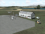
Googly scenery for MRAO Turtuguero, Costa Rica - another one that Microsoft
forgot in FS2004. It is a small domestic airport located on a long spit of
land that almost seems like an island. Turtuguero is just a village but the
airport also serves the lush Tortuguero National Park (rain falls all the
year round here) which draws thousands of visitors each year. The airport
is served daily by DHC-6 Twin Otters of Nature Air.
These scenery files create the airport and add taxiways, aprons, buildings and other airport features, so that you and your "AI" traffic can land, taxi, park and take
off in a realistic manner.The scenery does not purport to be ultra-accurate. Based on less-than-perfect satellite imagery from Google Earth, the layout is as good as I can get it, but some imagination has been used as I cannot tell what buildings exist. The
buildings and other features I have provided are built from default Microsoft
objects and add-on libraries so will not look exactly like the real thing.
You are not obliged to download and install any additional scenery libraries,
but to enjoy this scenery in its entirety, you may wish to. It will work fine,
with or without. [File re-uploaded at request of AVSIM]
| Filename: | MRAO_Turtuguero_Costa_Rica.zip |
| License: | Freeware |
| Added: | 28th May 2010, 20:40:00 |
| Downloads: | 1,174 |
| Author: | John Hinson |
| Size: | 65.12 KB |
| Category: Flight Simulator 2004 - Scenery | |
| Pemberton CYPS in British Columbia Canada |
|
Images related to this file:
File Description:
Pemberton is a small village in the Coast Mountains of British Columbia, with a permanent population of under 3,000 and reliant on logging and increasing tourism. It is around 40 miles north of Squamish and 15 miles north of Whistler and the flight north is best described as scenic. The Nairn Falls, a scenic attraction for tourists, are close by. The runway is 3,920 feet of asphalt aligned 06-24, between and close to the join of the Lillooet River and the Green River. The airfield buildings are to the north of the runway, and at the eastern end is a Fire Base for the expected summer forest fires. To the south and west is the Pemberton Golf Course. All the buildings are replicated, and once again this is not an airport, it is an airfield without any lighting and typical of my future posts which are updated versions of airfield scenery made some time ago and not posted. This one is probably more intricate than most that will follow. The lack of lighting is actually very sensible as landing in the mountains in the dark..... Gun Lake is included here, but not for regular use as it is a deserted dirt strip 40 miles to the north that was once used for fire fighting and there is nothing to see. Just a part of the scenery in this area of BC. If you want to follow this trip on Google Earth the next stop is Cache Creek. If you find a defect, email me. Do not email me about the strange doors to the front of the Blackcomb hangar. I was surprised when I saw it and then discovered that the "doors" are actually flexible curtains that are rolled up and down and if rolled down too far...
I have the ok to use the Bell 212 CCG helicopter as a scenery object, but not to post the entire object library of the Red Deer CYQF scenery; if you have the scenery it should show up here.
| Filename: | Pemberton_CYPS_in_British_Columbia_Canada.zip |
| License: | Freeware, limited distribution |
| Added: | 17th November 2020, 17:29:13 |
| Downloads: | 110 |
| Author: | Roger Wensley |
| Size: | 16.18 MB |
© 2001-2026 AVSIM Online
All Rights Reserved
Privacy Policy |