
Where Flight Simulation Enthusiasts Gather from Around the World!
AVSIM Library - Search Results

| Category: Flight Simulator 2004 - Scenery | |
| Landclass, Edmonton, Alberta, Canada |

|
File Description:
Correct representation of the landscape of Edmonton and surrounding communities using EZ Landclass.
| Filename: | Landclass_Edmonton_Alberta_Canada.zip |
| License: | Freeware |
| Added: | 27th December 2003, 19:59:25 |
| Downloads: | 3,395 |
| Author: | Andy Thomas |
| Size: | 2.61 KB |
| Category: Flight Simulator 2004 - Scenery | |
| Landclass, Hinton, Alberta, Canada |
|
File Description:
Lowers the forest height surrounding CEC4 (Jasper-Hinton airport) Hinton townsite added.
| Filename: | Landclass_Hinton_Alberta_Canada.zip |
| License: | Freeware |
| Added: | 27th December 2003, 19:19:03 |
| Downloads: | 1,481 |
| Author: | Andy Thomas |
| Size: | 1.59 KB |
| Category: Flight Simulator 2004 - Scenery | |
| Tanger Airport GMTT |
|
Images related to this file:
File Description:
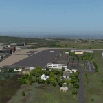
GMTT Tanger Airport Scenery. This Scenery included with default Buildings, Afcads etc. You have to download and install matts_trees11_mixed.zip to see trees in this scenery.
| Filename: | Tanger_Airport_GMTT.zip |
| License: | Freeware |
| Added: | 10th April 2010, 00:06:44 |
| Downloads: | 2,316 |
| Author: | Andy Wedemeyer |
| Size: | 299.98 KB |
| Category: Flight Simulator 2004 - Scenery | |
| SE Alberta 3 Arc Second Mesh |
|
File Description:
Zipdive or check the jpg to see the extent of the mesh.
| Filename: | SE_Alberta_3_Arc_Second_Mesh.zip |
| License: | Freeware |
| Added: | 12th January 2004, 04:12:21 |
| Downloads: | 2,392 |
| Author: | Dwayne Matheson |
| Size: | 11.83 MB |
| Category: Flight Simulator 2004 - Scenery | |
| strm Mesh for Horn Of Africa Part 1/9 |
|
File Description:
strm Mesh for Ethiopia, Erythrea, Djibouti and Sudan Made by FSDEM 1.1
| Filename: | strm_Mesh_for_Horn_Of_Africa_Part_19.zip |
| License: | Freeware |
| Added: | 11th December 2005, 20:39:15 |
| Downloads: | 3,804 |
| Author: | Marcel "Teutonique" Wislet |
| Size: | 16.79 MB |
| Category: Flight Simulator 2004 - Scenery | |
| Galatea Aerodrome - NZGA |
|
Images related to this file:
File Description:
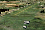
Aerodrome 27nm SE of Rotorua. Made for Christian Stock's NZ 20m mesh.
| Filename: | Galatea_Aerodrome__NZGA.zip |
| License: | Freeware |
| Added: | 15th January 2011, 19:08:44 |
| Downloads: | 204 |
| Author: | Godfrey Tier |
| Size: | 448.93 KB |
| Category: Flight Simulator 2004 - Scenery | |
| Costa Rica Terrain Mesh |
|
File Description:
Terrain mesh scenery for the country of Costa Rica (Central America). See enclosed CostaRica_Map.jpg for the boundaries of this scenery. Made in LOD9 (76.4m) based on SRTM DATA (3 arc/ sec). This mesh scenery should also run in FS2002without any problems.
| Filename: | Costa_Rica_Terrain_Mesh.zip |
| License: | Freeware, limited distribution |
| Added: | 24th August 2003, 02:49:35 |
| Downloads: | 7,469 |
| Author: | Jozef Kusters |
| Size: | 5.99 MB |
| Category: Flight Simulator 2004 - Scenery | |
| Hamilton Island YBHM Australia |
|
File Description:
Re-upload. New scenery about Hamilton Island YBHM - Australia with AFCAD file
| Filename: | Hamilton_Island_YBHM_Australia.zip |
| License: | Freeware |
| Added: | 2nd June 2010, 01:48:58 |
| Downloads: | 1,911 |
| Author: | Claude Schmidt |
| Size: | 2.91 MB |
| Category: Flight Simulator 2004 - Scenery | |
| Iraq VFR Southern - Terrain Mesh SRTM |
|
File Description:
Iraq VFR Southern - Enhanced Terrain Mesh SRTM. This scenery area is a terrain mesh SRTM 3 arc/sec (LOD 9) 76 mt., of part Southern of the Iraq and Kuwait.
This scenery area include whole region around Bassora city and Kuwait city.
| Filename: | Iraq_VFR_Southern__Terrain_Mesh_SRTM.zip |
| License: | Freeware |
| Added: | 30th September 2005, 23:46:11 |
| Downloads: | 2,675 |
| Author: | Giovanni Miduri |
| Size: | 13.89 MB |
| Category: Flight Simulator 2004 - Scenery | |
| Schwaebische Alb, South Germany |
|
File Description:
This is a Mesh for the Schwaebische Alb, located in South Germany.
The highest mountain of this area is Lemberg with 1015 meters.The mesh covers the area N48 E8 to N48 E10. USGS SRTM 3 arc-second, resampled to LOD10 (38 meters).
| Filename: | Schwaebische_Alb_South_Germany.zip |
| License: | Freeware |
| Added: | 14th April 2004, 16:35:25 |
| Downloads: | 3,857 |
| Author: | Michael Speck |
| Size: | 7.4 MB |
© 2001-2026 AVSIM Online
All Rights Reserved
Privacy Policy |