
Where Flight Simulation Enthusiasts Gather from Around the World!
AVSIM Library - Search Results

| Category: Flight Simulator 2004 - Scenery | |
| Sioux Lookout CYXL in northern Ontario, Canada, updated |

|
Images related to this file:
File Description:
This greatly modifies my previous post of Sioux Lookout; it is stand-alone and does not require you to have the 2009 version. The AI provided with the post complements what was included with Dryden (March 2013). Sioux Lookout is in northern Ontario, 40 miles east of Dryden, and 145 miles northwest of Thunder Bay. The town is on the northeastern shore of a lake that I don't know the name of (I've been there, but has anyone COUNTED how many lakes Canada has?). It has a population of around 5,000. The main businesses are lumber, tourism, and health care. The airport is immediately adjacent to the northeastern corner of the town, and has 5,300' of asphalt which is aligned 16-34. There are two taxiways which curve and climb up to the apron which is 20 or 30 feet higher. When you taxi on them the knowledge that in reality you would be climbing makes sense of the curved routing. The apron is large and a mixture of asphalt and gravel. I did not make the terminal building and I have no photo or even a recollection of what it looks like, so you should first install Northwest Ontario Airports by Eric O'Link as he has a terminal building for CYXL that might be how it looks; some of his airfields collide with other and newer versions and I have kept only his CYXL and CYPL bgl's.
| Filename: | Sioux_Lookout_CYXL_in_northern_Ontario_Canada_upda.zip |
| License: | Freeware, limited distribution |
| Added: | 19th March 2013, 19:23:24 |
| Downloads: | 405 |
| Author: | Roger Wensley |
| Size: | 5.08 MB |
| Category: Flight Simulator 2004 - Scenery | |
| CYVP - Kuujjuaq - Quebec, Canada |
|
Images related to this file:
File Description:
Kuujjuaq is in northern Quebec at the southern end of Ungava Bay, and 30 miles up the Koksoak River. Kuujjuaq has a population of around 2,400; it was previously called Fort Chimo and in 1830 there was a Hudson Bay trading post established close by, but on the other bank of the river. A nursing station and a school were established in 1948 and the Hudson Bay post moved across the river to the current location. The airport is to the south of the town and, unusally for northern airfields, has two runways. The asphalt runway is 6,000 feet long and aligned 07/25, and the gravel runway is 5,000 feet long and aligned 13/31; 07 has ILS. There is fuel available, both 100LL and JetA, but the 100LL will be in drums and you are required to have your own pump. There are numerous flights that stop at Kuujjuaq; the AI included here has Air Creebec, First Air, Wasaya Airways, and Air Inuit (Kuujjuaq is a maintenance centre for Air Inuit) plus private flights by various aircraft. There is also a flight by my poor representation of a Helicopter Transport Services chopper. There is a float base on the nearby Stewart Lake during the summer months. The base is within the Kuujjuaq control zone, and normally you would talk to the tower and inform them of your intentions, but in FS9 this cannot be replicated.
| Filename: | CYVP__Kuujjuaq__Quebec_Canada.zip |
| License: | Freeware, limited distribution |
| Added: | 11th February 2013, 06:22:50 |
| Downloads: | 812 |
| Author: | Roger Wensley |
| Size: | 5.92 MB |
| Category: Flight Simulator 2004 - Scenery | |
| Mesa Verde National Park, Cortez (KCEZ), Colorado, Photo-Scenery (FS9 & FSX) |
|
Images related to this file:
File Description:
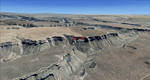
Mesa Verde National Park is famed for its numerous ruins of cliff dwellings built in the 12th century by ancient Pueblo people called Anasazi. Cliff dwellings are highly defensible stone villages situated under alcoves (rock overhangs) along the canyon walls. The largest cliff dwelling in the park is Cliff Palace, which is the largest cliff dwelling in North America. Cliff Palace contained 150 rooms and housed approximately 100 people. Unfortunately you won't see the cliff dwellings from the air, because they are under the cliffs but you will see everything else like all roads, trails and facilities. Very little is known about the Anasazis and the reason for their sudden departure at the end of the 13th century remains a mystery. Theories range from crop failures due to droughts to an intrusion of foreign tribes from the North. The name "Mesa Verde" stems from Spanish explorers seeking for a route from Sante Fe to California. They named the region Mesa Verde (spanish for green table) because of its high, tree-covered plateaus. High resolution versions of this scenery for FS9 and FSX (much sharper, but larger and multiple downloads)
are available at www.blueskyscenery.com/GNB_West2.html . The screenies are taken from the high-res versions, so expect this version to be slightly more blurry. Thanks to Joop Mak for providing custom AFCADs that correct airport layouts so that they align with the photo-textures! They are available at www.blueskyscenery.com/AFCADs.html . YourDonation@Work: Dedicated to David.
| Filename: | Mesa_Verde_National_Park_Cortez_KCEZ_Colorado_Phot.zip |
| License: | Freeware, limited distribution |
| Added: | 1st May 2010, 03:55:31 |
| Downloads: | 1,467 |
| Author: | Gottfried Razek - blueskyscenery.com |
| Size: | 92.87 MB |
| Category: Flight Simulator 2004 - Scenery | |
| Aspen (KASE), Colorado, Photo-Scenery (FS9 & FSX) |
|
Images related to this file:
File Description:
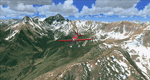
There sure is more than one reason to go to Aspen and this is sure another must-have of my Colorado sceneries. If you're coming IFR there's a couple of very demanding approach procedures. From a LOC/DME to several visual approaches there's everything your heart might desire. Due to the steep and high surrounding terrain these are quiet some hair raisers (see www.airnav.com/airport/KASE). If you're coming VFR then the traffic pattern altitude is 9.005 ft for light aircraft (vs. 9.505 for aircraft 12.500 lbs or more). Weather and wind permitting, RW15 is preferred for all landings (left pattern). RW33 has a right pattern and is preferred for all takeoffs. You even need a written permission to depart RW15. When departing VFR make a right turn to a heading of 360 degrees ASAP for noise abatement and hold this heading for at least 2 miles from the field. And don't forget to enjoy the impressive mountain scenery with two 14ers: Snowmass Mtn. and Castle Pk. to the southwest. This scenery brings you another 3.500 sq km of beautiful Colorado in 4.7m/pix quality. High resolution versions of this scenery for FS9 and FSX (much sharper, but larger and multiple downloads) are available at www.blueskyscenery.com/GNB_South2West2.html . The screenies are taken from the high-res versions, so expect this version to be slightly more blurry. YourDonation@Work: Dedicated to Mark, Markus and Yves.
| Filename: | Aspen_KASE_Colorado_PhotoScenery_FS9__FSX.zip |
| License: | Freeware, limited distribution |
| Added: | 30th January 2010, 17:04:55 |
| Downloads: | 3,578 |
| Author: | Gottfried Razek - blueskyscenery.com |
| Size: | 92.5 MB |
| Category: Flight Simulator 2004 - Scenery | |
| Squamish CYSE in British Columbia Canada |
|
Images related to this file:
File Description:
Squamish is a town with a population of just under 20,000, located at the northern end of Howe Sound where the Squamish River reaches the sea. Howe Sound is 25 miles deep and around 10 miles northwest of downtown Vancouver. It was for years based on the surrounding timber and a pulp mill, but with the closure of the saw and pulp mills now is more tourist oriented and the escape for Vancouver residents looking for (relative) peace and quiet. The runway is 2,400 feet of asphalt aligned 14-32. The buildings are built on differing levels of terrain, and the taxiways are sloped access ramps between the levels. This, of course, cannot be replicated in FS9, but it explains what at first sight appears to be a strange layout. The buildings are fairly well replicated. This is not an airport, it is an airfield meant for summer use as there is no lighting of any sort for runway or taxiways. The AI includes both GA and the helicopter flights by the two companies with bases at Squamish, Black Tusk and Blackcomb, the latter having several bases in this area with a HQ in Whistler. If you have the Vancouver scenery by FSAddon then you will need to move some of their bgl's aside; there are screenshots so that you can see which ones I have relocated. The UT settings are optional; I have been asked for my personal preferences. If you find a defect, email me.
| Filename: | Squamish_CYSE_in_British_Columbia_Canada.zip |
| License: | Freeware, limited distribution |
| Added: | 16th November 2020, 19:15:12 |
| Downloads: | 125 |
| Author: | Roger Wensley |
| Size: | 15.9 MB |
| Category: Flight Simulator 2004 - Scenery | |
| Bear Creek Winery & Lodging (v2.0.9) - "Diamond Edition" |
|
Images related to this file:
File Description:
Bear Creek Winery & Lodging Enhanced v2.0.9 "Diamond Edition".
An all new Flight Simulator experience awaits you at Bear Creek. This is a completely re-vamped "Extreme Make Over" of the previous Bear Creek Winery & Lodging. Some additions include: Scenery Changer Utility, Custom Textures, Festive Events (Christmas, Balloon Festival Etc.) Also added enhanced AI Traffic to the whole of Bear Creek. If you are a previous user of the original Bear Creek scenery this one that awaits you will indeed replace the original!!
No need to keep the previous version 1.0 that you may have downloaded this 2.0 version is a whole new interface that utilizes different install criteria.
Some of the Extra additions that are used with the new 2.0 version are: Runway12 3 Part Library, the Abacus Scenery Creator default libraries, Lago FSE, AI Schweizer 300C Helicopter, Gerrish Grey Tree Library Version 3. The direct links to these downloads are provided to you to download to display the scenery in its entirety. Not all of the above mentioned are required, like Lago, as it is a payware addition. All others mentioned are freely distributed at various download sites.
Please unzip (using folders option) to a temporary location and follow the installation instructions very carefully. Do not attempt to install this scenery with a "scenery manager" - for proper installation please use the built in installation routine.
Enjoy the newest edition: Airport Code: BCWL near Homer, Alaska.
| Filename: | Bear_Creek_Winery__Lodging_v209__Diamond_Edition.zip |
| License: | Freeware |
| Added: | 2nd February 2010, 10:50:06 |
| Downloads: | 4,947 |
| Author: | Mike Woolsey & David "Opa" Marshall |
| Size: | 58.49 MB |
| Category: Flight Simulator 2004 - Scenery | |
| CYQS - St Thomas - Ontario, Canada *V1* |
|
Images related to this file:
File Description:
St Thomas is a town in Ontario around 12 miles south of London and less than 10 miles from the north shore of Lake Erie, with a population of just under 40,000. The airport (actually more of an airfield, as there are no scheduled flights) has three runways typical of an ex-military field, with one remaining hangar from RCAF flight training times in the 1940's, and the east-west runway now extended to just over 5,000 feet. The main presence at CYQS is a company in the crop seeding and spraying business over a wide area of Ontario; as a result there are several AT-802 planes based there which are included here as AI planes and also as parked scenery objects. To the west of the original apron area there are added taxiways to cater for a herd of new individual hangars wearing orange and white uniforms. There is fuel, runway lighting on 09-27, taxiway lights, visitor parking on the edge of the apron, and maintenance companies in the large hangars, plus a flight training group. A small terminal building sits quietly between hangars, waiting. Ditches along the road and around much of the airfield provide separation, which is why the fences are not continuous. I presume that the warning balls on the electricity cables were found to be necessary to persuade pilots not to land there; probably ski planes in winter, they tend to land anywhere so long as it has snow on it. This V1 version includes previous updates.
| Filename: | CYQS__St_Thomas__Ontario_Canada_V1.zip |
| License: | Freeware, limited distribution |
| Added: | 30th August 2015, 02:35:28 |
| Downloads: | 265 |
| Author: | Roger Wensley |
| Size: | 11.13 MB |
| Category: Flight Simulator 2004 - Scenery | |
| Thompson CYTH in northern Manitoba, Canada |
|
Images related to this file:
File Description:
Thompson is a city with around 13,000 inhabitants, located in northern Manitoba beside the Burntwood River. It serves as the administration centre for a large area of Manitoba and has industrial activities centred around mining and the processing of mined products. The version of the airport upon which this modification is based is the original posting in 2004 by CanUK Scenery. I would have made new buildings and a totally new scenery but I have the same problem as Sid and Pete in their later Thompson scenery: almost no photos!?! The update modifies the short end of the mainly gravel runway to asphalt (it was upgraded because it is regularly used as a taxiway) and also adds a later (2010?) gravel taxiway. The other ground modifications add allocated parking spots for fire fighting CL415 planes that are in the new AI, plus a lot more ga parking. You should already have some AI that includes Calm Air to see CYTH as it really is, the HQ of Calm Air. There are other additions including car parks and the usual sundry bits and pieces that inhabit every airfield. The CL415's with Manitoba textures are adaptations of what were originally Ontario planes and included with my post of Geraldton, not the most recent post in 2013, the one in 2007. If you don't have the planes get them from my Geraldton post. The AI version was made from the original piloted version which was by Massimo Taccoli. The AI helicopter was included in my post of Alma CYTF.
| Filename: | Thompson_CYTH_in_northern_Manitoba_Canada.zip |
| License: | Freeware, limited distribution |
| Added: | 23rd September 2018, 15:24:22 |
| Downloads: | 223 |
| Author: | Roger Wensley |
| Size: | 6.4 MB |
| Category: Flight Simulator 2004 - Scenery | |
| CYVQ - Norman Wells - Northwest Territories, Canada |
|
Images related to this file:
File Description:
Norman Wells is the last of a series of airfields that are along (or close to) the Mackenzie River and in the Northwest Territories. It is 290 miles southeast of Inuvik and just 40 miles northwest of Tulita. The town growth was accelerated by the discovery of oil in the 1930's and the building of a small refinery in 1937, which is included here; there are now around 840 folks living in the town. The airport is adjacent to the town and has just under 6,000 feet of asphalt runway. North Wright Airways is headquartered there and this is reflected in the AI, which is for all of the newly-posted Mackenzie River postings. There is also helicopter AI, Canadian North, First Air, and there are GA flights. There is a mandatory frequency and the Norman Wells tower is manned 24 hours a day so you will follow atc instructions. In real life the terminal is on two levels; this steep change in terrain level is not possible to achieve in FS9 so although I made it as a two level terminal (ready for the FSX version?) it is here modified into a single level building. There are several "taxiways" which lead to the runway but are without hold short markings. These have been shown but are not included as AI routes. The helicopters presumably hover-taxi to the runway across grass (and snow) in real life; the AI helicopter will taxi on wheels. Note that at mixed-use airports planes and helicopters all follow the same rules of procedure.
| Filename: | CYVQ__Norman_Wells__Northwest_Territories_Canada.zip |
| License: | Freeware, limited distribution |
| Added: | 12th July 2014, 11:22:10 |
| Downloads: | 472 |
| Author: | Roger Wensley |
| Size: | 14.57 MB |
| Category: Flight Simulator 2004 - Scenery | |
| Deering PADE in Alaska |
|
Images related to this file:
File Description:
Deering is a coastal village around 55 miles southwest of Kotzebue, living from fishing and the land and with a population of around 130. The airfield is inland from the coast and has two gravel runways, 11-29 of just under 3,000 feet and 2-20 of 3,700 feet; the US is the only country that names runways with single numerals, hence 2-20 that in Canada would be 02-20. And Canada, which is a metric country and gives speed limits on roads in kilometres per hour, flies in feet and not metres for runway lengths and flight levels. The two runways could have something to do with there being a National Guard Armoury in the village, and perhaps personnel being flown in for exercises in the local countryside. Apart from the airfield itself, and it's buildings, this scenery modifies the local (mostly treeless) land class, reduces the village size to reality, and creates a new airfield background. Bering Air flies into Deering from Kotzebue and is included in the AI. A note here about my scenery making. This is post number 504 and there will not be many more to follow this as I am almost at the end of the photos I either took or found for scenery purposes. There is a limit to what can be located online and I have already been making use of the little there is; eg Unalakleet. So, if you are near an airport (preferably Canadian or Alaskan) and have a camera..... Let me know.
| Filename: | Deering_PADE_in_Alaska.zip |
| License: | Freeware, limited distribution |
| Added: | 7th August 2019, 16:37:12 |
| Downloads: | 137 |
| Author: | Roger Wensley |
| Size: | 4.32 MB |
© 2001-2026 AVSIM Online
All Rights Reserved
Privacy Policy |