
Where Flight Simulation Enthusiasts Gather from Around the World!
AVSIM Library - Search Results

| Category: Flight Simulator 2004 - Scenery | |
| FinneyGround_VERT_GSE for Rwy12 |

|
File Description:
This is a set of Ground Support Equiptment objects for Rwy12.
These objects were created in GMax and textured by Robert "Lt.Finney" Finnegan, and modified,grouped and formatted for Rwy12 by Gary "Gman" Mills.
These objects were custom made for use with the VERTva.com Base Sceneries so that our users could have some fun populating the VERT bases to give them some signs of activity. And of course they work well at any airport, and in some cases seaports, factories, heliports, etc.
For more information on VERTva Base sceneries, visit VERTva.com
This is #1 of 3 files
| Filename: | FinneyGround_VERT_GSE_for_Rwy12.zip |
| License: | Freeware, limited distribution |
| Added: | 17th September 2005, 00:36:55 |
| Downloads: | 8,212 |
| Author: | Robert Finnegan Gary Mills |
| Size: | 1.82 MB |
| Category: Flight Simulator 2004 - Scenery | |
| TropicalSim Cancun 2010 - Aftershave |
|
Images related to this file:
File Description:
A hand made shaving work over the TropicalSim-Cancun 2010 scenery for FS2004. This package contains these enhancements: New and improved terrain imagery with night textures, corrected runway headers for 12L/30R and 12R/30L, get rid of the default airport background image polygon, enchanced AFCAD which also includes the new ILS for runway 12L and the new VOR 'Nichupte', enchanced landclass and waterclass, added also windsocks, taxi signs, VOR and ILS antennas, a very realistic Cancun's peninsula, naval traffic* and additional enhancements for Lago FSE users*. Main requirement to install this patch: FS2004 (FS9.1) and TropicalSim MMUN 2010.
| Filename: | TropicalSim_Cancun_2010__Aftershave.zip |
| License: | Check within download |
| Added: | 3rd March 2010, 22:48:28 |
| Downloads: | 4,564 |
| Author: | Angel Salazar Estrada |
| Size: | 6.49 MB |
| Category: Flight Simulator 2004 - Scenery | |
| Scenic Cincinnati 2025 |
|
Images related to this file:
File Description:
This scenery package was created to spruce up the Ohio River valley in and around downtown Cincinnati as well as just across the Ohio River in Northern Kentucky. Over 60 unique buildings have been 3D designed, processed in MCX, and placed into FS9 as accurately as possible. Additionally, several default scenery buildings, such as the old Riverfront Stadium, have been removed and replaced with Paycor Stadium (Bengals) and Great American Ballpark (Reds).
The buildings have all been created to represent what you would normally observe while flying into the Greater Cincinnati – Northern Kentucky International Airport (KCVG). Some buildings contain more detail than others.
| Filename: | Scenic_Cincinnati_2025.zip |
| License: | Freeware, limited distribution |
| Added: | 12th March 2025, 15:28:43 |
| Downloads: | 205 |
| Author: | Michael Lehkamp |
| Size: | 26.24 MB |
| Category: Flight Simulator 2004 - Scenery | |
| CYPE - Peace River - Northwest Alberta, Canada |
|
Images related to this file:
File Description:
The Peace River flows east from the Rockies, joining up with the Slave River to empty into Great Slave Lake. The town is on both banks close to a bend, 245 miles northwest of Edmonton. The population is 7,000 and the surrounding area is either farmland or forest and used for winter sports; Peace River hosted the 2004 Alberta Winter Games. The airport is just over 3 miles west of the town. The runway is 5,000 feet of wide asphalt (150 feet) aligned 04/22, lit, and with PAPI. There is a second runway to the south of the main runway, 1,900 feet of grass and aligned 08/26. The apron is to the north of the runway at the eastern end and is large; there is a purpose-built terminal building, plus other hangar buildings along taxiway C that extends westward from the apron. The airport gives the impression that it is under-used; there are no long lines of parked planes waiting for the weekend and few scheduled flights. These are mainly (totally?) by Sunwest Home Aviation, but unfortunately nobody has made the textures for Sunwest and my talents do not run in that direction so I have made believable substitutions. There is also a small but obstinate AI difficulty, described in the notes.
| Filename: | CYPE__Peace_River__Northwest_Alberta_Canada.zip |
| License: | Freeware, limited distribution |
| Added: | 10th November 2013, 23:56:22 |
| Downloads: | 335 |
| Author: | Roger Wensley |
| Size: | 10.83 MB |
| Category: Flight Simulator 2004 - Scenery | |
| CYOC - Old Crow - Yukon Territory, Canada |
|
Images related to this file:
File Description:
Old Crow is in the far north of the Yukon Territory, Canada, 115 miles south of the nearest coastline and 30 miles east of the border with Alaska. The town has a population of less than 300 and the population are reliant on the caribou migration for an annual food supply replenishment. The fact that it is the only Yukon town that cannot be reached by car makes the airport important, and there are regular flights by Air North, the Yukon airline. They are included in the AI along with GA aircraft. I had several tries at matching up the Hawker Siddeley 748 with the right set of textures and I have included both here so that you do not have to go through the same torture. Thanks go to Hernan for sorting all that out, and for his textures. The airport is beside the town that is built along a bank of the Porcupine River. I have replicated the current shore line of the river that has cut a new channel at one end of the town, and I flattened the river as it was somewhat mountainous. The runway is gravel and just over 5,000 feet long, aligned 03-21. The terminal building is specific to Old Crow as I had photos, but the hangars are approximations and the village houses are only representational.
| Filename: | CYOC__Old_Crow__Yukon_Territory_Canada.zip |
| License: | Freeware, limited distribution |
| Added: | 5th December 2014, 13:31:46 |
| Downloads: | 378 |
| Author: | Roger Wensley |
| Size: | 7.58 MB |
| Category: Flight Simulator 2004 - Scenery | |
| Peace River CYPE in northwest Alberta, Canada UPDATED |
|
Images related to this file:
File Description:
This is an updated version of the original post (from 2014) made in November 2018. It provides missing textures, and deals properly with an ai problem that I thought I had already fixed. It also adds extra objects to the apron area and adds a third gate. It is complete in itself and can be installed as-is if you do not have the original post. The Peace River flows east from the Rockies, joining up with the Slave River to empty into Great Slave Lake. The town is on both banks close to a bend where the Peace turns to the north, 245 miles northwest of Edmonton. The population is 7,000 and the surrounding area is either farmland or forest. The airport is just over 3 miles west of the town. The runway is 5,000 feet of wide asphalt (150 feet) aligned 04/22, lit, and with PAPI. There is a second runway to the south of the main runway, 1,900 feet of grass and aligned 08/26. The apron is to the north of the runway at the eastern end and is large; there is a purpose-built terminal building, plus other hangar buildings along taxiway C that extends westward from the apron. The airport is experiencing an increase in scheduled and GA flights in the last few years.
| Filename: | Peace_River_CYPE_in_northwest_Alberta_Canada_UPDAT.zip |
| License: | Freeware, limited distribution |
| Added: | 10th December 2018, 17:33:25 |
| Downloads: | 128 |
| Author: | Roger Wensley |
| Size: | 24.27 MB |
| Category: Flight Simulator 2004 - Scenery | |
| Terrace CYXT Updated |
|
Images related to this file:
File Description:
This revises the previous versions by adding two missing buildings, corrects the apron markings and parking and adds a third gate, creates more GA parking, updates the AI to include, for instance, a Westjet flight, and most importantly of all adds the ILS to runway 33. It is complete in itself and can be installed as-is without first installing previous versions. Terrace is fifteen miles east and inland from Prince Rupert, which is 500 miles north of Vancouver up the BC coast. It is at the point in the mountains where two fjords meet, one coming from Prince Rupert and the other from Kitimat. The population of the town is around 12,500. The airport is called Terrace-Kitimat and is a couple of miles south of the town of Terrace, on the south side of the Skeena River. There are two runways, and the main one is a recently-extended 7,500 feet long and lit 33-15 with approach lighting to both ends and an ILS on 33. The second is 5,373 feet of unlit 03-21. The apron has been enlarged to be able to accommodate a Boeing 737, though there is at the moment no airline using a 737 for flights to Terrace. The pics and the video show the surrounding hilly terrain and the nearby river between the airport and the town.
| Filename: | Terrace_CYXT_Updated.zip |
| License: | Freeware, limited distribution |
| Added: | 13th January 2019, 18:38:12 |
| Downloads: | 178 |
| Author: | Roger Wensley |
| Size: | 15.64 MB |
| Category: Flight Simulator 2004 - Scenery | |
| Z19O - Hamat Airbase - Batroun, Lebanon |
|
Images related to this file:
File Description:
Hamat is a village near the coast of Lebanon, around 25 miles north of Beirut. The airport runway was built during the civil war to the west of Hamat in the late 1970's, between Hamat and another village called Wuajh Al Hajar. The intention was have an alternative to Beirut airport, which could be (and often was) closed by shell fire from any or all of the sides involved in the civil war, or by bombing by those who were not directly part of the civil war but occasionally joined in. It has been used for drag racing, occasional freefall parachuting (this may continue) and is now an army base with mostly helicopter use. The runway is around 5,600 feet of asphalt, 90 feet wide and aligned 02/20. There is no lighting. The apron is set well back from the runway and has hangars at each end; one set is four hangars long, and at the other end of the apron there are three hangars. There are also the remains of some radar to the west of the apron, bombed (in 1982?). The runway has been repositioned and the surrounding landclass modified to reduce one village to it's approximate actual size and to create a second village which was missing entirely. An intrusive road has been deleted, and the airfield grass area also modified.
| Filename: | Z19O__Hamat_Airbase__Batroun_Lebanon.zip |
| License: | Freeware, limited distribution |
| Added: | 23rd May 2015, 10:03:10 |
| Downloads: | 226 |
| Author: | Roger Wensley |
| Size: | 8.53 MB |
| Category: Flight Simulator 2004 - Scenery | |
| Lake Powell - Bullfrog Basin (U07), Utah, Photo-Scenery (FS9 & FSX) |
|
Images related to this file:
File Description:
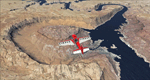
This scenery covers the area from the southern end of the Waterpocket Fold down to the Bullfrog Basin and the eastern end of the Kiaparowits Plateau. It extends my Canyonlands sceneries to the southwest and brings you another 3.500 sq km in 4.7m/pix quality. To explore the scenery depart from Bullfrog Basin Airport (U07) and west. High resolution versions of this scenery for FS9 and FSX (much sharper, but larger and multiple downloads)
are available at www.blueskyscenery.com/CNY_South2West2.html . The screenies are taken from the high-res versions, so expect this version to be slightly more blurry. YourDonation@Work: Dedicated to Jean-Marc, Jim and Cay.
| Filename: | Lake_Powell__Bullfrog_Basin_U07_Utah_PhotoScenery_.zip |
| License: | Freeware, limited distribution |
| Added: | 18th January 2010, 19:27:52 |
| Downloads: | 1,602 |
| Author: | Gottfried Razek - blueskyscenery.com |
| Size: | 92.83 MB |
| Category: Flight Simulator 2004 - Scenery | |
| Los Cabos SJD / MMSD |
|
Images related to this file:
File Description:

This is a complete remake of the Los Cabos Int'l Airport in Cabo San Lucas/ San Jose Del Cabo. All terminal buildings have been replaced and repositioned to be more accurate. All parking is accurate per the SJD website and other online sources. There is a
fictional parallel taxiway to the south end of the runway which is under construction in real life. There has been significant enhancement to the beach resort area along the coastline which makes the approach a little more realistic. Also included in this download is a must-have landclass file by Alfredo Hernandez that adds much needed civilization to the area.
| Filename: | Los_Cabos_SJD__MMSD.zip |
| License: | Freeware |
| Added: | 5th September 2010, 11:11:41 |
| Downloads: | 1,631 |
| Author: | William Morgan, FRFStudio.net |
| Size: | 9.75 MB |


© 2001-2026 AVSIM Online
All Rights Reserved
Privacy Policy |