
Where Flight Simulation Enthusiasts Gather from Around the World!
AVSIM Library - Search Results

| Category: Flight Simulator 2004 - Scenery | |
| KPQI Presque Isle (1942-1945) |

|
File Description:
Situated very near the Canadian border, this airport in Maine played a major role in ferrying US aircraft to the United Kingdom during the Second World War, in conjunction with, among others, Montreal (CYUL), Goose Bay (CYYR), Gander (CYQX) in Newfoundland and Bluie West One (BGBW) in southern Greenland. Ernest K Gann operated from it in 1942 and it therefore features in his classic 'Fate is the Hunter'. With an ADE drawn on a chart of 1956 and some custom buildings, this scenery attempts to recreate this historic airfield.
| Filename: | KPQI_Presque_Isle_19421945.zip |
| License: | Freeware, limited distribution |
| Added: | 20th February 2026, 21:00:18 |
| Downloads: | 35 |
| Author: | Ken Lawson |
| Size: | 17.12 MB |
| Category: Flight Simulator 2004 - Scenery | |
| Laconia, New Hampshire - KLCI - lake elevation correction |
|
File Description:
Runway 8 at the Laconia, New Hampshire - KLCI - is situated quite close to a lake. The elevation of the lake in FS2004 is such that it presents a "cliff" of water in the default setting. (see "before" screenshot). This package contains a simple flatten file which brings the lake down to the elevation of the airport and corrects a floating building issue also (see "after" screenshot). Please unzip to a temporary folder and follow the very simple installation instructions. Created with Steve Greenwood's FSTflatten program by David "Opa" Marshall for your flying enjoyment.
| Filename: | Laconia_New_Hampshire__KLCI__lake_elevation_correc.zip |
| License: | Freeware |
| Added: | 20th November 2008, 02:27:08 |
| Downloads: | 595 |
| Author: | David "Opa" Marshall |
| Size: | 116.12 KB |
| Category: Flight Simulator 2004 - Scenery | |
| Scenery Fuerstenfeldbruck - Airbase ETSF (Germany) Vers. 2 |
|
File Description:
This is the second version of the also by general aviation used Airbase ETSF "Fürsty" in southern Germany.
This new version includes:
» completely new designed hangars, some of them with controllable hangardoors.
» a new controll-tower.
» the buildings of the official school for the German Air Force.
» interactive air-marshallers.
» an improved airport-layout.
» the radio-tower of Schoengeising as a landmark for VFR-Flights.
» an exact landclassfile for the surroundings of the airbase.
It also includes some GA-AI-Traffic.
Compatible with MyWorld2004-Landclass and Werner Vogts "SRTM scenery mesh".
| Filename: | Scenery_Fuerstenfeldbruck__Airbase_ETSF_Germany_Ve.zip |
| License: | Freeware, limited distribution |
| Added: | 11th June 2004, 19:54:39 |
| Downloads: | 7,687 |
| Author: | Johannes Oelmaier |
| Size: | 2.53 MB |
| Category: Flight Simulator 2004 - Scenery | |
| CH-Pro Autogen for the region of Zurich |
|
File Description:
The folder you just downloaded contains 435 so called AGN files. These do cover the whole area (inkl. Zurich Airport) of the biggest city in Switzerland: Zurich.
Note that this will be a unique upload and we don’t intend to release any additional files on sites like Avsim or Flightsim in the future.
As a consequence you might, if you want some Autogen for some other regions of Switzerland (and Germany), have a look on our website where Autogen for almost half of Switzerland (and much more) is available for download. See Readme for Details.
| Filename: | CHPro_Autogen_for_the_region_of_Zurich.zip |
| License: | Freeware, limited distribution |
| Added: | 2nd June 2006, 02:58:51 |
| Downloads: | 6,965 |
| Author: | Lukas Kaufmann, CH-Pro Autogen Team |
| Size: | 1.87 MB |
| Category: Flight Simulator 2004 - Scenery | |
| Cape Verde Islands Domestic Airports |
|
Images related to this file:
File Description:
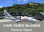
Googlyafcads and simple scenery for five airports in the Cape Verde Islands, all
of which are served by regular domestic flights of TACV - Transportes Aereos de
Cabo Verde. Each of these has been "overlooked" by Microsoft in Flight Simulator
2004 and are provided with nothing other than a runway. These scenery files add
aprons, taxiways, buildings and other airport features to Flight Simulator's bland
representation and allow you and "AI" traffic to land, taxi, park and take off
in a realistic manner.
The airports represented are: GVBA Rabil, GVMA Maio, GVSF Sao Filipe, GVSN Preguica and GVSV Sao Pedro.
The scenery does not purport to be ultra-accurate. Based on high-detail satellite
imagery from Google Earth (except Sao Filipe), the layout is proportianally correct
but the added airport features, such as buildings, are built from default Microsoft
objects and add-on libraries so will not look like the real thing. Sao Filipe is
largely imaginary owing to poor quality of the satellite image, but has been created
to be similar to other airports of like size.
You are not obliged to download and install any additional scenery libraries,
but to enjoy this scenery in its entirety, you may wish to. It will work fine,
with or without.
[File re-uploaded at request of AVSIM]
| Filename: | Cape_Verde_Islands_Domestic_Airports.zip |
| License: | Freeware |
| Added: | 15th June 2010, 01:00:46 |
| Downloads: | 7,007 |
| Author: | John Hinson |
| Size: | 84.1 KB |
| Category: Flight Simulator 2004 - Scenery | |
| Fort Liard CYJF in the Northwest Territories, Canada |
|
Images related to this file:
File Description:
Fort Liard is the seventh in a series of airfields that follow (approximately) the Mackenzie River. At the far northern end of the river there is Tuktoyaktuk, then Inuvik, Fort McPherson, Fort Good Hope, Deline, Wrigley, and then Fort Simpson Island and Fort Simpson, all posted. Fort Liard is at 708 feet asl and on the east bank of the the Liard River, around 130 miles south of Fort Simpson where the Liard and Mackenzie join, and about 25 miles from the borders with both British Columbia and the Yukon. The town has a population of about 560 folks.
The airport is next to the town, and has almost 3,000 feet of gravel runway. I have no information regarding when it was built but it may be from the WW2 time; the cleared and grassed area is long enough for a runway 0f 6,000 feet. There are no scheduled flights but North Cariboo Air have a base at the airport for local charters to support survey teams etc. and are almost an on-demand-scheduled airline. I have also added a Buffalo DC3 and GA. There is fuel available, but only by prior arrangement with North Cariboo. Right hand circuits for runway 20.
| Filename: | Fort_Liard_CYJF_in_the_Northwest_Territories_Canad.zip |
| License: | Freeware, limited distribution |
| Added: | 11th July 2014, 13:38:49 |
| Downloads: | 304 |
| Author: | Roger Wensley |
| Size: | 10.07 MB |
| Category: Flight Simulator 2004 - Scenery | |
| Trail CAD4 in British Columbia, Canada |
|
Images related to this file:
File Description:
Trail is in the valley carved out by the Columbia River, around 7 miles north of the Canada-US border and on both banks of the river. The town has a population of just under 8,000 and the main industry is mining. The airport is around 3 miles south-east of the town and on the east bank, with the runway parallel to the river and aligned 16-34, 75 feet wide and asphalt. There are currently no runway or taxiway lights, though there is an overall improvement programme in place to cope with increasing passenger demand. A new terminal building was recently completed, along with alterations to road access and parking; as I have no information regarding these road changes I have left the original "terminal" building in place and in use by Pacific Coastal, the only airline to fly to Trail. There is a Youtube video which gives a very good idea of the basic facilities, and of the surrounding hilly terrain which is similar to that at Bella Cooola at the far side of Pacific Coastal's coverage area. The original position of the airport in FS9 before I corrected it was best described as "in a hole". The hole remains nearby as there is no easy way to deal with it.
| Filename: | Trail_CAD4_in_British_Columbia_Canada.zip |
| License: | Freeware, limited distribution |
| Added: | 23rd December 2018, 17:27:38 |
| Downloads: | 143 |
| Author: | Roger Wensley |
| Size: | 12.3 MB |
| Category: Flight Simulator 2004 - Scenery | |
| Boise Air Terminal |
|
File Description:
This is my first release of Boise Air Terminal in Boise, Idaho. This scenery was created for FS2004, and will not work with earlier versions. It completely replaces the terminal and concourse areas, most of the GA and freight areas on the north side, and most of the Air Guard areas on the south side. The SW GA areas remain default. It's based on extensive photos of the airport, and most of the added objects are near photo-real. It was created completely with GMax and .xml coding, so the frame rate hit will be minimal if any at all.
| Filename: | Boise_Air_Terminal.zip |
| License: | Freeware, limited distribution |
| Added: | 13th January 2006, 17:25:44 |
| Downloads: | 8,941 |
| Author: | Gary Widup |
| Size: | 1.76 MB |
| Category: Flight Simulator 2004 - Scenery | |
| Budd Lake Airfield |
|
File Description:
FS2004 Scenery - This is another retro scenery I found interesting enough to design for your flying enjoyment.Budd Lake Airfield,Budd Lake, NJ was apparently opened at some point between 1945-49, as it was not depicted at all on the 1945 NY Sectional Chart nor on the 1947 USGS topo map.
The earliest depiction of the airfield which has been located was on the 1949 NY Sectional Chart. The airport began business shortly after WW2. The property owner's son wanted a place close to home where he could learn to fly & keep his airplane. Created with Instant Scenery by John B. Loney, Jr.
| Filename: | Budd_Lake_Airfield.zip |
| License: | Freeware, limited distribution |
| Added: | 2nd January 2009, 01:54:04 |
| Downloads: | 235 |
| Author: | John B. Loney, Jr. |
| Size: | 2.82 MB |
| Category: Flight Simulator 2004 - Scenery | |
| Salbani, India |
|
File Description:
You will need to download the original MCDMil.zip package by Michael Carr in order to use the MCD textures.
Based on 356 Squadron Salbani WW2 airport, India. A contemporary rendition. Yep, the main runway is just long enough for the Liberator to take off. There's even a camp cinema, (at night-time, you will see my Dad in the projection box). Developed mainly for eye-candy....oh and you must fly to the nearby camp, (but be careful of those tanks on the practice-range). I've placed a heli runway at the camp for AI purposes.
| Filename: | Salbani_India.zip |
| License: | Freeware, limited distribution |
| Added: | 12th February 2009, 21:01:00 |
| Downloads: | 337 |
| Author: | Godfrey Tier |
| Size: | 2.01 MB |


© 2001-2026 AVSIM Online
All Rights Reserved
Privacy Policy |