
Where Flight Simulation Enthusiasts Gather from Around the World!
AVSIM Library - Search Results

| Category: Flight Simulator 2004 - Scenery | |
| Valle D'Aosta part 2 (West), Alps, Italy, Photo Real |

|
Images related to this file:
File Description:
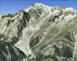
The scenery covers the western portion of the Valle D'Aosta, North Italy, Alps. The Photo Real Scenery is wide for around 2100 squared Kms. The airport of Aosta (ICAO code LIMW) is found inside the scenery (see map). The complete scenery of the valley was divided in 2 parts to fit the 100Mb file space limit: part 2 (this file) and part 1 (est side see AVSIM library - valle_aosta_est_vfr.zip). For FSX and FS9.
| Filename: | Valle_DAosta_part_2_West_Alps_Italy_Photo_Real.zip |
| License: | Freeware |
| Added: | 2nd June 2010, 13:22:39 |
| Downloads: | 14,697 |
| Author: | Fulvio Mazzokan |
| Size: | 58.15 MB |
| Category: Flight Simulator 2004 - Scenery | |
| Hamburg 2003, v1.1 |
|
Images related to this file:
File Description:
FS2002/FS2004 High detailed scenery. The Hamburg-City-Scenery Version 1.1 covers the Area of Hamburg (Germany) and the surrounding. Includes a Jeppesen VFR-Chart of that area. (No Airport-Scenery).
The Scenery is specially made for VFR-flying but also to use for IFR. More than 70 buildings, ships and other landmarks like the huge harbor will show you the beautiful city of Hamburg in the north of Germany. (CJ)
| Filename: | Hamburg_2003_v11.zip |
| License: | Freeware |
| Added: | 7th June 2010, 21:17:11 |
| Downloads: | 17,077 |
| Author: | Dirk Brandenburg |
| Size: | 12.69 MB |
| Category: Flight Simulator 2004 - Scenery | |
| Arches National Park, Moab (KCNY), Utah, Photo-Scenery (FSX too) |
|
File Description:
This scenery covers another beautiful National Park: Arches National Park near Moab in Utah. It contains the park itself, Moab, the La Sal Moutains and the northern part of Canyonlands National Park, which will be covered in an upcoming package. The total area is 3.500 sq km and comes in 4.7m/pix quality. To explore the scenery depart from Canyonlands Field Airport (KCNY) and head south. YourDonation@Work: Dedicated to Hector, William and Jerald. Thanks!
| Filename: | Arches_National_Park_Moab_KCNY_Utah_PhotoScenery_F.zip |
| License: | Freeware, limited distribution |
| Added: | 5th January 2009, 19:31:11 |
| Downloads: | 3,710 |
| Author: | Gottfried Razek - www.blueskyscenery.com |
| Size: | 94.68 MB |
| Category: Flight Simulator 2004 - Scenery | |
| Lost Cities in FS2004 - City Of Malta And It's Surrounding Villages |
|
File Description:
This is a land class for the island of Malta. In FS2004 many cities do not exist. One of them is the city of Malta and it's surrounding villages. With this file the island of Malta is not an island without villages and cities anymore (as it is in FS2004). Now it is an island with villages surrounding the airport of Malta (as in reality) and of course the capital, the city of Malta!
| Filename: | Lost_Cities_in_FS2004__City_Of_Malta_And_Its_Surro.zip |
| License: | Freeware |
| Added: | 24th July 2008, 00:09:55 |
| Downloads: | 4,178 |
| Author: | Dave Sheffield |
| Size: | 112.13 KB |
| Category: Flight Simulator 2004 - Scenery | |
| Lost Cities in FS2004: Cities & Towns Of Island |
|
File Description:
Lost Cities in FS2004: Island - Keflavik & Co
In the default scenery of FS2004 many Cities do not exist. This time I represent you the follwoing lost towns of Island
in the near of Keflavik Airport, including: Keflavik, Byjarsker, Vogar, Grinfavik, Njardhvikur and more.
Also pay attention to my other files by Dave Sheffield:
Lost Cities of Malta
Real Landclass of Nürnberg
Real Landclass of Dublin incl. the Town of Swords
Real Landclass of Manchester
| Filename: | Lost_Cities_in_FS2004_Cities__Towns_Of_Island.zip |
| License: | Freeware |
| Added: | 31st August 2008, 22:52:45 |
| Downloads: | 2,615 |
| Author: | Dave Sheffield |
| Size: | 6.15 KB |
| Category: Flight Simulator 2004 - Scenery | |
| LFSB EuroAirport Basel Mulhouse Freiburg (EAP), Release 01 |
|
File Description:
The Euroairport Basel Mulhouse Freiburg LFSB, Release 01.
Finished 14.01.2006, tested with Win XP on FS2004.
This is the first Final-Release of the EAP LFSB after the Pre-Release in 2004.
This is a Swiss/French Airport at the border of Germany, France and Switzerland on French territoriy. Includes Y-Terminal, General Aviation Area, Freight Area and new Swiss- /Novartis Hangars. Even some buildings are not designed in GMAX, framerates are good. Happy Landing.
| Filename: | LFSB_EuroAirport_Basel_Mulhouse_Freiburg_EAP_Relea.zip |
| License: | Freeware |
| Added: | 15th January 2006, 20:34:21 |
| Downloads: | 39,527 |
| Author: | Joerg Unglaub |
| Size: | 6.5 MB |
| Category: Flight Simulator 2004 - Scenery | |
| Port Hardy CYZT in British Columbia, Canada |
|
Images related to this file:
File Description:
Port Hardy airport is on the coast of Vancouver Island in BC, at the far northern end and 5 miles east of the town. The town and the airport are both gateways to local touristic attractions such as Cape Scott Provincial Park, the North Coast and BC Marine Trails, and kayaking, caving, surfing, fishing, camping, and scuba diving (and I discovered just how big orca are). Fishing, logging, and mining have been important and to an extent still are for the town population of just over 4,000. The airport, along with the ferries, connects Port Hardy to the rest of the west coast with Pacific Coastal Saab 340 or Beechcraft 1900C flights to and from Vancouver at least twice a day. There are also Grumman Goose amphibious flights to local float bases such as Port McNeill, Alert Bay, Whaletown, Surge Narrows, Echo Bay, and Minstrel Island. These are all included in the AI and previously posted. There are three runways: 11-29 of 5,000 feet with ILS on 11 and righthand circuits on 29, 07-25 of 4,000 feet with righthand circuits on 25, and 16-34 with a much shortened 3,500 feet on 34 due to a displaced threshold. There is a control tower but it is not manned 24 hours a day; a "mandatory frequency" (MF for short and a Canadian invention) is used by the tower when it is manned, and when there is no tower response the aircraft continues to announce intentions and position. Something I have been meaning to explain to those who query it, is that in real life as well as in FS9 helicopters at a mixed use airport or airfield will act as if they are planes and join downwind, turn on base and then finals, "land" along the runway and then use the taxiway to the parking. This means all aircraft are doing the same thing and an orderly queue avoids collisions. This is one of a series connected in some way with Pacific Coastal airline destinations, the first being Bella Coola. There is AI available for Pacific Coastal online.
| Filename: | Port_Hardy_CYZT_in_British_Columbia_Canada.zip |
| License: | Freeware, limited distribution |
| Added: | 11th November 2018, 16:48:50 |
| Downloads: | 234 |
| Author: | Roger Wensley |
| Size: | 19.26 MB |
| Category: Flight Simulator 2004 - Scenery | |
| Cameri and Turbigo sceneries (rev. 3) - north Italy |
|
Images related to this file:
File Description:
The following files are required by this file:
http://library.avsim.net/esearch.php?DLID=163723&UploadID=&Name=&FileName=&Author=&CatID=root
http://library.avsim.net/esearch.php?DLID=186350&UploadID=&Name=&FileName=&Author=&CatID=root
This scenery includes a global review of the previous Sceneries of Cameri Military airport (rev.2 Oct 2011), Cameri Museum (rev. 2 Oct 2011), Cameri Babini (rev. 2 oct 2011), Turbigo power station (rev. 2 Sep 2011 and update rev. 2.1 Oct 2014). All the above ARE NOW INCLUDED in this new unique scenery. Contents: Terrain in new version photo-realistic multi-seasons/night; adapted to Western Europe special elevation meshes; cover area of over 120 sqkm from Bellinzago-Oleggio (NW) to Magnago-Bienate (NE), from Novara (SW) to Cuggiono-Inveruno (SE); all the terrain has been restorated with 3D buildings, either through autogen that with specific dedicated objects (by GMax) and with significant addition of library objects ("dva51" and other existings). This scenery (located on the final approach to the Milan Malpensa international airport) includes the Cameri's Mil Airport with the Babini closed Army area and the planes of the Historical Museum of the airport; it is also included the thermoelectric power station of Turbigo. All the buildings are placed to recreate cities and villages covered in the photo-realistic terrain, including Bellinzago, Bienate, Buscate, Caltignaga, Cameri, Castano Primo, Castelletto Ticino, Cuggiono, Galliate, Inveruno, Magnago, Malvaglio, Nibbia, Novara, Oleggio, Pernate, Robecchetto, Romentino, Sant'Anna, San Pietro Mosezzo, Turbigo , Vanzaghello, and the covered Turin-Milan highway.
Details of the new buildings for the care and maintenance to F35 completely recreated, as obtainable from the current satellite view.
It REQUIRES the use of the following, to be downloaded separately :
- the libraries dva51 - the system of vegetations TreePlanter - the West Europe Meshes of Daniele Lanfranchi. See the Readme file. Enjoy!
Videos available here:
https://dl.dropboxusercontent.com/u/38829151/FS9/Cameri_Turbigo_v3%20shots.WMV
http://youtu.be/yVI2KeJKS5o
http://youtu.be/oKa0e_5kxIk
| Filename: | Cameri_and_Turbigo_sceneries_rev_3__north_Italy.zip |
| License: | Freeware |
| Added: | 21st January 2015, 21:32:36 |
| Downloads: | 992 |
| Author: | Aldo Della Vedova, Daniele Lanfranchi and Gian Mario Verga |
| Size: | 103.7 MB |
| Category: Flight Simulator 2004 - Scenery | |
| Seamans Field 9N3 Pa |
|
File Description:
Seamans Field (9N3) is located in the a little north of Factoryville, Pa. Many costom macros were created (using fsds2) for this project. Some of the features include: windsock, beacon, many hangars, many, many trees, the addition of Lake Sheridan (off the end of runway 4). Also included is a custom AFCAD2 file to allow AI traffic at the airport as well as AI aircraft (default and added). Requires Gerrish Greys's tree macros to be installed (trees_v3.zip)
| Filename: | Seamans_Field_9N3_Pa.zip |
| License: | Freeware |
| Added: | 30th June 2004, 04:58:18 |
| Downloads: | 1,688 |
| Author: | Phil Cruikshank |
| Size: | 3.06 MB |
| Category: Flight Simulator 2004 - Scenery | |
| JRM Bahamas EZ Scenery #2 Highly detailed JRM_Bhm2 |
|
File Description:
FS9+ scenery Eleutheria Island JRM_Bhm2.zip (see JRM_bhm1.zip)
This scenery utilizes FS Global Terrain Mesh and GroundEnv-1.
All objects are available by download linked inside. Payware
expected detail in which you can even motorcar on sightseeing trips
stopping and watching all the eye candy. This scenery fills up through
Rock Sound airport while
adding tower and ground to CJCR.
FS9 & FS10
only. My best yet and more to come!
jimmy R martin
[email protected]
John 3:16
| Filename: | JRM_Bahamas_EZ_Scenery_2_Highly_detailed__JRM_Bhm2.zip |
| License: | Freeware |
| Added: | 23rd March 2006, 03:42:20 |
| Downloads: | 2,227 |
| Author: | jimmy R martin |
| Size: | 72.54 KB |
© 2001-2026 AVSIM Online
All Rights Reserved
Privacy Policy |