
Where Flight Simulation Enthusiasts Gather from Around the World!
AVSIM Library - Search Results

| Category: Flight Simulator 2004 - Scenery | |
| Boischâtel Airstrip and Scenery, === Québec Short Hops |

|
File Description:
Boischâtel is a (fictitious) grass strip by the St. Lawrence River a few miles downstream from Québec City facing beautiful Île d'Orléans. It also has a dock for seaplanes. Taking off at night you will see the magnificient Château Frontenac and animated fireworks with detonations. Heading due East, you should see Ste Anne Basilica. Those other sceneries are the creations of André Côté and Michel Baron. Details to get the files in the download. This scenery, though not tested, should work in FS2002 also.
| Filename: | Boischtel_Airstrip_and_Scenery__Qubec_Short_Hops.zip |
| License: | Freeware |
| Added: | 6th January 2004, 20:29:32 |
| Downloads: | 2,519 |
| Author: | Léon Louis |
| Size: | 4.14 MB |
| Category: Flight Simulator 2004 - Scenery | |
| Breezeway-Update |
|
File Description:
For those who might have had issues with frame rates with Breezeway.zip, this should take care of it. A few items have been removed and the terminal is somewhat smaller. The file that takes care of this is Breezeway.bgl. Breezeway.BGL is for static object library in case someone missed it. There is also a nice FSE LAGO file showing a truck driving home from the airport. save the old breezeway.bgl in case you want to return to the original file. Breezeway.zip is needed for this update. Bob
| Filename: | BreezewayUpdate.zip |
| License: | Freeware |
| Added: | 2nd June 2006, 03:03:44 |
| Downloads: | 426 |
| Author: | Robert Lacy |
| Size: | 356.22 KB |
| Category: Flight Simulator 2004 - Scenery | |
| CVN-65 off Puerto Rico |
|
File Description:
An officially-sanctioned freeware demo of AlphaSim's USS Enterprise (CVN-65). It includes the full USS Enterprise Model, a full texture set for the ship, and one location near Puerto Rico with a "hard surface" to land on. The Full Release version available from AlphaSim has 10 locations worldwide, plus all carriers come with multiple "Deck Set-ups" including A-6, F-14, and S-3 "static" aircraft. The full package also includes AI flights and AFCADS using the three provided AI aircraft types.
| Filename: | CVN65_off_Puerto_Rico.zip |
| License: | Commercial demo |
| Added: | 21st March 2006, 01:47:47 |
| Downloads: | 9,773 |
| Author: | Alphasim |
| Size: | 9.09 MB |
| Category: Flight Simulator 2004 - Scenery | |
| FQIA - Inhaca Airport - Maputo Province, Mozambique |
|
Images related to this file:
File Description:

A Gmax representation of Inhaca Airport (FQIA), Inhaca Island, Mozambique with photoreal textures.
Inhaca island is a small island situated about 32 km east of Maputo, the capital of Mozambique. Transairways provide daily flights from Maputo airport to Inhaca airport, typically with smaller (18 seat) aircraft and the flight lasts no more than about 15 minutes.
The airport consist of a very small terminal building and two runways. Runway 18/36 (asphalt) measuring 650m and runway 10/28 (grass) which also measures 650m.
| Filename: | FQIA__Inhaca_Airport__Maputo_Province_Mozambique.zip |
| License: | Freeware, limited distribution |
| Added: | 12th September 2015, 00:12:07 |
| Downloads: | 360 |
| Author: | Kobus van Wyk, Aeroworx |
| Size: | 1.25 MB |
| Category: Flight Simulator 2004 - Scenery | |
| Thames Estuary Airport, London (concept) |
|
Images related to this file:
File Description:
Thames estuary airport is a possible new feature to the compilation of UK airports. Using the concept images on the net, we have made the airport for FS9. Please note that this is a very large airport and may not be suitable for slower computers.
There have been plans since 1943 to build a new airport for London at various locations around the Thames Estuary. The proposal was revived in 2008 by the Mayor of London, Boris Johnson, and has acquired the nickname "Boris Island".
| Filename: | Thames_Estuary_Airport_London_concept.zip |
| License: | Freeware |
| Added: | 6th August 2012, 18:26:11 |
| Downloads: | 268 |
| Author: | Soarfly Concepts |
| Size: | 437.83 KB |
| Category: Flight Simulator 2004 - Scenery | |
| ALSACE VFR Version 2 |
|
File Description:
Alsace is a wunderfull region in Eastern France, located near the Rhine river, between the Vosges in France and the Black Forest in Germany. Alsace VFR allows you to make VFR flights above this pleasant region. Included in this package are the airfields of Strasbourg-Entzheim (LFST), Basle-Mulhouse (LFSB), Mulhouse-Habsheim (LFGB), Strasbourg-Neuhof (LFGC), Sarreguemines (LFGU), Sarre-Union (LFQU), Haguenau (LFSH) and Colmar-Meyenheim AB (LFSC).
Also included are many VFR refpoints. In this package are also included : a Landclass and a few flights.
| Filename: | ALSACE_VFR_Version_2.zip |
| License: | Freeware, limited distribution |
| Added: | 8th April 2004, 23:20:53 |
| Downloads: | 21,461 |
| Author: | The HAAL Design Team (R.Stuck, R.Chauvin, P.Bantzhaff...) |
| Size: | 17.22 MB |
| Category: Flight Simulator 2004 - Scenery | |
| FASZ - Skukuza Airport - Mpumalanga, South Africa |
|
Images related to this file:
File Description:
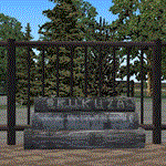
A Gmax representation of Skukuza Airport (FASZ), Kruger National Park, Mpumalanga, South Africa with photoreal textures.
Skukuza airport is situated inside the Kruger National Park and is served twice daily by commercial flights form Johannesburg and once a day by a commercial flight from Cape Town (operated by Airlink).
Located in close proximity to Skukuza main camp and the adjoining Sabi Sand Conservancy, the airport is unique in providing direct access into one of the world's largest protected wildlife areas.
| Filename: | FASZ__Skukuza_Airport__Mpumalanga_South_Africa.zip |
| License: | Freeware, limited distribution |
| Added: | 19th September 2014, 08:50:51 |
| Downloads: | 916 |
| Author: | Kobus van Wyk, Aeroworx |
| Size: | 4.35 MB |
| Category: Flight Simulator 2004 - Scenery | |
| Lapangan Terbang Sultan Abdul Halim, Alor Star (WMKA) |
|
File Description:
This is a representation of the Sultan Abdul Halim Airport Alor star, The airport, located 15 km away from town (Alor Star). Alor Star is the state capital of Kedah, Malaysia. It is located 93 kilometers north of Butterworth, Penang on the main road to the border with Thailand. The city serves a distribution center for manufacturing and agricultural products and as a transportation hub in the upper north. The new terminal is expected to be ready by end 2005 to cater for future traffic growth.
| Filename: | Lapangan_Terbang_Sultan_Abdul_Halim_Alor_Star_WMKA.zip |
| License: | Freeware |
| Added: | 25th August 2005, 15:34:19 |
| Downloads: | 4,540 |
| Author: | Mohammad Ibrahim Rahmat |
| Size: | 2.36 MB |
| Category: Flight Simulator 2004 - Scenery | |
| San Antonio International Airport 'KSAT' |
|
File Description:
This scenery is built for FS2004. This scenery was created with Abacus EZ Scenery, but you do not need the EZS libraries. On the contrary you will need the RWY12 libraries installed. I have added a terminal replacement, airport vehicles, parking spots, GA hangars, and lights. The gates are designed for certain size planes. The gates are assigned as the airport's website (http://www.sanantonio.gov/aviation/) indicates. I used Google Earth Imagery to very accurately place the gates.
| Filename: | San_Antonio_International_Airport_KSAT.zip |
| License: | Freeware |
| Added: | 1st March 2007, 23:34:29 |
| Downloads: | 3,932 |
| Author: | Brandon DePalo / Watsup Sceneries |
| Size: | 2.25 MB |
| Category: Flight Simulator 2004 - Scenery | |
| Ivujivik CYIK in Hudson Bay, Quebec, Canada |
|
Images related to this file:
File Description:
Ivujivik is a village of 350 or so inhabitants at N62 25 W78 on the northeastern corner of Hudson Bay. The village does not feature in FS9 but is included in this scenery with approximately the right shape (the coast, even with UT, is not exactly right) so just think of it as a hand-made auto-generated village which gives the airfield a reason. The runway is 3,500 feet of gravel 100 feet wide, which should be enough. I also added the roads, deleted the stock airfield background and added a new background, plus of course there is the scenery file and the AFCAD and AI. You may note that the terminal has the elevation written on the sign as 126', while on the winter photo it is written on the older & bigger sign as 130'. I thought this is because satellite radar has fixed the elevations of all airfields more accurately than before, as Rockcliffe too has gone from 192' to 188'; the alternative explanation is that global warming has raised sea level by 4'. Wow! That's a thought. I presume the new sign was made smaller as a cost saving.
| Filename: | Ivujivik_CYIK_in_Hudson_Bay_Quebec_Canada.zip |
| License: | Freeware, limited distribution |
| Added: | 31st October 2010, 07:41:20 |
| Downloads: | 457 |
| Author: | Roger Wensley |
| Size: | 2.07 MB |
© 2001-2026 AVSIM Online
All Rights Reserved
Privacy Policy |