
Where Flight Simulation Enthusiasts Gather from Around the World!
AVSIM Library - Search Results

| Category: Flight Simulator 2004 - Scenery | |
| Barreirinhas 2nd Version |

|
Images related to this file:
File Description:
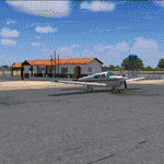
This is the Lencois Maranhenses National Park and Barreirinhas City at northeast Brazil (2th Verion): a great visual flight experience. Including detailed terminal and runway, the Preguicas river, The Mandacaru Lighthouse and the early works of a new airfield.
| Filename: | Barreirinhas_2nd_Version.zip |
| License: | Freeware, limited distribution |
| Added: | 17th November 2010, 03:15:08 |
| Downloads: | 1,359 |
| Author: | Jorge Amengol |
| Size: | 32.11 MB |
| Category: Flight Simulator 2004 - Scenery | |
| Tongass Remote Airfield v2 - for Tongass Fjords |
|
Images related to this file:
File Description:
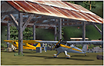
Tongass Remote Airfield v2 - for Tongass Fjords (FS9)
"Tongass Remote Airfield" v2 (RATR) Alaskan bush flying scenery (Fictitious).
This airstrip is for Flight Simulator 2004 and for the "Tongass Fjords" (FS9) addon by Holger Sandmann & Bill Womack; you must have "Tongass Fjords" (FS9) for this to work. Version 2 is a detailed, stand alone, remake of the first version, see PDF file.
Field history and description:
In the early days this area was well known to prospectors and hunters. A small mine was established and later abandoned. Around the late 40s a crew was contracted to clear a small landing area to gain easier access for hunters and campers. Due to the extreme remoteness of this area that clearing took several years. The last phase was the approach, clearing by hand a descending glide slope through just the tops of the tall trees. There is now just enough room for a very experienced pilot to get in and out of this field. The airfield is 26 miles north of Petersburg Alaska (PAPG). This is a tricky narrow approach with a left hand dogleg and then an immediate right hand dogleg turn just before the final approach. Not much time to set up your approach; also, it's a very short runway. For experienced pilots only, and make sure that your life insurance is up to date. Good luck.
| Filename: | Tongass_Remote_Airfield_v2__for_Tongass_Fjords.zip |
| License: | Freeware, limited distribution |
| Added: | 22nd March 2010, 13:16:16 |
| Downloads: | 625 |
| Author: | Jay Langham |
| Size: | 6.18 MB |
| Category: Flight Simulator 2004 - Scenery | |
| Graskop Airfield, South Africa |
|
Images related to this file:
File Description:
Graskop Airfield does not appear in the default FS2004, neither is the town included which is a pity as the airfield lies right on the edge of a gorge where bungee jumping and even a Gorge-lift (elevator) or a slide across the gorge can be enjoyed by the adrenaline junkies. Added to this, the airfield (and town of Graskop) is merely 10km from the world famous God's Window (also featured in the film, "The Gods must be Crazy").
This package will add a custom (Gmax & Sketchup) made Graskop Airfield, Mpumalanga, South Africa with photoreal textures and ground textures. The included Landclass file will also add the town.
The small airfield has been recreated with custom true to life models and photoreal textures. While being a very small airfield with only one hangar and a large antenna tower, the importance of the airfield far outweighs its size. The airfield plays a vital role in the fight against wildfires as there are water bombers based at the airfield during critical times. In real life the runway is quite challenging, being sloped quite significantly and very narrow, with a one-way-in one-way-out landing and takeoff procedure. Due to the limits within flightsim, the slope could not be replicated but all the other challenges are there.
The asphalt runway is aligned 15/33 and only 800m long by 8.5m wide and sits at an elevation of 4 854ft.
| Filename: | Graskop_Airfield_South_Africa.zip |
| License: | Freeware, limited distribution |
| Added: | 3rd September 2021, 00:55:30 |
| Downloads: | 158 |
| Author: | Kobus van Wyk & Morne van Wyk |
| Size: | 4.13 MB |
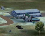
| Category: Flight Simulator 2004 - Scenery | |
| Smithers CYYD in British Columbia, Canada, Updated |
|
Images related to this file:
File Description:
Made in December 2018 as an update of the original post of 2014, to correct the apron markings, revise the AI, increase the number of GA parking spots, and most importantly to correct the runway lighting by adding the missing approach lights. This scenery is complete and can be installed as-is without first installing the 2014 version. Smithers is in northwest BC, 60 miles east and a bit north of Terrace, and directly east of the southern border of Alaska. The town has a population of 5,500 and is set in a north-south valley between mountains, the most impressive of which is Hudson Bay Mountain to the west. The airport is to the north of the town and has a single runway of 7,544 feet, aligned 33-15. The main user is Central Mountain Air, who are headquartered in Smithers and have a large maintenance hangar there next to the terminal building. The airport has scheduled flights by Central Mountain Air, Jazz, and Hawk Air, which are in the AI. The AI provided here is a new CYYD traffic bgl; in total the AI also includes a Dawson Creek traffic bgl (recently revised and posted) plus a Terrace traffic bgl (which will shortly be revised and posted). An Electra of Conair (who are the largest operator of fire fighting planes in BC, and have re-fill tanks in Smithers) is included and also a HS 748 of Air North.
| Filename: | Smithers_CYYD_in_British_Columbia_Canada_Updated.zip |
| License: | Freeware, limited distribution |
| Added: | 4th January 2019, 18:08:03 |
| Downloads: | 214 |
| Author: | Roger Wensley |
| Size: | 14.22 MB |
| Category: Flight Simulator 2004 - Scenery | |
| EDBA - Arnstadt-Alkersleben Airfield |
|
Images related to this file:
File Description:
Arnstadt-Alkersleben is a small airfield just south of Erfurt Airport (Thuringia).
| Filename: | EDBA__ArnstadtAlkersleben_Airfield.zip |
| License: | Freeware |
| Added: | 11th June 2012, 07:53:30 |
| Downloads: | 755 |
| Author: | Volker Loew, Rolf-Uwe Hochmuth |
| Size: | 1.34 MB |
| Category: Flight Simulator 2004 - Scenery | |
| Bitterwasser Thermals |
|
File Description:
This scenery package covers a huge area around Bitterwasser (Namibia) with Thermals.
| Filename: | Bitterwasser_Thermals.zip |
| License: | Freeware |
| Added: | 29th February 2004, 23:40:25 |
| Downloads: | 634 |
| Author: | Herbert and Julian Zemke |
| Size: | 728.6 KB |
| Category: Flight Simulator 2004 - Scenery | |
| Venezuela Thermals |
|
File Description:
A set of thermals that include most of the Territory of Venezuela
| Filename: | Venezuela_Thermals.zip |
| License: | Freeware |
| Added: | 30th August 2005, 13:19:01 |
| Downloads: | 613 |
| Author: | Alejandro Villa |
| Size: | 2.3 MB |
| Category: Flight Simulator 2004 - Scenery | |
| Starry Eyes Intl |
|
File Description:
Starry Eyes Intl-a nice liitle airport to fly in out of
| Filename: | Starry_Eyes_Intl.zip |
| License: | Freeware |
| Added: | 17th October 2005, 04:45:40 |
| Downloads: | 211 |
| Author: | Babya Software Group |
| Size: | 94.61 KB |
| Category: Flight Simulator 2004 - Scenery | |
| KBIS Bismarck North Dakota |
|
Images related to this file:
File Description:
Here is a redesign of Bismarck North Dakota, as of summer 2010.
| Filename: | KBIS_Bismarck_North_Dakota.zip |
| License: | Freeware |
| Added: | 4th November 2010, 02:30:16 |
| Downloads: | 1,206 |
| Author: | Eric Cagan |
| Size: | 13.08 MB |
| Category: Flight Simulator 2004 - Scenery | |
| LFMU Beziers-Vias, France |
|
Images related to this file:
File Description:
LFMU "Beziers-Vias" is a French regional airport Near the Mediterranean Sea.
| Filename: | LFMU_BeziersVias_France.zip |
| License: | Freeware |
| Added: | 8th September 2010, 09:46:50 |
| Downloads: | 1,176 |
| Author: | Guy Lejolivet |
| Size: | 11.27 MB |
© 2001-2026 AVSIM Online
All Rights Reserved
Privacy Policy |