
Where Flight Simulation Enthusiasts Gather from Around the World!
AVSIM Library - Search Results

| Category: Flight Simulator 2004 - Scenery | |
| Zion National Park South, Hurricane (1L8), Colorado City (KAZC), Utah/Arizona, Photo-Scenery (FS9 & FSX) |

|
Images related to this file:
File Description:
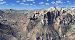
Covers the southern part of Zion National Park extends south along the cities of Hurricane and Colorado City. Zion National Park is another place where erosion of the Colorado Plateau formed the most beautiful colorful stone formations of unique and wonderful shapes. There are nine different layers of stone visible in the park. Most of them consist of sandstone. But there is also limestone, gypsum, siltstone, shale, clay and mudstone. The Virgin River cut a spectacular and famous canyon thru Zion Park that is as narrow as 20ft and up to 2000ft tall.
High resolution versions of this scenery for FS9 and FSX (much sharper, but larger and multiple downloads)
are available at www.blueskyscenery.com/CNY_South3West5.html . The screenies are taken from the high-res versions,
so expect this version to be slightly more blurry. Thanks to Joop Mak for providing custom AFCADs that
correct airport layouts so that they align with the photo-textures! They are available at www.blueskyscenery.com/AFCADs.html . YourDonation@Work: Dedicated to Jerry, Ralph J. and Lance.
| Filename: | Zion_National_Park_South_Hurricane_1L8_Colorado_Ci.zip |
| License: | Freeware, limited distribution |
| Added: | 20th March 2010, 23:26:42 |
| Downloads: | 1,784 |
| Author: | Gottfried Razek - blueskyscenery.com |
| Size: | 95.39 MB |
| Category: Flight Simulator 2004 - Scenery | |
| Alaska South Slope 4; Selawik PASK |
|
Images related to this file:
File Description:
There are four main northwestern Alaska towns which are serviced by Alaska Airlines, and from which local flights spread out. The northernmost is Barrow. Southwest of Barrow is Kotzebue, then Nome, and the furthest south is Bethel. This series is for the flights from and around Kotzebue, mostly on the South Slope of the Brooks Range of mountains. There will be further additions. Selawik is a village (population now around 760) around 75 miles east of Kotzebue on three of the delta islands of the Selawik River where it flows into Selawik Lake. The delta forms part of the Selawik National Wildlife Refuge for migratory birds. The airfield is just next to the village, with two runways, 3,450 feet of lit gravel aligned 03-21 and 3,100 feet of gravel aligned 09-27. There are scheduled flights by Era (now renamed Ravn) and by Bering Air, both of them originating in Kotzebue and routing east to Noorvik, Kiana, Selawik, etc, and then back again. The AI includes these flights along with Everts Air and GA.
| Filename: | Alaska_South_Slope_4_Selawik_PASK.zip |
| License: | Freeware, limited distribution |
| Added: | 9th October 2016, 04:17:52 |
| Downloads: | 213 |
| Author: | Roger Wensley |
| Size: | 4.34 MB |
| Category: Flight Simulator 2004 - Scenery | |
| HSSS Khartoum, Sudan |
|
File Description:
Googly scenery for HSSS Khartoum, Sudan. For Sudan's main international airport,
the Flight Simulator depiction is somewhat simplified, depicting just a few
buildings which are badly located. These scenery files attempt to reproduce
the real atmosphere of the airport - from the huge clutter of small hangars
and workshops and large quantities of inactive planes through to the aircraft
dump at the north end of the airport.
The scenery does not purport to be ultra-accurate. Based on high-detail satellite
imagery from Google Earth, the layout is proportionally correct but the added
airport features, such as buildings, are built from default Microsoft objects
and third-party object libraries so will not look like the real thing.
You are not obliged to download and install any additional scenery libraries,
but to enjoy this scenery in its entirety, you may wish to. It will work fine,
with or without. These files complement the Sudan Airways AI Fleet Pack by Billy Rutherford &
John Hinson, updating the scenery files contained therein, but the two are not
inter-dependent.
| Filename: | HSSS_Khartoum_Sudan.zip |
| License: | Freeware |
| Added: | 9th March 2007, 17:29:13 |
| Downloads: | 4,417 |
| Author: | John Hinson |
| Size: | 38.74 KB |
| Category: Flight Simulator 2004 - Scenery | |
| Colombian Airports - Update |
|
File Description:
This is an update to my previous Colombian Airports upload colapts1.zip.
The update contains mainly some navaid corrections to SKFL, SKIB, and SKVP, and adds the airport SKSJ Jorge E. Gonzales of San Jose del Guaviare; this is now at the correct location and altitude and has buildings, objects, and landclass added. It is for FS9 default scenery and the Colombia freeware mesh by Raimondo Taburet. However, the scenery should also work with the default or any other mesh but I have not tested it.
However, please NOTE:
that in the default scenery without mesh the airport SKSJ will be below the rest of the surface whereas with the mesh, the airport will be at the same altitude as the rest of the scenery with the exception of the river which now runs at a higher (the default) altitude (see screenshots). For me flying without the mesh does not make any sense, so I live with that restriction. If you don't like it, you can always delete or deactivate the files starting with "SKSJ".
| Filename: | Colombian_Airports__Update.zip |
| License: | Freeware |
| Added: | 10th September 2014, 14:50:05 |
| Downloads: | 1,437 |
| Author: | Detlev J. Rohmer |
| Size: | 5.4 MB |
| Category: Flight Simulator 2004 - Scenery | |
| CYQR Regina (Regina International Airport and Roland Groome Field) Version 2 |
|
Images related to this file:
File Description:

Regina International Airport can trace its history back to 1919, when Regina airport became the first registered air harbour in Canada. This virtual model of CYQR represents the airport as it was in spring of 2007. CYQR airport is the gateway to southern Saskatchewan, Canada and is situationed in Regina, which is the provincial capital. The airport is served by Air Canada, Air Canada JAZZ, Westjet, West Wind, Express Air, Northwest Airlines and United Airlines. The airport is named for Roland Groome, who was the first registered pilot in Canada.
This scenery is a re-upload of version 2 of the scenery, which was lost in the AVSIM hack. Nothing has changed.
This scenery was constructed using GMAX and includes nearly every airport and commercial building on the airport property. Beyond the airport itself this scenery also includes, as an option, the major landmark buildings in the city of Regina proper and those on the runway approaches. Regina City buildings are meant to enhance the realism of virtual flying in the Regina area.
| Filename: | CYQR_Regina_Regina_International_Airport_and_Rolan.zip |
| License: | Freeware |
| Added: | 7th May 2010, 12:49:25 |
| Downloads: | 6,907 |
| Author: | Gregory Putz |
| Size: | 10.99 MB |
| Category: Flight Simulator 2004 - Scenery | |
| Northern Oman SRTM mesh |
|
File Description:
This terrain mesh scenery covers northern of Oman emirate as well as some parts of United Arab Emirates (Dubai, Sharjah, Ras Al Khaima, Fujiarah...). The southern and western boundaries are approx 22°N / 54°E.
No part of Iran has been included.
Based on SRTM Data (3 arcsec, 90m) and sampled to LOD9 resolution (76m) using Matthew Styles's program "SRTM To BGL v1.04". While only tested with Fs2004, this mesh should also run with FS2002.
SRTM 3 arcsec dataset has numerous void areas in this part of the world. But thanks to John Child's beautiful and powerful "Blackart" utility it's now easy to patch these areas with lower resolution dataset: I took the coupled interpolation method to merge SRTM 3-arcsec with SRTM 30-arcsec dataset when needed. This gives the best results, as patched areas with 30-arcsec data are blending naturally with surrounding 3-arcsec mesh. Of course the resolution of patched areas is quite poor, but still a bit better than the default LOD5 mesh.
| Filename: | Northern_Oman_SRTM_mesh.zip |
| License: | Freeware, limited distribution |
| Added: | 20th June 2004, 14:11:59 |
| Downloads: | 8,221 |
| Author: | Yohann Baptiste |
| Size: | 16.44 MB |
| Category: Flight Simulator 2004 - Scenery | |
| Santorini LGSR Big Scenery 2012 (airport and full island scenery) |
|
Images related to this file:
File Description:

This FS2004 project is about the greek Santorini island (located in the Aegean Sea 200 km southeast from Greece's mainland) and contain two main scenery parts:
1) the "Santorini (Thira) International Airport" (Iata: JTR, Icao: LGSR) where you'll find all buldings (airport and close sourroundings buildings), hundred of custom made detailed objects, static and animated vehicles, animated scenery parts and various effects.
2)the Santorini island scenery where you'll find real hand-made landmarks (churches, factories, windmills,harbors and more), boats/ferries, completely redesigned landclasses with custom (seasonal+night) ground textures, coastlines, roads, main towns with custom greek textures, extreme autogen density and a lot of objects.
Every scenery part (frame-rate friendly thanks to the low poly design) has photoreal textures and everything is placed in the right position (wich was found at spring 2012) and in according to the satellite image.English extendet handbook is included. Watch the screenshot and the demo video on the Albysim youtube chanel and enjoy all scenery features (in this free/demo edition some features are limited).
| Filename: | Santorini_LGSR_Big_Scenery_2012_airport_and_full_i.zip |
| License: | Check within download |
| Added: | 4th November 2012, 13:13:55 |
| Downloads: | 4,711 |
| Author: | Albysim Scenery Design (Alberto Di Bolzano) |
| Size: | 35.43 MB |
| Category: Flight Simulator 2004 - Scenery | |
| Colorado Lakes Project II |
|
File Description:
This project features the Blue Mesa Reservoir and the Black Canyon of the Gunnison and adds over 300 highly detailed lakes to the central portion of western Colorado. Three reservoirs, named for corresponding dams on the Gunnison River, form the heart of Curecanti National Recreation Area. Panoramic mesas, fjord-like reservoirs, and deep, steep and narrow canyons abound. Blue Mesa Reservoir is Colorado's largest body of water, and is the largest Kokanee Salmon fishery in the United States. Morrow Point Reservoir is the beginning of the Black Canyon of the Gunnison and below it is Crystal Reservoir.
These lakes are specifically designed to show off their photo realistic detail when used in combination with "FSGenesis-The Rockies 38.2m Terrain Mesh-Colorado" available as "fsg_dem38m_usrk_co.zip" at avsim.com, or comparable mesh. The free FSGenesis US National Landclass Project Beta 6 also adds beautifully to the landscape. These lakes work equally as well with the default mesh.
All lake information was projected from satellite imagery and compiled with a beta version of Jim Keir's "Slartibartfast" utility. Much thanks to Holger Sandmann and Jim Keir for their help and advice on interpreting the satellite data properly.
| Filename: | Colorado_Lakes_Project_II.zip |
| License: | Freeware |
| Added: | 1st June 2004, 02:34:42 |
| Downloads: | 6,050 |
| Author: | Carlyle Sharpe |
| Size: | 332.25 KB |
| Category: Flight Simulator 2004 - Scenery | |
| Legnano scenery - Italy |
|
Images related to this file:
File Description:
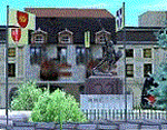
Homage to my town, scenery built mainly with existing objects, buildings by sintax and few experiments by GMax. It DOES NOT include any airport, but represents some pictures of Legnano town
Informations: Legnano is a town in north of Italy (approx 25 kmt NW Milan, ref coordinates N45 35.98 E8 54.59), reachable from Casorezzo ultralight airport (closest one) or all the near others of Milan area.
Here was done in 1176 the historical fight of the Alliance Lombarda's city-states against Federico Barbarossa German imperator. Legnano is also well known for his metallurgical and textile industries story.
Contents: rev.1 : down town square with municipal Palazzo Malinverni and S. Magno basilica, skyscraper, one of Olona river's bridges, G. Mari football stadium, Alberto da Giussano circus with related monument, encircled by the eight quarter's flags, F. Tosi and Manifattura industrial buildings, Rail station, external parking and glass building
rev.2 : Courthouse building with Teresa's face bronze statue and some more buidings, Palio hystorical figurants inside the stadium, Carroccio and Alberto da Giussano rider, Small goods train on railroad; S. Magno belltower reviewed, red sky-lights on top of skyscraper and chimney, Chimney smoke
| Filename: | Legnano_scenery__Italy.zip |
| License: | Freeware |
| Added: | 27th March 2011, 02:55:40 |
| Downloads: | 648 |
| Author: | Aldo Della Vedova |
| Size: | 6.83 MB |
| Category: Flight Simulator 2004 - Scenery | |
| International Pan American Airport - Dinner Key, Coconut Grove (Miami), Florida |
|
File Description:
"From 1933-1945, Dinner Key in Coconut Grove (Miami), Florida was Pan American Airways Latin
American Hub for its Flying Boat fleet. Dinner Key was so named because many families used to
come out and have picnic dinners and watch the Sikorsky’s, Martin’s, and Boeing’s leave for
exotic ports. In 1950, the terminal became Miami’s City Hall with the surrounding area
becoming a marina."
For Default scenery.. not tested in others. Uses both RWY12(latest version with all add on
libraries included) AND Lago FSE (Payware)
Two methods of installing.. which ever works best for you. One - simply drop the Dinner Key
folder into your add-on scenery section of flightsim and install according to SOP... start it
up..add and activate it close program and start again or TWO - remove the three .bgl files
from the scenery file ... the afcad, the exclude, and the rwy12 .bgl and place them in your
add-on scenery\scenery file ... then start flightsim.. it will automaticly configure it.
the .se2 file goes into LAGO\FSE\Data file (you will need lago for this to work.
comments or questions [email protected]
| Filename: | International_Pan_American_Airport__Dinner_Key_Coc.zip |
| License: | Freeware |
| Added: | 30th August 2005, 21:22:33 |
| Downloads: | 1,473 |
| Author: | Dale Caruso |
| Size: | 332.34 KB |
© 2001-2026 AVSIM Online
All Rights Reserved
Privacy Policy |