
Where Flight Simulation Enthusiasts Gather from Around the World!
AVSIM Library - Search Results

| Category: Flight Simulator 2004 - Scenery | |
| Burlington-Alamance Regional KBUY |

|
File Description:
This scenery is unique in that it is designed for the student or visiting pilot flying in
and out of this airport. All navaids are as accurate as possible for FS9. Glideslope is scheduled to be activated in October 2003.
(The new 6,000' extension has been delayed and completion date is now 2004). Both are
included. Numerous navaids and aerial photographs were used. Approved for practice but not for
navigation. Check current NOTAMS.
Special thanks to Dan the Airport Manager and Mark the Chief Flight
Instructor. See Dan or Mark for CD copies of this file.
If you are planning on coming to the Piedmont or are a student pilot you will want this! Special readme inside.
-jimmy R martin &
David Fraizer
[email protected].
| Filename: | BurlingtonAlamance_Regional__KBUY.zip |
| License: | Freeware |
| Added: | 4th September 2003, 18:20:47 |
| Downloads: | 1,963 |
| Author: | jimmy R martin & David Fraizer |
| Size: | 3.47 MB |
| Category: Flight Simulator 2004 - Scenery | |
| Portland KPDX Scenery Enhancement |
|
File Description:
Re-upload. The default FS9 KPDX scenery is not bad, but it's out of date and lacks jetways. I didn't set out to recreate KPDX in detail, just to make the terminal building more accurate. This enhancement has the following features:
1. A new terminal building and parking structure are now accurately sized and placed.
2. The control tower was moved to its correct position.
3. The correct number of jetways has been added.
4. Ramp lighting has been added.
5. Some inaccuracies in the aprons and taxiways have been fixed.
6. The misaligned ILS for runway 28L has been corrected.
7. The afcad has been redone. If you are using Ultimate Traffic you should see more accurate AI traffic parking.
| Filename: | Portland_KPDX_Scenery_Enhancement.zip |
| License: | Freeware |
| Added: | 21st June 2010, 11:09:47 |
| Downloads: | 4,324 |
| Author: | Sidney Schwartz |
| Size: | 1.19 MB |
| Category: Flight Simulator 2004 - Scenery | |
| Southern California Oilrigs v2.0 |
|
File Description:
This is a revised version of my previous rendition of the Oil Rigs off the Southern California Coastline. This file acurately represents the positions of ALL of the Oilrigs extending from Lompoc to Newport Beach, California. Also included are 4 lighthouses not placed in the FS2004 Default Scenery located from Morro Bay - Point Conception, California. * * REQUIRES RWY 12 * * This add-on was created with Runway 12 add-on, so you must have this add-on installed, or at least the scenery BGL and Texture files installed in your Addon Scenery\Static Objects Library folder for the scenery to work. In addition, the scenery was created while using Ultimate Terrain USA, so default FS2004 Scenery users may have some scenery items in slightly different places.
| Filename: | Southern_California_Oilrigs_v20.zip |
| License: | Freeware |
| Added: | 24th September 2005, 18:43:11 |
| Downloads: | 1,326 |
| Author: | Brian C. Selb |
| Size: | 63.56 KB |
| Category: Flight Simulator 2004 - Scenery | |
| Bardenas Reales Firing Range Version 1.0 |
|
File Description:
Photorealistic scenery of the Firing Range of Bardenas Reales, in Navarra, Spain, close to LEZG ( N42º10.6',W1º28.0'). Created on 1951, this range was the practice area for air to surface weapons for the spanish air force pilots of EF18M, F1M, F5M and AV8 harriers. Usually is used for other allied forces like USAF F16. Actually the use of the firing range is decreasing @ 20% of the full capacity of 100 operations by day. Only textures 4.75 m/pixel, we recomend mesh EVA4,(http://www.airhispania.com/eva/eva.htm) or similar containing detailed topo of spain. Created By Jose Ramon Rodriguez ( this a present to all my friends of Virtual ZAragoza Airbase - www.basezaragozavirtual.tk -, specially to Diego Novillo by his support and illusion in this, and other projects, thx.
| Filename: | Bardenas_Reales_Firing_Range_Version_10.zip |
| License: | Freeware |
| Added: | 18th July 2006, 19:31:31 |
| Downloads: | 3,873 |
| Author: | Jose Ramon Rodriguez |
| Size: | 13.71 MB |
| Category: Flight Simulator 2004 - Scenery | |
| Red Lake (CYRL) and (CKS4) V2 Fix in Ontario, Canada |
|
Images related to this file:
File Description:
This V2 Fix adds missing textures for the town buildings around the float base CKS4; thanks to Guido, Harry, and Jens for pointing out the mising items. Unzip the textures into the CYRL texture folder, and say yes to over-write as these are ALL the building textures (I hope); this was easier than checking individual missing files. In the notes there is a further complaint from me regarding downloaders who SEE that textures are missing and then do not email me; it is easy for you to see while I cannot visually check; all my textures have to be in the main texture folder and are therefore never missing. I have to go through lists of objects and then lists of their textures.
| Filename: | Red_Lake_CYRL_and_CKS4_V2_Fix_in_Ontario_Canada.zip |
| License: | Freeware, limited distribution |
| Added: | 23rd November 2015, 14:38:56 |
| Downloads: | 271 |
| Author: | Roger Wensley |
| Size: | 22.68 MB |
| Category: Flight Simulator 2004 - Scenery | |
| GERMANY 2004 SRTM MESH SCENERY |
|
File Description:
Based on SRTM 3 arc.sec data.
Unfortunately SRTM DATA have many holes and data loss, so I made a resampling and an oversampling with other data with lower resolution, but with better coverege (like data from swiss topographic federal istitute or from italian IGM, and finally with DTED Level 0.) with geo cad software like Grass and GlobalMapper for projection convertion.
Compression and conversion to bgl with MS Flight simulator SDK at LOD 9
This scenery cover the entire Germany teritory, the part of Swiss and Austria territories not included in my Italian scenery. Parts of Belgium and Netherlands and Luxembourg are included too (Till E005); next quite the whole territory of Czech Republic and part of Poland till E017.
| Filename: | GERMANY_2004_SRTM_MESH_SCENERY.zip |
| License: | Freeware |
| Added: | 23rd November 2003, 23:18:46 |
| Downloads: | 25,895 |
| Author: | Pietro Mauri |
| Size: | 62.08 MB |
| Category: Flight Simulator 2004 - Scenery | |
| Rangiroa 2004 |
|
File Description:
FS2004 Scenery TAHITI RANGIROA SCENERY Ver.3.0
These files improve specific scenerys (Rangiroa
Islands, Tahiti, French Polynesia) of FS2004.
Rangiroa located About 200 miles northeast of
Tahiti Island. Rangiroa is the largest atoll in
the Tuamotu Archipelago. The lagoon is very very
beautiful!!! I tried my best to make the model of
this beautiful Islands. Especially I invented
penetration processing of the beautiful
coastline of Rangiroa. This scenery including
Kia-Ora Village, Avatoru and Tiputa.
Included atolls: Rangiroa, Tikehau, Mataiva, Manihi and Ahe.
This scenery has a quite long visibility
(approximately 100Km) with using LVR( Long Visual
Range Tool ). You can look around the whole
Rangiroa atoll. Furthermore you can see Tikehau
islands from Rangiroa, and Mataiva islands from
Tikehau.
| Filename: | Rangiroa_2004.zip |
| License: | Freeware, limited distribution |
| Added: | 18th May 2004, 22:42:50 |
| Downloads: | 9,186 |
| Author: | Kazuo Kawamura |
| Size: | 20.58 MB |
| Category: Flight Simulator 2004 - Scenery | |
| Colorado Springs North, Colorado, Photo-Scenery (FS9 & FSX) |
|
Images related to this file:
File Description:
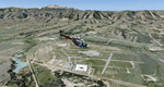
This region covers the area between Denver and Colorado Springs. It extends my Denver scenery to the south.
Just north of Colorado Springs you can see the widespread United States Air Force Academy which, with it's
many buildings, covers a huge area of 18.000 acres. The Academy Airfield (KAFF) which lays in the northeastern
corner of the area is used for training cadets in airmanship courses, including parachute training,
soaring and powered flight.
High resolution versions of this scenery for FS9 and FSX (much sharper, but larger and multiple downloads)
are available at www.blueskyscenery.com/GNB_South2East.html . The screenies are taken from the high-res versions,
so expect this version to be slightly more blurry. YourDonation@Work: Dedicated to Robin and Raymond.
| Filename: | Colorado_Springs_North_Colorado_PhotoScenery_FS9__.zip |
| License: | Freeware, limited distribution |
| Added: | 3rd February 2010, 02:09:59 |
| Downloads: | 2,187 |
| Author: | Gottfried Razek - blueskyscenery.com |
| Size: | 96.91 MB |
| Category: Flight Simulator 2004 - Scenery | |
| Gustavo Rojas Pinilla International Airport (SKPS) 2011 |
|
File Description:
Gustavo Rojas Pinilla International Airport (IATA: ADZ, ICAO: SKSP) is the leading airport in the archipelago of San Andres, Providencia and Santa Catalina, which has enough capacity to receive large aircraft, due to a number of
charter flights and seasonal in different parts of America and Europe.
This file has the right coordinates, with the apron and characteristics of the airport. The runways were reoriented to the correct direction, runway were re-sized the gates placed on correct location and number, FAC was placed
(Colombian Air force and Colombian National Army) all the airport charts required to navigate in and out of this airport can be found at www.aerocivil.gov.co/ under Informacion Aeronautica click AIP; on AIP
click Aerodromos then click at SKSP.
| Filename: | Gustavo_Rojas_Pinilla_International_Airport_SKPS_2.zip |
| License: | Freeware |
| Added: | 23rd August 2011, 02:27:32 |
| Downloads: | 1,361 |
| Author: | Anwar Gonzalez |
| Size: | 6.29 KB |
| Category: Flight Simulator 2004 - Scenery | |
| Airfield Delta Club Napoli |
|
File Description:
Scenery of airfield Delta Club Napoli situated 20 NM nord of Naples:
41° 3 55 Nord ; 13° 57 45 Est; ICAO Code: CECV
Features:
-Contain RW 06/24 two Hangars, one for parking and one for maintenance certified Tecnam;
-Gas station;
-Structure for the control of an unmanned airplane TECNAM forecast for collections by the Campania region
****************************
Aviosuperfice Delta Club Napoli situata a 20 nm da Napoli
41° 3 55 Nord; 13° 57 45 Est; Codice ICAO: CECV
Caratteristiche:
-Contiene RW 06/24, due hangar, uno per il parcheggio e una per la manutenzione certificata TECNAM; -Distributore di benzina; -Struttura per il controllo di un Tecnam senza pilota per le previsioni meteo da parte della Regione Campania
| Filename: | Airfield_Delta_Club_Napoli.zip |
| License: | Freeware |
| Added: | 15th January 2010, 20:19:57 |
| Downloads: | 608 |
| Author: | Stanislao Senese |
| Size: | 1.77 KB |
© 2001-2026 AVSIM Online
All Rights Reserved
Privacy Policy |