
Where Flight Simulation Enthusiasts Gather from Around the World!
AVSIM Library - Search Results

| Category: Flight Simulator 2004 - Scenery | |
| Pacific Northwest Airports 1960 |

|
File Description:
We've produced this scenery to provide new GMAX terminals, taxiways, buildings and details as they were around 1960 for Seattle, Washington and Portland and Salem, Oregon. I've also created 34 smaller classic airports in Idaho, Oregon, and Washington then served by airlines. These do not include custom GMAX terminals but use instead a default or addon library object for the terminal, since I did not have photos. Many thanks to Jason, who provided most of the photos and information used in this project, as well as the Jantzen Beach amusement park on an island in the river and most of KPDX except the terminal. Tom created the rest.
| Filename: | Pacific_Northwest_Airports_1960.zip |
| License: | Freeware, limited distribution |
| Added: | 6th May 2008, 03:52:32 |
| Downloads: | 4,515 |
| Author: | Tom Gibson and Jason Krogmann |
| Size: | 10.21 MB |
| Category: Flight Simulator 2004 - Scenery | |
| CJN4 Assiniboia Saskatchewan, Canada |
|
Images related to this file:
File Description:

Assiniboia Airport is located 11 km (7 miles) north of the town of Assiniboia in south central Saskatchewan, Canada. The airport is situated on the site of the wartime aerodrome built as part of the British Commonwealth Air Training Plan.
CJN4 Assiniboia was constructed using GMAX. It includes photo-real custom models of all the buildings at the airport, runway signs, refueling facilities, weather station, vehicles, runway and taxiway lighting and a rotating beacon. It also includes custom ground textures to replicate the crumbling decommissioned runways and cracked tarmac. The scenery replicates the pilot activated ARCAL lighting of airfield approach lights, edge lights, runway and taxiway lights.
| Filename: | CJN4_Assiniboia_Saskatchewan_Canada.zip |
| License: | Freeware |
| Added: | 4th September 2010, 19:13:59 |
| Downloads: | 1,052 |
| Author: | Gregory Putz |
| Size: | 9.11 MB |
| Category: Flight Simulator 2004 - Scenery | |
| Europe SRTM mesh Part 13: Western Spain & Portugal |
|
File Description:
Europe SRTM LOD9 mesh part 13 of 13: Covers Spain west of 4.5°W and Portugal.
This Europe SRTM project was optimized for the lowest HDD space use: Each part macthing exactly the boundaries of its neighbors, you'll have a complete corevage of Europe without gap or overlapping scenery. Based on SRTM Data v1 and v2 (3 arcsec, 90m) and sampled to LOD9 resolution (76m). Each SRTM tile was carefully checked and repaired with Blackart v4.02: water areas are now flattened (lighter mesh), and SRTM voids were treated taking advantage of Blackart's sophisticated interpolation algorithm. When required, biggest voids were patched with oversampled SRTM 30 arcsec data and/or manual input.
| Filename: | Europe_SRTM_mesh_Part_13_Western_Spain__Portugal.zip |
| License: | Freeware, limited distribution |
| Added: | 20th October 2005, 11:22:13 |
| Downloads: | 15,506 |
| Author: | Yohann Baptiste |
| Size: | 34.22 MB |
| Category: Flight Simulator 2004 - Scenery | |
| KLAX - Los Angeles World Airport |
|
Images related to this file:
File Description:
This is a total remake of the default KLAX airport. All of the terminals, cargo areas and maintenance buildings have been completely redone using google maps and Airport Design Editor. There is the new Tom Bradley Intl Terminal along the planned second Intl terminal, the elevated shuttle, and the West End RON/Maint area. The Union 76 DC-s is also on display at the Flight Path Museum on the south side of the airport. I also included the historical Spanish Mission style Hangar One located next to the FedEx parking ramp. Each terminal has been remade to conform to placement and size using google maps. Enjoy the scenery.
| Filename: | KLAX__Los_Angeles_World_Airport.zip |
| License: | Freeware |
| Added: | 17th April 2015, 21:10:46 |
| Downloads: | 4,699 |
| Author: | Johnny Alford |
| Size: | 34.8 MB |
| Category: Flight Simulator 2004 - Scenery | |
| Real Landclass of Dublin Airport and surrounding area incl. the town of Swords |
|
File Description:
In FS2004 the default Landclass of Dublin Airport and it's surrounding area is not the same as in reality.
In FS2004 the Airport is surrounded by residential areas in the south, southwest and southeast and with dry grass land in the north, northwest and northeast. Also the town of Swords (in the north of Dublin Airport) is not included as well as
some golfing areas.
With this file you will get a more realistic landclass of Dublin Aiport and it's surrounding area. As in reality the airport is surrounded by farmingfields and corplands as well as some golfing areas and most important the town of Swords in the north.
| Filename: | Real_Landclass_of_Dublin_Airport_and_surrounding_a.zip |
| License: | Freeware |
| Added: | 2nd July 2008, 15:30:41 |
| Downloads: | 2,851 |
| Author: | Dave Sheffield |
| Size: | 13.94 KB |
| Category: Flight Simulator 2004 - Scenery | |
| Barbados International Airport |
|
Images related to this file:
File Description:
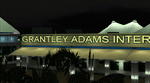
Grantley Adams International Airport for FS2004 (Re-uploaded + 1.1 update included)
This scenery represents a complete redevelopment of the stock FS2004 airport and reflects the state of the airport in 2007/2008. Features 3D models of the main terminals made in GMAX plus cargo area, fire station, Concorde Experience Museum and other ancillary structures in the airport property and beyond, photoreal ground polygons designed in GMax, 3D taxi lighting and approach lighting system for Runway 09, small Landclass update for Bridgetown and surrounding districts to bring in line with real life geography. ** FS2004 ONLY ** See FSX Library for the FSX version. Enjoy your visit to sunny Barbados!
| Filename: | Barbados_International_Airport.zip |
| License: | Freeware, limited distribution |
| Added: | 13th December 2009, 03:31:53 |
| Downloads: | 16,926 |
| Author: | Max Kraus |
| Size: | 66.73 MB |
| Category: Flight Simulator 2004 - Scenery | |
| RJST - Matsushima Air Base - Miyagi Japan |
|
Images related to this file:
File Description:
This project represents Matsushima Air Base (RJST) in Miyagi Japan, home of the the F-2 training for the JASDF and the Blue Impulse aerobatic team. Matsushima was heavily damaged by the tsunami following the 2011 Tohoku earthquake and is in the process of extensive rebuilding and remodeling.
Included are scenery for Matsushima and paints and flight plans for the F-2B aircraft of 21 Squadron. The full squadron is represented even though only a few of them have been fully repaired and returned to service since the tsunami.
To use the AI aircraft, you will need the HTAI F-16D drag chute models.
| Filename: | RJST__Matsushima_Air_Base__Miyagi_Japan.zip |
| License: | Freeware |
| Added: | 27th October 2015, 12:18:16 |
| Downloads: | 787 |
| Author: | Brent Newman |
| Size: | 4.71 MB |
| Category: Flight Simulator 2004 - Scenery | |
| Bella Coola CYBD in British Columbia, Canada |
|
Images related to this file:
File Description:
Bella Coola is in one of the deep east-west fjords amid the Coastal Range on the coast of BC, approximately mid way between Vancouver and the Alaskan border and some 70 miles inland from the open ocean. The town of Bella Coola has a small population of around 150, while the population of the whole Bella Coola Valley is around 2,000. The valley is warmer in both summer and winter than the surrounding area, and tourism flourishes along with forestry, fishing, and local government administration. Although there is road access, the ferry service is the main connection to larger coastal towns or cities such as Vancouver. The airport, 7 miles east of the town, is connected by daily Pacific Coastal flights to Vancouver and Anahim Lake (to the east). The asphalt runway is 4,200 feet long and aligned 04-22 in FS9 (by 2010 this had changed to 05-23 in reality) and is without lighting of any sort, so it is restricted to daylight hours only. At the eastern end is the terminal building and in the middle the West Coast Helicopter hangar, which has a large fenced paddock-like enclosure in front of it. The helicopters hop over the three feet high fence as they "taxi" to the apron in front of the hanger (but not in FS9!). Between the two there are four other company hangars spread out along the roadway beside the fence. I have never seen the airfield in Summer, and I have not attempted to replicate the apron as it now shows in Google Earth. The screenshots show the main and overwhelming feature of Bella Coola, the large valley amid the steep mountains. This terrain has an inevitable effect on the ai, in that you will never see a plane land as it hits solid rock before it makes it to the runway. You will, however, see them take off. Pacific Coastal currently flies Beechcraft 1900's to Bella Coola; I have used the Saab 340 which I have seen there some years ago and which I prefer.
| Filename: | Bella_Coola_CYBD_in_British_Columbia_Canada.zip |
| License: | Freeware, limited distribution |
| Added: | 25th October 2018, 17:57:06 |
| Downloads: | 285 |
| Author: | Roger Wensley |
| Size: | 14.57 MB |
| Category: Flight Simulator 2004 - Scenery | |
| Bethel PABE in southwest Alaska |
|
Images related to this file:
File Description:
There are four main northwestern Alaska towns which have good airports and are serviced by Alaska Airlines. From these airports local flights connect to nearby villages, "nearby" in Alaska meaning up to 200 miles away. The northernmost is Barrow. Southwest of Barrow is Kotzebue, then Nome, and the furthest south is this one, Bethel. The town of Bethel has a population of just over 6,000 and is 50 miles from the sea on the Kuskowim River, that splits and forks into many tributaries. Bethel Airport is close to the town and provides the only contact with the rest of Alaska, as there is no connecting highway system. There are scheduled flights by Alaska Airlines, ERA (now called Ravn) and Grant Aviation, plus others such as Ryan Air. There are cargo flights by Everts, Northern, and Lynden, and redistribution onwards to nearby villages by the smaller locally-based planes; all of these are included in the AI. There are two main runways, one just under 6,400 feet and another just under 3,900 feet, both of them aligned 19-1. The third runway is around 1,800 feet and mainly gravel, aligned 11-29. Parking at PABE is on three aprons, the northern for smaller commercial planes of Grant, ERA, Ryan etc, the central for larger planes of Alaska, Northern, Everts, and Lynden, and the southern for a large collection of GA; each apron has further hangars for maintenance companies and smaller operators. There is also another separate apron for the local military and Coastguard. There is not much photographic information available for PABE, and I have never been there; as a result it was impossible to make detailed photographic textures for some of the buildings. However, for most hangars I have made textures of at least the right colour etc based on the information I assembled and if it is green with white trim and side windows then that is how it now appears here. The exceptions are the Alaska Airlines terminal building which has complicated curved elements, and the two military hangars and workshops where I had to settle for an Alaska terminal building from another airport and the same for the military. There are numerous small villages in the vicinity of Bethel, all of them being beside either a river tributary or the coast. There are two Google Earth screenshots to show the villages that are served by the flights from Bethel and that are (mostly) included in the AI. Some of these airfields were not included in FS9 but AI will still operate in and out of Bethel. The smaller area screenshot shows the villages that are close to Bethel, and of these eight I have so far made six and they are included in this post: Napaskiak PKA, Napakiak WNA, Kwethluk KWT, Atmautluak 4A2, Nunapitchuk 16A, and Kasigluk Z09. I will work my way through the rest of the area.
| Filename: | Bethel_PABE_in_southwest_Alaska.zip |
| License: | Freeware, limited distribution |
| Added: | 8th March 2019, 00:37:58 |
| Downloads: | 303 |
| Author: | Roger Wensley |
| Size: | 32.02 MB |
| Category: Flight Simulator 2004 - Scenery | |
| KSNA, John Wayne-Orange County Airport |
|
Images related to this file:
File Description:

John Wayne Airport (IATA: SNA, ICAO: KSNA, FAA LID: SNA) is an airport in an unincorporated area in Orange County, California, with its mailing address in the city of Santa Ana, which is also the county seat, hence the International Air Transport Association (IATA) airport code. The main entrance to the airport is off of MacArthur Blvd in Irvine, the city that abuts the airport from the north and east. Newport Beach and Costa Mesa form the southern and western boundaries, respectively, together with a small unincorporated area along the Corona del Mar (73) Freeway. Santa Ana lies just north, not actually touching the airport directly. Originally named Orange County Airport, the county Board of Supervisors renamed it in 1979 to honor the actor John Wayne, who resided in neighboring Newport Beach and died that year. It also became the first airport to be named after an entertainer.
The main runway, at 5,701 feet (1,738 m), is one of the shortest of any major airport in the United States, resulting in most passenger aircraft operating from the airport to be no larger than the Boeing 757. However, some larger cargo aircraft, such as the FedEx A310/300, fly from SNA. Some gates are built to handle planes up to the size of a Boeing 767, which can operate with payload/fuel load restrictions. No wide-body passenger aircraft are currently in scheduled service at the airport.
| Filename: | KSNA_John_WayneOrange_County_Airport.zip |
| License: | Freeware, limited distribution |
| Added: | 11th October 2011, 04:03:32 |
| Downloads: | 4,874 |
| Author: | Mateusz Stabryla MK-Studios |
| Size: | 59.73 MB |
© 2001-2026 AVSIM Online
All Rights Reserved
Privacy Policy |