
Where Flight Simulation Enthusiasts Gather from Around the World!
AVSIM Library - Search Results

| Category: Flight Simulator 2004 - Scenery | |
| DBWsim: Wake Island 2004 |

|
File Description:
This DBWsim scenery for Flightsim2004 covers Wake Island in its entirety. This scenery pack includes fully updated and improved scenery for facilities on the island, as well as a significantly enhanced full island landclass and waterclass of the islands lagoon and surrounding reefs.
Highlights of the scenery include; the wreck of the RC Stoner (visible to the left on approach to runway 10) and remnants of the Pan Am clipper flying boat base on Peale Island.
| Filename: | DBWsim_Wake_Island_2004.zip |
| License: | Freeware |
| Added: | 1st April 2004, 16:45:39 |
| Downloads: | 4,251 |
| Author: | Derek Webb, Brendan Webb |
| Size: | 1.3 MB |
| Category: Flight Simulator 2004 - Scenery | |
| AI Water "aircraft" for Lake Okanagan, BC. |
|
Images related to this file:
File Description:
AI Water "aircraft" for Lake Okanagan, BC. This package features an AI Sternwheeler ship, an AI Waco Bi-wing plane and AI Cabin Cruisers set on Lake Okanagan, near Penticton and Kelowna, BC, Canada. Offerred as an interesting scenery enhancement, it also demonstrates the use of the "forward departure" (no push-back) technique as applied to water based aircraft. A few EZ objects have also been used to decorate the dock areas where the AI "craft" will be seen. This enhancement has been tested with the default FS2004 scenery only and may not work with other enhancements (such as UT-Canada) which alter the shorelines of Lake Okanagan. Other downloads may be required or are recommended. Complete details about these will be found in the instructions. Please unzip to a temporary folder and follow the easy installation instructions. Compiled for your flying enjoyment by David "Opa" Marshall.
-
NOTE: This package replaces the one which is missing due to the May hack on Avsim. Nothing new has been added.
| Filename: | AI_Water_aircraft_for_Lake_Okanagan_BC.zip |
| License: | Freeware |
| Added: | 29th January 2010, 21:28:38 |
| Downloads: | 1,464 |
| Author: | David "Opa" Marshall |
| Size: | 1.8 MB |
| Category: Flight Simulator 2004 - Scenery | |
| WAML Palu/Mutiara, Indonesia |
|
Images related to this file:
File Description:
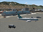
Googly scenery for WAML Palu/Mutiara, Indonesia. In Flight Simulator 2004 little
is provided other than a runway at this small domestic airport, although in the
real world it sees regular jet flights from airlines such as Batavia Air, Bouraq
Indonesia Airlines, Garuda Citylink, Lion Airlines and Merpati Nusentara and
smaller aircraft from operators like Airfast Service and Indonesia Air Transport.
These scenery files add aprons, taxiways, buildings and other airport features
to Flight Simulator's limited representation and allow "AI" traffic to land,
taxi, park and take off in a realistic manner.
The scenery does not purport to be ultra-accurate. Based on high-detail satellite
imagery from Google Earth, the layout is proportionally correct but the added
airport features, such as buildings, are built from default Microsoft objects
and add-on libraries so will not look exactly like the real thing.
You are not obliged to download and install any additional scenery libraries,
but to enjoy this scenery in its entirety, you may wish to. It will work fine,
with or without.
| Filename: | WAML_PaluMutiara_Indonesia.zip |
| License: | Freeware |
| Added: | 15th May 2010, 01:11:30 |
| Downloads: | 1,770 |
| Author: | John Hinson |
| Size: | 140.88 KB |
| Category: Flight Simulator 2004 - Scenery | |
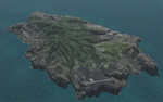
| PASY - Shemya (Eareckson Air Station) - Alaska, USA |
|
Images related to this file:
File Description:
Shemya is pretty well AT the western end of the Aleutian chain of islands in Alaska, around 240 miles west of Amchitka. There is no town on Shemya and the whole island is occupied (and owned) by the Air Force. There are three runways, two of which are from the 1940's and are now unused; in fact one of them has been partly ploughed up and also used for outdoor storage. The single in-use runway is aligned 10-28 and is 10,000 feet of 150 feet wide asphalt with an ils on 28, the runway that is used 99% of the time. The base is now not active but is maintained as a refuelling facility, so for landing and takeoff purposes it is open. The older and now unused areas are those where the hangers are slowly rusting away and the asphalt is turning green with encroaching and well-watered wildlife plants. The tower is now closed, so there is no atc and you just announce your intentions. Read the history of Shemya, a lot happened there.
| Filename: | PASY__Shemya_Eareckson_Air_Station__Alaska_USA.zip |
| License: | Freeware, limited distribution |
| Added: | 18th February 2015, 19:52:36 |
| Downloads: | 451 |
| Author: | Roger Wensley |
| Size: | 8.81 MB |
| Category: Flight Simulator 2004 - Scenery | |
| Seldovia PASO in Alaska US |
|
Images related to this file:
File Description:
Seldovia is a small airfield across the Kachemak Bay from Homer, 15 miles to the south. The runway is gravel and without lighting; the runway edges and the apron edges are marked by cones. The runway in real life is aligned 16-34 and is just over 1,800 feet, increased here to 2,200 feet to accomodate FS9 AI plane capabilities. The video is one of a series that are well worth watching and this one demonstrates the technique of short field landing and take off.
There is AI, with flights between Homer and Seldovia. I should mention here that the I can only make scenery to fit into my version of FS9, and probably your version is not exactly the same. Also, you may not have the planes that I have used for AI. Unfortunately I cannot cater for something I do not have myself. Homer PAHO will follow on from this post. If you find an error email me please, and note that my email address has been changed to rogwens at Gmail dot com.
| Filename: | Seldovia_PASO_in_Alaska_US.zip |
| License: | Freeware, limited distribution |
| Added: | 28th July 2021, 03:30:16 |
| Downloads: | 76 |
| Author: | Roger Wensley |
| Size: | 9.66 MB |
| Category: Flight Simulator 2004 - Scenery | |
| FHSH - St. Helena Island & Airport - St. Helena, South Atlantic |
|
Images related to this file:
File Description:
This project is a port of my FSX release of the the new airport (FHSH) on St. Helena Island. This scenery provides more accurate coastlines and roads, as well as corrected landclass based on the latest available satellite imagery. Flight plans are provided for the proposed commercial service to St. Helena, and some additional GA and military flights to the island are added as well.
The FS2004 St. Helena (FHSH) airport was created by aligning master plans for the airport with current satellite data and by studying many of the pictures that have been posted as the airport has taken shape. The official opening of the real airport on May 21, 2016, has been pushed back for more field tests due to challenging crosswinds. Updates were created or rebuilt in a manner which carefully aligns airport data with current satellite imagery. Scenery was created using Airport Design Editor 9 v1.67.5684 and SBuilder. Scenery objects were added and modified from stock FS9 scenery to resemble as closely as possible the actual airports.
| Filename: | FHSH__St_Helena_Island__Airport__St_Helena_South_A.zip |
| License: | Freeware |
| Added: | 5th May 2016, 07:44:38 |
| Downloads: | 2,229 |
| Author: | Carlyle Sharpe |
| Size: | 1.62 MB |
| Category: Flight Simulator 2004 - Scenery | |
| DTTR El Borma, Tunisia |
|
File Description:
Googly scenery for El Borma (ICAO: DTTR, IATA: EBM), a small airport with a
long runway deep in the Tunisian desert near the Algerian border. El Borma,
also known as Al Borma or Al Burmah is one of Tunisia's top onshore oil and
natural gas sources and it is this that probably justifies the twice-weekly
flights operated by ATR turboprops of Sevenair.
Microsoft have only provided runways at this airport in Flight Simulator
2004 and this scenery seeks to redress the situation so that you and your
"AI" traffic can use the airport realistically.
The scenery does not purport to be ultra-accurate. Based on high quality
satellite imagery from Google Earth, the layout is proportionally correct but the
added airport features, such as buildings, are built from default Microsoft objects
and add-on libraries so will not look exactly like the real thing.
You are not obliged to download and install any additional scenery libraries,
but to enjoy this scenery in its entirety, you may wish to. It will work fine,
with or without.
| Filename: | DTTR_El_Borma_Tunisia.zip |
| License: | Freeware |
| Added: | 17th December 2008, 16:49:15 |
| Downloads: | 1,027 |
| Author: | John Hinson |
| Size: | 58.32 KB |
| Category: Flight Simulator 2004 - Scenery | |
| Eagle County (KEGE), Glenwood Springs (KGWS), Colorado, Photo-Scenery (FS9 & FSX) |
|
Images related to this file:
File Description:
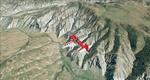
To explore this region depart from Eagle County Regional Airport (KEGE) which is a popular regional airport used in winter to transport skiers to nearby Vail. Northwest of the airport you can see the pit gypsum mine of American Gypsum which produces a variety of wallboard products. When you fly to the west and along the Eagle River, you soon pass its confluence with the Colorado River. Further west you can fly along Glennwood Canyon and finally reach Glennwood Springs where the Colorado meets the Roaring Fork River. Here you can turn south and fly direct Glenwood Springs Airport (KGWS) which lies south of the city. This scenery brings you another 3.500 sq km of beautiful Colorado in 4.7m/pix quality.
High resolution versions of this scenery for FS9 and FSX (much sharper, but larger and multiple downloads) are available at www.blueskyscenery.com/GNB_SouthWest2.html . The screenies are taken from the high-res versions, so expect this version to be slightly more blurry. YourDonation@Work: Dedicated to Alain and James.
| Filename: | Eagle_County_KEGE_Glenwood_Springs_KGWS_Colorado_P.zip |
| License: | Freeware, limited distribution |
| Added: | 30th January 2010, 17:01:49 |
| Downloads: | 2,706 |
| Author: | Gottfried Razek - blueskyscenery.com |
| Size: | 93.8 MB |
| Category: Flight Simulator 2004 - Scenery | |
| VAAH Ahmedabad International, India |
|
Images related to this file:
File Description:

Googly scenery for VAAH Ahmedabad International, India - an enhancement to the airport provided in Flight Simulator 2004 which is incorrect in many respects. These scenery files correct and improve the terminal location, apron, taxiways, buildings and other airport features so that you and your "AI" traffic can land, taxi, park and take off in a realistic manner.
The airport is served by aircraft as large as Jumbo Jets from a range of domestic and international Indian airline operators, together with flights from other countries' airlines such as Kuwait Airways and Singapore Airlines.
The scenery does not purport to be ultra-accurate. Based on high-detail satellite imagery from Google Earth, the layout is proportionally correct but the added airport features, such as buildings, are built from default Microsoft objects and add-on libraries so will not look like the real thing.
You are not obliged to download and install any additional scenery libraries, but to enjoy this scenery in its entirety, you may wish to. It will work fine, with or without.
[File re-uploaded at request of AVSIM]
| Filename: | VAAH_Ahmedabad_International_India.zip |
| License: | Freeware |
| Added: | 26th June 2010, 06:06:36 |
| Downloads: | 2,921 |
| Author: | John Hinson |
| Size: | 82.47 KB |
| Category: Flight Simulator 2004 - Scenery | |
| Groom Lake / Area 51 Scenery - KXTA |
|
File Description:
This package will add the missing Area 51 airport (credited as KXTA according to some sources) to Flight Simulator 2004: A Century of Flight. It will add the following items, but YOU CONTROL IF THEY ARE ACTIVE IN FS2004 via the scenery library (directions are included in the manual):
* KXTA in the proper location with assocated scenery including airport buildings, antenna arrays on Bald Mountain and Papoose Mountain, even an SUV in the general location of "Freedom Ridge"; the one time favortie observation point for civilians wanting to keep an eye on what our "Uncle" is up to out there in the desert.
* New KLAS, KLSV, and KINS to add appropriate parking (Again you don't HAVE to use them, so if you already have a MOD for one of these, you can simply elect not to activate mine)
* New skin for the default 737-400 in EG&G Janet colors.
* AI F-22 Raptor
* AI Flight plans for the F22s and Janet 737s (Janet flights based on real world schedules as found at www.dreamlandresort.com)
| Filename: | Groom_Lake__Area_51_Scenery__KXTA.zip |
| License: | Freeware |
| Added: | 2nd March 2008, 02:07:17 |
| Downloads: | 4,618 |
| Author: | Ted Thompson |
| Size: | 5.26 MB |
© 2001-2026 AVSIM Online
All Rights Reserved
Privacy Policy |