
Where Flight Simulation Enthusiasts Gather from Around the World!
AVSIM Library - Search Results

| Category: Flight Simulator 2004 - Scenery | |
| Cape Verde - GVBA |

|
File Description:
A simple scenery replacing the stock airport with a runway only.
| Filename: | Cape_Verde__GVBA.zip |
| License: | Freeware |
| Added: | 27th December 2013, 21:20:48 |
| Downloads: | 587 |
| Author: | Victor Cabral |
| Size: | 952.51 KB |
| Category: Flight Simulator 2004 - Scenery | |
| Lac Caché, Gaspé, Québec Short Hops |
|
File Description:
Lac Caché is a fictitious scenery, situated between Bonaventure and Gaspé Québec, Canada. Docking facilities plus a grass strip for smaller planes and light twins. A waterfall and a few of the village buildings with lots of candies.
| Filename: | Lac_Cach__Gasp____Qubec_Short_Hops.zip |
| License: | Freeware |
| Added: | 14th September 2004, 03:34:30 |
| Downloads: | 1,538 |
| Author: | Leon Louis |
| Size: | 4.51 MB |
| Category: Flight Simulator 2004 - Scenery | |
| Tom Field Airport |
|
File Description:
Tom Field Airport is a small fictional airport located east of Miami, Florida. It was originally a test project but soon changed to become a fun small airport. Developed on gmax, Tom Field Airport has a low FPS impact which provides for a smooth flight. Refer to read me for more information.
| Filename: | Tom_Field_Airport.zip |
| License: | Freeware, limited distribution |
| Added: | 9th February 2009, 00:38:34 |
| Downloads: | 312 |
| Author: | Rosario Resta |
| Size: | 8.28 MB |
| Category: Flight Simulator 2004 - Scenery | |
| Woody's EZ Airport Signs |
|
File Description:
This is a file with a lot of signs for in and around airports to help you to make it seem a little more real.
| Filename: | Woodys_EZ_Airport_Signs.zip |
| License: | Freeware, limited distribution |
| Added: | 22nd January 2009, 20:14:37 |
| Downloads: | 1,005 |
| Author: | Glenn "woody" Fout |
| Size: | 172.3 KB |
| Category: Flight Simulator 2004 - Scenery | |
| Ubatuba (SDUB) Afcad |
|
Images related to this file:
File Description:
This is the afcad file for Ubatuba (SDUB) airport, located in Brazil's southwest area in a very beautiful place with pretty beaches. As a suggestion, take a short flight in a slow airplane from Ubatuba (SDUB) to Angra dos Reis (SBAG).
| Filename: | Ubatuba_SDUB_Afcad.zip |
| License: | Freeware |
| Added: | 21st May 2010, 03:27:18 |
| Downloads: | 1,225 |
| Author: | Felipe Bachian |
| Size: | 2.84 KB |
| Category: Flight Simulator 2004 - Scenery | |
| Chistochina, Alaska CZO |
|
File Description:
Chistochina is a small airport off of the Glenn Highway just northeast from Gulkana. This scenery was built using the default strip, so all of your flightplanning goodies will still work. There is a freight office, a repair hangar, a bar and grill / pool hall, a small trading post, a doctor's office and an ammo shop. Truckers also use these facilities, so the little airport is well known. Please enjoy!
| Filename: | Chistochina_Alaska_CZO.zip |
| License: | Freeware, limited distribution |
| Added: | 2nd February 2004, 14:47:08 |
| Downloads: | 3,369 |
| Author: | Don Moser |
| Size: | 2.06 MB |
| Category: Flight Simulator 2004 - Scenery | |
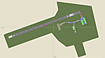
| Gander CYQX in Newfoundland Canada |
|
Images related to this file:
File Description:
Gandeer is on the east coast of Canada and is the closest North American airport to Europe on the great circle route. In the early days of transatlantic flight, and in fact into the 1960's, this made it very important as a refueling stop either before the ocean hop or just after. Since then it's importance as an airport has faded somewhat as planes now fly directly to the larger city destinations. It is still an active air force base for ocean patrol and search and rescue planes, and military flights are around half of the total flights into and out of the airport. The main attractions of the airport now are the long runways and the cheaper landing fees, and there are some cargo flights and cheap charter passenger flights. This version of Gander is based upon a forgotten-about video taken in October 2010. By then the two longer runways, 13-31 at 8,900 feet and 03-21 at 10,200 feet (though in FS9 this is still designated 04-22, as it had been in 2003) had been closed (one at a time) and totally resurfaced. The third runway 09-27 (3,500 feet in 2003) was closed and starting the process of being broken up, along with associated aprons. This was part of a long process of demolition of some of the older buildings, aprons, and taxiways as they became unused with the fall in the number of daily flights. I have made it clear which of the 2010 taxiways and aprons were still in use by showing them as asphalt, while those in the process of decaying disuse or removal are in the darker tarmac texture; this is somewhat realistic as when asphalt aprons are "ploughed" for removal the darker underside becomes visible. In the renovation process of taxiway repairs only the centre strip of the taxiways was repaired and this is marked by new and closer edge lines. One end of the closed runway was still being used in 2010 for access and parking. There is a warning note in the April 2010 edition of the NAV CANADA Flight Supplement that states "surface rut on Gander Flight Training's private taxiway" (written with extremely shortened words). The Gander layout page is included here, showing that in the Spring of 2010 a much-shortened version (1,875 feet) of the 09-27 runway was still in use; my version is for late 2010 and after that runway was closed. The older buildings (and some of them are now 70 years old or more) are built in concrete and flat roofed with bitumen water proofing; hence the almost black roofs. The terminal building is one of these, though it has been enlarged by the inclusion of a hangar that is now used as the main terminal space. Almost all of the buildings are correctly replicated here. The main GA parking area is to the east of 03-21 where there are two large hangar buildings. One of them is for maintenance and the other is for a large FBO called Gander Aviation. There are other FBO's on the airport, closer to the terminal. These are Irving and Woodward, both to the west, and Allied to the south. There is a further FBO at the eastern end of the apron, name unknown. Shell, who only did refueling, were next to Woodward in 2010 but left, I believe, in 2012. The large red building behind Woodward and Shell is for the maintenance of all airport equipment (from luggage trolleys, snow clearers, de-icing trucks etc to air conditioning, radar, and radios). Most of the remaining buildings are for the air force base, though there are some private companies (such as Universal Helicopters) and even a small private cottage.
| Filename: | Gander_CYQX_in_Newfoundland_Canada.zip |
| License: | Freeware, limited distribution |
| Added: | 29th April 2020, 19:15:01 |
| Downloads: | 665 |
| Author: | Roger Wensley |
| Size: | 29.37 MB |
| Category: Flight Simulator 2004 - Scenery | |
| Pensacola, Florida KPNS |
|
File Description:
This is a simple upgrade to Pensacola Int'l Airport. There is a new terminal building, jetways, vehicles, and a new AFCAD including Rwy 8/26's recent extension.
| Filename: | Pensacola_Florida_KPNS.zip |
| License: | Freeware |
| Added: | 24th July 2006, 13:53:54 |
| Downloads: | 5,219 |
| Author: | William Morgan / FRF Studio |
| Size: | 1.43 MB |
| Category: Flight Simulator 2004 - Scenery | |
| Hiline Lake/Alaska Cub Club |
|
File Description:
Hiline Lake is a fictional scenery located 51 miles WNW of Anchorage, Alaska. It's the home of a recreational facility owned by "The Alaska Piper Cub Owners Assn." (a fictional orginazation) and is known locally as "The Alaska Cub Club". The area has a 1300ft. dirt strip and a floatplane dock. The "Cub Club" is open to the public and you don't have to fly a "Cub" to visit. We hope you enjoy your stay!
| Filename: | Hiline_LakeAlaska_Cub_Club.zip |
| License: | Freeware, limited distribution |
| Added: | 29th March 2004, 14:19:20 |
| Downloads: | 1,573 |
| Author: | Tom Fica |
| Size: | 2.23 MB |
| Category: Flight Simulator 2004 - Scenery | |
| Vancouver Area Landclass |
|
File Description:
Includes a landclass and a waterclass file for the Vancouver area and Fraser River.
| Filename: | Vancouver_Area_Landclass.zip |
| License: | Freeware |
| Added: | 6th November 2003, 22:41:17 |
| Downloads: | 2,652 |
| Author: | Jesse Wheeler |
| Size: | 1.86 KB |
© 2001-2026 AVSIM Online
All Rights Reserved
Privacy Policy |