
Where Flight Simulation Enthusiasts Gather from Around the World!
AVSIM Library - Search Results

| Category: Flight Simulator 2004 - Scenery | |
| Animated Crash Tender for Paris Le Bourget 1960 (LFPB) |

|
Images related to this file:
File Description:
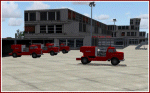
We have produced a moving French crashtender and also static ones as an extension for the existing LFPB 1960 Paris Le Bourget Version2 Scenery by Wolfgang Gersch, Volker Boehme and Rui Cristina.
You must have this scenery installed, which is available here as lfpb_1960_paris_le_bourget.zip
| Filename: | Animated_Crash_Tender_for_Paris_Le_Bourget_1960_LF.zip |
| License: | Freeware, limited distribution |
| Added: | 1st December 2013, 01:56:51 |
| Downloads: | 1,001 |
| Author: | Harry Biard, Jaap de Baare and Bernhard Leuenberger |
| Size: | 491.84 KB |
| Category: Flight Simulator 2004 - Scenery | |
| Sao Luis (Brazil) - Photoreal |
|
Images related to this file:
File Description:
Sao Luis is a Brazilian city, capital of Maranhao state, founded on September 8, 1612. It is located on the island Upaon-Acu (the name was given by the Indians tupinambas meaning "Big Island"), South Atlantic, between the bays of San Marcos and San Jose. It is one of three Brazilian state capitals located on islands (the others are Florianopolis and Vitoria). The scenery contains:
Photoreal of Sao Luis island with hand placed autogen; Marechal Cunha Machado Intl. Airport photoreal in HD; real lighting effect; grass textures; AZL with detailed buildings and hangars; ground support vehicles; detailed terminal with fingers; ships on the coast; Itaqui harbor.
# Courtesy of Marco Santiago (Addons): Bridges Pres. Sarney, Bandeira Tribuzi and the Estreito dos Mosquitos; Terminal de Integracao BR; Alexandre Raposo aerodrome; CAVU aerodrome (Ultralight).
| Filename: | Sao_Luis_Brazil__Photoreal.zip |
| License: | Freeware, limited distribution |
| Added: | 4th December 2010, 03:58:01 |
| Downloads: | 2,726 |
| Author: | Jorge Amengol |
| Size: | 60.29 MB |
| Category: Flight Simulator 2004 - Scenery | |
| FS2004 Scenery-UD21 (UG0C)-Nor Hachn-Arzni AB (A. Khanperyants Armenian Military Aviation University) and related Traffic |
|
File Description:
FS2004 Scenery-UD21 (UG0C)-Nor Hachn-Arzni AB (A. Khanperyants Armenian Military Aviation
University) and related Traffic. Based on open photos available and Ultimate Terrain Europe.
Please see Install notes for necessary object files and enjoy.
| Filename: | FS2004_SceneryUD21_UG0CNor_HachnArzni_AB_A_Khanper.zip |
| License: | Freeware |
| Added: | 10th March 2023, 02:18:31 |
| Downloads: | 29 |
| Author: | Bernd Barsch |
| Size: | 3.72 MB |
| Category: Flight Simulator 2004 - Scenery | |
| FS2004 Scenery-UD21 (UG0C)-Nor Hachn-Arzni AB (A. Khanperyants Armenian Military Aviation University) and related Traffic |
|
File Description:
FS2004 Scenery-UD21 (UG0C)-Nor Hachn-Arzni AB (A. Khanperyants Armenian Military Aviation
University) and related Traffic. Based on open photos available and Ultimate Terrain Europe.
Please see Install notes for necessary object files and enjoy.
| Filename: | FS2004_SceneryUD21_UG0CNor_HachnArzni_AB_A_Khanper.zip |
| License: | Freeware |
| Added: | 10th March 2023, 02:40:11 |
| Downloads: | 94 |
| Author: | Bernd Barsch |
| Size: | 3.72 MB |
| Category: Flight Simulator 2004 - Scenery | |
| VGCB Cox's Bazar, Bangladesh |
|
File Description:
Googly scenery for VGCB Cox's Bazar, Bangladesh, a small domestic airport
serving the fishing town of the same name in the Bay of Bengal, to the
south of Chittagong. It boasts extensive sandy beaches which has allowed
tourism development. The unusual name comes from Captain Hiram Cox of the
British East India Company who was appointed Superintendent of the outpost
in the late 1700s. The airport, which was originally a Pakistan Air Force
base, sees domestic flights (mostly to/from Dhaka) operated by Hawker
Siddeley 748s, de Havilland Dash 8s and Fokker Fellowship aircraft of Biman
Bangladesh Airlines, GMG Airlines, United Airways and Zoom Airlines.
Flight Simulator 2004 has made no provision for traffic with only a runway
provided and this scenery seeks to redress the situation.
The scenery does not purport to be ultra-accurate. Based on high quality
satellite imagery from Google Earth, the layout is proportionally correct but the
added airport features, such as buildings, are built from default Microsoft objects
and add-on libraries so will not look exactly like the real thing.
You are not obliged to download and install any additional scenery libraries,
but to enjoy this scenery in its entirety, you may wish to. It will work fine,
with or without.
| Filename: | VGCB_Coxs_Bazar_Bangladesh.zip |
| License: | Freeware |
| Added: | 14th April 2008, 21:13:08 |
| Downloads: | 1,348 |
| Author: | John Hinson |
| Size: | 67.71 KB |
| Category: Flight Simulator 2004 - Scenery | |
| Colville Lake CEB3 in Northwest Territories Canada |
|
Images related to this file:
File Description:
Colville Lake is a small village of around 150 Dene, located to the northwest of the Great Bear Lake and east of the Mackenzie River, 120 miles north of Norman Wells. The village and the airfield are next to each other and to the lake shore. I recently discovered which of the standard terminal buildings had been used there and this, along with information I already had, enabled me to now make the scenery, which is based on an approximate 2010 date. The gravel runway is lit and around 2,800 feet long, aligned 10-28. North Wright Air serves the village from it's headquarters at Norman Wells with daily flights by de Havilland Twin Otters, or "twotters" as they were quickly named among the northern Canadian airline personnel when they were first produced. The approximate time of this scenery is 2010. While testing this scenery I discovered that Tulita (previously called Fort Norman) which is another Mackenzie River airfield to the south of Norman Wells, needs to be reposted due to a terrain fault. If you find an error here then email me please, and note that my email address has been changed to rogwens at Gmail dot com.
| Filename: | Colville_Lake_CEB3_in_Northwest_Territories_Canada.zip |
| License: | Freeware, limited distribution |
| Added: | 31st July 2021, 18:23:48 |
| Downloads: | 68 |
| Author: | Roger Wensley |
| Size: | 4.51 MB |
| Category: Flight Simulator 2004 - Scenery | |
| Lisbon Airport 1959 (LPPT) |
|
File Description:
Detailed scenery for Lisbon Airport circa 1959. Lisbon Airport (LPPT) is the largest airport in Portugal. While Lisbon was a critical stop on the early flying boat route across the South Atlantic, at the end of the 1950s Lisbon Airport itself was still important as a European gateway, particularly for South American and African traffic. Lisbon Airport, which in that period handled a total of almost 21,000 aircraft movements (12,600 of which were by commercial aircraft), was used regularly by no fewer than 21 international airlines.
| Filename: | Lisbon_Airport_1959_LPPT.zip |
| License: | Freeware, limited distribution |
| Added: | 1st February 2009, 02:26:02 |
| Downloads: | 3,755 |
| Author: | Harry Biard, Jaap de Baare, Wolfgang Gersch and Tom Gibson |
| Size: | 197.1 KB |
| Category: Flight Simulator 2004 - Scenery | |
| YSSY 1961 Sydney Kingsford Smith Intl |
|
File Description:
Sydney Airport (also known as Kingsford Smith International Airport),
is located in the Sydney suburb of Mascot.
It is the major airport serving Sydney.
Sydney Airport is one of the oldest continually operated airports
in the world, and the busiest airport in Australia.
Originally declared an aerodrome in 1920 (then known as Sydney Airport),
it was renamed Sydney (Kingsford Smith) International Airport in 1953,
in honour of Charles Kingsford Smith, a pioneering Australian aviator.
The airport's first runways were built in 1933, all in gravel.
| Filename: | YSSY_1961_Sydney_Kingsford_Smith_Intl.zip |
| License: | Freeware |
| Added: | 6th November 2008, 03:55:54 |
| Downloads: | 3,114 |
| Author: | Wolfgang Gersch, Jaap de Baare, Tom Gibson and Adrian Wainer |
| Size: | 1.05 MB |
| Category: Flight Simulator 2004 - Scenery | |
| Avon STOLPort (KWHR) |
|
File Description:
A recreation of the Avon STOLPort (ident KWHR) for MS Flight Simulator 2004, A Century of Flight. Avon was operated as an exclusive destination for Rocky Mountain Airways between (approximately) 1978 and sometime in the late 80's or early 90's. The 4,000' runway was short for the nearly 7,500' elevation, and surrounded by mountains, some towering over 6,000' above the airport elevation. To allow all weather operation, the airport eventually featured what was reported as the steepest ILS ever constructed, with a seven degree glideslope. RMA had exclusive use of the tiny STOLPort and operated it with 50-passenger De Haviland Dash 7 equipement.
Lacking the original chart, I surveyed in FS and plotted what is hopefully an accurate representation of the ILS approach, using my best understanding of TERPS - the US standard for instrument approaches. I also created an NOS-style IAP chart of this approach for the package. A text Takeoff Minimums & Procedure is also included.
AI ATC & traffic recognition of the approach will hopefully follow, but does not exist yet. In other words, you can fly this approach and see the localizer in the GPS, but AI ATC will not give you vectors to it. You'll need to follow the full procedure included on the chart.
Please see the full Readme.txt in "Flight Simulator 9\Addon Scenery\KWHR\Docs" in this zipfile for information on installation of the scenery, flying the approach, and more on the history of the Avon STOLPort.
| Filename: | Avon_STOLPort_KWHR.zip |
| License: | Freeware, limited distribution |
| Added: | 12th May 2008, 23:14:38 |
| Downloads: | 418 |
| Author: | Stephen Comer |
| Size: | 2.1 MB |
| Category: Flight Simulator 2004 - Scenery | |
| Air Saguenay floatbase Lac Sebastien CTD3 in Quebec Canada |
|
Images related to this file:
File Description:
This is the first of five sceneries around Lac Saint-Jean in Quebec, Canada, to the west of the St Lawrence River and close to Bagotville air base. Air Saguenay are a mainly float plane company that operates hunting and fishing flights to company-owned outposts in northern Quebec, with a fleet of almost 30 aircraft including 11 de Havilland Otters and 14 Beavers as of the last count. Their HQ float base is on Lac Sebastien, which is 30 miles east of the far larger Lac Saint-Jean. There are screenshots of this scenery and others in the series that follow this post in the Lac Saint-Jean QC folder. This scenery includes in the AI an Air Saguenay turbine Otter on floats, which has been modified to operate as an AI floatplane with a new config file. The ai also includes other GA float planes. There are also planes listed that will be required only for the future posts in this series, and the relevant textures etc will be provided at the date of the posts. Some of the Beaver AI planes will only be available if you already have the aerosoft Beaver installed. There are HTAI planes used as AI in this series, updated by Nick Tselepides, and the float planes for this part of the series are included here, Cessna 185's.
| Filename: | Air_Saguenay_floatbase_Lac_Sebastien_CTD3_in_Quebe.zip |
| License: | Freeware, limited distribution |
| Added: | 4th November 2017, 07:15:09 |
| Downloads: | 292 |
| Author: | Roger Wensley |
| Size: | 11.79 MB |
© 2001-2026 AVSIM Online
All Rights Reserved
Privacy Policy |