
Where Flight Simulation Enthusiasts Gather from Around the World!
AVSIM Library - Search Results

| Category: Flight Simulator 2004 - Scenery | |
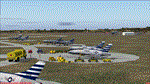
| Fly Balaton, Sarmellek (LHSM) - Hungary |

|
File Description:
Semellek opened in 1951. Hungary's fifth international airport and third busiest. Dunantul largest and its most important airport. It is a daylong opening hour. 6 airlines fly from 4 countries onto Sarmellek in 2008 of its summers.
| Filename: | Fly_Balaton_Sarmellek_LHSM__Hungary.zip |
| License: | Freeware |
| Added: | 29th March 2008, 15:37:15 |
| Downloads: | 2,348 |
| Author: | Monika Orosz |
| Size: | 8.15 MB |
| Category: Flight Simulator 2004 - Scenery | |
| Stuttgart, Germany (EDDS) |
|
File Description:
A detailed freeware scenery of EDDS Stuttgart, an international airport in south west Germany, optimized for high frame rates. The ground layout should mostly be compatible to the German Airports Version of EDDS. Read the readme file!
| Filename: | Stuttgart_Germany_EDDS.zip |
| License: | Freeware |
| Added: | 31st March 2006, 00:18:43 |
| Downloads: | 27,041 |
| Author: | Georg Aubele |
| Size: | 2.16 MB |
| Category: Flight Simulator 2004 - Scenery | |
| SBSG - New Airport Gov Aluizio Alves Int'l - Natal, Brazil |
|
File Description:
Natal, Brazil - SBSG - has a new airport moved out of old Natal airport (SBNT). I created scenery with new update Google Earth image. Please check with my readme.txt for additional information with flightplans and add new airport.
| Filename: | SBSG__New_Airport_Gov_Aluizio_Alves_Intl__Natal_Br.zip |
| License: | Freeware |
| Added: | 14th October 2015, 15:43:45 |
| Downloads: | 3,104 |
| Author: | Stuart John Gilbert II |
| Size: | 2.43 MB |
| Category: Flight Simulator 2004 - Scenery | |
| EHAM - Moving Traffic v0.5 |
|
File Description:
This project contains moving traffic around Schiphol Airport (EHAM). There are 4 types of cars and more than 10 colour schemes.
With this project there is just 1 problem:
Traffic will only appear in the first half of the hour. This time is the time of FS, not your system time. After 30 minutes of traffic all cars will disappear. The next 30 minutes it's rather quiet. This means a traffic density of zero. After this 30 minute period, it's rush (half)hour again. This repeats itself.
We don't know the problem yet, but any help is welcome. Some minor problems will be fixed later. This version (v0.5) is the release version because we don't want you to wait any longer.
We hope you'll enjoy this addon in spite of this problem. For other projects or updates: ProjectX
| Filename: | EHAM__Moving_Traffic_v05.zip |
| License: | Freeware |
| Added: | 22nd April 2005, 15:51:58 |
| Downloads: | 5,957 |
| Author: | Paul Koopman, André Koopman, ProjectX |
| Size: | 462.81 KB |
| Category: Flight Simulator 2004 - Scenery | |
| LFJA Chaumont_Semoutiers AB |
|
Images related to this file:
File Description:
From 1950 to 1967 the USAF set up and maintained bases in France, with the agreement of the French government, as part of its commitment to the North Atlantic Treaty Organisation. Chaumont AB was one of the ten main air bases which supported both attack and air defence capabilities. Many people do not appreciate the sheer extent of the USAF bases in France at this time and the reasons leading to the USAF departure in 1967. There is a link to a fine article on all this included.
This scenery and traffic represent Chaoumont Air Base during the years 1955 to 1962. Custom Tower and Hangars by Dan French along with a large number of custom paints by DeltataDart for the many types of aircraft represented over this period. Traffic files and the aircraft and paints needed are provided for 1955 (including the Skyblazer Demonstration Team), 1957, 1959 and 1962.
| Filename: | LFJA_Chaumont_Semoutiers_AB.zip |
| License: | Freeware |
| Added: | 22nd November 2023, 16:08:16 |
| Downloads: | 109 |
| Author: | Al von Pingel, Ken Lawson, Dan French, DeltaDart |
| Size: | 38.9 MB |
| Category: Flight Simulator 2004 - Scenery | |
| Kangiqsujuaq CYKF in northern Quebec, Canada |
|
Images related to this file:
File Description:
Kangiqsujuaq is on the north coast of Quebec, 85 miles west of Quaqtaq and 125 miles east of Salluit, while across the Hudson Strait and 100 miles away on Baffin Island is Kimmirut. The town grew around two trading posts, the first opened by Revillon Freres in 1910, and the second by the Hudson Bay Company in 1914. A school was opened in 1960, and a clinic in 1961. The town was known as Wakeham Bay until 1961, and now has a population of around 700. The airport is to the south of the town and up on the hill at 511 feet ASL (this has been remeasured since 2004 and is now known to be 501). The gravel runway is just over 3,500 feet long and aligned 15/33; there is no PAPI, but there is fuel available, both 100LL and JetA. There are flights by Air Inuit.
| Filename: | Kangiqsujuaq_CYKF_in_northern_Quebec_Canada.zip |
| License: | Freeware, limited distribution |
| Added: | 27th January 2013, 00:55:00 |
| Downloads: | 231 |
| Author: | Roger Wensley |
| Size: | 2.31 MB |
| Category: Flight Simulator 2004 - Scenery | |
| OIBJ Jam/Tohid, Iran |
|
File Description:
Googly scenery for OIBJ Jam/Tohid - a small Iranian domestic airport for which
nothing more than a runway is provided in Flight Simulator 2004. These scenery
files add taxiways, aprons, buildings and other airport features so that you
and your "AI" traffic can land, taxi, park and take off in a realistic manner.
The airport is served about twice per week by Fokker jets of Iran Air.
The scenery does not purport to be ultra-accurate. Based on high-detail satellite
imagery from Google Earth, the layout is proportionally correct but the added
airport features, such as buildings, are built from default Microsoft objects
and add-on libraries so will not look like the real thing.
You are not obliged to download and install any additional scenery libraries,
but to enjoy this scenery in its entirety, you may wish to. It will work fine,
with or without.
| Filename: | OIBJ_JamTohid_Iran.zip |
| License: | Freeware |
| Added: | 8th July 2007, 21:19:39 |
| Downloads: | 1,020 |
| Author: | John Hinson |
| Size: | 80.11 KB |
| Category: Flight Simulator 2004 - Scenery | |
| Vancouver Island and Inner Passage float bases in BC, Canada |
|
File Description:
This is a series of float bases to the east of the northern part of Vancouver Island. They are all zipped together because: first, they are all in the same geographical area and if you like one you may like them all; second it means I only write one set of notes; and third I only upload once. I was looking to fill in the gap between what Holger Sandmann and his cohorts have done with Alaska, and Vancouver and Vancouver Island to the south, and there are these 16 float bases in a stretch of 180 miles between the northern part of Vancouver Island and the mainland coast. And if you leave out the relatively isolated Rivers Inlet to the north then they are all within a 140 mile stretch. Some are on the east coast of Vancouver Island, but most are on islands between the mainland and the island.
| Filename: | Vancouver_Island_and_Inner_Passage_float_bases_in_.zip |
| License: | Freeware |
| Added: | 3rd August 2008, 06:03:09 |
| Downloads: | 1,870 |
| Author: | Roger Wensley & Jim Turner |
| Size: | 6.85 MB |
| Category: Flight Simulator 2004 - Scenery | |
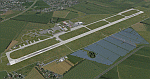
| IONE, Washington - S23 - Airport and adjacent scenery |
|
Images related to this file:
File Description:
Ione is a small airport close to the Washington-Canadian border, about 60 nm North of KSFF (Felts). The ICAO code S23. It now has NDB and VOR; frequencies for these are NDB- 379, VOR-113.20. This airport is an enhanced version of the default S23. It handles small AC only. This is for FS9.
This project started out as an enhancement for my ski-patrol bro who lives in Ione and grew into a major project. This project has four, basic major parts -
1. the airport itself.
2. back road area with a few farm houses, gas station and church.
3. small town - courtesy of Opa Marshall who spent much time with me on suggestions and guidance.
4. Camp ground area.
We hope you will enjoy this work. Readme file has contact info and airport ID of some close by airports. Bob
| Filename: | IONE_Washington__S23__Airport_and_adjacent_scenery.zip |
| License: | Freeware |
| Added: | 2nd February 2010, 10:19:49 |
| Downloads: | 1,332 |
| Author: | Robert Lacy & David "Opa" Marshall |
| Size: | 2.06 MB |
| Category: Flight Simulator 2004 - Scenery | |
| LKTB - Brno Turany - Brno, Czech Republic |
|
Images related to this file:
File Description:
Brno - Turany Airport (IATA: BRQ, ICAO: LKTB) is an airport in Brno, Czech Republic.
The airport was built during the 1950s as a replacement for the old Brno airport located in Slatina
(north east of Turany airport). During the 1980s, the airport was handed over for use by the
Czechoslovak air force, and civil operations were reduced to a minimum. After the fall of communism
in 1989, the airport returned to civil use, and was operated by the state-owned Czech Airport
Authority.
At present, the South-Moravian local government owns the airport, and it is operated by a private
company, Brno Airport Ltd. Although charter and private flights still dominate at the airport, it has
seen significant growth of scheduled service in the last years. Currently, three airlines operate
scheduled passenger flights from the airport: Ryanair, UTair Aviation and Wizzair. Charter flights are
usually operated by Travel Service Airlines.
| Filename: | LKTB__Brno_Turany__Brno_Czech_Republic.zip |
| License: | Check within download |
| Added: | 28th May 2014, 10:59:20 |
| Downloads: | 1,137 |
| Author: | Martin Vseticek, Michal Krechowski, Peter Priskin |
| Size: | 11.15 MB |
© 2001-2026 AVSIM Online
All Rights Reserved
Privacy Policy |