
Where Flight Simulation Enthusiasts Gather from Around the World!
AVSIM Library - Search Results

| Category: Flight Simulator 2004 - Scenery | |
| "Caiolo" Sondrio Airport, Valtellina, North Italy |

|
Images related to this file:
File Description:
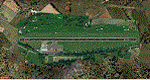
In this airport reside AvioValtellina and VolaValtellina, as well as the operational base of the Health Service 118 and Mountain Rescue. It also base of the Aeroclub Sondrio with its Flight School VDS. Site at the beginning of the Valtellina, in Caiolo municipality (N46 09.0 E09 48.0), has an asphalt runway from 1050x23 mts, ground communication frequency 129.50; ICAO code: LILO. It is also enclosed the base of INAER Aviation, located in Colico-Piantedo (N46 08.18 E09 24.19 - code LIEI), that operates in Medical Emergency, rescue operations in the mountains and off-shore. Scenery realized on the real cooordinates of the airport (except for elevation) including the scenery of the heliport INAER Colico. Requires the use of the libraries' dva51 "and the system of vegetations "TreePlanter".
Enjoy!
A presentation video is available here.
| Filename: | Caiolo_Sondrio_Airport_Valtellina_North_Italy.zip |
| License: | Freeware |
| Added: | 25th October 2014, 11:52:25 |
| Downloads: | 856 |
| Author: | Aldo Della Vedova |
| Size: | 29.5 MB |
| Category: Flight Simulator 2004 - Scenery | |
| The Bermudas Islands |
|
Images related to this file:
File Description:

The Bermudas islands are located in the middle Atlantic. Their main island is in the 32 15 71 N and 64 52 50 W.Is a very broken into fragments island that it is part of s cluster of 150 islands distributed in an area of 53 square kms
This archipielago like superior vertex together with Puerto Rico island and the city of Lauderade-Hollywood in Florida U.S.A. tey form the celebrates TRIANGLE OF BERMUDAS that in the time 50 ships and 20 airplanes have disappeared. Most of these disappareances they can be explained, other nr.
Nevertheless to the one West of the island and a near a carrier to 2000-3000
feet high approximately I have discovery some ships floating in the space.
Not you if they are part of the disappareances....But they are there.
Discover it your same one....
| Filename: | The_Bermudas_Islands.zip |
| License: | Freeware |
| Added: | 8th November 2010, 04:31:29 |
| Downloads: | 1,808 |
| Author: | Toni Agramont |
| Size: | 14 MB |
| Category: Flight Simulator 2004 - Scenery | |
| Himalayan Peaks Volume 2 - Mt. Everest photoreal textures |
|
File Description:
The photoreal textures in this package cover an area of about 100km (E/W) by 60km (N/S) featuring Mt. Everest and several neighboring peaks and are based on a Landsat 7 ETM 15-m multispectral image taken in October 2000. The relatively low resolution of the image makes for pretty grainy textures up close and I did not add any autogen, seasonal textures, or flattened water bodies. Nevertheless, I do believe the photoreal textures do a much better job at showing the grandiose alpine features of this area - rock faces, snow fields, glaciers, and bare ground - than generic landclass textures possibly can. The textures are placed for a best fit with our Mt. Everest area LOD10 terrain mesh, fs_him_01.zip, but probably work OK with the default LOD8 mesh of this area or third-party terrain mesh files.
| Filename: | Himalayan_Peaks_Volume_2__Mt_Everest_photoreal_tex.zip |
| License: | Freeware |
| Added: | 10th March 2010, 22:27:43 |
| Downloads: | 25,484 |
| Author: | Holger Sandmann |
| Size: | 75.71 MB |
| Category: Flight Simulator 2004 - Scenery | |
| YWKS - Wilkins Aerodrome, Antarctica |
|
File Description:
Wilkins Aerodrome is about 10 km west from Casey Station. The blue ice, snow-capped Wilkin's single runway is capable of supporting large wheeled aircraft. The runway operates during the summer period and is capable of supporting weekly flights from Australia. Australia made aviation history this year with the landing of its first passenger aircraft, an Airbus A319, in Antarctica at Wilkins Aerodrome. The A319-115LR, REG: VH-VHA, is operated by Skytraders Pty Ltd.
The scenery adds an AFCAD, flattens the area, and a small amount of buildings. The buildings are placed as close to real world locations as I could get. I only used generic FS9 objects for ease of distribution. The file can be edited with EZScenery. The file also includes a PDF of the most current charts and a KMZ file to view the real location in Google Earth.
| Filename: | YWKS__Wilkins_Aerodrome_Antarctica.zip |
| License: | Freeware |
| Added: | 4th July 2008, 19:38:57 |
| Downloads: | 1,363 |
| Author: | Brad Banister |
| Size: | 202.94 KB |
| Category: Flight Simulator 2004 - Scenery | |
| Delhi, India DEL / VIDP Version 3 |
|
Images related to this file:
File Description:

This is a complete remake of the Indira Gandhi Int'l Airport
in Delhi, India. All terminal and cargo buildings have been replaced and repositioned to be more accurate.
The parking assignments have been paistakingly input from special sources, so the scenery becomes
very realistic. New terminals 1D and T3 are represented and all parking and taxiways are 100% correct. This scenery
was built with GMAX and Flight One's AFX and Instant Scenery. This version is the new and improved, long awaited, complete version 3.0. It replaces the construction site with a brand new, fully
operational Terminal 3. The afcad file has been modified to reflect changes at the airport since the opening of T3.
The new runway 11/29 is now used for landings and takeoffs, and most domestic traffic has relocated to T3, leaving only
a few airlines still using Terminal 1D.
| Filename: | Delhi_India_DEL__VIDP_Version_3.zip |
| License: | Freeware |
| Added: | 15th October 2011, 20:20:44 |
| Downloads: | 7,650 |
| Author: | www.FRFStudio.net / William Morgan |
| Size: | 29.07 MB |
| Category: Flight Simulator 2004 - Scenery | |
| Ontario Small Fields in Canada: #6 Nixon CNX8 |
|
Images related to this file:
File Description:
This is the sixth in a series of small airfields in southern Ontario Canada, Nixon CNX8, an airfield 20 miles south of Brantford and 10 miles north of Lake Erie, just west of the small town of Simcoe. It was not included in FS9 as it did not exist then; I do not know when it was first registered, but it was prior to April 2010 (the date of the oldest copy of the Canada Flight Supplement that I have with me). The airfield has a grass runway of 2,800 feet aligned 12/30, unlit. The owner has a small crop-spraying business, and there are also hangars rented to local plane owners. Fuel and oil is available.
This scenery post is not necessarily complete in itself and presumes you are adding it to the series of Ontario Small Fields.
| Filename: | Ontario_Small_Fields_in_Canada_6_Nixon_CNX8.zip |
| License: | Freeware, limited distribution |
| Added: | 27th October 2015, 12:11:48 |
| Downloads: | 145 |
| Author: | Roger Wensley |
| Size: | 5.41 MB |
| Category: Flight Simulator 2004 - Scenery | |
| Georgetown Q61 California Scenery |
|
File Description:
This is a scenery upgrade for Georgetown Airport, California (Q61). This is part Six of a series of small airstrip and minor airfield scenery enhancements which are based on real world data from Google Earth.
Changes to the default include surrounding landclass changed to mixed forest to match better the realworld, new airfield polygon to match shape and earth colours. The hangers I added had a mix of open door and closed door models, but for some odd reason they are all showing as closed, maybe it's just my system or some glitch, let me know if you get open doors!
I also added the usual extras which are of course artistic license!
Note that there are two exclude files, that is because I forgot to save data with one and new excludes needed another file making, sorry for the clutter!
| Filename: | Georgetown_Q61_California_Scenery.zip |
| License: | Freeware |
| Added: | 26th March 2006, 17:40:05 |
| Downloads: | 576 |
| Author: | Kim Gowney |
| Size: | 349.98 KB |
| Category: Flight Simulator 2004 - Scenery | |
| J F Mitchell TVSB on Bequia in the Grenadines |
|
Images related to this file:
File Description:
Bequia island is one of the northernmost of the group of islands known as St Vincent and the Grenadines, just south of St Vincent. Bequia is a small curved island island, 8 miles long and in general less than a mile wide; as a result the resident population is less than 5,000.
There are two main towns, Port Elizabeth (the capital, on the bay) and Paget Farm (close to the airport).
The airport is built on reclaimed land parallel to the beach along the south coast, just west of Paget Farm; the runway is 3,700 feet long. The terminal is fairly new, or appears to be, though it may have just been well cared for. There are connecting flights by SVG to Barbados and the other islands and these are reflected in the AI.
| Filename: | J_F_Mitchell_TVSB_on_Bequia_in_the_Grenadines.zip |
| License: | Freeware, limited distribution |
| Added: | 11th June 2013, 22:56:21 |
| Downloads: | 468 |
| Author: | Roger Wensley |
| Size: | 2.83 MB |
| Category: Flight Simulator 2004 - Scenery | |
| Europe SRTM mesh part 01: LOD7 buffer mesh |
|
File Description:
Europe SRTM LOD9 mesh part 1 of 13: This is a LOD7 mesh covering the whole Europe from 35°N to 60°N and 12°W to 30°E, to be used as a buffer mesh in conjection with the LOD9 mesh. This Europe SRTM project was optimized for the lowest HDD space use: Each part macthing exactly the boundaries of its neighbors, you'll have a complete corevage of Europe without gap or overlapping scenery. Based on SRTM Data v1 and v2 (3 arcsec, 90m) and sampled to LOD7 resolution (300m). Each SRTM tile was carefully checked and repaired with Blackart v4.02: water areas are now flattened (lighter mesh), and SRTM voids were treated taking advantage of Blackart's sophisticated interpolation algorithm. When required, biggest voids were patched with oversampled SRTM 30 arcsec data and/or manual input.
| Filename: | Europe_SRTM_mesh_part_01_LOD7_buffer_mesh.zip |
| License: | Freeware, limited distribution |
| Added: | 19th October 2005, 16:11:05 |
| Downloads: | 19,060 |
| Author: | Yohann Baptiste |
| Size: | 50.28 MB |
| Category: Flight Simulator 2004 - Scenery | |
| Cyprus: Airfields plus landmarks and land class for all of Cyprus and AI |
|
Images related to this file:
File Description:
Cyprus, an island in the eastern Mediterranean. Without the benefit of Ultimate Terrain, which does not exist for Cyprus, the land class provided by FS9 stands out as hopelessly inadequate. I have added the extensive farmland and the larger towns and villages, plus the major roads. Four completely new airfields are included here, three in the north and one in the south. Ercan LCEN is in the north and functions as the airport for all of the north. It was recently closed for two years while a new terminal was built and the runway updated and an apron extended etc, and during that time Gecitkale LCGK functioned (barely) as the airport for the north. Gecitkale is now hardly used at all. The third northern airfield is Ilker Karter LCIK and this functions as the HQ base of the Turkish Army Corp in northern Cyprus. The last of the new airfields is Kingsfield LCRE, which is in the Sovereign Base area to the east of Larnaca and is now used for recreational purposes. Ercan is now undergoing further expansion with a new runway and a new terminal building and apron, so this scenery is for the period between 2010 to 2015. My set up of Cyprus already included a payware Larnaca by Aerosoft (now only 12 euros) plus a freeware Paphos, Nicosia, and Akrotiri; that was my starting point. Larnaca has been the major airport for Cyprus since the mid 1970's, with a huge tourist trade that peaks in the summer but which is year long (almost a million Brits visit every year, let alone the other nationalities). I have adapted this (gate sizes etc) to allow parking by a multitude of B737's and others. Nicosia is freeware (posted in 2010) and I have included modifications to reflect its now total disuse. Paphos is at the far western end of the island and freeware, and I have modified this to allow larger and military ai aircraft to function properly; the poster improved his first version to better cater for ai but I was unaware of this and I have stayed with my modifications. Akrotiri is freeware and includes a lot of library object input from MAIW. I have modified the parking somewhat and added further residential areas and munitions storage. The AI is based upon recorded take offs and landings in April, with some further additions in later months. At Ercan the visible gate numbers on the apron are as per real life, but the numbers within FS9 reflect the fact that planes are directed to gates at the centre of the terminal building and not at the far ends. Follow the pink line and obey ATC when it says taxi to gate number 2 even if it is visibly numbered 4.
| Filename: | Cyprus_Airfields_plus_landmarks_and_land_class_for.zip |
| License: | Freeware, limited distribution |
| Added: | 13th August 2017, 21:21:46 |
| Downloads: | 940 |
| Author: | Roger Wensley |
| Size: | 29.61 MB |
© 2001-2026 AVSIM Online
All Rights Reserved
Privacy Policy |