
Where Flight Simulation Enthusiasts Gather from Around the World!
AVSIM Library - Search Results

| Category: Flight Simulator 2004 - Scenery | |
| El Formosa - Taiwan Scenery Project, Part 7 |

|
File Description:
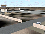
Green Island airport (RCGI) is one of the island airports in the eastern Taiwan. Lyudao island rises from the Pacific Ocean with 16.2 square-km area just 18NM east of Taitung. Equipped with a three thousand foot runway, Green Island (Lyudao) airport plays a key role in communicating with Taiwan. Daily flights between Taitung (RCFN) and Green Island makes it easy to access this oceanic playground. With Gmax technology, this package provides small but high quality Lyudao airport. Hope you enjoy it! Require El Formosa Part1.
| Filename: | El_Formosa__Taiwan_Scenery_Project_Part_7.zip |
| License: | Freeware, limited distribution |
| Added: | 3rd March 2006, 22:37:30 |
| Downloads: | 14,660 |
| Author: | Rudolf Liu, Kenny Chen |
| Size: | 1.39 MB |
| Category: Flight Simulator 2004 - Scenery | |
| VAKE Kandla/Gandhidham, India |
|
Images related to this file:
File Description:
Googly scenery for VAKE Kandla/Gandhidham - a small domestic airport
in the state of Gujurat, India, for which little other than a runway is
provided in Flight Simulator 2004. These scenery files add taxiways, aprons,
buildings and other airport features, so that you and your "AI" traffic can
land, taxi, park and take off in a realistic manner.
Gandhidham is a small city about 5 miles from the seaport of Kandla, in the
Gulf of Kutch, and was developed in 1950 after the separation of Pakistan and
India left the key port of Karachi in Pakistan. The airport is served by daily
flights using turboprop aircraft of Air Deccan.
The scenery does not purport to be ultra-accurate. Based on high-detail satellite
imagery from Google Earth, the layout is proportionally correct but the added
airport features, such as buildings, are built from default Microsoft objects
and add-on libraries so will not look exactly like the real thing.
You are not obliged to download and install any additional scenery libraries,
but to enjoy this scenery in its entirety, you may wish to. It will work fine,
with or without.
[File re-uploaded at request of AVSIM]
| Filename: | VAKE_KandlaGandhidham_India.zip |
| License: | Freeware |
| Added: | 14th May 2010, 05:11:31 |
| Downloads: | 848 |
| Author: | John Hinson |
| Size: | 67.36 KB |
| Category: Flight Simulator 2004 - Scenery | |
| FSE Scenery, W29, Bay Bridge |
|
File Description:
Scenery for W29, Bay Bridge, Kent, Maryland for use with FS2004 and Lagos new FLight Simulator Enhancer (FSE). I've made this far nicer than the place really is but I wanted a test bed to get reaquainted with the FSE interface and a place to try out some of the new features of FSE. It looked too nice to sit on the shelf tho so I thought I would share and make this number one in the PAMDVA series for FS2004. Here you'll find beautiful full seasonal sound which varies as you move about the airport. You'll also find 4 dynamic scenery tracks (two birds gliding overhead, a car that drives about the airport, and a cruising motorboat that plies the waves off the end of the runway. Some seasonal textures are used as well so that it looks correct in all 4 seasons. Many many details but EXTREMELY frame rate friendly. In fact, on my AMD 2600+ with 512 MB ram, and FX5900 I saw no loss at all. Lagos FSE for 2004 required. FSGenesis US Landclass highly recommended (freeware or payware versions.) Enjoy!
| Filename: | FSE_Scenery_W29_Bay_Bridge.zip |
| License: | Check within download |
| Added: | 28th December 2003, 18:35:43 |
| Downloads: | 1,650 |
| Author: | Lauren Robison |
| Size: | 784.39 KB |
| Category: Flight Simulator 2004 - Scenery | |
| CYCQ - Chetwynd - British Columbia, Canada |
|
Images related to this file:
File Description:
The town of Chetwynd (population around 2,600) is on the east side of the Rocky Mountains, the first town to be encountered when descending from the Rockies on highway 97. Previously known as Little Prairie, the town name was changed in 1962. The main occupations of the town are linked to forestry, fossil fuels, and transportation; there are railway lines north to Fort St John, east to Dawson Creek, and south to Prince George. The airport is on the southern side of the town, with one runway aligned 05-23, asphalted in 1975 and just under 4,500 feet long. There are no scheduled services, although a new terminal building was constructed in 2008, and the helicopter operations by at least two companies (oil and gas and medical evacuation flights) are the primary operations from the field. These are included in the AI, incorporating helicopter modifications made by Holger Sandmann so that they function properly as AI at an airfield. As an aside, landing like a plane and using the runway and taxiways is in fact exactly what a helicopter does at a normal airfield in real life; everyone does the same thing so that guessing is unneccesary.
| Filename: | CYCQ__Chetwynd__British_Columbia_Canada.zip |
| License: | Freeware, limited distribution |
| Added: | 28th March 2016, 21:36:33 |
| Downloads: | 298 |
| Author: | Roger Wensley |
| Size: | 18.84 MB |
| Category: Flight Simulator 2004 - Scenery | |
| Hope Field near Ottawa Ontario, Canada |
|
Images related to this file:
File Description:
The field is newly included in the Canada Flight Supplement. Unusually for a grass field the runway has the numbers marked out in white; given that this is a private airfield that does not invite unexpected guests and has only one plane based there, and presuming that the owner can remember his own runway headings, it is unlikely that these will still be there in a year's time. There is no hangar as yet. To the west is highway 416 and to the east is the Rideau River, both of which run north-south. Lke Rockcliffe (which is to the north) the airfield is right on the edge of the Ottawa control zone, so you should already be below 1,500 feet ASL when approaching from the south and talking to Ottawa tower when arriving from the north. The runway is 07/25 and 2,800 feet long, which should be enough for almost anybody, and the field is at 315 feet ASL. Manotick is a mile to the north east on the Rideau River and the Rideau Valley Airpark CPL3 is six miles south in the bend of the Rideau where it turns west.
| Filename: | Hope_Field_near_Ottawa_Ontario_Canada.zip |
| License: | Freeware, limited distribution |
| Added: | 10th July 2010, 19:34:51 |
| Downloads: | 200 |
| Author: | Roger Wensley |
| Size: | 3.15 MB |
| Category: Flight Simulator 2004 - Scenery | |
| Hewanorra TLPL on Saint Lucia in the eastern Caribbean |
|
Images related to this file:
File Description:
St Lucia island is to the north of the Grenadines, between Martinique and Saint Vincent. St Lucia is nearly 30 miles long and has a population of 175,000, with two airports. Hewanorra International is at the southern end of the island, the end furthest from the capital, Castries. The reason for this is that at the southern end it was possible to build a runway almost 9,000 feet long, while the airport in the north (Vigie) could not be extended further to accomodate the largest jets. The airport was originally a USAAF base, converted to commercial use.
All buildings are made with photographic textures and include the new terminal and a new control tower. The apron has been extended so that 747's etc can be accommodated, and there are regular international flights by Virgin, BA, Air Canada, Air France, etc and local connecting flights by LIAT; the AI includes both major international airlines and LIAT. The towns around the airport (Vieux Fort etc) are included here: the scenery is based on the "Lesser Antilles Mesh" which is required and can be downloaded for free.
| Filename: | Hewanorra_TLPL_on_Saint_Lucia_in_the_eastern_Carib.zip |
| License: | Freeware, limited distribution |
| Added: | 11th June 2013, 16:23:49 |
| Downloads: | 831 |
| Author: | Roger Wensley |
| Size: | 4.25 MB |
| Category: Flight Simulator 2004 - Scenery | |
| Golden Hawaii |
|
File Description:
This package will take you back to prewar Hawaii when it was a peaceful tropical paradise where the rich played and lucky military personnel enjoyed their island duty! After coming over on the PanAm Clippers, Inter-Island airways of Hawaii mainly handled air transportation for the wealthy vacationers. Included in this package are a Sikorsky S43 amphibian in Inter-Island colors, an S43 in PanAm colors, two Kellet autogyros and three Ford panel trucks to explore the local scenery! Also included is complete replacement scenery that portrays the islands as they did in the mid to late 1930s! This scenery is activated by a special program that allows you to choose between flying in either modern or golden age Hawaii. You can play the role of Air Line Captain with your own flight crew to fly the various scheduled and special flights for Inter-Island Airways or you can be the star flying reporter for a Honolulu newspaper with your Kellet Autogyro! There are 19 exciting and challenging flights to get you started and you'll have hours of fun in your new golden age flying career! By Lynn and Bill Lyons
| Filename: | Golden_Hawaii.zip |
| License: | Freeware |
| Added: | 18th August 2005, 22:07:23 |
| Downloads: | 12,511 |
| Author: | Lynn and Bill Lyons |
| Size: | 13.53 MB |
| Category: Flight Simulator 2004 - Scenery | |
| Deline CYWJ - Northwest Territories, Canada |
|
Images related to this file:
File Description:
This is the third in a series of airfields that follow in a southward direction that early access route to the Canadian northern shore, the Mackenzie River. Deline is south of Tuktuk, Inuvik, Fort McPherson, and Fort Good Hope, all already posted. Deline is at 704 feet asl and around 50 miles east of the the Mackenzie, where the Great Bear River flows out of the western end of Great Bear Lake on its way to the Mackenzie. This lake is huge. The town of Deline has a population of around 500, and the first trading post (of the North West Company) was established there as early as 1799. The Hudson Bay Company opened an outpost in 1825 to support the Franklin Arctic Exploration expedition, and it was then called Fort Franklin. The name was changed to Deline in 1993. The airport is just over a mile north of the town, and has almost 4,000 feet of gravel runway. There is no fuel available. The original airfield is still visible just to the north of the town, from before it was rebuilt on higher ground (better drainage) and away from the houses. AI will follow with later posts.
| Filename: | Deline_CYWJ__Northwest_Territories_Canada.zip |
| License: | Freeware, limited distribution |
| Added: | 5th July 2014, 14:47:36 |
| Downloads: | 240 |
| Author: | Roger Wensley |
| Size: | 2.54 MB |
| Category: Flight Simulator 2004 - Scenery | |
| Chilko Lake CAG3 & Scum Lake CAW3 in British Columbia Canada |
|
Images related to this file:
File Description:
Chilko Lake and Scum Lake are both on the eastern side of the Coast Mountains of British Columbia. Chilko Lake CAG3 is around 30 miles south of Puntzi Mountain and at the northern end of the lake, serving Tsylos Park Lodge, which caters for trekking, horse riding, mountain biking, fishing etc. The runway is 3,200 feet of gravel aligned 18-36 and unlit, at 3,850 feet ASL (above sea level). Scum Lake is around 30 miles southeast of Puntzi Mountain and 25 miles northeast of Chilko Lake. Don't ask me about the name. The airstrip appears to serve a small village and is noted as "private", so perhaps also a lodge operation. The runway is 3,500 feet of gravel aligned 03-21, unlit and at 3,921 feet ASL. I have posted these as a separate scenery, but I suggest that you just add it to your previously created "BC airfields" and avoid the inevitable doubling up of common textures etc. Plus that way you will have just one FS9 library post to do and new airfields will not need yet another posting. Up to you. If you find a defect, email me.
| Filename: | Chilko_Lake_CAG3__Scum_Lake_CAW3_in_British_Columb.zip |
| License: | Freeware, limited distribution |
| Added: | 21st November 2020, 18:24:29 |
| Downloads: | 114 |
| Author: | Roger Wensley |
| Size: | 11.85 MB |
| Category: Flight Simulator 2004 - Scenery | |
| Durban Island CWFB FOX-E DEW line station in Nunavut, Canada |
|
Images related to this file:
File Description:
Durban Island is 40 miles north of Cape Dyer on the southeast corner of Baffin Island, and around 60 miles southeast of Qikiqtarjuaq (known as Broughton until recently). Sitting on the top of the island is FOX-E, an intermediate station that was part of the DEW line. There is no runway (and once you have seen the island you will know why) and the station and its (usually) five man crew were supported by helicopter flights from Cape Dyer. The main feature is a 300' high mast, topped by comms gear to link both to Broughton to the north and Cape Dyer to the south. There was only one really habitable building, 80' x 30' in round figures, and this contained the generators, technical spaces, sleeping areas, kitchen, mess, and showers etc. There were also what were known as Anderson shelters, originally put up to house the construction crew and used in the summer for any maintenance people who visited for short periods. There was also a garage for a snow cat and tanks for fuel. And a view.
This post also includes new bgls for Cape Dyer to provide the 300' tower there too.
| Filename: | Durban_Island_CWFB_FOXE_DEW_line_station_in_Nunavu.zip |
| License: | Freeware, limited distribution |
| Added: | 1st July 2011, 22:11:33 |
| Downloads: | 313 |
| Author: | Roger Wensley |
| Size: | 1.87 MB |
© 2001-2026 AVSIM Online
All Rights Reserved
Privacy Policy |