
Where Flight Simulation Enthusiasts Gather from Around the World!
AVSIM Library - Search Results

| Category: Flight Simulator 2004 - Scenery | |
| Airstrips of Italy |

|
File Description:
Herewith about 40 small airfields from around Italy, some of which were not included in FS2004, each enhanced with taxiways, aprons, parking and buildings etc., both to enable the implementation of lightweight GA AI traffic in the area and to add a little generic detail.Again, there's no photo-realism here, just a selection of basic 'generic' buildings, more or less accurately sized and placed to reflect the airfield layout as seen on on-line satellite imagery and aerial photography. These buildings have minimal effect on frame-rates, so are ideal for this kind of job. The airfields are aligned as well as possible with the roads etc. in UT Europe and the Genesis Europe mesh, but should mostly be fine in a default installation or other configuration.
| Filename: | Airstrips_of_Italy.zip |
| License: | Freeware |
| Added: | 21st July 2025, 11:51:49 |
| Downloads: | 111 |
| Author: | Chris Eve |
| Size: | 299.94 KB |
| Category: Flight Simulator 2004 - Scenery | |
| AirFolies Casorezzo airfield, Italy - Revision 1 for VFR flights |
|
Images related to this file:
File Description:

Complete revision of previous "Casorezzo" scenery, realized on the real coordinates of the airfield including some buildings to real image. This review includes photo-realistic terrain multi-seasons/night. It requires the use of the "dva51" libraries and the "TreePlanter" system for vegetation; it is also realized with West Europe Elevation Meshes by Daniele Lanfranchi. Information: It represents the airfield "Air Folies" for ultralight of Casorezzo (MI), for trikes and other ultralights. Scenery contains a terrain 7x8 km, from Olcella (NW) to Parabiago west (NE), from Marcallo con Casone (SW) to Vittuone west (SE).
The airfield is located at 20 km NWW Milan, in the municipality of Casorezzo (N45.533199, E8.900685); grass runway of 280 m; Code: MICA. Enjoy!
Presentation video available here: http://youtu.be/8CfXr_hVWPU
| Filename: | AirFolies_Casorezzo_airfield_Italy__Revision_1_for.zip |
| License: | Freeware |
| Added: | 10th March 2015, 17:18:56 |
| Downloads: | 307 |
| Author: | Aldo Della Vedova - Daniele Lanfranchi |
| Size: | 76.45 MB |
| Category: Flight Simulator 2004 - Scenery | |
| Marsa Alam Int. Airport (Iata: RMF, Icao: HEMA) |
|
Images related to this file:
File Description:
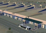
This FS2004 project reproduce the egyptian "Marsa Alam International Airport" (Iata: RMF, Icao: HEMA) located on the Red Sea coast. If you are a holiday-flights pilot, this airport is a “must have†!
In the scenery you'll find all buildings (airport, close surroundings and Port Ghalib resorts), hundred of custom made detailed objects, static and animated vehicles and a photoreal airport background. Each scenery part and object (frame-rate friendly thanks to the low poly design) has photoreal textures and everything is placed in the right position (which has been seen on summer 2016 at the real airport).English extended handbook is included. Watch the screenshot and the demo video on the Albysim youtube channel and enjoy all scenery features (in this free/demo edition some features are limited).
| Filename: | Marsa_Alam_Int_Airport_Iata_RMF_Icao_HEMA.zip |
| License: | Check within download |
| Added: | 29th October 2016, 21:26:52 |
| Downloads: | 1,010 |
| Author: | Albysim Scenery Design / Alberto Di Bolzano |
| Size: | 33.46 MB |
| Category: Flight Simulator 2004 - Scenery | |
| Homer PaHO in Alaska US |
|
Images related to this file:
File Description:
Homer is a mainly GA airfield with rows of open air parking, but it also has scheduled flights, a terminal building, a long (for GA) runway of just under 6,700 feet that is 150 feet wide and aligned 03-21 with VASI on both ends and ILS on 03. So I think we can refer to it as an airport. Plus, at the time of this scenery (around 2010) there were three newly completed hangars on the north apron that I was told were for three companies, Bald Mountain Air service, Maritime Helicopters, and Pathfinder Aviation. I do not know which was for whom, but all three companies are in the helicopter and/or plane charter business. The south apron has a number of hangars and other buildings along it's length, starting at the western end with Smokey Bay Air that has an old control tower on the roof, then the Fire Station, and then Homer Air. I am not aware of who owns what after those first three, except that at the far eastern end there are several garages etc for the airport maintenance equipment. Next to the airport at that end there are a number of boat maintenance companies with boats pulled out of the water; this could not be well replicated due to the airport elevation above the sea level and a misplaced road. The nearby Beluga Lake 5BL float base is also included here, with some AI. The lake height above sea level has been adjusted to cope with too many cliffs intruding into the water; this is an annoying FS9 habit. The Homer scenery is as close to the actual airport as I could make it, while coping with inaccurate coast lines and roads, and grassed areas that could not all be modified for reasons that I will not bore you with. The Spit is a major scenery feature next to the airport, and I have added to this to provide some boats, docks, and nearby buildings etc. Small planes use the adjacent gravel taxi path instead of the runway when back-tracking to take off on runway 21. They only go as far as the path takes them and then u-turn onto the runway and take off. By the way, this airport's AI will function at its best if the prevailing wind makes 03 the runway in use. And I will eventually stop writing 03 and just call it 3, as the US, alone in the world, does not put a zero in front of 01, 02, 03, 04 etc. Just one other thing to note is that all access to the runway is from taxiways A and B; there was (in 2010) no access to the extreme western end of the runway as the taxiway there is marked as out of service pending a needed resurfacing.
If you find an error email me please, and note that my email address has been changed to rogwens at Gmail dot com.
| Filename: | Homer_PaHO_in_Alaska_US.zip |
| License: | Freeware, limited distribution |
| Added: | 28th July 2021, 03:31:04 |
| Downloads: | 125 |
| Author: | Roger Wensley |
| Size: | 11.86 MB |
| Category: Flight Simulator 2004 - Scenery | |
| Lake Pontchartrain Bridge Replacement |
|
File Description:
Microsoft misplaced the Lake Pontchartrain Causeway Bridge on land north of the lake in the default scenery. This file will remove the misplaced bridge and place a double span bridge across the lake.
| Filename: | Lake_Pontchartrain_Bridge_Replacement.zip |
| License: | Freeware, limited distribution |
| Added: | 24th April 2008, 19:33:26 |
| Downloads: | 776 |
| Author: | Guy Maricich, Anthony Lynch |
| Size: | 25.32 KB |
| Category: Flight Simulator 2004 - Scenery | |
| Suisse 2004 Granges/Grenchen LSZG |
|
File Description:
Grenchen is a medium controlled airport North West of Switzerland, with one concrete runway and 3 grass runways. Updated file for FS2004, but works with FS2002. Good frame rate, but very detailled airport.
| Filename: | Suisse_2004_GrangesGrenchen_LSZG.zip |
| License: | Freeware, limited distribution |
| Added: | 5th October 2003, 16:59:51 |
| Downloads: | 10,842 |
| Author: | Daniel Gauthier |
| Size: | 6.87 MB |
| Category: Flight Simulator 2004 - Scenery | |
| EPWA - Warsaw Chopin Airport by Masterplan 2030 |
|
File Description:
EPWA / WAW / Warsaw Chopin Airport / Warsaw / Poland for the default FS9 / FS2004 by Masterplan 2030.
Included is a simple detailed Mainterminal + 2 new Satelites+ new Runway 15R/33L+ new Cargoramp + reworked Landclass-file.
| Filename: | EPWA__Warsaw_Chopin_Airport_by_Masterplan_2030.zip |
| License: | Freeware |
| Added: | 12th September 2013, 12:40:21 |
| Downloads: | 455 |
| Author: | Hendrik Klon, Endeavour AI |
| Size: | 1 MB |
| Category: Flight Simulator 2004 - Scenery | |
| Convair 440 Search and Rescue |
|
File Description:
SCENERIO;
This SAR involves a Convair 440. Red and white in color. 3 people on board.
The aircraft took off from juneau Intl(PAJN) direct for Teslin(CYZW). see readme for further details.
| Filename: | Convair_440_Search_and_Rescue.zip |
| License: | Freeware |
| Added: | 7th February 2004, 22:24:36 |
| Downloads: | 1,447 |
| Author: | Frank Betts |
| Size: | 141.48 KB |
| Category: Flight Simulator 2004 - Scenery | |
| JAWS |
|
File Description:
JAWS..Summer is near and so is JAWS..the killer shark..Take a patrol flight and see if you can find the Orca boat
being eaten alive off the coast of Martha's Vineyard..
| Filename: | JAWS.zip |
| License: | Freeware |
| Added: | 3rd April 2006, 03:17:53 |
| Downloads: | 915 |
| Author: | Ron Jeffers |
| Size: | 897.2 KB |
| Category: Flight Simulator 2004 - Scenery | |
| Scenery of Castle Irwell student housing in Salford, Greater Manchester, UK |
|
Images related to this file:
File Description:
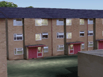
This scenery represents the "Castle Irwell" student housing belonging to Salford University, in the Salford, Greater Manchester area. Includes a fictional heliport (EGCI) to locate the scenery more easily. By Alan Pereira-Pierce.
| Filename: | Scenery_of_Castle_Irwell_student_housing_in_Salfor.zip |
| License: | Freeware |
| Added: | 7th March 2010, 21:15:07 |
| Downloads: | 254 |
| Author: | Alan Pereira-Pierce |
| Size: | 434.6 KB |
© 2001-2026 AVSIM Online
All Rights Reserved
Privacy Policy |