
Where Flight Simulation Enthusiasts Gather from Around the World!
AVSIM Library - Search Results

| Category: Flight Simulator 2004 - Scenery | |
| Thompson CYTH in northern Manitoba, Canada |

|
Images related to this file:
File Description:
Thompson is a city with around 13,000 inhabitants, located in northern Manitoba beside the Burntwood River. It serves as the administration centre for a large area of Manitoba and has industrial activities centred around mining and the processing of mined products. The version of the airport upon which this modification is based is the original posting in 2004 by CanUK Scenery. I would have made new buildings and a totally new scenery but I have the same problem as Sid and Pete in their later Thompson scenery: almost no photos!?! The update modifies the short end of the mainly gravel runway to asphalt (it was upgraded because it is regularly used as a taxiway) and also adds a later (2010?) gravel taxiway. The other ground modifications add allocated parking spots for fire fighting CL415 planes that are in the new AI, plus a lot more ga parking. You should already have some AI that includes Calm Air to see CYTH as it really is, the HQ of Calm Air. There are other additions including car parks and the usual sundry bits and pieces that inhabit every airfield. The CL415's with Manitoba textures are adaptations of what were originally Ontario planes and included with my post of Geraldton, not the most recent post in 2013, the one in 2007. If you don't have the planes get them from my Geraldton post. The AI version was made from the original piloted version which was by Massimo Taccoli. The AI helicopter was included in my post of Alma CYTF.
| Filename: | Thompson_CYTH_in_northern_Manitoba_Canada.zip |
| License: | Freeware, limited distribution |
| Added: | 23rd September 2018, 15:24:22 |
| Downloads: | 223 |
| Author: | Roger Wensley |
| Size: | 6.4 MB |
| Category: Flight Simulator 2004 - Scenery | |
| CYVQ - Norman Wells - Northwest Territories, Canada |
|
Images related to this file:
File Description:
Norman Wells is the last of a series of airfields that are along (or close to) the Mackenzie River and in the Northwest Territories. It is 290 miles southeast of Inuvik and just 40 miles northwest of Tulita. The town growth was accelerated by the discovery of oil in the 1930's and the building of a small refinery in 1937, which is included here; there are now around 840 folks living in the town. The airport is adjacent to the town and has just under 6,000 feet of asphalt runway. North Wright Airways is headquartered there and this is reflected in the AI, which is for all of the newly-posted Mackenzie River postings. There is also helicopter AI, Canadian North, First Air, and there are GA flights. There is a mandatory frequency and the Norman Wells tower is manned 24 hours a day so you will follow atc instructions. In real life the terminal is on two levels; this steep change in terrain level is not possible to achieve in FS9 so although I made it as a two level terminal (ready for the FSX version?) it is here modified into a single level building. There are several "taxiways" which lead to the runway but are without hold short markings. These have been shown but are not included as AI routes. The helicopters presumably hover-taxi to the runway across grass (and snow) in real life; the AI helicopter will taxi on wheels. Note that at mixed-use airports planes and helicopters all follow the same rules of procedure.
| Filename: | CYVQ__Norman_Wells__Northwest_Territories_Canada.zip |
| License: | Freeware, limited distribution |
| Added: | 12th July 2014, 11:22:10 |
| Downloads: | 472 |
| Author: | Roger Wensley |
| Size: | 14.57 MB |
| Category: Flight Simulator 2004 - Scenery | |
| CYYQ - Churchill Port & York Factory - Northern Manitoba, Canada |
|
Images related to this file:
File Description:
The main part of this scenery installs the Port of Churchill and the grain silos. Churchill CYYQ has been made by Sidney Schwartz, and this also adds AI and slightly modifies his parking to make a space big enough for Buffalo's C46. Churchill is in northern Manitoba, on the Churchill River where it empties into Hudson Bay. The town is accesible by air, by boat (once the winter ice melts) and most importantly by rail from the south. Grain from the Canadian prairies is hauled north and stored in Churchill for export to Europe by a sea route that is significantly shorter than any other, and there is a grain carrier included in the AI. Today there are perhaps 810 people living in Churchill, a slowly declining number. There are also a number of impressive polar bears. There was another port south of Churchill, but it was never completed, never connected to a railroad track, and never used. It was called Port Nelson, and was at the mouth of the Nelson River. Nearby, on the Hayes River, there is an old trading post called York Factory, built in 1684 and preserved as part of the living history of the north of Canada. The second scenery is for this, and for the nearby tourist camp called Silver Goose Lodge, which as the name suggests is for hunters. The large grassy area alongside the fort was for the trappers to camp on when they all arrived in early summer to trade the furs for goods.
| Filename: | CYYQ__Churchill_Port__York_Factory__Northern_Manit.zip |
| License: | Freeware, limited distribution |
| Added: | 23rd July 2014, 02:26:04 |
| Downloads: | 542 |
| Author: | Roger Wensley |
| Size: | 3.69 MB |
| Category: Flight Simulator 2004 - Scenery | |
| Lake Hood LHD and Z41 in Anchorage Alaska UPDATED |
|
Images related to this file:
File Description:
This is an updated version that is complete in itself and which greatly upgrades Lake Hood Airstrip Z41 and also makes minor modifications to LHD. Lake Hood is right next door and to the north of Ted Stevens Anchorage International Airport, and there is a second airfield on the north side of the lake called Lake Hood Airstrip. The airstrip is coded Z41, the International is PANC, and Lake Hood itself is LHD. You will need Ultimate Terrain Alaska Canada for this to work, and you should also download and install Anchorage International (verson 4?) by William Morgan of FRFStudio. LHD/Z41 includes a fair proportion of the 780 float planes that are based there and which make Lake Hood the largest and busiest float plane base in the world, averaging 190 flights per day during the year and a lot more than that per day during the summer months. There is fuel at two places on the lake, and a lot of maintenance help available. The documentation showing the VFR routes to Lake Hood is also included in the Lake Hood VFR procedures folder, and basically, if you listen to the ATC chatter, planes either route via the Ball Park or the Gravel Pit, which gets abbreviated to something like "You want the park or the gravel?" which wouldn't mean a whole lot to an unrehearsed stranger. Unfortunately FS doesn't reach that level of sophistication, but you can still take the right route. There is a google marked map showing the locations of the checkpoints.
| Filename: | Lake_Hood_LHD_and_Z41_in_Anchorage_Alaska_UPDATED.zip |
| License: | Freeware, limited distribution |
| Added: | 18th July 2010, 08:16:48 |
| Downloads: | 981 |
| Author: | Roger Wensley |
| Size: | 9.25 MB |
| Category: Flight Simulator 2004 - Scenery | |
| Zion National Park North, Cedar Breaks National Monument, Cedar City (KCDC), Utah, Photo-Scenery (FS9 & FSX) |
|
Images related to this file:
File Description:
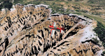
Cedar Breaks National Monument is a large amphitheater cliff in bright colors of red, orange and purple.
It lies east of Cedar City in the northern region of the scenery. The cliff was formed by erosion thru wind,
water and ice. Today erosion continues with a pace of about 2 inches every 5 years. Although it is called
Cedar Breaks, there are no cedars growing there but juniper trees. For a scenic flight to Cedar Breaks
National Monument best depart from Cedar City Regional Airport (KCDC) and head east. The scenery extends
south to Zion National Park and covers a large part of Zion Canyon and the Kolob Canyons area.
Zion National Park is another place where erosion of the Colorado Plateau formed the most beautiful colorful
stone formations of unique and wonderful shapes. There are nine different layers of stone visible in the park.
Most of them consist of sandstone. But there is also limestone, gypsum, siltstone, shale, clay and mudstone.
The Virgin River cut a spectacular and famous canyon thru Zion Park that is as narrow as 20ft and up to 2000ft tall.
High resolution versions of this scenery for FS9 and FSX (much sharper, but larger and multiple downloads)
are available at www.blueskyscenery.com/CNY_South2West5.html . The screenies are taken from the high-res versions,
so expect this version to be slightly more blurry.
Thanks to Joop Mak for providing a custom AFCADs that correct airport layouts so that they align with the photo-textures!
They are available here: www.blueskyscenery.com/AFCADs.html . YourDonation@Work: Dedicated to Richard, P.J. and Felix.
| Filename: | Zion_National_Park_North_Cedar_Breaks_National_Mon.zip |
| License: | Freeware, limited distribution |
| Added: | 14th March 2010, 00:30:28 |
| Downloads: | 1,564 |
| Author: | Gottfried Razek - blueskyscenery.com |
| Size: | 97.13 MB |
| Category: Flight Simulator 2004 - Scenery | |
| Quesnel CYQZ in British Columbia, Canada |
|
File Description:
Quesnel is around 65 miles south of Prince George, at the junction of the Fraser and Quesnel Rivers. It has a population of less than 10,000 and is reliant on the timber industry and tourism (hiking, canoeing, fishing, hunting) in the surrounding area for it's income. The date for this scenery is, once again, around 2010. The airport is on the northern edge of the town and has a runway of 5,500 feet aligned 13-31 with PAPI at both ends. Because of the surrounding terrain runway 13 has a right hand VFR circuit. Parking for GA aircraft is organised by the Quesnel Flying Club in a grassed area adjacent to the concrete and asphalt apron. Also adjacent to the apron is the extraordinary terminal building, and next to that is the comparatively very ordinary building that houses the flying club. There are the usual airfield and plane maintenance buildings, and at the southern end of the runway two private hangars. There is also a Fire Base housing personnel that either drive from the base or fly by helicopter to deal with local forest fires at ground level. The AI included here is for Central Mountain Air and GA. I added to and adjusted the CYXS AI so that there are GA flights between CYXS and CYQZ, so just replace your current CYXS AI with this new one. Please email me if you find faults, such as a plane without textures. Note my newish email address at the end of these notes.
| Filename: | Quesnel_CYQZ_in_British_Columbia_Canada.zip |
| License: | Freeware, limited distribution |
| Added: | 19th December 2022, 19:27:14 |
| Downloads: | 145 |
| Author: | Roger Wensley |
| Size: | 9.49 MB |
| Category: Flight Simulator 2004 - Scenery | |
| Belagondapalli, India - Hosur Aerodrome |
|
File Description:
VO95 is in Belagondapalli, India is for private military and maintenance services for SpiceJet and others for check up 737's. There are a few details in the scenery.
| Filename: | Belagondapalli_India__Hosur_Aerodrome.zip |
| License: | Freeware |
| Added: | 8th March 2019, 00:41:02 |
| Downloads: | 181 |
| Author: | Stuart John Gilbert II |
| Size: | 1.36 MB |
| Category: Flight Simulator 2004 - Scenery | |
| Tonopah Test Range |
|
Images related to this file:
File Description:

This scenery is offered as a gift to the Flight Sim community by Team SDB. The scenery is self-installing and includes accurate airbase arrangements and appropriate static aircraft.
| Filename: | Tonopah_Test_Range.zip |
| License: | Freeware, limited distribution |
| Added: | 9th April 2013, 21:01:40 |
| Downloads: | 448 |
| Author: | Team SDB |
| Size: | 2.27 MB |
| Category: Flight Simulator 2004 - Scenery | |
| Ice Station Alpha |
|
Images related to this file:
File Description:

This scenery is offered as a gift to the Flight Sim community by Team SDB. The scenery is self-installing and includes accurate airbase arrangements and appropriate static aircraft.
| Filename: | Ice_Station_Alpha.zip |
| License: | Freeware, limited distribution |
| Added: | 9th April 2013, 20:59:40 |
| Downloads: | 302 |
| Author: | Team SDB |
| Size: | 957.53 KB |
| Category: Flight Simulator 2004 - Scenery | |
| Stoelln , Germany - EDOR |
|
File Description:
There is an Interflug IL-62 parked as a museum. Lady Agnes IL62 landed on grass back in 1989. The airstrip has gliders and private planes still there today.
| Filename: | Stoelln__Germany__EDOR.zip |
| License: | Freeware |
| Added: | 6th July 2018, 02:50:56 |
| Downloads: | 107 |
| Author: | Stuart John Gilbert II |
| Size: | 2.84 MB |
© 2001-2026 AVSIM Online
All Rights Reserved
Privacy Policy |