
Where Flight Simulation Enthusiasts Gather from Around the World!
AVSIM Library - Search Results

| Category: Flight Simulator 2004 - Scenery | |
| Brescia Montichiari (LIPO) AI Traffic Patch |

|
File Description:
This patch, for FS2004 only, fixes the problem of AI Traffic in LIPO 2003 scenery. a new AFCAD2 file is included
| Filename: | Brescia_Montichiari_LIPO_AI_Traffic_Patch.zip |
| License: | Freeware, limited distribution |
| Added: | 4th February 2004, 04:15:10 |
| Downloads: | 20,146 |
| Author: | ISD Project |
| Size: | 144.56 KB |
| Category: Flight Simulator 2004 - Scenery | |
| VNTR - Tumlingtar Airport - Tumlingtar, Nepal |
|
File Description:
Tumlingtar Airport (IATA: TMI, ICAO: VNTR), also known as Tumling Tar Airport, is an airport serving Tumlingtar, a city in Nepal.
| Filename: | VNTR__Tumlingtar_Airport__Tumlingtar_Nepal.zip |
| License: | Freeware |
| Added: | 3rd November 2014, 06:57:32 |
| Downloads: | 397 |
| Author: | Billy Guo |
| Size: | 308.9 KB |
| Category: Flight Simulator 2004 - Scenery | |
| Linzhi 2008 v2.0 (ZUNZ) |
|
File Description:
One of Chinese high-altitude aerodromes. Working with RNP now. It's still a big challenge by VFR. ICAO / IATA: ZUNZ / LZY
| Filename: | Linzhi_2008_v20_ZUNZ.zip |
| License: | Freeware, limited distribution |
| Added: | 30th April 2009, 09:07:54 |
| Downloads: | 1,684 |
| Author: | Billy Guo |
| Size: | 14.71 MB |
| Category: Flight Simulator 2004 - Scenery | |
| ZLGY - Guyuan Liupanshan Airport - Guyuan, China |
|
File Description:
There is no stock in FS2004. Juneyao and Joy Air serve the airport today. There are quite a few details improved.
| Filename: | ZLGY__Guyuan_Liupanshan_Airport__Guyuan_China.zip |
| License: | Freeware |
| Added: | 30th August 2015, 02:44:30 |
| Downloads: | 298 |
| Author: | Stuart J Gilbert II |
| Size: | 1.39 MB |
| Category: Flight Simulator 2004 - Scenery | |
| Africa Scenery Fix 2 |
|
File Description:
This is a fix for the default Africa scenery in MSFS 2004. It raises Ishasha airport in SE Zaire by 1000m.
| Filename: | Africa_Scenery_Fix_2.zip |
| License: | Freeware |
| Added: | 15th April 2004, 15:38:12 |
| Downloads: | 3,361 |
| Author: | Jim Keir |
| Size: | 1.98 KB |
| Category: Flight Simulator 2004 - Scenery | |
| MESH 2010 SurAmerica - Colombia 1 |
|
File Description:
MESH FERMANDOIS 2010 V1.0 / Colombia Norte / index(CO1,CO2) / A highly detailed 30m SRTM mesh for South America (FS2004 and FSX)
| Filename: | MESH_2010_SurAmerica__Colombia_1.zip |
| License: | Freeware |
| Added: | 3rd December 2009, 09:09:32 |
| Downloads: | 3,357 |
| Author: | Jose Fermandois |
| Size: | 62.34 MB |
| Category: Flight Simulator 2004 - Scenery | |
| Comoros Airport Package Fix |
|
File Description:
This is a fix for my comoros airport package scenery, it corrects lights issues on FMCH. see readme for more info
| Filename: | Comoros_Airport_Package_Fix.zip |
| License: | Freeware |
| Added: | 12th April 2021, 23:44:29 |
| Downloads: | 171 |
| Author: | EMMANUEL MWANDOSYA |
| Size: | 7.78 MB |
| Category: Flight Simulator 2004 - Scenery | |
| Fort St James CYJM in British Columbia Canada |
|
Images related to this file:
File Description:
Fort St James is a small town of around 1,600 folks at the southeastern end of Stuart Lake, at the head of the Stuart River, and around 360 miles north of Vancouver and 220 miles inland from the coast. It was a long-established trading post for furs, with a permanent presence there from 1806 onwards. The airfield is 3 miles south of the town and is called "Fort St James (Perison)" in the Nav Canada listings. I presume that this is part of their trend towards calling airfields by their location rather than by their name. Makes sense as it is difficult to find information by searching for an airfield that is listed under a name you don't know. The field has an asphalt runway of 4,000 feet aligned 10-28 and at 2,364 feet ASL. There is no lighting. The main user of the airfield is Interior Helicopters Ltd. who are based there as operators, and at Williams Lake as helicopter dealers. For the AI helicopters, there is a screenshot (01) of the AS350 helicopter installation folder when it has been transformed into an AI helicopter. The process is to download and install the Ecuriel AS 350, along with the additional textures, as normal; this is straightforward. Then you download the software shown in screenshot 02 and add it as instructed and as shown in 01 so that the helicopter now operates as AI, with a different air file and a modified config file. I should have included this with the Pemberton post. I have posted this as Fort St James CYJM, but I suggest that you just add it to your previously created "BC airfields" and avoid the inevitable doubling up of common textures etc. Up to you. If you find a defect, email me.
| Filename: | Fort_St_James_CYJM_in_British_Columbia_Canada.zip |
| License: | Freeware, limited distribution |
| Added: | 23rd November 2020, 20:14:04 |
| Downloads: | 150 |
| Author: | Roger Wensley |
| Size: | 2.62 MB |
| Category: Flight Simulator 2004 - Scenery | |
| Bryce Canyon National Park (KBCE), Utah, Photo-Scenery |
|
Images related to this file:
File Description:
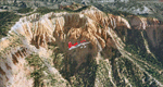
Bryce Canyon National Park (KBCE), Utah, Photo-Scenery (FS9 & FSX)
Despite its name, Bryce Canyon is not actually a canyon that was formed by a river, but rather a giant natural cliff shaped through erosion by wind, water, and ice. Bryce is distinctive due to its geological formations, delicate and colorful pinnacles called hoodoos that are up to 200ft high. The bizarre forms and red, orange and white colors of the rocks provide spectacular views. Unfortunately the hoodoos are too small for the elevation mesh in flight simulator. But you can enjoy the colors and shape of the cliffs. The cliffs in main region of the park, just south of the airport are partly covered
by snow. But on the southern and western part of the plateau you can enjoy them free of snow. Bryce Canyon is named after the Mormon pioneer Ebenezer Bryce who settled in this area in the 1850s. It was designated as a national park in 1928.
Bryce Canyon Airport (KBCE) just handles small aircraft on a daily basis. But is was actually built to handle larger aircraft in case of emergency. And so on Oct.6th 2000 an American Airlines MD-82 from Denver to Los Angeles made a successful emergency landing after reporting smoke in the cockpit and a loss of cabin pressure.
High resolution versions of this scenery for FS9 and FSX (much sharper, but larger and multiple downloads)are available at www.blueskyscenery.com/CNY_South2West4.html . The screenies are taken from the high-res versions, so expect this version to be slightly more blurry. Thanks to Joop Mak for providing a custom AFCADs that correct airport layouts so that they align with the photo-textures! They are available here: www.blueskyscenery.com/AFCADs.html . YourDonation@Work: Dedicated to Michael, Pat and Keith.
| Filename: | Bryce_Canyon_National_Park_KBCE_Utah_PhotoScenery.zip |
| License: | Freeware, limited distribution |
| Added: | 7th March 2010, 11:17:56 |
| Downloads: | 2,204 |
| Author: | Gottfried Razek, blueskyscenery.com |
| Size: | 96.35 MB |
| Category: Flight Simulator 2004 - Scenery | |
| Airstrips of North-West Europe |
|
Images related to this file:
File Description:
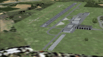
The sales blurb for FS2004 announced the inclusion of over 23,000 airfields ... unfortunately a significant number of those consisted of little or nothing more than a runway on a flatten with a rectangular background polygon.
To enable the addition of an amount of lightweight GA AI traffic, without overloading those airfields that were designed with parking spaces and taxi-ways, (and are probably already busy), I herewith include over 140 small sceneries, of mostly default airfields, from NW France, up the English Channel and the North Sea coast through Belgium, the Netherlands and NW Germany to Denmark, all with added taxiways and parking spots, aprons, generic buildings and background polygons as appropriate, to enable AI traffic to be generated without interrupting things at the more major airports.
A few of the French airfields are "new", not included originally with FS2004, and a couple have been updated to suit more recent developments :- for example, LFES "Scaer Guiscriff" is now LFES "Bretagne Atlantique", LFOR "Chartres Champhol" is now LFOR "Chartres Metropole", EHSE "Seppe" is now EHSE "Breda International" and EKVH "Vesthimmerlands" was previously EKVH "Aars".
There's no photo-realism here, just a selection of basic 'generic' buildings, more or less accurately sized and placed to reflect the airfield layout as seen on on-line satellite imagery and aerial photography. These buildings have minimal effect on frame-rates, so are ideal for this kind of job.
The airfields are aligned as well as possible with the roads etc. in UT Europe and the Genesis Europe mesh, but should mostly be fine in a default installation or other configuration.
Please read the rest of this "waffle" in the included text file ... it might save some confusion ;)
Enjoy :)
| Filename: | Airstrips_of_NorthWest_Europe.zip |
| License: | Freeware |
| Added: | 14th June 2024, 13:44:58 |
| Downloads: | 283 |
| Author: | Chris Eve |
| Size: | 9.95 MB |
© 2001-2026 AVSIM Online
All Rights Reserved
Privacy Policy |