
Where Flight Simulation Enthusiasts Gather from Around the World!
AVSIM Library - Search Results

| Category: Flight Simulator 2004 - Scenery | |
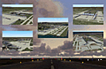
| Inyokern Airport, Inyokern CA. , USA - Version 3 |

|
Images related to this file:
File Description:

FS2004 Scenery for Inyokern Airport (KIYK). SORRY everyone there were some libraries and textures missing from the recent release. This package contains all missing objects and libraries and is a complete replacement for ANY of my Inyokern sceneries previously installed, no other download required. (Nestled on the sunny side of the southern Sierras, Inyokern is a great jumping-off place for hi desert adventures. Known for decades for it's great soaring spots, Inyokern itself is busy enough with an average of 80 flights a day including it's United/Skywest commuter flights and occasional military traffic from the nearby China Lake Naval Weapons Test Center. Geographically, the airport is situated in the high desert of Southern California, 100 miles east-northeast of the county seat in Bakersfield, 80 miles north-northeast of the Lancaster and Palmdale areas, and 120 miles north-northwest of San Bernardino. The airport itself covers 1,640 acres at an elevation of 2,457 feet, with three asphalt paved runways that can accommodate almost any class of civilian, commercial, or military aircraft. Inyokern Airport is served by commercial airlines connecting through Los Angeles International Airport.)
| Filename: | Inyokern_Airport_Inyokern_CA__USA__Version_3.zip |
| License: | Freeware, limited distribution |
| Added: | 10th November 2013, 23:32:02 |
| Downloads: | 2,055 |
| Author: | John Stinstrom |
| Size: | 6.36 MB |
| Category: Flight Simulator 2004 - Scenery | |
| Jetways & Terminals For ACOF Package Final |
|
Images related to this file:
File Description:
The Final Package of the "Jetways & Terminals" program with all 38 updated and improved sceneries: EDDH Hamburg Fuhlsbuettel, EDDM Munich Muenchen Franz Josef Strauss, FACT Cape Town D.F.Malan, HKJK Nairobi Jomo Kenyatta, KLAS Las Vegas McCarran, KLAX Los Angeles, KLGA New York La Guardia, KOAK Oakland Metro, KSAN San Diego Lindbergh, KSFO San Francisco, KSNA Santa Ana John Wayne Orange County, NZAA Auckland, RCTP Taipei Taiwan Taoyuan, RJAA Tokyo Narita, RKSI Seoul Incheon, RPLL Manila Ninoy Aquino, SBGL Rio De Janeiro Galeão, SCEL Santiago De Chile Arturo Merino Benitez, SKBO Bogotá El Dorado, SLLP La Paz El Alto, VHHH Hongkong Chek Lap Kok, VIDP Delhi Indira Gandhi, VMMC Macau Airport, VOBL Bangalore Bengaluru, VOHS Hyderabad Rajiv Gandhi, VTBS Bangkok Suvarnabhumi, WMKK Kuala Lumpur Sepang, WMKP Penang Bayan Lepas, WSSS Singapore Changi, YBBN Brisbane, YMML Melbourne Tullamarine, YSSY Sydney Kingsford Smith, ZBAA Beijing Capital, ZGGG Guangzhou New Baiyun, ZGKL Guilin Liangjiang, ZGSD Zhuhai Sanzao, ZGSZ Shenzhen Huangtian, ZSPD Shanghai Pudong. All AFCAD files included. Landclass files and XML ILS-Approaches included. Please visit the forum threads and read the online Installation Guide in english and german language (see read me file fs2004-jetways-terminals-final.txt for links).
| Filename: | Jetways__Terminals_For_ACOF_Package_Final.zip |
| License: | Freeware |
| Added: | 26th November 2008, 11:45:05 |
| Downloads: | 48,996 |
| Author: | Jan Martin |
| Size: | 2.99 MB |
| Category: Flight Simulator 2004 - Scenery | |
| KCMH - Port Columbus International - Columbus, Ohio, USA |
|
Images related to this file:
File Description:
Port Columbus International Airport in Columbus, Ohio, is a gem of an airport for aviation buffs. It first opened in 1929 at a site chosen by Chales Lindbergh, as part of an air-rail route from New York to Los Angeles. The original terminal building has been restored and is now used for office space. Two of the original three hangers are still in use (I included the third hanger in the scenery). The six hanger Lane Aviation FBO was added in 1935 and has been in operation these 78 years. In 1959 the modern terminal was first built, with additions and renovations to follow. Netjets opened their facilities in 2001. With the exception of the runways, this version of KCMH was built entirely from scratch. This is the first large airport I've done in which all buildings on the field (except for the control tower) are custom made and partly or fully photo textured. I've also made more use of ground photo textures. Many hours went into the creation of Port Columbus International Airport for FS9. I hope you enjoy it. My thanks to Wil Morgan of FRAME-RATE-FRIENDLY Studio (WWW.FRFSTUDIO.NET) for the AI aircraft parking assignments and general testing. The vintage TWA textures for the DC3's are by Dale De Luca.
| Filename: | KCMH__Port_Columbus_International__Columbus_Ohio_U.zip |
| License: | Freeware |
| Added: | 11th June 2013, 22:51:45 |
| Downloads: | 2,802 |
| Author: | Sidney Schwartz |
| Size: | 17.74 MB |
| Category: Flight Simulator 2004 - Scenery | |
| Bryce Canyon National Park (KBCE), Utah, Photo-Scenery |
|
Images related to this file:
File Description:
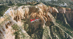
Bryce Canyon National Park (KBCE), Utah, Photo-Scenery (FS9 & FSX)
Despite its name, Bryce Canyon is not actually a canyon that was formed by a river, but rather a giant natural cliff shaped through erosion by wind, water, and ice. Bryce is distinctive due to its geological formations, delicate and colorful pinnacles called hoodoos that are up to 200ft high. The bizarre forms and red, orange and white colors of the rocks provide spectacular views. Unfortunately the hoodoos are too small for the elevation mesh in flight simulator. But you can enjoy the colors and shape of the cliffs. The cliffs in main region of the park, just south of the airport are partly covered
by snow. But on the southern and western part of the plateau you can enjoy them free of snow. Bryce Canyon is named after the Mormon pioneer Ebenezer Bryce who settled in this area in the 1850s. It was designated as a national park in 1928.
Bryce Canyon Airport (KBCE) just handles small aircraft on a daily basis. But is was actually built to handle larger aircraft in case of emergency. And so on Oct.6th 2000 an American Airlines MD-82 from Denver to Los Angeles made a successful emergency landing after reporting smoke in the cockpit and a loss of cabin pressure.
High resolution versions of this scenery for FS9 and FSX (much sharper, but larger and multiple downloads)are available at www.blueskyscenery.com/CNY_South2West4.html . The screenies are taken from the high-res versions, so expect this version to be slightly more blurry. Thanks to Joop Mak for providing a custom AFCADs that correct airport layouts so that they align with the photo-textures! They are available here: www.blueskyscenery.com/AFCADs.html . YourDonation@Work: Dedicated to Michael, Pat and Keith.
| Filename: | Bryce_Canyon_National_Park_KBCE_Utah_PhotoScenery.zip |
| License: | Freeware, limited distribution |
| Added: | 7th March 2010, 11:17:56 |
| Downloads: | 2,204 |
| Author: | Gottfried Razek, blueskyscenery.com |
| Size: | 96.35 MB |
| Category: Flight Simulator 2004 - Scenery | |
| Spain IFR Update / Actualización IFR de España (AIRAC-AMDT 04/06) |
|
File Description:
This update will install in FS2004 the latest navaids in service in Spain (AIRAC-AMDT 04/06), and others that have been omitted in the original program. At the same time, install corrections to some navaids that have tuning or range problems. This pack contains installation and instructions files in English and Spanish. // Esta actualización instalará en FS2004 las últimas radioayudas que han entrado en servicio en España (AIRAC-AMDT 04/06), y otras que han sido omitidas en el programa original. Al mismo tiempo instala correcciones a algunas radioayudas que tienen problemas de sintonización o de cobertura. Este pack contiene los archivos de instalación e instrucciones en español e inglés.
| Filename: | Spain_IFR_Update__Actualizacin_IFR_de_Espaa_AIRACA.zip |
| License: | Freeware |
| Added: | 11th May 2006, 14:48:18 |
| Downloads: | 5,165 |
| Author: | Rafael Povedano |
| Size: | 1.35 MB |
| Category: Flight Simulator 2004 - Scenery | |
| WAHR - Heathers Ranch |
|
File Description:
The other upload had checksum errors.
Heathers Ranch is located about 5 miles west of Port Angeles, Wa. Heather has made a lot of Virtual money from the BFU gang and others painting and re-furbishing their aircraft. This scenery was created for her because of her caring and unselfish attitude as well as her talents.
There are 2 runways, 18-36 is an oilsoaked dirt runway with oilsoaked taxiways. If you need your oil changed, Heather or her brother will change it free for the used oil. The other runway is a water runway and is in the sound adjacent to the ranch. There is a pier there that has fuel. For more service, climb the bank and taxi up to the hanger. “Easily accessed by air (STOL only), boat or road.”
You will need Gerrish Gray’s Trees_v3.zip installed. There are FSE file included but are not necessary for the enjoyment of this scenery.
| Filename: | WAHR__Heathers_Ranch.zip |
| License: | Freeware, limited distribution |
| Added: | 3rd July 2004, 19:53:57 |
| Downloads: | 3,279 |
| Author: | Joe Watson |
| Size: | 3.59 MB |
| Category: Flight Simulator 2004 - Scenery | |
| Santiago Cibao Int'l Airport |
|
File Description:
This is the scenery of Dominican Republic's second biggest city. Cibao Intl Airport MDST
was inagurated in 2002 and since then it has been the bridge for thousands of people that fly
to and from this beautiful city located in Dominican Republic. Our main goal from this
package is to give you the chance of knowing Santiago de los Caballeros (The first Santiago
of the western hemisphere) and enjoying it. This version is the only version which is freware
with many features (it is not a demo), it includes: Cibao Airport and all of its buildings fully detailed, Animated jetways, Marsharllers at each gate, landclass of the entire Cibao Region, and much more!!
| Filename: | Santiago_Cibao_Intl_Airport.zip |
| License: | Freeware |
| Added: | 24th June 2006, 15:42:21 |
| Downloads: | 8,422 |
| Author: | Dominican Aerodromes |
| Size: | 7.1 MB |
| Category: Flight Simulator 2004 - Scenery | |
| I Brigada Aérea "El Palomar" - SADP 2006 |
|
File Description:
EL PALOMAR es la primera brigada aérea de la Fuerza Aérea Argentina y en el operan como base los C-130, L-100-30, B707-320, DH6, Learjet 35 y 23, F-28, F27 y el avion presidencial TANGO 01 (B757-200). Ademas de utilizar programas de última generación y las más avanzadas técnicas de diseño, Nowhere Media Studio® introduce con este escenario, el primer sistema de iluminación de plataforma por medio de efectos.
EL PALOMAR is the first air brigade of the Argentine Air Force and in this airfield operate the C-130's, L-100-30's, B707-320's, DH6's, Learjet 35's and 23's, F28's, F27's of this airforce, and the presidential airplane TANGO 01 (B757-200). In adittion to using the last generation design programs and tecnics, Nowhere Media Studio® is proud to offer an scenery with a platform ilumination system operated by effects
| Filename: | I_Brigada_Area_El_Palomar__SADP_2006.zip |
| License: | Freeware, limited distribution |
| Added: | 28th February 2006, 04:35:21 |
| Downloads: | 3,531 |
| Author: | Nowhere Media Studio® - Juan M. Cortéz |
| Size: | 11.83 MB |
| Category: Flight Simulator 2004 - Scenery | |
| Havana 1962 Scenery |
|
File Description:
This scenery includes Havana as it was in 1962 (a mysterious city of much fascination for me) including El Morro Fortress on its rocky outcropping at the entrance to Havana harbor, the largest such fortress in the Caribbean, and its adjacent lighthouse. In downtown Havana you will see the capital building and several old cathedrals. Near the Malicon sea walk by the beach, you will find 3 famous hotels and former casinos, the Flamingo, the Riviera, and the Havana Hilton. The Havana Hilton opened just days before Castro seized power and nationalized it. When he first came to power he occupied the top floor for some time. Havana Airport opened originally as Rancho Los Boyeos Airport, located just southwest from the city in the village of the same name, which was then mostly farms, small ranches, and tiny communities. The original terminal was a very pretty Spanish colonial building, which the dictator Fulgencio Batista had remodeled in a 1950's cubist-tudor style. It was at the time of this remodeling (1957) that the airport's name was changed to Jose Marti International Airport, named after the famous Cuban revolutionary and poet of the 19th century. Jose Marti Airport was in the 1950s and 1960s the primary port of entry airport for Cuba. Up until the January 1st 1959 revolution many US airlines served Havana, but due to mounting tensions, the crisis of the Bay of Pigs attack, and later on the October 1962 missile crisis, traffic and tourism was ended as the US led blockade of Cuba took hold. By the time of this scenery, April 1962, the once former bustling Jose Marti airport had become quite sedate.
| Filename: | Havana_1962_Scenery.zip |
| License: | Freeware, limited distribution |
| Added: | 4th March 2010, 23:36:41 |
| Downloads: | 3,864 |
| Author: | Mike Stevens and Tom Gibson |
| Size: | 9.72 MB |
| Category: Flight Simulator 2004 - Scenery | |
| Ría de Vigo (Bay of Vigo) |
|
File Description:
Comprehensive revision of the area surroinding the Bay of Vigo, near the Vigo Airport (LEVX, aprox. at 42º18'N 8º38'W), in Galicia, Spain, including a more accurate coastline, from the Ría de Aldán until Toralla Island, plus the San Simon Island and other minor islands, detailed piers in Vigo and Cangas, several beaches, and a lot of 3D VFR references (more than 180 macros added), such as buildings (the City Hall, the Hospital Xeral, the Balaídos Stadium, the Castro stronghold...), working lighthouses, several monuments and statues, some main streets redrawn, a new version of my Rande Bridge, now with collision detection and landable surface, and a handfull of eye-candies I can't even remember! -
Completa revisión da costa da Ría de Vigo, dende a Ría de Aldán ata pasada a Illa de Toralla, incluíndo, por suposto, á Illa de San Simón e outros pequenos illotes, praias (Samil, Nerga...), os peiraos de Cangas e de Vigo, dende o Areal ata Bouzas, unha morea de novas referencias visuais (máis de 180 macros), con edificios (o Concello, o Hospital Xeral, o estadio de Balaídos, o castelo do Castro, o lazareto de San Simón...), faros (nas Cíes e na costa...), algún que outro monumento, unha revisión do trazado dalgunhas das vías principais, unha nova versión da miña Ponte de Rande, con detección de colisións e superficie "aterrable", e moitas cousas máis que xa nin eu mesmo lembro. -
Completa revisión de la costa de la Ría de Vigo (Galicia, España, aprox. en 42º18'N 8º38'O), desde la Ría de Aldán hasta pasada la Isla de Toralla, incluyendo la Isla de San Simón y otros pequeños islotes, playas (Samil, Nerga...), los muelles de Cangas y de Vigo, desde el Areal hasta Bouzas, un montón de nuevas referencias visuales (más de 180 macros), con edificios (el Ayuntamiento, el Hospital Xeral, el estadio de Balaídos, el castillo del Castro, el lazareto de San Simón...), faros (en las Cíes y en la costa...), algún que otro monumento, una revisión del trazado de algunas de las vías principales, una nueva versión de mi Puente de Rande, con detección de colisiones y superficie "aterrizable", y muchas cosas más de las que ni yo mismo me acuerdo.
| Filename: | Ra_de_Vigo_Bay_of_Vigo.zip |
| License: | Freeware |
| Added: | 16th May 2004, 23:48:38 |
| Downloads: | 4,478 |
| Author: | Rubén Castiñeiras |
| Size: | 366.85 KB |
© 2001-2026 AVSIM Online
All Rights Reserved
Privacy Policy |