
Where Flight Simulation Enthusiasts Gather from Around the World!
AVSIM Library - Search Results

| Category: Flight Simulator 2004 - AI Flight Plans | |
| Condor Flugdienst 1994 traffic (retro) |

|
Images related to this file:
File Description:

Condor Flugdienst GmbH, usually shortened to Condor, is an airline based in Germany, operating scheduled leisure flights to the Mediterranean, Asia, Africa, North America and the Caribbean as part of Thomas Cook Group. Its main base is Frankfurt Airport.
Flightplans based on the summer, 1994 Condor's timetable.
| Filename: | Condor_Flugdienst_1994_traffic_retro.zip |
| License: | Freeware |
| Added: | 31st May 2012, 17:06:30 |
| Downloads: | 497 |
| Author: | Oleg Tchernikov |
| Size: | 7.35 KB |
| Category: Flight Simulator 2004 - Scenery | |
| City of Birmingham, Alabama |
|
File Description:
City of Birmingham, Alabama State biggest city and located north from alabama state capitol city Montgomery. This add-on scenery adds four most famoust buildings into Birmingham downtown area: AmSouth-Sonat tower, Wachovia tower, Bellsouth and AmSouth-Harbert Plaza.
I hope you like this add-on.
| Filename: | City_of_Birmingham_Alabama.zip |
| License: | Freeware |
| Added: | 11th July 2004, 15:48:53 |
| Downloads: | 2,486 |
| Author: | Toni Hiltunen |
| Size: | 158.87 KB |
| Category: Flight Simulator 2004 - Scenery | |
| OryxSim Khasab / Northern Oman SRTM Mesh -FIX- |
|
Images related to this file:
File Description:

This fix removes the steep hill north of the airport when using the OryxSim Khasab scenery in combination with the Northern Oman SRTM mesh by Yohann Baptiste. This fix is not recommended for users using the default scenery. This file requires version 2.0 of OryxSim Khasab.
| Filename: | OryxSim_Khasab__Northern_Oman_SRTM_Mesh__FIX.zip |
| License: | Freeware |
| Added: | 15th February 2010, 10:47:45 |
| Downloads: | 1,648 |
| Author: | OryxSim |
| Size: | 1.42 KB |
| Category: Flight Simulator 2004 - Scenery | |
| New Zealand SRTM Elevation Mesh LOD9 |
|
File Description:
New Zealand elevation mesh scenery based on SRTM data, LOD9. Includes terrain only and combines with any default or add-on scenery, no *additional* landcover information, coastline definitions or airports. This single ZIP-file includes North and South island and nearby smaller islands (e.g. Chatham Is.).
| Filename: | New_Zealand_SRTM_Elevation_Mesh_LOD9.zip |
| License: | Freeware, limited distribution |
| Added: | 11th July 2004, 04:40:56 |
| Downloads: | 9,231 |
| Author: | Matthias Weidemann |
| Size: | 40.03 MB |
| Category: Flight Simulator 2004 - AI Flight Plans | |
| Icelandair - Winter2005 |
|
File Description:
Finally the winter 2005 flightplans of Icelandair. Icelandair is the icelandic aircompany that links Keflavik airport with the most important cities of north emisphere like London and New York. Icelandair owns only 757 (200 and 300) that you can find here on avsim or on the net.
| Filename: | Icelandair__Winter2005.zip |
| License: | Freeware, limited distribution |
| Added: | 7th October 2005, 23:28:34 |
| Downloads: | 817 |
| Author: | Vittorio Tenerini |
| Size: | 3.88 KB |
| Category: Flight Simulator 2004 - Scenery | |
| Neuchatel Airport (LSGN) |
|
Images related to this file:
File Description:
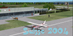
Neuchatel Airport (LSGN) for Suisse 2004
Re-upload of Neuchatel Airport (LSGN) Switzerland. A small place north west of Switzerland amongst the lake of Neuchatel, with a 800m runway. You can install it alone or in the same folder of all other Suisse 2004 sceneries.
| Filename: | Neuchatel_Airport_LSGN.zip |
| License: | Freeware |
| Added: | 9th May 2010, 09:36:14 |
| Downloads: | 9,463 |
| Author: | Daniel Gauthier |
| Size: | 3.63 MB |
| Category: Flight Simulator 2004 - Scenery | |
| Cape Verde Archipielago |
|
Images related to this file:
File Description:
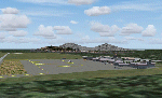
The Cape Verde Archipielago is an african country consisting in 10 islands located in the Atlantic Ocean some 600 kms. west of Africa.The islands are volcanic in origin and montanous. Cano peak rises to 2829 m on Fogo island
yout coordinates are 16 north and 24 west
| Filename: | Cape_Verde_Archipielago.zip |
| License: | Freeware |
| Added: | 14th September 2010, 00:24:42 |
| Downloads: | 2,692 |
| Author: | Toni Agramont |
| Size: | 14.92 MB |
| Category: Flight Simulator 2004 - Scenery | |
| VTUK Project Version 1.0.1 |
|
File Description:
This is VTUK scenery version 1.0.1 upgraded from version 1.0. VTUK or KhonKaen airport located in North-East of Thailand. Friendly with frame rates. Enjoy the flight in KhonKaen all comments welcome at my email. If you already version 1.0 installed. Replace it with this version.
| Filename: | VTUK_Project_Version_101.zip |
| License: | Freeware |
| Added: | 15th November 2003, 17:08:41 |
| Downloads: | 1,023 |
| Author: | Krit Thivavarnvongs |
| Size: | 448.45 KB |
| Category: Flight Simulator 2004 - Scenery | |
| Lucky Lake CKQ5 in Saskatchewan, Canada |
|
Images related to this file:
File Description:
The village of Lucky Lake is 80 miles south of Saskatoon, with a small population of less than 300, most of whom are dependant on agriculture for income, either directly or indirectly. Marijuana is a recently introduced crop after the failure of a government-financed potato growing operation called SPUDCO. The village was previously known as Devil's Lake (don't ask me, I don't know). The airfield is half a mile north of the village, with an asphalt runway just over 3,000 feet long, lit, and aligned 07-25 in FS9; this has now changed to 08-26 with the wandering magnetic north. Circuits on 25 are right handed to avoid over-flying the village. 100LL fuel is available.
| Filename: | Lucky_Lake_CKQ5_in_Saskatchewan_Canada.zip |
| License: | Freeware, limited distribution |
| Added: | 25th May 2017, 17:53:36 |
| Downloads: | 138 |
| Author: | Roger Wensley |
| Size: | 5.36 MB |
| Category: Flight Simulator 2004 - Scenery | |
| Southern Ontario Canada LOD 9 Mesh |
|
File Description:
Please note that I forgot to cut the one side of the screenshots so the right side of the image is what was present on my second monitor which in the first two pictures was my background.
The default mesh for Southern Ontario Canada was pretty flat and did not show the small rolling hills that are present throughout the province. This is LOD9 (90 meter) mesh that covers ALL of Southern Ontario from Elliot Lake, Sudbury and North Bay in the North, to near Montreal in the east, to Windsor in the southwest and all points in between. This mesh covers the entire area of Ontario shown in the Toronto VNC.
| Filename: | Southern_Ontario_Canada_LOD_9_Mesh.zip |
| License: | Freeware, limited distribution |
| Added: | 16th January 2004, 02:01:29 |
| Downloads: | 6,542 |
| Author: | David Voogd |
| Size: | 41.32 MB |


© 2001-2026 AVSIM Online
All Rights Reserved
Privacy Policy |