
Where Flight Simulation Enthusiasts Gather from Around the World!
AVSIM Library - Search Results

| Category: Flight Simulator 2004 - Scenery | |
| Fort Graham CBW3 in British Columbia Canada |

|
Images related to this file:
File Description:
Fort Graham is what looks like a very small village on the eastern shore of Williston Lake in northern British Columbia, around 100 miles north of Mackenzie (a previous post). The lake, while not large by Canadian standards, is well over 100 miles long but squeezed in width to a maximum of 5 miles amid the surrounding Rockies. The airfield has a gravel runway of 5,000 feet aligned 13-31 and at 2,230 feet ASL. There is no lighting. The operator of the airfield (and presumably the "village" too) is Finlay River Outfitters, a company that is based in Mackenzie and "outfits" hunting trips in the local area. I have posted this as Fort Graham CBW3, but I suggest that you just add it to your previously created "BC airfields" and avoid the inevitable doubling up of common textures etc. Up to you. If you find a defect, email me.
| Filename: | Fort_Graham_CBW3_in_British_Columbia_Canada.zip |
| License: | Freeware, limited distribution |
| Added: | 23rd November 2020, 20:13:11 |
| Downloads: | 108 |
| Author: | Roger Wensley |
| Size: | 7.75 MB |
| Category: Flight Simulator 2004 - Scenery | |
| CYQV Yorkton Municipal Airport Saskatchewan Version 2 |
|
Images related to this file:
File Description:
Yorkton Municipal Airport is situated approximately three kilometers north of the City of Yorkton, Saskatchewan, Canada. The airfield was built in 1940 for the Royal Canadian Air Force, as a British Commonwealth Air Training Plan station. Today, only a few of the wartime buildings remain and only two of the orginal four runways remain in operation. The airport continues, however, as the prinicipal hub of general aviation services for the east-central region of Saskatchewan.
CYQV was constructed using GMAX and represents the airport as it was in the Summer of 2008. It includes custom models of all the buildings at the airport, runway signs, refueling facilites,garages, weather station, fencing and trees, and a rotating beacon. CYQV includes custom ground textures to replicate the decommissioned runways and taxiways.
Version 2 replaces the original lost in the AVSIM hack and includes a number of improvements (see readme).
| Filename: | CYQV_Yorkton_Municipal_Airport_Saskatchewan_Versio.zip |
| License: | Freeware |
| Added: | 7th May 2010, 12:52:18 |
| Downloads: | 1,997 |
| Author: | Gregory Putz |
| Size: | 6.72 MB |
| Category: Flight Simulator 2004 - Scenery | |
| Seward PAWD in Alaska V2 plus 6AK5 |
|
Images related to this file:
File Description:
This is V2, the combined original and also V1. If you have already installed V1 then you do not need this. The town of Seward (population around 2,700) is on the east coast of the Kenai Peninsula, 70 miles east of Kenai town and also 70 miles southeast of Anchorage, amid mountains and glaciers at the northern end of the 20 mile long and fjord-like Resurrection Bay. It is also at the southern end of both the Alaska Railway and the Seward Highway, and has a sheltered dock for freight and also for cruise liners. Passengers from the liners can enjoy local attractions (dog sledging on a glacier?) and also easily continue further north by bus or train to Anchorage or to other tourist attractions such as Denali. The airport is next to the port and the town, with two runways aligned (in FS9, not taking account of the recently wandering magnetic north) 15-33 and 12-30, both asphalt and 2,100 and 4,200 feet long respectively. Only 12-30 (and its taxiways) is lit, with VASI on 30. There are no regularly scheduled flights to Seward; with buses and trains running direct from Anchorage there is no money to be made. There are some charter flights coordinated with cruise liners, and some freight flights, the very occasional visit by the Coastguard, but most flights are GA, air taxi,or short scenery-viewing trips for summer tourists. In a mountainous area the only sure thing about the behaviour of AI aircraft is that it is unpredictable but often involves a mountain; nothing to be done about it. At Seward there is also marine AI from and to the port, in the shape of a cruise liner and an Alaskan ferry, but the latter only if you have Holger Sandmann's Alaska scenery installed. Also included with this is a correction for Fire Island 6AK5, near Anchorage, that takes the airfield out of the water; this is something I have meant to do for the last 5 years.
| Filename: | Seward_PAWD_in_Alaska_V2_plus_6AK5.zip |
| License: | Freeware, limited distribution |
| Added: | 19th January 2016, 18:27:26 |
| Downloads: | 591 |
| Author: | Roger Wensley |
| Size: | 12.47 MB |
| Category: Flight Simulator 2004 - Scenery | |
| Twin Lakes Airstrips in British Columbia Canada |
|
Images related to this file:
File Description:
There are three grass airstrips within sight of each other from the air at Twin Lakes in BC, which is between the close junction of Elkin Lake and Vedan Lake. The two lakes are similarly shaped and sized and in the same narrow valley between high ground that runs north-south; hence the name. Elkin is to the north, and Vedan is to the south. Twin Lakes CAG4 is on the strip of land between the two lakes and it is unclear to me who it belongs to etc. It is not in the Nav Canada copy that I have with me which is from 2010, and the online version does not cover grass strips. It is probably owned by whoever lives in the house next to the red hangar. The runway is 3,600 feet of grass aligned 14-32 at 3,945 feet ASL. Chaunigan Lake Lodge CF83 is over to the northwest from Twin Lakes by around 2 miles or so and as the name suggests it services the Lodge of that name, which is on the northeast corner of Chaunigan Lake. The runway is 2,600 feet of grass aligned 02-20 at 4,900 feet ASL. You might want to read about altitude power reductions for the take off. Elkin Creek Guest Ranch CBL9 is at the southern end of Vedan Lake and serves the ranch. This appears to be another high-budget operation and the runway is 3,670 feet of grass aligned 36-18 at 3,999 feet ASL. I have posted this as three separate airstrips, but I suggest that you add these to your "BC airfields" folder as previously suggested. Up to you. If you find a defect, email me. Ignore the post of Chilanko Lodge posted today. I requested Avsim to delete it but it seems they didn't read the email. It was originally posted as a correction for the original post of the three posted here.
| Filename: | Twin_Lakes_Airstrips_in_British_Columbia_Canada.zip |
| License: | Freeware, limited distribution |
| Added: | 21st November 2020, 23:29:09 |
| Downloads: | 126 |
| Author: | Roger Wensley |
| Size: | 25.39 MB |
| Category: Flight Simulator 2004 - Scenery | |
| PAEN, PAEX, 3AK4, 30AK, 52AK - Alaska, USA |
|
Images related to this file:
File Description:
The town of Kenai is on the east coast of Cook Inlet, 60 miles southwest of Anchorage. The airport is in the northern part of the town, with a runway aligned 1-19, 7,550 feet long and 150 feet wide (with an ILS on 19). A second runway is gravel, 2,000 feet long and for winter use by ski planes. There is also a water runway, and all three are aligned the same and called "1 left-19 right" (the main runway) "1 right-19 left" (gravel) and "1 water-19 water". The taxiways are extensive and designed for a far larger traffic than the airport has today, though even now the airport is fairly busy. In FS9 a water runway for AI cannot work with an ATC control tower; the water part of PAEN has therefore been separated into another call sign PAEX which has ONLY the water runway; the tower will therefore direct the plane that makes contact to use the water runway. The PAEN airport runway has taxiway connections at each end and also two intermediates; at the northern end there are in fact two so a total of 5; B, C, D, E, and F; there is an airport diagram included. GA traffic goes to one of two parking aprons, both at the southern end, and at the far southern end there is the hangar for the Civil Air Patrol. The AI includes aircraft from my previous Alaska posts, as Kenai is where I sent them when they departed from, for instance, Palmer. Airlines and cargo companies that operate from and to Kenai are included in the AI: ERA (which has recently changed it's name), Grant Aviation, Air North, Wings of Alaska, North Star Air, and a small local company Air Supply Alaska, along with Fedex, UPS, Everts, and Northern Air Cargo. There is also GA and float AI. Nearby smaller airfields are included, partly because one of them was dramatically misaligned in FS9.
| Filename: | PAEN_PAEX_3AK4_30AK_52AK___Alaska_USA.zip |
| License: | Freeware, limited distribution |
| Added: | 26th December 2015, 15:33:19 |
| Downloads: | 485 |
| Author: | Roger Wensley |
| Size: | 23.08 MB |
| Category: Flight Simulator 2004 - Scenery | |
| Dawson Creek CYDQ in British Columbia, Canada |
|
Images related to this file:
File Description:
Dawson Creek is at 2,148 feet asl just east of the Rocky Mountains, less than 10 miles west of the BC/Alberta border. The Peace River, 25 miles north of Dawson Creek, links the two sides of the Rockies, winding through peaks that reach up almost to 8,000 feet. The population grew when the Northern Alberta Railway was extended to Dawsons Creek in 1932, and grew even more more when the Alaska Highway was built in 1942 and Dawsons Creek was where it started from. The airport is just to the east of the town. The runway is 5,000 feet of wide asphalt (150 feet) aligned 06/24, lit, and with PAPI and approach lights. There is a water runway to the north of the main runway with the same alignment, separately designated as Dawson Creek CBD3. The two operate as one; traffic for both use the mandatory frequency of 122.2 and talk to one controller in one control tower. However, in FS9 the ATC for two separately designated airfields operates as if they are nowhere near each other and near misses are the result. I have put them both in un-manned tower mode so you will announce your position and intentions and select your own parking spots etc. There is in reality a lack of apron markings but I have marked the positions of both gates. The apron is not large so there is only one other apron parking spot (see the traffic cone) and most parking is either next to one of the hangars or on the grass. The aprons vary from asphalt, to concrete, onwards to gravel, and then further onwards to some gravel amid the bare dirt; I have replicated this variation as far as FS9 permits. The buildings are bespoke from photos. The AI includes Central Mountain Air with two daily scheduled flights and Northern Cariboo as one of the airlines that occasionally runs charter flights in CYDQ. There are also private GA flights, and float plane flights into and out of CBD3.
| Filename: | Dawson_Creek_CYDQ_in_British_Columbia_Canada.zip |
| License: | Freeware, limited distribution |
| Added: | 22nd November 2013, 23:31:40 |
| Downloads: | 653 |
| Author: | Roger Wensley |
| Size: | 16.65 MB |
| Category: Flight Simulator 2004 - Scenery | |
| Talkeetna Village AK44 in Alaska, home of Don Sheldon's Talkeetna Air Service |
|
Images related to this file:
File Description:
Talkeetna is around 75 miles north of Anchorage in Alaska on the east shore of the Susitna River. The town is where Don Sheldon got off the train in 1938, and where, ten years later, he started Talkeetna Air Services. There are two airfields in Talkeetna, PATK with its long asphalt runway and Talkeetna Village AK44 in the middle of the town. This is AK44; the default FS version with Ultimate Terrain installed had the runway half in the river, but there is still space for the 900 feet of runway that is described in the book "Wager With The Wind" that tells Don's story. The result is a step back in time to 1973, when the second hangar was built. If you also want to install PATK do a search. I have partially populated the village with cabins, and UT is probably required for the river to be there; I haven't tested this without it.
| Filename: | Talkeetna_Village_AK44_in_Alaska_home_of_Don_Sheld.zip |
| License: | Freeware |
| Added: | 4th February 2010, 01:24:40 |
| Downloads: | 564 |
| Author: | Roger Wensley |
| Size: | 3.66 MB |
| Category: Flight Simulator 2004 - Scenery | |
| Buffalo Narrows CYVT in Saskatchewan, Canada |
|
Images related to this file:
File Description:
Buffalo Narrows is a small town (around 1,400 folks) 130 miles west and a bit north of La Ronge in Saskatchewan, and I discovered that the Buffalo Narrows airfield, wrongly positioned in FS9, had been flooded out by Ultimate Terrain's lake; this is the rescue package. Actually that would be several lakes as the place is surrounded by water including Churchill Lake, Little Peter Pond Lake, and of course Big Peter Pond Lake.
There are two runways, the longest being 5,006' of 100' wide asphalt aligned 11/29, and the other 2,297 and 75' wide, also asphalt. Both runways are lit, and there is JetA and 100LL fuel available. I have placed taxiway lights, but I haven't made proper signage or placed runway lights, or a ton of other things, but it is now landable and with the buildings and fire chemical retarder tanks etc, and there is AI that includes a CL-415. The roads have also been modified to fit.
| Filename: | Buffalo_Narrows_CYVT_in_Saskatchewan_Canada.zip |
| License: | Freeware, limited distribution |
| Added: | 15th July 2012, 19:31:20 |
| Downloads: | 499 |
| Author: | Roger Wensley |
| Size: | 1.8 MB |
| Category: Flight Simulator 2004 - Aircraft Repaints, Textures and Modifications | |
| South West Aviation, Douglas DC-3 |
|
Images related to this file:
File Description:
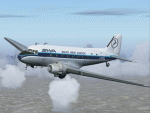
South West Aviation started at Exeter in 1966 commencing operations with a Piper Aztec. By early 1968 the airline had grown and acquired a Shorts Skyvan on lease and had established footholds at Bristol Lulsgate and Swansea as well as Exeter. Late 1968 they acquired their first DC3 aircraft G-APBC which operated numerous charter flights within UK and to Ireland and the rest of Europe. It was used for airborne filming of the 'Torrey Canyon' and Aberfan disasters. A second DC3 G-AMYJ was acquired in 1969. Initially the DC3's carried out most of their flying from SW England and S Wales. However, in April 1969 'BC started charter operations between Norwich, Tesside and Aberdeen in support of the North Sea oil industry. 1970 saw the introduction of scheduled air services to Cherbourg from both Exeter and Southampton using the DC3. In 1972 SWA were bought out by Ashford based Air Freight Ltd and the name of South West Aviation disappeared. Requires default DC-3.
| Filename: | South_West_Aviation_Douglas_DC3.zip |
| License: | Freeware |
| Added: | 22nd March 2011, 17:13:17 |
| Downloads: | 632 |
| Author: | John Payne |
| Size: | 4.87 MB |
| Category: Flight Simulator 2004 - Scenery | |
| Redcliffe & Caboolture Airports, Queensland |
|
File Description:
THese are my latest versions of these two great little General Aviation airports for FS9 (FS2004)
Redcliffe is the next biggest general aviation airport in the Brisbane region after Archerfield.This version is a fairly close representation of the real thing which is the home of 2 flying schools. Many ga and also sport aircraft are hangered here. Watch out for the swamp at either end of the runway.... quite a few aircraft over the years have landed there by accident! Redcliffe is also notorious for crosswinds which can make takeoffs and landings interesting at this airport.Caboolture is a wonderful little grass strip about 10 minutes flying north of Redcliffe. The airstrip dates back to WWII and is the home of a strong warbird/vintage aircraft restoration industry, 3 flying schools, a glider club and also a large ultralight fraternity. Caboolture can be a busy little airport on the weekends and a Vintage GA aircraft spotters paradise!
| Filename: | Redcliffe__Caboolture_Airports_Queensland.zip |
| License: | Freeware |
| Added: | 24th September 2003, 00:56:27 |
| Downloads: | 1,429 |
| Author: | Steve James, Mal Lloyd |
| Size: | 2.74 MB |


© 2001-2026 AVSIM Online
All Rights Reserved
Privacy Policy |