
Where Flight Simulation Enthusiasts Gather from Around the World!
AVSIM Library - Search Results

| Category: Flight Simulator 2004 - Aircraft Repaints, Textures and Modifications | |
| Hellenic Air Force, Lockheed F-104 Starfighter |

|
Images related to this file:
File Description:
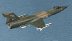
Hellenic Air Force F-104 textures for the ALPHASIM F-104 payware model. The F-104 has gained many 'nick-names' through-out its long career in many air forces around the world. Some of these include 'Widow Maker', 'Manned Missile', and 'Flying Coffin'!
The Hellenic Air Force had a very good track record with this aircraft. Greece originally received 45 F-104Gs and 6 TF-104Gs under the US MAP (Military Assistance Program) in 1964. In 1972 used planes started to be bought with nine more F-104Gs and one TF-104G aircraft acquired from Spain, ten more F-104Gs from the Netherlands in 1982. The largest purchase came when a further thirty eight F-104Gs, twenty two RF-104Gs and twenty TF-104Gs were bought from West Germany. The West German planes were acquired mainly between 1981 and 1988. With one hundred second hand planes, some were mothballed and used as spare parts. Originally flown with just the natural metal finish they eventually were given a camouflage 3 color paint scheme on top of olive drab / dark green / sand, the bottom was a light grey.These planes were flown by two Greek squadrons, the first being 335 Mira from the 114 Pterix (Wing) based at Tanagra AB. The second was 336 Mira, also based at Tanagra AB at the time. December 21st 1966 saw 336 Mira move to a new base at 116 Pterix at Araxos AB.
The F-104 went on in the Hellenic Air Force service until 1993 when 336 "Olympus" Mira Diokseos Bombardismou (Fighter-Bomber Squadron) was deactivated March 31.
| Filename: | Hellenic_Air_Force_Lockheed_F104_Starfighter.zip |
| License: | Freeware |
| Added: | 4th May 2010, 09:49:57 |
| Downloads: | 625 |
| Author: | Leonidas Theofilopoulos |
| Size: | 3.55 MB |
| Category: Flight Simulator 2004 - Scenery | |
| Chennai airport for fs9/Fs2004 |
|
File Description:
Hi everyone
This is my first project, and it took 6 months to complete. This is a freeware airport, but I have tried to put in as much detail as I possibly can. I made this airport because FS9 did not have very many good-quality payware or freeware airports, so I decided to make an airport for my home country. Some general info for the airport is below:
Chennai International Airport (MAA), located in Meenambakkam, is the primary airport serving Chennai, Tamil Nadu, and the southern part of India. It has two terminals: Terminal 1 for domestic flights and Terminal 2 for international flights. The airport is known for its modern infrastructure and facilities, including shopping areas, lounges, dining options, and passenger services. It is an important hub for domestic and international travel, especially for travelers heading to South Asia, Southeast Asia, and the Middle East. The airport also has strong connectivity via road and metro.
Features of the scenery:
1)Has the latest terminal and airport layout since I used the latest data
2)added buildings to the surroundings (Custom 3d model made from scratch even the terminals)
3)has partial photoreal scenery(will talk about issues in bugs area)
4)has good jetbridges
5)3d volumetric grass in certain parts(will talk about issues in bugs area)
6)taxiways designed as in real life
7)Includes parked cars, lights, nearby buildings
8)Added lots of ground equipment
9)Trees around the airport
10)airport perimeter walls
11)Used Lh simulations library for some buildings and volumetric grass
Known bugs:
1)photoreal scenery has some issues since I can't get my photoreal scenery maker to work properly
2)Papi lights are kinda bugged
3)3d volumetric grass is limited to some parts due to fps loss
How to install:
1)Download file
2)Extract from rar using WinRaR or other program
3)paste vomm in the addon scenery of your flight sim installation directory and add scenery in settings once you open fs9
4)Includes better default textures for aprons and taxiways (optional!!!!!)
5)enjoy!!
Reminder: This airport does not have custom taxiways or aprons the default textures modified by me are the ones used in the picture. If you decide to replace your default files with mine all your airports globally(default) will have these textures for taxiways and aprons.
Tested to run on low-end devices with minimal lag
will run well on better devices
Hope you enjoy this completely freeware scenery and always read the above instructions to avoid unnecessary scenery limitation discussions.
Thank all you fs9 folks.
Download link: https://sharemods.com/imxa719wg065/Chennai_airport_fs9.rar.html
| Filename: | Chennai_airport_for_fs9Fs2004.zip |
| License: | Freeware |
| Added: | 18th January 2025, 01:22:51 |
| Downloads: | 249 |
| Author: | Jeremy(lol890) |
| Size: | 92.14 MB |
| Category: Flight Simulator 2004 - AI Flight Plans | |
| Sorted default FS9 flight plans & GA flight plans sorted by ICAO/country |
|
File Description:
The Master_GA_sorted_country contains: some 20,436 flight plans that have been adopted from Reggie Fields' sorted aircraft registration collections. The following is from his readme file (included folder), "FS2004 General Aviation AI traffic with more correct registration numbers for the originating country. This file is a modification of the FS2004 default GA traffic designed to minimize the number of small single engine aircraft landing at the worlds major commercial airports. This will prevent a lot of go-around orders to commercial jets based on the length of time it takes a C172 to clear a 10,000 ft runway. This file makes commercial AI traffic flow much better than the MS default while retaining the GA aircraft in the airspace." Like Reggie Fields' files, all are free to use and redistribute but can not be sold. AC#defaultfp_sorted_ICAO folder contains all individual default aircraft in seperate files and their FS9 default flight plans are sorted by ICAO. A second folder contains a file for each country with the mentioned GA flight plans sorted by ICAO. This should be of an aide to those of us who wish to put more correct AI aircraft into a region or country. Copy/paste should be easier, this way, when building on each countries' aviation/flights. All files are text (.txt) files (ASCII.) They have no @ and TTOOLS by Lee Swordy is recommended.
| Filename: | Sorted_default_FS9_flight_plans__GA_flight_plans_s.zip |
| License: | Freeware |
| Added: | 10th May 2004, 14:48:30 |
| Downloads: | 2,983 |
| Author: | Rick Connolly |
| Size: | 5.57 MB |
| Category: Flight Simulator 2004 - Miscellaneous Files | |
| Active ILS - KMIA (Miami International Airport) |
|
File Description:
By design KMIA is now the most advanced ATC controlled airport in the FS9 database. This is the 4th Airport and the most complex in a series of new ILS runways. As most know initiating the ILS at certain airports for AI Traffic is not a function at this time when using AFCAD2. If you add a new ILS runway to an airport such as KMIA (Miami International Airport 8L/26R) only the user aircraft can use this runway when visibility falls below 3 miles. ATC will no longer use this runway for AI Traffic because FS9 sees it as a visual runway. This will cause ATC to vector your AI Traffic back to 9L/27R (old numbers) 8R/26L (new numbers) which is also a Terminal departure runway. All 4 runways for KMIA are now simultaneously active for both departure and arrival. In the past only the runways closest to the Terminal were for departure, and arrivals used the outer parallel runways. This no longer applies with KMIA. The many options written in the XML are to numerous to list for KMIA so follow the instructions in the README and just sit back (or fly) and plane spot either VMC or IMC for a very active airport.
*** FlyTampa-Miami Scenery AFCAD2 and special ILS bgl also included ***
| Filename: | Active_ILS__KMIA_Miami_International_Airport.zip |
| License: | Freeware, limited distribution |
| Added: | 4th July 2004, 03:33:01 |
| Downloads: | 2,217 |
| Author: | Jim Vile |
| Size: | 128.67 KB |
| Category: Flight Simulator 2004 - Miscellaneous Files | |
| Active ILS - LEBL (El Prat - Barcelona Airport) |
|
File Description:
As most know initiating the ILS at certain airports for AI Traffic or the User Aircraft is not a function at this time when using AFCAD2. If you add a new ILS runway to an airport such as LEBL (El Prat/Barcelona 7R/25L) only the user aircraft can use this runway (without ATC commands) when visibility falls below 3 miles. ATC will no longer use this runway for AI Traffic because FS9 sees it as a visual runway. This will cause ATC to vector all your AI Traffic back to runway 7/25 old numbers, 7L/25R new numbers which is also a Terminal departure runway. This ILS bgl file adds all NAVAIDS for making 7R/25L a Precision Instrument Runway by adding all the radar fixes for both the ILS approach portion and the missed approach procedures, altitudes and intersections as per current published plates. All AI Aircraft/User Planes will now continue to use the new 7R/25L runway when Airport weather conditions are less than 3 miles. ATC will also use the right naming/numbers of the runways. The DME/VOR approaches have also been written using the new BCN/PRA VOR's for runways 7L/25R and 02. Many different default FS9 scenery GUID's added including Taxiway Signs *** FS2004 Default Scenery AFCAD2 included with the new 7R/25L runway ***
| Filename: | Active_ILS__LEBL_El_Prat__Barcelona_Airport.zip |
| License: | Freeware, limited distribution |
| Added: | 30th December 2004, 17:53:42 |
| Downloads: | 2,842 |
| Author: | Jim Vile |
| Size: | 31.51 KB |
| Category: Flight Simulator 2004 - Scenery | |
| Hazyview Airfield, Hazyview, South Africa |
|
Images related to this file:
File Description:
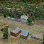
Hazyview is one of the gateway towns to the Kruger National Park and is located just to the West of Phabeni Gate, one of the main gates to use if you are travelling to Skukuza. The airfield in Hazyview is also called Numbi Airfield due to the location of the Numbi Hotel right next to the airfield.
Hazyview airfield is not included in the default scenery of FS2004. With this package, it has been faithfully produced in Gmax with photoreal textures on all the buildings and a photoreal ground as well. Even the Lowveld mall to the North of the airfield and right on the approach to Rwy 19 as well as the Building supplies store to the south and on approach to Rwy 01 is inlcuded with custom models and textures. Likewise, the buildings to the West of the runway (right at the edge of the runway) and the brickyard at the Northern end is modeled with custom models and textures. The two large cellphone antennas are also present in the airport scenery and custom made.
In real life, the runway is quite sloped and this was also recreated in the scenery under the limitations FS2004 presents with regards to non-flat airports.
The grass runway is aligned 01/19 and only 820m long. Take-off is on Rwy 01, with landings on Rwy 19.
| Filename: | Hazyview_Airfield_Hazyview_South_Africa.zip |
| License: | Freeware, limited distribution |
| Added: | 4th February 2022, 14:57:40 |
| Downloads: | 143 |
| Author: | Kobus van Wyk |
| Size: | 17.07 MB |
| Category: Flight Simulator 2004 - Flight Plans | |
| Crossing North America Flight Adventures-Package 3 |
|
File Description:
Inspired by Michael Doherty (Difficult & Dangerous Approaches) and David Dossiere (Hopping Round the World) and their flight adventures, I have put together a series of flight plan-adventures where the aircraft used are all available as freeware. A file locator is included with each package so that you can easily find and download the aircraft used. These packages each contain 10 flight adventures and each package begins at the location the previous package ended. All flightplans are VFR only and are designed so that you can enjoy the outstanding scenery of Alaska, Western Canada, Western and Mountain States of the lower 48, and Mexico.
The adventure, Crossing North America, begins at Pt Hope, Alaska and will conclude in the following months at Cancun, Mexico. The aircraft used are: General Aviation, Vintage, Warbirds, Bush Aircraft, and Propliners. No IFR flightplans or jets!
The flightplans are NOT designed to get you from Alaska to Mexico by the shortest route possible, but are in the spirit of David Dossiere's "Hopping Round the World" adventure flights, in that they take you into as many areas or airports as possible. Looking for some fun, flying low, and enjoying the scenery, then these flight adventures are for you.
Todate: 3,769 miles covered, using 26 different aircraft in the first 3 flight packs!
| Filename: | Crossing_North_America_Flight_AdventuresPackage_3.zip |
| License: | Freeware |
| Added: | 6th July 2004, 14:46:46 |
| Downloads: | 4,074 |
| Author: | Steve (Bear) Cartwright |
| Size: | 1.37 MB |
| Category: Flight Simulator 2004 - Scenery | |
| New Night Textures - Newark Liberty Intl (KEWR) |
|
Images related to this file:
File Description:
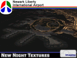
Some time ago, I purchased the Newark Liberty Intl (KEWR) by ImagineSim, but the night textures did not seem realistic. I set out to try to make them more so. This is the result of that work. Many of the scenery's night textures have been updated. The cargo areas for FedEx, UPS and UNITED Cargo now look much more realistic. The Marriott Hotel, the centerpiece of the airport and this scenery, looks considerably more realistic, as well as the terminals and the Continental Hanger and maintenance area. One of the nice unexpected results of this change is the light splash effect around the terminals; it definitely outlines the terminal area well. For those who own this scenery, I hope this enhances your flight experiences in and out of KEWR. For those who do not yet own this, but enjoy or would like to fly in and out of KEWR, it is now considered a legacy product by ImagineSim. As a result, the price was cut considerably and for a few shillings and this update, you'll have a nice addition to the airports in your FS2004 environment. I dedicate this work to all the controllers of VATSIM NYARTCC. I hope this brings more traffic your way. I want to thank ImagineSim for giving me permission to release these textures. See Readme.txt for installation instructions.
| Filename: | New_Night_Textures__Newark_Liberty_Intl_KEWR.zip |
| License: | Freeware, limited distribution |
| Added: | 27th October 2012, 03:48:59 |
| Downloads: | 2,293 |
| Author: | Jeffrey S. Bryner, Imagine Simulation |
| Size: | 1.97 MB |
| Category: Flight Simulator 2004 - Scenery | |
| Bethel PABE in southwest Alaska |
|
Images related to this file:
File Description:
There are four main northwestern Alaska towns which have good airports and are serviced by Alaska Airlines. From these airports local flights connect to nearby villages, "nearby" in Alaska meaning up to 200 miles away. The northernmost is Barrow. Southwest of Barrow is Kotzebue, then Nome, and the furthest south is this one, Bethel. The town of Bethel has a population of just over 6,000 and is 50 miles from the sea on the Kuskowim River, that splits and forks into many tributaries. Bethel Airport is close to the town and provides the only contact with the rest of Alaska, as there is no connecting highway system. There are scheduled flights by Alaska Airlines, ERA (now called Ravn) and Grant Aviation, plus others such as Ryan Air. There are cargo flights by Everts, Northern, and Lynden, and redistribution onwards to nearby villages by the smaller locally-based planes; all of these are included in the AI. There are two main runways, one just under 6,400 feet and another just under 3,900 feet, both of them aligned 19-1. The third runway is around 1,800 feet and mainly gravel, aligned 11-29. Parking at PABE is on three aprons, the northern for smaller commercial planes of Grant, ERA, Ryan etc, the central for larger planes of Alaska, Northern, Everts, and Lynden, and the southern for a large collection of GA; each apron has further hangars for maintenance companies and smaller operators. There is also another separate apron for the local military and Coastguard. There is not much photographic information available for PABE, and I have never been there; as a result it was impossible to make detailed photographic textures for some of the buildings. However, for most hangars I have made textures of at least the right colour etc based on the information I assembled and if it is green with white trim and side windows then that is how it now appears here. The exceptions are the Alaska Airlines terminal building which has complicated curved elements, and the two military hangars and workshops where I had to settle for an Alaska terminal building from another airport and the same for the military. There are numerous small villages in the vicinity of Bethel, all of them being beside either a river tributary or the coast. There are two Google Earth screenshots to show the villages that are served by the flights from Bethel and that are (mostly) included in the AI. Some of these airfields were not included in FS9 but AI will still operate in and out of Bethel. The smaller area screenshot shows the villages that are close to Bethel, and of these eight I have so far made six and they are included in this post: Napaskiak PKA, Napakiak WNA, Kwethluk KWT, Atmautluak 4A2, Nunapitchuk 16A, and Kasigluk Z09. I will work my way through the rest of the area.
| Filename: | Bethel_PABE_in_southwest_Alaska.zip |
| License: | Freeware, limited distribution |
| Added: | 8th March 2019, 00:37:58 |
| Downloads: | 310 |
| Author: | Roger Wensley |
| Size: | 32.02 MB |
| Category: Flight Simulator 2004 - Scenery | |
| Sioux Lookout CYXL in northern Ontario, Canada, updated |
|
Images related to this file:
File Description:
This greatly modifies my previous post of Sioux Lookout; it is stand-alone and does not require you to have the 2009 version. The AI provided with the post complements what was included with Dryden (March 2013). Sioux Lookout is in northern Ontario, 40 miles east of Dryden, and 145 miles northwest of Thunder Bay. The town is on the northeastern shore of a lake that I don't know the name of (I've been there, but has anyone COUNTED how many lakes Canada has?). It has a population of around 5,000. The main businesses are lumber, tourism, and health care. The airport is immediately adjacent to the northeastern corner of the town, and has 5,300' of asphalt which is aligned 16-34. There are two taxiways which curve and climb up to the apron which is 20 or 30 feet higher. When you taxi on them the knowledge that in reality you would be climbing makes sense of the curved routing. The apron is large and a mixture of asphalt and gravel. I did not make the terminal building and I have no photo or even a recollection of what it looks like, so you should first install Northwest Ontario Airports by Eric O'Link as he has a terminal building for CYXL that might be how it looks; some of his airfields collide with other and newer versions and I have kept only his CYXL and CYPL bgl's.
| Filename: | Sioux_Lookout_CYXL_in_northern_Ontario_Canada_upda.zip |
| License: | Freeware, limited distribution |
| Added: | 19th March 2013, 19:23:24 |
| Downloads: | 405 |
| Author: | Roger Wensley |
| Size: | 5.08 MB |


© 2001-2026 AVSIM Online
All Rights Reserved
Privacy Policy |