
Where Flight Simulation Enthusiasts Gather from Around the World!
AVSIM Library - Search Results

| Category: Flight Simulator 2004 - Scenery | |
| Scenic Mountain Getaway |

|
File Description:
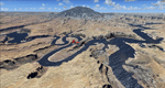
A private cabin in a remote area of the Cascades sitting atop a plateau high on the side of a mountain. Offers a lakefront view ahead and a view of the vast green valley behind. There is a very small, makeshift airstrip only a few feet from the cabin marked with orange cones and dwarfed by towering trees at the landing end. There’s only one way in & out of this strip, a missed approach is not an option! Includes cabin, “airstrip,” 2 boats, picnic tables, bbq, a tool chest, storage boxes & crate, oil/fuel barrels, a small T-hanger, spectacular views and much more! Requires Rwy12 libraries and Holger Sandmann’s, “US North Cascades Mountains and Northwest Washington Coast” (us_wa_nc.zip). By, Kevin Yetman
| Filename: | mtgtawy.zip |
| License: | Freeware |
| Added: | 25th August 2005, 13:20:20 |
| Downloads: | 1,216 |
| Author: | Kevin Yetman |
| Size: | 748 KB |
| Category: Flight Simulator 2004 - AI Aircraft | |
| Israeli Air Force Part 5 - Ramat David Air Base |
|
Images related to this file:
File Description:

Ramat David Israeli Air Force Base, is one of three principal airbases of the Israeli Air Force. It is located in the north of Israel, southeast of Haifa, close to kibbutz Ramat David in the Jezreel Valley. It was originally built as a Royal Air Force station in 1942 under the British Mandate, when it was known as RAF Ramat David. The base hosts three F-16's Squadrons (109th; 110th; 117th), and the 193th Sqn on Eurocopters AS-565 (not represented in this pack).
AFCADs: Giorgio Perotti and MAIW Team, Models: Henry Tomkiewicz, FDE and Effects Design: John Stinstrom,
Henry Tomkiewicz and Nick Needham, Repaints: Maurizio Coren, Voicepacks: Stewart Pearson,
Flightplans and Custom Scenery: Giorgio Perotti, Scenery objects: John Stinstrom and Ted Andrews.
| Filename: | maiw_iaf_part_5_-_ramat_david_giorgio_perotti.zip |
| License: | Freeware |
| Added: | 24th January 2014, 21:26:38 |
| Downloads: | 464 |
| Author: | MAIW - Giorgio Perotti |
| Size: | 32.14 MB |
| Category: Flight Simulator 2004 - Scenery | |
| Lake Powell, Navajo Mountain (04UT), Utah/Arizona, Photo-Scenery (FS9 & FSX) |
|
Images related to this file:
File Description:
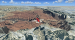
This package contains the center of Lake Powell and the Navajo Nation around Navajo Mountain. It contains remote areas of stunning beauty. Wonderful sandstone formations in bright shades of red and pink. Contains landmarks like the Rainbow Bridge National Monument and the confluence of the Colorado and San Juan Rivers. Extends my Monument Valley scenery to the west and brings you another 3.500 sq km in 4.7m/pix quality. To explore the scenery depart from Navajo Mountain dirt strip (04UT). High resolution versions of this scenery for FS9 and FSX (much sharper, but larger and multiple downloads) are available at www.blueskyscenery.com/CNY_South3West2.html . The screenies are taken from the high-res versions, so expect this version to be slightly more blurry. YourDonation@Work: Joaquin, Donald and Scott.
| Filename: | cny_south3west2_2010_lr.zip |
| License: | Freeware, limited distribution |
| Added: | 23rd January 2010, 23:06:49 |
| Downloads: | 1,766 |
| Author: | Gottfried Razek - blueskyscenery.com |
| Size: | 91.43 MB |
| Category: Flight Simulator 2004 - Scenery | |
| Capitol Reef National Park/North - Hanksville (KHVE), Utah, Photo-Scenery |
|
Images related to this file:
File Description:
Capitol Reef National Park/North - Hanksville (KHVE), Utah, Photo-Scenery (for FS9 & FSX)
This scenery covers the northern part of Capitol Reef National Park, Hanksville (KHVE), the Goblin Valley and extends north to I70 and the San Rafael Swell. It extends my Canyonlands sceneries to the west and brings you another 3.500 sq km in 4.7m/pix quality. To explore the scenery depart from Hanksville (KHVE) and head northwest. High resolution versions of this scenery for FS9 and FSX (much sharper, but larger and multiple downloads) are available at www.blueskyscenery.com/CNY_West2.html . The screenies are taken from the high-res versions, so expect this version to be slightly more blurry. YourDonation@Work: Dedicated to Andy and Robert.
| Filename: | cny_west2_2010_lr.zip |
| License: | Freeware, limited distribution |
| Added: | 13th January 2010, 19:32:33 |
| Downloads: | 1,678 |
| Author: | Gottfried Razek, blueskyscenery.com |
| Size: | 94.77 MB |
| Category: Flight Simulator 2004 - Scenery | |
| City of Edmonton |
|
File Description:
Addon scenery project for City of Edmonton, Alberta, Canada, for FS2004. This is a FREEWARE project, created by Brian Sturton, and with special thanks to Joel Gill and Her Majesty the Queen for the included rail.bgl file. Transforms the generic dull scenery around CYXD airport, into a detailed replica of the actual city. Features include a detailed representation of the downtown area, along with most other major structures that would be visible from the air; reflective "glass" buildings; more accurate rendition of West Edmonton Mall (compared to my earlier offering); reworked landclass and elevation values, which permit a nicer rendition of the river valley, as well as the urban areas south of the river; repositioned river sections; bridges; refineries to the east of the city; outlying towns; major roads, and modifications to CYEG and CYYC.
| Filename: | edmonton_city.zip |
| License: | Freeware, limited distribution |
| Added: | 7th May 2006, 03:03:44 |
| Downloads: | 6,373 |
| Author: | Brian Sturton |
| Size: | 5.98 MB |
| Category: Flight Simulator 2004 - Scenery | |
| McMinnville, Oregon - KMMV - Evergreen Museum, Home of the Spruce Goose |
|
Images related to this file:
File Description:
FS2004 Scenery - KMMV - Evergreen Museum. Located in the beautiful Willamette Valley, some 40 miles South of Portland, Oregon, McMinnville Municipal Airport (KMMV) serves McMinnville and Yamhill County and is owned by the City Of McMinnville, Oregon.
The airport is the home of the Cascade Soaring Club and Evergreen International, a global aviation services company. Adjacent to the airport is the new Evergreen Aviation Museum whose centerpiece is the famous "Spruce Goose".
This scenery includes a replica of the Museum and the new IMAX theater. Requires EZ Scenery Libraries. Installations included for default FS9 roads or for users who have USA Roads installed. Lago FSE optional. IMPORTANT!! PLEASE READ THE README FILE!!! Please unzip (using folders option) to a temporary folder. Created by John B. Loney, Jr and David "Opa" Marshall.
| Filename: | kmmv_v1.zip |
| License: | Freeware |
| Added: | 1st February 2010, 11:37:39 |
| Downloads: | 2,574 |
| Author: | John B. Loney, Jr and David "Opa" Marshall |
| Size: | 4.07 MB |
| Category: Flight Simulator 2004 - Scenery | |
| Perrine Bridge, Twin Falls Idaho Updated |
|
Images related to this file:
File Description:
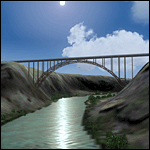
A prominent VFR landmark near Twin Falls Idaho, the Perrine Bridge spans over 1600' and stands 486 feet above the river below. At one time it was the tallest bridge in the world. Perrine Bridge is the only man-made structure in the USA were "base jumping" is allowed without a permit 365 days out of the year. Download includes gmax bridge object, a small photoscenery for the surrounding area, and two saved flight scenarios for exploring the scenery in the default J3 Cub. Bridge surface is landable and crash box has been removed allowing flight beneath the bridge. Scenery is compatible with, and nicely compliments John B. Loney's "Joslin-Magic Valley Regl" airport scenery (ktwf_v1.zip). Requires Ultimate Terrain and freeware mesh product, links provided in the readme.
| Filename: | perrine_fs9.zip |
| License: | Freeware, limited distribution |
| Added: | 5th July 2011, 04:28:11 |
| Downloads: | 402 |
| Author: | Jim Robinson |
| Size: | 1.52 MB |
| Category: Flight Simulator 2004 - Miscellaneous Files | |
| Emma Field Sightseeing Tour Release III |
|
File Description:
Fly a VFR-tour in the area around Seattle, Washington. You will need some skills of bush-flying. Included in this package are a detailed tour-description, maps (one per stage), situation- and WX-files (also per stage). You will leave from Emma Field (KEWL) and visit the following airfields: Forks (S18), Sekiu (11S), Sequim Valley (W28), Orcas Island (KORS), Lynden (38W), Israels Farm (WA56), Stehekin State (6S9), Lake Wenatchee State (27W), Skykomish State (S88), Sky Harbor (S86), Bandera State (4W0), Easton State (KESW), Trout Lake (66WA), Mt.St.Helens Aero Ranch (WN10), Seaside Muni (56S), Westport (14S) and Cricket Field (4WA2), before you return to Emma Field.
This tour is based on the products Emma Field (Lago), GeoRender 5 (Lago), GeoRender 6 (Lago) and Orcas Island (FSAddon), but can also be flown without (one of) these. Enjoy.
| Filename: | efst3.zip |
| License: | Freeware |
| Added: | 30th July 2004, 16:21:08 |
| Downloads: | 1,675 |
| Author: | Jaap van Hees |
| Size: | 5.84 MB |
| Category: Flight Simulator 2004 - Scenery | |
| Killaloe CYXI near the Ottawa River in Ontario Canada |
|
File Description:
Killaloe is an old military airfield built for jet fighters in the 1950's,and now officially abandoned. It is 12 miles north of Madawaska Valley Airpark and just to the west of Round Lake, and there is no trouble spotting it as even from 20,000 feet (see the pic) it is very visible. This is mainly because it has a single 6,600 feet runway 29/11, which is likely to be useful if it all goes quiet and you need to land! So it is worth knowing about, even though the asphalt is not in a very good condition. It also continues to be used by the odd passing pilot who cannot resist adding another destination to his log book, though I have no personal knowledge of that. I understand local residents also use it for occasional drag racing, presumably unofficially.
| Filename: | killaloe.zip |
| License: | Freeware |
| Added: | 27th May 2008, 19:37:07 |
| Downloads: | 417 |
| Author: | Roger Wensley & Jim Turner |
| Size: | 601 KB |
| Category: Flight Simulator 2004 - Scenery | |
| Comb Ridge, Rock Point (49AZ), Utah/Arizona, Photo-Scenery |
|
Images related to this file:
File Description:
Comb Ridge, Rock Point (49AZ), Utah/Arizona, Photo-Scenery (FS9 & FSX)
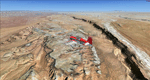
This scenery extends my Monument Valley scenery to the east. It covers the area between the San Juan River in the north down to Rock Point, AZ (49AZ). Most of the scenery lies on the Navajo Nation Reservation. It completes the southeastern corner of Utah and paves our way into Colorado.
High resolution versions of this scenery for FS9 and FSX (much sharper, but larger and multiple downloads) are available at www.blueskyscenery.com/CNY_South3West6.html . The screenies are taken from the high-res versions, so expect this version to be slightly more blurry. Thanks to Joop Mak for providing custom AFCADs that correct airport layouts so that they align with the photo-textures! They are available at www.blueskyscenery.com/AFCADs.html . YourDonation@Work: Dedicated to Olivier, Kevin and Ruben.
| Filename: | cny_south3_2010_lr.zip |
| License: | Freeware, limited distribution |
| Added: | 9th April 2010, 21:57:41 |
| Downloads: | 1,343 |
| Author: | Gottfried Razek, blueskyscenery.com |
| Size: | 90.99 MB |
© 2001-2025 AVSIM Online
All Rights Reserved