
Where Flight Simulation Enthusiasts Gather from Around the World!
AVSIM Library - Search Results

| Category: Flight Simulator 2004 - AFCAD Files | |
| OSDI Damascaus International, Syria |

|
File Description:
Googlyafcad A&F Data for Damascus International, based on Google Earth satellite
data.
Unfortunately, Microsoft have provided only limnited facilities at this important
airport in Flight Simulator 2004 and the absence of many taxiways present in the
real world can cause traffic to queue for long periods. This file will allow you
and your "AI" traffic to land, taxi, park and take off in a realistic manner.
| Filename: | OSDI_Damascaus_International_Syria.zip |
| License: | Freeware |
| Added: | 16th May 2008, 11:24:41 |
| Downloads: | 571 |
| Author: | John Hinson |
| Size: | 59.5 KB |
| Category: Flight Simulator 2004 - Aircraft Repaints, Textures and Modifications | |
| Oman Air Airbus A330-313X |
|
Images related to this file:
File Description:
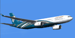
Oman Air is the national airline of Oman. Based in Muscat, it operates scheduled domestic and international passenger services, as well as regional air taxi and charter flights. Its main base is Muscat International Airport. This is one of the first Airbus A330-300 delivered on 2010 to this airline for international routes, registered as A40-DE. Repaint for the Project Open Sky A330-300 (model included).
| Filename: | Oman_Air_Airbus_A330313X.zip |
| License: | Freeware |
| Added: | 17th April 2010, 16:40:05 |
| Downloads: | 1,003 |
| Author: | Xudeva Irribarra, Project Opensky |
| Size: | 5.57 MB |
| Category: Flight Simulator 2004 - Scenery | |
| Puglia & Lucania Photoreal 2 - Brindisi |
|
File Description:
This photoreal scenery covers a great area of Puglia & Lucania, south Italy, from Barletta (northwest) to Potenza (west) to Policoro (south) to S.Maria di Leuca (southeast).
The complete scenery was divided into 6 parts: Lecce, Brindisi, Taranto, Bari, Matera, and Potenza. Matera was sub-divided into 2 parts to fit the max 100Mb file space.
This is part 2 - Brindisi, with the airport Brindisi Casale (LIBR).
| Filename: | Puglia__Lucania_Photoreal_2__Brindisi.zip |
| License: | Freeware |
| Added: | 15th April 2006, 06:25:26 |
| Downloads: | 10,766 |
| Author: | Lanzillotta Angelo |
| Size: | 78.54 MB |
| Category: Flight Simulator 2004 - Scenery | |
| EKCH Copenhagen (Kastrup) 1960 Ver 2 |
|
File Description:
FS2004 EKCH Copenhagen (Kastrup) 1960. This scenery represents Copenhagen Airport as it was in 1960, just after the new terminal (now Terminal 2) was opened. Runways and taxiways have been
adjusted to be like they were then. The old terminal was still in limited use, so I have incuded a few gates there as well. Version 2, with accurate coastline and other improvements. By Jens B. Kristensen
| Filename: | EKCH_Copenhagen_Kastrup_1960_Ver_2.zip |
| License: | Freeware |
| Added: | 9th April 2009, 16:25:34 |
| Downloads: | 2,684 |
| Author: | Jens B. Kristensen |
| Size: | 963.27 KB |
| Category: Flight Simulator 2004 - Scenery | |
| Copenhagen Kastrup East addon for Swedflight EKCH |
|
File Description:
Addon to Swedflights EKCH scenery. This scenery covers the east aera of Copenhagen Kastrup airport.
The scenery covers the area along the road “Kystvejen”. It starts beside the SAS hangars and
in this scenery it ends just before RWY30. All the buildings along this road are designed and
placed according to the locations, which fits to Swedflights scenery.
Requires Danish Base Scenery 1.0 by Lars Møllebjergs
| Filename: | Copenhagen_Kastrup_East_addon_for_Swedflight_EKCH.zip |
| License: | Freeware |
| Added: | 31st January 2006, 15:26:47 |
| Downloads: | 3,971 |
| Author: | Claus Hansen |
| Size: | 3.97 MB |
| Category: Flight Simulator 2004 - Scenery | |
| Webster OFL (KNUI) for UT/USA |
|
File Description:
Webster Field is an outlying airport realted to PAX Naval Air Test Center in Maryland. According to what I have read, they use the airport mainly to test unmanned aircraft.
In a support note I saw an image of this airfield in Ultimate Terrain showing its runways extending out into the water. So I fixed it. I couldn't find much more info on it other than that on www.AirNav.com, so I've just kept the default layout for the most part. I did have to rotate the runways a bit to match the satellite photo about 10 degrees for 14/32. I kept the runway labels, however as that is how they are listed in Airnav and show up in the satellite photo. If anyone has any further info I'd be happy to add to it.
This version is meant for use with Ultimate Terrain USA.
| Filename: | Webster_OFL_KNUI_for_UTUSA.zip |
| License: | Freeware |
| Added: | 23rd February 2006, 05:20:49 |
| Downloads: | 378 |
| Author: | Thomas Perry |
| Size: | 218.88 KB |
| Category: Flight Simulator 2004 - Scenery | |
| Siofok Kiliti-Sagvar (LHSK) 2.0 |
|
File Description:
Freeware Scenery of Siófok Kiliti-Ságvár airport. This airport is used for general aviation, at Lake Balaton, has grass runway. Only for Flight simulator 2004. Changes and addons for version 2.0: Correct AFCAD from map, correct city placement, with VTP2 polygons. Roads, railways, Rivers, bridges and coastline position is now correct. Added Docks, detailed landclass with VTP2 polygons. Every centimeter of the detailed area now fits the sattelite photo. This scenery itself has a large addition to the default LHSK, which only has a runway. This addon has a correct afcad with taxiways and apron. Also added the ILS and PAPI for runway 33. This scenery was made for an aerobatic event on the IVAO network, so an aerobatic box is also added above Lake Balaton. You can remove this box at anytime via the instructions. Hope you enjoy this scenery and will have fun with it.
| Filename: | Siofok_KilitiSagvar_LHSK_20.zip |
| License: | Freeware, limited distribution |
| Added: | 11th March 2006, 16:45:04 |
| Downloads: | 1,533 |
| Author: | David Zoltan |
| Size: | 571.88 KB |
| Category: Flight Simulator 2004 - Scenery | |
| Petaluma , California (O69) Scenery |
|
File Description:
This is a scenery upgrade for Petaluma Airport, California (O69). This is part Five of a series of small airstrip and minor airfield scenery enhancements which are based on real world data from Google Earth.
This is a more complex scenery than previous ones. You can see from the Google earth image that a golf course runs alongside the airport (appropriately called the Rabbit Run!). I have tried to include this with a golf course landclass polygon, also the airfield base seems mainly a red soil and this is reflected in the airbase poly. Built using EZ_Scenery, Lee Swordy's AFCAD and SBuilder. You must have rwy12 and EZ scenery libraries installed for the buildings to show. Both libraries of objects are free;
EZ Library is available from this URL http://www.abacuspub.com/pub/AbacusEZLibraries.exe
rwy12 from Avsim and additional EZ Custom libraries from Avsim. Search under Scenery design.
| Filename: | Petaluma__California_O69_Scenery.zip |
| License: | Freeware |
| Added: | 23rd March 2006, 23:09:07 |
| Downloads: | 719 |
| Author: | Kim Gowney |
| Size: | 629.87 KB |
| Category: Flight Simulator 2004 - AFCAD Files | |
| Syamsudin Noor, Banjarmarsin, Indonesia (WAOO/BDJ) |
|
File Description:
Googlyafcad A&F Data file for WRBB Banjarmasin/Syamsudin Noor/Ulin in Kalimantan, Indonesia based on Google Earth satellite data. Unfortunately, Microsoft have provided very limited facilities at this important Indonesian domestic airport, served by over twenty-five flights a day by Adam Air, Airfast, Bali International, Batavia Air, Bouraq, Garuda, Indonesia Air Transport, Lion Airlines, Mandala Airlines, Merpati Nusentara
and Sriwijaya Air jets and smaller craft. This upgrade redresses the subject by supplementing the GA parking with gates so that you, and your "AI" traffic can land, taxi, park and take off realistically. Whilst this file improves the layout of the airport, it is not a full scenery upgrade and does not attempt correct building locations, landclass, taxiway signs or those stupid over-sized filling stations that Microsoft loves to put in annoying places. Regrettably the satellite data currently available is not of sufficient quality to do so.
| Filename: | Syamsudin_Noor_Banjarmarsin_Indonesia_WAOOBDJ.zip |
| License: | Freeware |
| Added: | 17th March 2007, 11:06:39 |
| Downloads: | 1,075 |
| Author: | John Hinson |
| Size: | 59.7 KB |
| Category: Flight Simulator 2004 - Scenery | |
| Mehrabad Ver 1.0 (Tehran-Iran) |
|
Images related to this file:
File Description:

.::PERSIAN-SIM::. This package contains a simple scenery of Mehrabad Intl Airport OIII (Tehran-IRAN) and its buildings, aprons and hangars. The aprons contain all civil ,military and others. The AFCAD file of the airport is designed and updated exactly using the latest changes of Mehrabad which includes the following changes: 1.The complete change of Taxiway names and Taxiway signs; 2.Additional west parking space with 10 parking positions (APRON 4); 3.TWY 13 has been eliminated; 4.Apron names have been changed; 5.The position of Fire Fighting Station is changed (a new station is built); 6.All Parking positions are changed in names and headings. This version of Mehrabad is fully freeware and is available only from PERSIAN-SIM and AVSIM Library. The PROFESSIONAL version of Mehrabad (Payware), including the realistic scenery, buildings, static aircrafts, and realistic dynamic scenery, will be available soon on www.PERSIAN-SIM.com.
| Filename: | Mehrabad_Ver_10_TehranIran.zip |
| License: | Freeware, limited distribution |
| Added: | 3rd November 2010, 23:26:41 |
| Downloads: | 1,651 |
| Author: | PERSIAN-SIM ::: Behnam Zamani |
| Size: | 5.12 MB |


© 2001-2026 AVSIM Online
All Rights Reserved
Privacy Policy |