
Where Flight Simulation Enthusiasts Gather from Around the World!
AVSIM Library - Search Results

| Category: Flight Simulator 2004 - AFCAD Files | |
| KRUQ - Rowan Co - Salisbury, North Carolina |

|
File Description:
AFCAD for Rowan County Airport (KRUQ), Salisbury, North Carolina. This is primarily a general aviation airport, roughly 40nm southwest of Greensboro (KGSO). I placed parking with the aid of satellite imagery, as well as some modifications to the basic layout (including adding the 13 helipads on the west ramp, which are Army National Guard, I believe).
| Filename: | KRUQ__Rowan_Co__Salisbury_North_Carolina.zip |
| License: | Freeware |
| Added: | 14th October 2005, 17:57:45 |
| Downloads: | 377 |
| Author: | Ross Aldrich |
| Size: | 37.12 KB |
| Category: Flight Simulator 2004 - AFCAD Files | |
| KVUJ - Stanly County Airport, Albemarle, North Carolina |
|
File Description:
AFCAD for KVUJ - Stanly County Airport in Albemarle, North Carolina. This is a general aviation Airport roughly 40nm northeast of Charlotte (KCLT). There are over 45 parking spaces placed here (including the ramp used by National Guard C-130s), using Satellite Imagery for guidance, and I made some minor corrections to the general layout of the ramp. Please enjoy!
| Filename: | KVUJ__Stanly_County_Airport_Albemarle_North_Caroli.zip |
| License: | Freeware |
| Added: | 17th October 2005, 01:26:49 |
| Downloads: | 411 |
| Author: | Ross Aldrich |
| Size: | 4.08 KB |
| Category: Flight Simulator 2004 - Scenery | |
| Boscomantico LIPN |
|
File Description:
Boscomantico LIPN is a small civil airport near Verona, Italy.
Here there is a small AeroClub, and a Parachute's School.
The airport lay-out is realistic;the positions of hangars and other buildings are realistic;hangars and building, and other objects are from RWN12 group, and are not realistic. You need to have installed properly RWY12 static object library.
| Filename: | Boscomantico_LIPN.zip |
| License: | Freeware, limited distribution |
| Added: | 29th October 2005, 22:11:15 |
| Downloads: | 2,196 |
| Author: | Luciano Franchini, RWY12 |
| Size: | 164.54 KB |
| Category: Flight Simulator 2004 - Utilities | |
| QuickGOTO version 1.2 for FS2004 |
|
File Description:
Keeps a database of the most frequently used departure locations (gates, parkings or runways), so it will be no longer necessary to search for the airport through Flight simulator Airport/Facilities directory and to move the aircraft to the correct departure point each time: just select the desired location from QuickGOTO and the airplane will be instantly moved there.
| Filename: | QuickGOTO_version_12_for_FS2004.zip |
| License: | Shareware, limited functionality |
| Added: | 12th March 2007, 18:15:52 |
| Downloads: | 1,203 |
| Author: | Luciano Napolitano |
| Size: | 684.68 KB |
| Category: Flight Simulator 2004 - AFCAD Files | |
| Nagasaki (RJFU) |
|
File Description:
The first time I came to this airport, I noticed that there was no connection between the two parts of Nagasaki Airport. So, I decided to get out my "virtual heavy equipment" and pave myself a new taxiway. There is now, with this file, a greatly extended Taxiway T2 that runs along the land bridge between the two sections.
| Filename: | Nagasaki_RJFU.zip |
| License: | Freeware |
| Added: | 17th June 2007, 08:47:43 |
| Downloads: | 497 |
| Author: | Tom Clayton Jr |
| Size: | 68.13 KB |
| Category: Flight Simulator 2004 - Scenery | |
| New Plymouth Airport, New Zealand. NZNP. V-2 with PHOTOREAL buildings. |
|
File Description:
Welcome to New Plymouth, a medium sized domestic airport in the Taranaki district, on the central west coast of the North Island of New Zealand.
This new "Version-2" uses PHOTOREAL buildings for the airport,(textures included), instead of object library items, for most buildings. Some EZ Scenery libraries are still required (see INSTALL instructions for details).
| Filename: | New_Plymouth_Airport_New_Zealand__NZNP__V2_with_PH.zip |
| License: | Freeware, limited distribution |
| Added: | 11th March 2008, 08:09:49 |
| Downloads: | 1,926 |
| Author: | Lawrie Roache / Mike Andrews |
| Size: | 2.59 MB |
| Category: Flight Simulator 2004 - AFCAD Files | |
| Osubi Airstrip |
|
File Description:
Osubi Airstrip, also known as Warri Airport ,is located at Osubi, a town near Warri in Delta State, Nigeria.
Osubi is not included in the default FS9, but it is a fast growing airport in Nigeria.
There is no ICAO identifier for Osubi so I use DNSU which is also used by a few airliners in the real world.
| Filename: | Osubi_Airstrip.zip |
| License: | Freeware |
| Added: | 25th March 2009, 17:31:05 |
| Downloads: | 332 |
| Author: | Menno van den Boogaard |
| Size: | 308.15 KB |
| Category: Flight Simulator 2004 - Scenery | |
| St Charles County (Smartt) |
|
File Description:
FS2004 Scenery - St Charles County (Smartt Field) KSET is a public owned airport lovated in St Charles, MO, USA. The airport has two asphalt runways 9/27 running 2000 ft and 18/36 running 3800 ft. This is a companion scenery for my recently released St Charles Municipal (3sq_v1.zip). Created with Instant Scenery. By John B. Loney, Jr.
| Filename: | St_Charles_County_Smartt.zip |
| License: | Freeware, limited distribution |
| Added: | 3rd April 2009, 18:57:54 |
| Downloads: | 388 |
| Author: | John B. Loney, Jr. |
| Size: | 6.4 MB |
| Category: Flight Simulator 2004 - AI Flight Plans | |
| Aeropelican Air Services (Winter 2009) |
|
Images related to this file:
File Description:

Aeropelican Air Services is a small regional airline based in Newcastle, New South Wales, Australia and operating several BAe Jetstream-32's. Its main base is Newcastle Airport (Williamtown), with a hub at Sydney Airport. This winter 2009-2010 flightplan includes 72 weekly flights, tested (CH-Aviation, Flightstats, Amadeus) and fully functional! Developed using MRAI Compiler.
| Filename: | Aeropelican_Air_Services_Winter_2009.zip |
| License: | Freeware |
| Added: | 23rd January 2010, 11:21:38 |
| Downloads: | 458 |
| Author: | Vuqar Quliyev (SIMurq-AI) |
| Size: | 4.87 KB |
| Category: Flight Simulator 2004 - Scenery | |
| Enna and Madonie mountains, Sicily, Italy, Photo Real |
|
Images related to this file:
File Description:
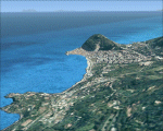
The photoreal scenery covers a great area of Sicily around the city of Enna and to the mountains of the Madonies. The Photo Real Scenery is wide for around 3200 squared Kms. The airport of Palermo (ICAO code LICJ) is found near to the scenery (see map). Otherwise the airport of Catania (ICAO code LICC) can be used.
| Filename: | Enna_and_Madonie_mountains_Sicily_Italy_Photo_Real.zip |
| License: | Freeware |
| Added: | 31st May 2010, 17:39:47 |
| Downloads: | 9,470 |
| Author: | Fulvio Mazzokan |
| Size: | 94.49 MB |


© 2001-2026 AVSIM Online
All Rights Reserved
Privacy Policy |