
Where Flight Simulation Enthusiasts Gather from Around the World!
AVSIM Library - Search Results

| Category: Flight Simulator 2004 - Scenery | |
| PGUA - Andersen AFB, Guam (V3) **UPDATE** |

|
Images related to this file:
File Description:

FS2004 scenery for Andersen AFB on the island of Guam. Andersen AFB started life as one of many airfields constructed in 1944 for the final aerial assault on the Japanese islands. Originally designed as a long range bomber base, Andersen has grown in scale to keep pace with the newest U.S. Air Force ships. Andersen remained busy during the Korean and Vietnamese conflicts hosting the 19th Bomb Wing as well as various SAC units for combat, refueling, and logistical/material support. The base is hosted by the 36th Wing and provides support services for all visiting and transient aircraft from numerous allied nations. This scenery contains all-new custom objects for Andersen AFB as well as photo-realistic ground cover for the airfield. MY SINCERE APOLOGIES TO ALL WHO HAVE PREVIOUSLY DOWNLOADED THIS SCENERY. PLEASE DELETE ANY EXISTING INSTALLATION AND REPLACE WITH THIS FINAL VERSION 3.
| Filename: | PGUA__Andersen_AFB_Guam_V3_UPDATE.zip |
| License: | Freeware, limited distribution |
| Added: | 27th April 2013, 22:29:34 |
| Downloads: | 2,318 |
| Author: | John Stinstrom |
| Size: | 2.58 MB |
| Category: Flight Simulator 2004 - Scenery | |
| Iles de la Madeleine CYGR in Quebec Canada |
|
Images related to this file:
File Description:
The Iles de la Madeleine are a group of spit islands linked by bridges in the Gulf of St Lawrence. They are east of New Brunswick, north of Cape Breton Island, west of the Island of Newfoundland, and south of the mainland coast of Quebec. On a southwest to northeast axis they are 40 miles in length and the airport CYGR is pretty much at the midpoint of the southern line of islands. Take a look at the overhead from FS9 to see what I mean. CYGR has two runways, one is aligned 08-26 and is just under 4,400 feet long and 150 feet wide with lighting and PAPI at both ends. The second is aligned 16-34 and is 3,600 feet long and 150 feet wide, without lights or PAPI. Both are asphalt. The apron is not huge, and a newish (in 2010) hangar was built with separate access to the 16-34 runway. There are daily flights by Air Canada and Pascan Aviation included in the AI. The AI also includes some boats and a ferry, and I first used these with my Dutch Harbor scenery, so if you have that already.... This scenery also includes Cindy Hook, a small boat harbour just 2 miles southwest of the airport, and the larger harbour at Cap aux Meules a further 3 miles away that accommodates the daily ferry trips, along with fishing boats etc. Also included here is a further addition to the Homer PAHO scenery in the shape of a boat that is included in the Homer Spit harbour. Just add the contents of the scenery folder to the Homer scenery folder of your Homer installation, and the texture folder contents to the Homer texture folder. This is hopefully the last PAHO addition, and again apologies. If you find an error email me please, and note that my email address has been changed to rogwens at Gmail dot com.
| Filename: | Iles_de_la_Madeleine_CYGR_in_Quebec_Canada.zip |
| License: | Freeware, limited distribution |
| Added: | 28th July 2021, 17:02:18 |
| Downloads: | 189 |
| Author: | Roger Wensley |
| Size: | 26.7 MB |
| Category: Flight Simulator 2004 - Aircraft Repaints, Textures and Modifications | |
| NAC de Havilland DH-114 Heron 1B |
|
Images related to this file:
File Description: In 1957 they were written from use. One Heron was sold to the UK but sadly suffered a fatal crash on delivery. The other three, including ZK-BBM, were stored and in 1960 sold to Fiji Airways (later Air Pacific). In November 1975 Rotorua-based Air North bought ZK-BBM from Air Pacific. Already in 1978 she made her final landing and was stored for years at Ardmore Airfield. Classic Flyers NZ, based at Tauranga Airport acquired the Heron in March 1989. Since then she has been restored for static display at the Classic Flyers Museum.
You will need the DH-114 package available at Classic British Flightsim.
New Zealand National Airways Corporation (NAC) was the first operator to receive the DH-114. From 1952 till 1957 NAC flew with four Herons 1B's, which were acquired to serve those airfields which could not take NAC's standard airliner of those days, the Douglas DC-3. The Herons primarily flew across Cook Strait (Rongotai-Blenheim-Nelson) and later also to Hamilton and Rotorua. Since many modifications were required for this new airliner, the Herons proved too costly.
| Filename: | NAC_de_Havilland_DH114_Heron_1B.zip |
| License: | Freeware, limited distribution |
| Added: | 14th March 2014, 05:31:12 |
| Downloads: | 180 |
| Author: | Maarten Brouwer |
| Size: | 1.85 MB |
| Category: Flight Simulator 2004 - Aircraft Repaints, Textures and Modifications | |
| Air Berlin Boeing 737-800 |
|
Images related to this file:
File Description:
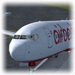
Empezamos septiembre e hice un nuevo repaint, esta vez del Boeing 737-800 de Air Berlin, esta es la segunda mayor linea aerea de Alemania, despues de Lufthansa, y la sexta mayor europea, Tiene su sede en la ciudad de Berlin, y opera vuelos cuasi-bajo costo entre 23 ciudades alemanas y ciudades europeas, destinos turisticos del Mediterraneo, las islas Canarias, Baleares y vuelos de largo recorrido a Las Americas, Asia y Africa. Modelo hecho por Project Open Sky, visiten mi blog en http://aerosimulaciones.blogspot.com/
Starting september and made a new repaint, the Air Berlin Boeing 737-800, Air Berlin is Germany's second largest airline, after Lufthansa, and Europe's sixth largest airline in terms of passengers. The airline operates an extensive network including holiday destinations in the Mediterranean region, the Canary Islands and North Africa and intercontinental destinations in Southeast Asia, the Caribbean and the Americas. Model by Project Open Sky, visit my blog in http://aerosimulaciones.blogspot.com/
| Filename: | Air_Berlin_Boeing_737800.zip |
| License: | Freeware |
| Added: | 7th September 2011, 22:15:10 |
| Downloads: | 862 |
| Author: | Juan Rodriguez / AeroSimulaciones |
| Size: | 7.87 MB |
| Category: Flight Simulator 2004 - AFCAD Files | |
| San Antonio International Airport (SAT/KSAT) |
|
File Description:
Accurate rendition of the KSAT airport. Includes accuarate gate numbering and locations for all airlines serving the airport as well as assigned cargo areas and parking for general aviation aircraft. This is my continuing series of doing airports that have been neglected by both MS and the community. Hopefully this will enhance flying into this airport for those of you that frequent it. Terminal space was mostly satisfactory even though not shaped correctly in some instances. Every gate, however, is present and correctly numbered and airlines assigned to the right gates based on the SAT airport website. American and Southwest seem to be the dominant carriers to this airport both offering extensive intra Texas service. I will be continuing to do mid sized aiports accross the US and then probably do some updates to my original Central America and Caribbean afcads. One for the St. Thomas airport in the US Virgin Islands should be up within 24 hours as well. Enjoy flying Texas!
| Filename: | San_Antonio_International_Airport_SATKSAT.zip |
| License: | Freeware |
| Added: | 29th June 2004, 19:35:00 |
| Downloads: | 2,368 |
| Author: | Jason Diaz |
| Size: | 146.83 KB |
| Category: Flight Simulator 2004 - Flight Plans | |
| 1945 - Harry Levy's Flight - Oban, Scotland to Dar-es-Salaam, Tanganyika in an RAF Sunderland MkV |
|
File Description:
At 1805 hours GMT on April 2nd. 1945 an RAF Short Sunderland Mk.V took off from the waters of the flying boat base near Oban, in Scotland. With the war in Europe nearly over, men and materiel were being transferred to the Far East, where Japan continued to defend its home islands with great ferocity and determination. The ten-man crew of the Sunderland included young Harry Levy, the navigator. Harry, now a resident of Canberra, Australia, was a Sergeant in the RAAF attached to an RAF aircrew and was being transferred to Dar-es-Salaam to join 259 Squadron, RAF. Their trip was to take them some 6000 nautical miles, over a period of 20 days (with a lot of that being spent in Gibraltar whilst engine repairs were carried out) and with more than 48 hours spent aloft. They departed Britain in the springtime and arrived in east Africa in autumn.
This is the FS9 recreation of that journey.
| Filename: | 1945__Harry_Levys_Flight__Oban_Scotland_to_DaresSa.zip |
| License: | Freeware |
| Added: | 24th February 2007, 08:18:44 |
| Downloads: | 1,708 |
| Author: | Bruce Kennewell, Brian Farrington and Leyland Spurr |
| Size: | 1.66 MB |
| Category: Flight Simulator 2004 - Scenery | |
| Quebec sceneries Enhancements |
|
File Description:
The files in this package contain enhanced sceneries of the province of Quebec, Canada (for FS2004 only). It's update for some islands of St.Lawrence river with much more new enhanced sceneries (see file list in Files_List.txt). Must be used with new terrain mesh for parts of the province of Quebec : QC09_2k4a.zip to QC09_2k4d.zip in AVSIM library.
Les fichiers contenus dans cette archive sont une mise � jour des sc�¨nes des �®les du fleuve Saint-Laurent avec un ajout important de nouvelles sc�¨nes. Vous en trouverez la liste compl�¨te dans le fichier �«Liste_fichiers.txt�». Pour ces sc�¨nes, l'utilisation du nouveau mesh du Qu�©bec pour FS2004 est indispensable. Vous les trouverez dans la biblioth�¨que d'AVSIM. Ils sont archiv�©s en quatre (4) parties : QC09_2k4a.zip � QC09_2k4d.zip.
| Filename: | Quebec_sceneries_Enhancements.zip |
| License: | Freeware, limited distribution |
| Added: | 1st November 2009, 06:48:12 |
| Downloads: | 4,960 |
| Author: | Gilles Gauthier |
| Size: | 4.15 MB |
| Category: Flight Simulator 2004 - Scenery | |
| Margarita Island (SVMG) |
|
File Description:
This is the latest scenery file for Margarita Island (SVMG) - the seventh base of Margarita Air Club.
Margarita Air Club is a virtual flying club based in the Caribbean that beleives that flying on the simulator should be FUN, not a chore. If you like what you see, please visit our website at http://www.margaritaair.com.
DESCRIPTION:
This file is intended to COMPLETELY replace the older versions of SVMG (AVSIM old file name 'svmg.zip'). This file, written in xml language and compiled using the new FS2004 SDK's should be compatible with all near-future versions of MSFS (or at least thats what they promise - LOL).
Once installed, you will see the Margarita Air Club ramp at Del Caribe Airport, and all the TMAC buildings.
AI Aircraft traffic has also been added to the airport. Planes in company colors will be performing T+G's and scheduled cargo runs to some of the neighboring islands several times per day.
| Filename: | Margarita_Island_SVMG.zip |
| License: | Freeware, limited distribution |
| Added: | 27th April 2006, 01:54:21 |
| Downloads: | 4,071 |
| Author: | Todd Lucas |
| Size: | 2.46 MB |
| Category: Flight Simulator 2004 - Scenery | |
| Sanikiluaq CYSK in Hudson Bay, Nunavut, Canada |
|
Images related to this file:
File Description:
Sanikiluaq is a village 740 or so inhabitants at N56 30, W79, which means in the southern part of Hudson Bay, close to James Bay. The village is at the north end of Flaherty Island, which is the largest of the Belcher Islands. You might fly there from La Grande Riviere in Quebec (200 miles SSE) or maybe from Moosonee in Ontario at the bottom of James Bay (350 miles SSW). Sanikiluaq village does not feature in FS9, so the first thing to do was to add it; it is the right shape and with around the right number of houses on the right streets but as I wasn't going to model 100+ individual houses just think of it as a hand-made auto-generated village. I also had to move the airfield over beside the river, so there is a DELETE file and a GRASS file and a ROADS file, as well as an AFCAD for AI and a scenery file. And AI for a visiting Air Inuit plane.
| Filename: | Sanikiluaq_CYSK_in_Hudson_Bay_Nunavut_Canada.zip |
| License: | Freeware, limited distribution |
| Added: | 11th October 2010, 23:15:41 |
| Downloads: | 516 |
| Author: | Roger Wensley |
| Size: | 2.21 MB |
| Category: Flight Simulator 2004 - Scenery | |
| Alaska South Slope 4; Selawik PASK |
|
Images related to this file:
File Description:
There are four main northwestern Alaska towns which are serviced by Alaska Airlines, and from which local flights spread out. The northernmost is Barrow. Southwest of Barrow is Kotzebue, then Nome, and the furthest south is Bethel. This series is for the flights from and around Kotzebue, mostly on the South Slope of the Brooks Range of mountains. There will be further additions. Selawik is a village (population now around 760) around 75 miles east of Kotzebue on three of the delta islands of the Selawik River where it flows into Selawik Lake. The delta forms part of the Selawik National Wildlife Refuge for migratory birds. The airfield is just next to the village, with two runways, 3,450 feet of lit gravel aligned 03-21 and 3,100 feet of gravel aligned 09-27. There are scheduled flights by Era (now renamed Ravn) and by Bering Air, both of them originating in Kotzebue and routing east to Noorvik, Kiana, Selawik, etc, and then back again. The AI includes these flights along with Everts Air and GA.
| Filename: | Alaska_South_Slope_4_Selawik_PASK.zip |
| License: | Freeware, limited distribution |
| Added: | 9th October 2016, 04:17:52 |
| Downloads: | 214 |
| Author: | Roger Wensley |
| Size: | 4.34 MB |


© 2001-2026 AVSIM Online
All Rights Reserved
Privacy Policy |