
Where Flight Simulation Enthusiasts Gather from Around the World!
AVSIM Library - Search Results

| Category: Flight Simulator 2004 - Aircraft Repaints, Textures and Modifications | |
| LAPA Namc YS-11 Combi (Green) |

|
File Description:
LJ in LAPA green livery.When in September 1979 Austral ceased operations with the Namcs, LAPA (Lineas Aereas Privadas Argentinas) an emergent commuter airline, bought the three planes and obtained the governmental license to exploit the forsaken routes left by Austral. With a new livery, and an agressive advertising campaign, the Namcs based at SABE, begun flights to Gral. Pico, Gral. Roca, La Plata, Mar del Plata, Necochea and Pehuajo. Despite a promising beginning, such routes were not profitable at the end, and the planes flew with a coefficient of occupation of only 21%, too low to keep the Namcs on the air. LAPA then, decided to halt the YS-11 and to replace them with the smaller Shorts 330. By the end of 1981, the Namcs were made available to the market, and bought by Mid-Pacific Air, concluding fourteen years of presence of the Namcs in Argentina. Included in this file there's a version of the YS-11 Combi fitted with the external Apu kit, done by Esa Kaihlanen of the AFG team. Textures only for the AFG's Namc YS-11 V2.7 Combi Configuration (ys-11combi.zip).
| Filename: | LAPA_Namc_YS11_Combi_Green.zip |
| License: | Freeware |
| Added: | 6th April 2007, 09:59:03 |
| Downloads: | 430 |
| Author: | AFG / Damian Radice |
| Size: | 9.26 MB |
| Category: Flight Simulator 2004 - Aircraft Repaints, Textures and Modifications | |
| LAPA Namc YS-11 Combi (Red) |
|
File Description:
India India in LAPA red livery.When in September 1979 Austral ceased operations with the Namcs, LAPA (Lineas Aereas Privadas Argentinas) an emergent commuter airline, bought the three planes and obtained the governmental license to exploit the forsaken routes left by Austral. With a new livery, and an agressive advertising campaign, the Namcs based at SABE, begun flights to Gral. Pico, Gral. Roca, La Plata, Mar del Plata, Necochea and Pehuajo. Despite a promising beginning, such routes were not profitable at the end, and the planes flew with a coefficient of occupation of only 21%, too low to keep the Namcs on the air. LAPA then, decided to halt the YS-11 and to replace them with the smaller Shorts 330. By the end of 1981, the Namcs were made available to the market, and bought by Mid-Pacific Air, concluding fourteen years of presence of the Namcs in Argentina. Included in this file there's a version of the YS-11 Combi fitted with the external Apu kit, done by Esa Kaihlanen of the AFG team. Textures only for the AFG's Namc YS-11 V2.7 Combi Configuration (ys-11combi.zip).
| Filename: | LAPA_Namc_YS11_Combi_Red.zip |
| License: | Freeware |
| Added: | 6th April 2007, 10:00:50 |
| Downloads: | 401 |
| Author: | AFG / Damian Radice |
| Size: | 9.22 MB |
| Category: Flight Simulator 2004 - Scenery | |
| Mackenzie CYZY in British Columbia, Canada |
|
Images related to this file:
File Description:
Mackenzie is around 120 miles west of Peace River and the BC/Alberta border, at the southern end of Williston Lake. The lake is 135 miles long and the population of the town is about 3,500; those figures illustrate typical Canada, a huge area enjoyed by the few. The main occupations relate to timber and mining in some form, plus tourism (in particular winter sports tourism). The airport is 2 miles southwest of the town, with no regular scheduled flights but it is not unusual to find Central Mountain Air there delivering either charter passengers or freight. The single runway is aligned 16-34 and 100 feet wide lit asphalt that is just over 5,000 feet long, with (in 2010 or so) an additional 1,500 feet of gravel. There is PAPI at both ends of the asphalt. The largest operation based at the airfield is a helicopter company, at the northern end of the apron. There is a "mandatory frequency" of 123.5 which is a Canadian invention; you MUST have a radio. There is no control tower at the actual airfield, and if or when there is no response from further afield then you announce your intentions etc. In FS9 there is no way to "switch off or on" the monitoring of a MF radio frequency so you will find that this one is always silent.
| Filename: | Mackenzie_CYZY_in_British_Columbia_Canada.zip |
| License: | Freeware, limited distribution |
| Added: | 27th December 2018, 20:19:05 |
| Downloads: | 133 |
| Author: | Roger Wensley |
| Size: | 19.81 MB |
| Category: Flight Simulator 2004 - AFCAD Files | |
| Southwestern British Columbia Airport Corrections |
|
File Description:
As shorelines, water bodies, roads, railways and other features become more accurate in addon scenery, inaccuracies in airport placement become apparent. Although Microsoft did an excellent job of using published data to place airports, the published information is not always accurate. Some airports in the area of interest were misplaced by as much as 850m, thus conflicting with water and/or roadways. This release corrects Canadian airports in South-western British Columbia, in LOD5 cell 15x14 (915140). This area covers a portion of Vancouver Island from Duncan to Victoria, and the BC Mainland as far east as Douglas Lake and north of Pemberton. In this region CAK3, CAL3, CBT6, CYHE, CYLY, and CYPS are corrected, and Bruce Ellison has kindly modified his CAM3 for inclusion; see separate readme document for details. All these airports have been activated for AI use. A few buildings that may conflict from roads have been removed from CYNJ. The unrealistically large flatten and airport polygon at CYYJ is reduced in size. Airport features that end up in the water have been removed from CYVR and the overly large flatten there reduced. Some Rwy12 goodies have been tossed in as well, but if these are not important to the user, it is not necessary to have Rwy12 installed. Ultimate Terrain or similar accurate hydrology and roads recommended. FSGenesis 38m mesh or other high quality terrain mesh recommended.
| Filename: | Southwestern_British_Columbia_Airport_Corrections.zip |
| License: | Check within download |
| Added: | 30th May 2005, 07:31:45 |
| Downloads: | 3,002 |
| Author: | Jon Patch, Bruce Ellison |
| Size: | 1.53 MB |
| Category: Flight Simulator 2004 - Aircraft Repaints, Textures and Modifications | |
| Air Canada Boeing 767-233 early 90's livery (C-GAUP) |
|
Images related to this file:
File Description:
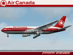
I was contacted some time back by some Canadian simmers looking for a rendition of an Air Canada Boeing 767-200 in the "Maple Leaf" 2 red cheat line livery of the early 1990's. I had been wanting a reason to repaint the Project Opensky Boeing 767 V4 model, so this was my chance. Sadly, Air Canada retired the last 767-200 from service in 2008. This particular airframe, the 5th 767 delivered to Air Canada, was retired around 2002.
This is a detailed repaint with custom textures. All windows are custom, hand-painted, 3D with window shades. The night textures are custom as well. The stewardess is a former Miss Canada, the interior exit signs are in French (SORTIE) and the pushback tug even bears the old Air Canada logos. The repainted textures in this package are 32-bit with no mipmaps for best clarity and quality. I hope you enjoy flying this wonderful aircraft as much as I did creating it. A special thanks to Lorne Jordan who suggested this repaint and supported me on getting it 'just right.' This is a complete install and contains all Project Opensky provided files current to Version 2004.8.0. The sound is from the default B737.
(This is a reupload of a work from April 2009 that was lost as a result of the AVSIM site compromise.)
| Filename: | Air_Canada_Boeing_767233_early_90s_livery_CGAUP.zip |
| License: | Freeware, limited distribution |
| Added: | 24th January 2010, 10:46:04 |
| Downloads: | 1,069 |
| Author: | Project Opensky, Jeffrey S. Bryner |
| Size: | 13.3 MB |
| Category: Flight Simulator 2004 - Scenery | |
| Kaltag KAL in Alaska |
|
Images related to this file:
File Description:
Kaltag is a small village on the west bank of the Yukon River, around 65 miles east of the coast at Unalakleet and about 40 miles south of where the river turns from north-south to east-west, east being upstream towards the distant Fairbanks. The population is just under 200 and living from fishing and the land. The airfield is close by and has a gravel runway aligned 21-3 and just under 5,000 feet long. Apart from the airfield itself, and it's buildings, this scenery modifies the local land class, adds village buildings while reducing the village size to reality, and creates a new airfield background. Kaltag is located on the edge of three different airlines coverage areas, and is served by Bering Air from the northwest, ERA from the southwest, and also by Wright Air from Fairbanks in the east. These are included in the AI.
A note here about my scenery making. This is post number 507 and there will not be many more to follow this as I am almost at the end of the photos I either took or found for scenery purposes. There is a limit to what can be located online and I have already been making use of the little there is; eg Unalakleet. So, if you are near an airport (preferably Canadian or Alaskan) and have a camera..... Let me know.
| Filename: | Kaltag_KAL_in_Alaska.zip |
| License: | Freeware, limited distribution |
| Added: | 20th August 2019, 19:04:35 |
| Downloads: | 103 |
| Author: | Roger Wensley |
| Size: | 3.57 MB |
| Category: Flight Simulator 2004 - Aircraft Repaints, Textures and Modifications | |
| FS2004/X PIA 747-367 AP-BFY "Ziarat" |
|
Images related to this file:
File Description:

Pakistan International Airlines (PIA) B747-367 Megatop Jumbo, AP-BFY, titled "Ziarat - The City of Flowers". This aircraft, delivered to PIA in 1999, was previously B-HOM for Cathay Pacific Airways. Contains photoreal tail, accurately placed titles and door surround repainted to match the actual airplane. Engines repainted with large yellow stickers on the left side of the casing to match the actual airplane. Being a later model 747, unlike PIA's other 747s, AP-BFY is one without the HF wingtip antennas and a different style wing root and the relevant model has been included. Repainted on the stunning Project Opensky 747v4 Advanced model, with all updates till March 2010. Contains ground service vehicles, stairs,tow truck, catering trucks, luggage loaders and containers painted in standard PIA colors. Luggage containers specially repainted to give a more realistic look. Registration of the aircraft painted on the bottom of the left wing, as on the real airplane. Panel updated to include utility gauge and tow truck gauge. Updated model and fde. Complete pack,requires no external downloads. Textures in high quality 32 bit format to conserve quality. NOT tested in FSX, but should work fine. Repaint by Irfan Khan & Ahmed Ahsen, exclusively from Virtual PIA (WWW.VPIA.ORG)
| Filename: | FS2004X_PIA_747367_APBFY_Ziarat.zip |
| License: | Freeware, limited distribution |
| Added: | 25th March 2010, 18:29:43 |
| Downloads: | 427 |
| Author: | Ahmed Ahsen / Irfan Khan(Virtual PIA/WWW.VPIA.ORG) |
| Size: | 16.42 MB |
| Category: Flight Simulator 2004 - Scenery | |
| Iloilo Airport ,Iloilo City, Philippines |
|
File Description:
Iloilo Airport is located in Iloilo City, Panay Island, Philippines. This local visayan airport is served by the following major domestic airlines: Philippine Airlines, Cebu Pacific and Air Philippines. This scenery features the most realistic replica of buildings located in the airport area such as the Main Terminal buildings, Control Tower, Crash and Fire Rescue Station, Philippine Air Force building, private hangars, shops, and commercial buildings including the SM City-Iloilo right in front of the airport area. SM City's parking area is generally filled with vehicles everyday that they are very visible at the ramp area of the airport at daytime and most especially visible glittering at nighttime.
This scenery also features the different commercial vessels serving Iloilo City such as WG&A Superferry, Sulpicio Lines, Negros Navigation, and Philippine Fastferry Corporation's Supercat and SeaAngels. These vessels are visible when flying from Iloilo to Bacolod City passing through the Guimaras Channel.
This scenery is designed with the combined efforts of Ver Walter Gulfan of Cebu City, Philippines and Manny Aquino of Surabaya, Indonesia. For suggestions or comments, please visit our Philippine Flightsimmers Group website at www.philskies.net or you may join our forum at www.philskies.net/forum.
RPVI AFCAD file included with aircrafts taking off at the middle of the runway!
| Filename: | Iloilo_Airport_Iloilo_City_Philippines.zip |
| License: | Freeware |
| Added: | 29th August 2003, 21:38:49 |
| Downloads: | 5,813 |
| Author: | Ver Walter Gulfan/Manny Aquino,Jr. |
| Size: | 5.83 MB |
| Category: Flight Simulator 2004 - Aircraft Repaints, Textures and Modifications | |
| Brooks Fuel Douglas DC-7C (N90251) |
|
Images related to this file:
File Description:

Textures for Tom Gibson's Douglas DC-7C - repainted by Manfred Meyer.
You need to download and install the latest Douglas DC-7C base pack with model, sound and panel from the website calclassic.com.
These textures depict N90251 (c/n 45367) originally delivered 1958 to Transports Aeriens Intercontinenteaux TAI as F-BIAQ, later to Madair Madagascar and from 1964 on with UTA for the French Air Force as 85-CB (F-ZBCB) and served for the french nuclear program in the Pacific. Later the DC-7 was equipped with large radomes on top and beneath the fuselage for tracking satellites and missiles. In December 1978 GCA bought the plane, registered it as N90251 and leased to Petroleum AT. From 1979 to 1982 the aircraft was stored and then in September 1986 bought by T & G. Aviation. For conversion to a spray plane, a 25 000 liter tank was brought into the cabin through the entry door in pieces and welded together inside. N90251 served as sprayer in Morocco and after returning to USA in 1995 Roger Brooks from Fairbanks bought the Seven and used it for transporting bulk fuel to remote settlements and mines in Alaska, using the former spray tank.
| Filename: | Brooks_Fuel_Douglas_DC7C_N90251.zip |
| License: | Freeware |
| Added: | 10th March 2015, 00:01:12 |
| Downloads: | 165 |
| Author: | Manfred Meyer |
| Size: | 6.48 MB |
| Category: Flight Simulator 2004 - Scenery | |
| FS9 Fort St John CYXJ in BC Canada |
|
File Description:
Fort St John is close to the border between British Columbia and Alberta, around 40 miles north-northwest of Dawson Creek. The airport was originally a Royal Canadian Air Force base, associated with the wartime construction of the Alaska Highway. The airfield was part of this construction effort and the wartime ferrying of planes to Russia. It is currently named "North Peace Regional Airport", or "North Peace Airport"; apparently there has been no final decision?
The date for this scenery is around 2006. I was given an old video tape cassette which was filmed on an uncertain date, but which had to be before the terminal building was renovated in 2007 and totally changed in appearance. The only way to view the video was to play it in the camera and watch it on a small screen. After I had completed everything except the buildings I started to view the video to establish the building appearances and within an hour or so the camera died. It was so old there was no way to repair it, so I then made some new buildings from memory of the video and what was available online. I also used some that I had already made for other scenery but which were similar. I may replace the terminal building that is in this version with a build of the new one, as I know this one is not a very accurate reproduction. The replacement, if I do it, will be towards the end of this year.
The AI included here is for GA, Air Canada Jazz, and two helicopter companies that were (and still are?) based there. One is at the western end of the apron and the other is at the eastern end but separated from the apron. To gain access to the taxiways and runways (so that all airport users follow the same procedures, for safety reasons) the eastern end helicopters just taxi across the grass. The helicopters are used for maintenance trips to the oil and gas fields in the surrounding area. My screenshots show Westjet at the terminal; this is because I have later Canadian AI installed, while the AI included here is only for the time around 2000 to 2010, when Westjet were not flying to Fort St John.
The airport is square in plan, with the apron running along the northern side and two runways forming diagonals. The two runways are 11-29 (6,882 feet long and 200 feet wide, with ILS at the 29 end and PAPI at the other) and 02-20 (6,684 feet long and 200 feet wide, and with PAPI at each end). The eastern side taxiway that runs north-south is not used. The western side taxiway is in use but only as a race track for cars.
Please email me if you find faults, such as a plane without textures.
| Filename: | FS9_Fort_St_John_CYXJ_in_BC_Canada.zip |
| License: | Freeware, limited distribution |
| Added: | 10th October 2022, 14:03:38 |
| Downloads: | 214 |
| Author: | Roger Wensley |
| Size: | 37.49 MB |


© 2001-2026 AVSIM Online
All Rights Reserved
Privacy Policy |