
Where Flight Simulation Enthusiasts Gather from Around the World!
AVSIM Library - Search Results

| Category: Flight Simulator 2004 - Gauges | |
| GPWS V3.3 |

|
File Description:
This freeware GroundProximityWarningSystem gauge for FS2004 can be added
to any aircraft that has retractable gear and flaps, and offers the
following features:
- Clickable switch, with Test/Inhibit function and warning light.
- 8 different warning modes, with all the usual aural warnings, like "Pullup",
"Sinkrate", "TerrainTerrain", "Windshear" and normal Altitude callouts.
- Fully customiseable per aircraft type, by just editing the gauge parameters
with Notepad.
See README for extensive description.
NEW in V3.3: new sound enable/disable handling, configurable
sound volumes, a new MasterWarningLight gauge (that enables you using the GPWS with
only a small gauge on the main panel window), and more.
For users of V2.0 (rcbgp-20.zip): see include file "Upgrade Notes" for upgrade and
detailled changes.
By Rob Barendregt.
| Filename: | GPWS__V33.zip |
| License: | Freeware, limited distribution |
| Added: | 4th July 2005, 01:33:23 |
| Downloads: | 31,161 |
| Author: | Rob Barendregt |
| Size: | 250.45 KB |
| Category: Flight Simulator 2004 - Scenery | |
| 1963 La Paz Bolivia El Alto Airport Scenery |
|
File Description:
El Alto International Airport (IATA: LPB, ICAO: SLLP) is an international airport located in El Alto, near the city of La Paz, Bolivia; it serves national and international air traffic. At an altitude of 13,325 ft (4,061 m), it is one of the highest international airports in the world. The facility served as a focus city for the former Lloyd Aereo Boliviano, Bolivia's national air carrier, and is a hub for Aerosur, the country's only significant private airline. This scenery takes El Alto back to circa 1963, and with AI traffic from www.calclassic.com will be populated with everything from C-46 meat haulers to C-124 Globemasters. GMAX terminal by Jaap de Baare, local landclass by Tom Gibson, and almost everything else by Harry Biard.
| Filename: | 1963_La_Paz_Bolivia_El_Alto_Airport_Scenery.zip |
| License: | Freeware, limited distribution |
| Added: | 2nd May 2008, 02:26:42 |
| Downloads: | 3,926 |
| Author: | Harry Biard, Jaap de Baare, and Tom Gibson |
| Size: | 270.99 KB |
| Category: Flight Simulator 2004 - Gauges | |
| FS2004 GPS Map View Gauge v3.0 |
|
File Description:
The ultimate gauge. The Map will show: Airports details (Runways ID's, length & ILS), VOR's and NDB's frequencies,
Intersections and waypoints, Airspaces, Approaches and flight routes. You can toggle the view
you require for your flight. Also you can zoom in/out to see the nearest airports, vor's and
ndb's. The map will indicate A/C heading flightplan title and waypoints ID's.
Version 3 includes more enhancements such as the ability to input the ICAO code or name of any airport and the map will
show all the frequencies of that airport including ATIS, ILS, AND COM. In addition, the map will show the active
runway designations, length and width.
You can also input ICAO code of any VOR/NDB and the map will show their frequencies.
There was a bug in v2.0, in which if you enter ( click on ENT )the ICAO code of an airport, you will lose the flight
plan loaded. Now you can go back to the flight plan and with the NEXT/PREV buttons you have the choice of where to start
your FP.
The gauge will show Flight Plan Title, originating and destination airports, active waypoint, waypoint index and FP
crusing altitude.
I addition, the gauge will show various useful information, such as, Runway IDs, lenght, width and approach magnetic heading,
Airport name, city, and type. NAV1/2 names, codes, distances and ETA's, ADF1/2 names and codes.
Finally, the gaugee will show other information, such as, magvar, indicated airspeed, mach, ground velocity, ambient
wind velocity and direction, bank angle , and a/c altitude ( radio height ).
All the information above and much more on a single gauge window.
| Filename: | FS2004_GPS_Map_View_Gauge_v30.zip |
| License: | Freeware, limited distribution |
| Added: | 14th September 2005, 14:19:46 |
| Downloads: | 10,848 |
| Author: | Talal Alhaj |
| Size: | 710.05 KB |
| Category: Flight Simulator 2004 - Aircraft Repaints, Textures and Modifications | |
| Royal Italian Air Force Lockeed P-38J |
|
File Description:
The Lockheed P-38 Lightning was one of the most prominent fighters throughout WWII in both major theaters of operation. P-38s scored some of the first victories in the Pacific Theater. In Europe, they often provided high-altitude long range escorts for bombers. A P-38 was captured by the Italians on 12th June 1943 after a mistaken landing in Capoterra airport (Cagliari, Sardinia). After a while, with 'Regia Aeronautica's insignas (Royal Italian Air Force), it was flown by Colonel Angelo Tondi in a fighter mission over Torvajanica (Rome), where a B-24 was shotted down. The aircraft was finally grounded due to the damages caused by Italian fuel to the tanks.Textures only in 'Regia Aeronautica' livery for payware 'Sky Unlimited Lockheed Aircraft P38 Vol.1'. Repaint by Manuele Villa.
| Filename: | Royal_Italian_Air_Force_Lockeed_P38J.zip |
| License: | Freeware |
| Added: | 6th November 2006, 10:49:19 |
| Downloads: | 259 |
| Author: | Manuele Villa |
| Size: | 2.88 MB |
| Category: Flight Simulator 2004 - Aircraft Repaints, Textures and Modifications | |
| USAAF B-24D "Kate Smith" 98th Bomb Group, 9th AAF |
|
File Description:
"Kate Smith" 42-40991 was a B-24D-120-CO which came off the production lines of Consolidated, San Diego. The art work depicts American Singer Kate Smith's theme song, "When the Moon Comes Over the Mountain". This ship was flown by the 1Lt James A Deeds to Ploesti on August 1, 1943. While taking part in the disasterous 98th BG attack on the Astra Romana-Phoenix Orion refinery complex, it took a direct hit in the cockpit area over the target at an estimated 250 ft of altitude. The aircraft caught fire in the bomb bay area and exploded mid-air. Miraculously, the copilot, 2Lt Clifton Foster was blown clear of the disintergrating aircraft and was able to open his parachute. Taken prisoner, he was the only survivor of the ten man crew.
| Filename: | USAAF_B24D__Kate_Smith___98th_Bomb_Group__9th_AAF.zip |
| License: | Freeware |
| Added: | 13th October 2008, 18:23:34 |
| Downloads: | 196 |
| Author: | Gary Horton |
| Size: | 12.82 MB |
| Category: Flight Simulator 2004 - Original Aircraft | |
| Air Asturias Airbus A320-214 Sharklet |
|
Images related to this file:
File Description:
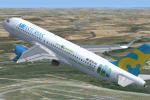
Air Asturias, a draft budget airline and tour operator established in late 2005 on the basis of the Principality of Asturias (Spain) and dissolved in January 2007. The company never have the necessary licenses to operate as an airline and marketed flight of the LTE company name. This is your registration EC-ISI. FS2004/Fsx Project Airbus A320-200, saved in Dtx5 format with 32 bits for more resolution, 2D/NoVC, based on the default A321 panel. Livery for Air Asturias (Spain) of Project Airbus model. Addons, Garrett Smith's FMC (requires FMC-1.ZIP), V-speeds (Jelair), Groundhandling (pushback) and altitude callouts. Ready to fly. For Fs2004 and FSX. I haven´t FS2004 / FS9 so if there is a problem with some addon apologize, please tell me. Project
| Filename: | Air_Asturias_Airbus_A320214_Sharklet.zip |
| License: | Freeware |
| Added: | 29th January 2015, 10:49:23 |
| Downloads: | 1,981 |
| Author: | Juan Villamor |
| Size: | 54.48 MB |
| Category: Flight Simulator 2004 - Original Aircraft | |
| Dassault-Mirage F-1 CZ |
|
File Description:
The Dassault-Mirage F-1 was developed to address the shortcomings of the Mirage III, especially the shortcomings in handling. The F-1 CZ is the fighter-striker version of the F-1. Two paint schemes are provided; the first is the camouflage version of 3 Squadron of the South African Air Force during the late 1970’s and the second the low visibility gray used by the same squadron during the 1990’s. This aircraft features full animation (control surfaces, spoilers, landing gear & canopy), a dynamic virtual cockpit, checklist and full lighting effects. A custom-designed photo-realistic panel (with xml-gauges) is also included. If you would like to fly a supersonic fighter, this it it – this jet can really reach Mach 1.2 at sea level and Mach 2.2 at high altitude.
| Filename: | DassaultMirage_F1_CZ.zip |
| License: | Freeware |
| Added: | 19th June 2004, 07:24:25 |
| Downloads: | 7,324 |
| Author: | Vasco Ferreira & Thinus Pretorius |
| Size: | 5.38 MB |
| Category: Flight Simulator 2004 - Original Aircraft | |
| Supermarine Spitfire Mk. IX |
|
File Description:
The Spitfire was developed continuously throughout World War II, through some 24 versions. A major revision of the original Spitfire was the Mk IX, a model quickly cobbled together to meet the challenge of the newly emerging Focke-
Wulf 190. The high-altitude version Mk IX was essentially a Mk V with a 1,710-hp Merlin 70 engine, capable of more than 400 mph. From 1942 to 1944 5,665 Mk IXs were built, and at war's end many were still in RAF service.
This is the airplane flown by Lt.-Col Robert (Bob) Rogers, commanding officer of Nr. 40 Squadron of the South African Air Force in Italy during 1944.
This model has full animation, full lighting effects and a realistic panel with accurate views in all directions.
| Filename: | Supermarine_Spitfire_Mk_IX.zip |
| License: | Freeware |
| Added: | 11th January 2004, 18:57:50 |
| Downloads: | 4,465 |
| Author: | Vasco Ferreira |
| Size: | 1.55 MB |
| Category: Flight Simulator 2004 - Flight Plans | |
| World Capital Tour |
|
File Description:
On this tour you will nearly visit all capitals in the world except for the capital or the country has no airport like Monaco.
The tour starts at Falklands and ends in New Zealand via South America, the Carribean, Central America, North America, Europe, Africa, Asia and Australia/Oceania. The tour is designed as a sightseeing tour, means the maximum distance is about 600 nm and you will fly at altitudes between 7000ft and 16000ft. Only at the Anden and Himalaya region the altitude will be higher.
The tour has approximately 290 legs and the total distance is 95400 nm.
The package includes the PLN files for all legs. Additionally there's an Excel-Sheet which you can use as a logbook and KLM files so you can display the tour on Google Earth.
| Filename: | World_Capital_Tour.zip |
| License: | Freeware |
| Added: | 5th January 2008, 22:10:59 |
| Downloads: | 1,428 |
| Author: | Wolfgang Schroeder |
| Size: | 1.41 MB |
| Category: Flight Simulator 2004 - Miscellaneous Files | |
| Quebec, Canada - Airports with ILS |
|
File Description:
First, a .PDF file ( requires the free software Adobe Acrobat Reader ) presenting 2 tables ( one in FRENCH and one in ENGLISH ) which list the airports in the province of Quebec, Canada that have at least one runway that offers the assistance of the Instrument Landing System ( ILS ) to pilots trying to land.
Informations such as runway(s) number, lenght and altitude, heading, NAV 1 radio frequency are provided.
Also a column that specifies which of the 3 ILS components are available : LOC, GP, DME.
Only airports with at least the LOC ( localiser ) AND GP ( glide path ) appear in this list. Unfortunatly the DME component ( distance measuring equipment) is rarely available at the runway level that is.
A second .PDF file (Acrobat) lists the airport scenery addons corresponding, when available, to the airports listed in the first file.
| Filename: | Quebec_Canada__Airports_with_ILS.zip |
| License: | Freeware |
| Added: | 21st June 2008, 22:21:28 |
| Downloads: | 337 |
| Author: | Marc Renaud |
| Size: | 145.9 KB |


© 2001-2026 AVSIM Online
All Rights Reserved
Privacy Policy |