
Where Flight Simulation Enthusiasts Gather from Around the World!
AVSIM Library - Search Results

| Category: Flight Simulator 2004 - Scenery | |
| EPGO Goraszka 2010 - The Airshow Challenge |

|
Images related to this file:
File Description:
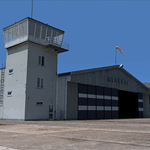
EPGO Goraszka 2010 - The Airshow Challenge is a freeware, extremely detailed scenery of a general aviation airport located 12nm (20km) south-east of Warsaw downtown and Warsaw Frederic Chopin International Airport, Poland. EPGO Goraszka airfield was built in 1994 and currently belongs to a General Aviation company, which offers aero-taxi flights, air transport and special flights (air photo, patrol) and airport services. The airport has a 800m-long runway and a lightened helipad, which can be used by helicopters of up to 5700kg weight. General Aviation's fleet includes Antonov AN-2, PZL-104 Wilga 80, Bell 407 and 427. Since 1996 the International Air Picnic Goraszka is organized every year by the "Polish Eagles" foundation created on initiative of Zbigniew Niemczycki.
The scenery is equipped with an automatic installer. Currently we support a safe, manual way of adding new sceneries to the Scenery Library in Flight Simulator. This is just one thing users need to do for themselves. Detailed instructions will be given during the installation process.
Scenery features:
-Compatible with FS2004 only
-Highest level of accuracy in geographic positioning, modeling and texturing
-Incredibly high quality photoreal textures of all airport buildings. Textures are based on over 300 real world -photographs made for this project.
-Hundreds of 3D objects like tents, exhibitions, airport buildings and surrounding buildings
-Life in the airport: people and cars will enhance your feelings
-AI traffic, animations and effects, designed specifically for FS2004
-Some buildings include interior (control tower)
-High quality aerial photos of the airport surroundings (5 seasons + night) with autogen and water mask
-Ultra high quality aerial photos of the airport (with seasons)
-Plain airport scenery with no airshow objects available too (details in the manual)
-Product includes manual and airport charts in PDF format
EPGO Goraszka 2010 - The Airshow Challenge scenery is compatible with almost every payware add-on, including Ultimate Terrain Eastern Europe and Warsaw Photo Scenery by Simdesign.
Scenery by Drzewiecki Design - www.drzewiecki-design.net
| Filename: | EPGO_Goraszka_2010__The_Airshow_Challenge.zip |
| License: | Freeware |
| Added: | 14th July 2010, 09:49:07 |
| Downloads: | 3,751 |
| Author: | Drzewiecki Design - Stanislaw Drzewiecki, Jakub Paczek |
| Size: | 132.03 MB |
| Category: Flight Simulator 2004 - Scenery | |
| Ría de Vigo (Bay of Vigo) |
|
File Description:
Comprehensive revision of the area surroinding the Bay of Vigo, near the Vigo Airport (LEVX, aprox. at 42º18'N 8º38'W), in Galicia, Spain, including a more accurate coastline, from the Ría de Aldán until Toralla Island, plus the San Simon Island and other minor islands, detailed piers in Vigo and Cangas, several beaches, and a lot of 3D VFR references (more than 180 macros added), such as buildings (the City Hall, the Hospital Xeral, the Balaídos Stadium, the Castro stronghold...), working lighthouses, several monuments and statues, some main streets redrawn, a new version of my Rande Bridge, now with collision detection and landable surface, and a handfull of eye-candies I can't even remember! -
Completa revisión da costa da Ría de Vigo, dende a Ría de Aldán ata pasada a Illa de Toralla, incluíndo, por suposto, á Illa de San Simón e outros pequenos illotes, praias (Samil, Nerga...), os peiraos de Cangas e de Vigo, dende o Areal ata Bouzas, unha morea de novas referencias visuais (máis de 180 macros), con edificios (o Concello, o Hospital Xeral, o estadio de Balaídos, o castelo do Castro, o lazareto de San Simón...), faros (nas Cíes e na costa...), algún que outro monumento, unha revisión do trazado dalgunhas das vías principais, unha nova versión da miña Ponte de Rande, con detección de colisións e superficie "aterrable", e moitas cousas máis que xa nin eu mesmo lembro. -
Completa revisión de la costa de la Ría de Vigo (Galicia, España, aprox. en 42º18'N 8º38'O), desde la Ría de Aldán hasta pasada la Isla de Toralla, incluyendo la Isla de San Simón y otros pequeños islotes, playas (Samil, Nerga...), los muelles de Cangas y de Vigo, desde el Areal hasta Bouzas, un montón de nuevas referencias visuales (más de 180 macros), con edificios (el Ayuntamiento, el Hospital Xeral, el estadio de Balaídos, el castillo del Castro, el lazareto de San Simón...), faros (en las Cíes y en la costa...), algún que otro monumento, una revisión del trazado de algunas de las vías principales, una nueva versión de mi Puente de Rande, con detección de colisiones y superficie "aterrizable", y muchas cosas más de las que ni yo mismo me acuerdo.
| Filename: | Ra_de_Vigo_Bay_of_Vigo.zip |
| License: | Freeware |
| Added: | 16th May 2004, 23:48:38 |
| Downloads: | 4,478 |
| Author: | Rubén Castiñeiras |
| Size: | 366.85 KB |
| Category: Flight Simulator 2004 - Scenery | |
| Cameri and Turbigo sceneries (rev. 3) - north Italy |
|
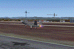
Images related to this file:
File Description:
The following files are required by this file:
http://library.avsim.net/esearch.php?DLID=163723&UploadID=&Name=&FileName=&Author=&CatID=root
http://library.avsim.net/esearch.php?DLID=186350&UploadID=&Name=&FileName=&Author=&CatID=root
This scenery includes a global review of the previous Sceneries of Cameri Military airport (rev.2 Oct 2011), Cameri Museum (rev. 2 Oct 2011), Cameri Babini (rev. 2 oct 2011), Turbigo power station (rev. 2 Sep 2011 and update rev. 2.1 Oct 2014). All the above ARE NOW INCLUDED in this new unique scenery. Contents: Terrain in new version photo-realistic multi-seasons/night; adapted to Western Europe special elevation meshes; cover area of over 120 sqkm from Bellinzago-Oleggio (NW) to Magnago-Bienate (NE), from Novara (SW) to Cuggiono-Inveruno (SE); all the terrain has been restorated with 3D buildings, either through autogen that with specific dedicated objects (by GMax) and with significant addition of library objects ("dva51" and other existings). This scenery (located on the final approach to the Milan Malpensa international airport) includes the Cameri's Mil Airport with the Babini closed Army area and the planes of the Historical Museum of the airport; it is also included the thermoelectric power station of Turbigo. All the buildings are placed to recreate cities and villages covered in the photo-realistic terrain, including Bellinzago, Bienate, Buscate, Caltignaga, Cameri, Castano Primo, Castelletto Ticino, Cuggiono, Galliate, Inveruno, Magnago, Malvaglio, Nibbia, Novara, Oleggio, Pernate, Robecchetto, Romentino, Sant'Anna, San Pietro Mosezzo, Turbigo , Vanzaghello, and the covered Turin-Milan highway.
Details of the new buildings for the care and maintenance to F35 completely recreated, as obtainable from the current satellite view.
It REQUIRES the use of the following, to be downloaded separately :
- the libraries dva51 - the system of vegetations TreePlanter - the West Europe Meshes of Daniele Lanfranchi. See the Readme file. Enjoy!
Videos available here:
https://dl.dropboxusercontent.com/u/38829151/FS9/Cameri_Turbigo_v3%20shots.WMV
http://youtu.be/yVI2KeJKS5o
http://youtu.be/oKa0e_5kxIk
| Filename: | Cameri_and_Turbigo_sceneries_rev_3__north_Italy.zip |
| License: | Freeware |
| Added: | 21st January 2015, 21:32:36 |
| Downloads: | 990 |
| Author: | Aldo Della Vedova, Daniele Lanfranchi and Gian Mario Verga |
| Size: | 103.7 MB |
© 2001-2026 AVSIM Online
All Rights Reserved
Privacy Policy |