
Where Flight Simulation Enthusiasts Gather from Around the World!
AVSIM Library - Search Results

| Category: Flight Simulator X - Scenery | |
| Trois-Rivieres CYRQ |

|
Images related to this file:
File Description:
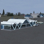
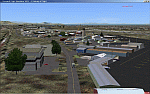
Trois-Rivieres Airport (CYRQ) is located near the city of Trois-Rivieres, Quebec, Canada, midway between Quebec and Montreal on the north shore of the St-Lawrence river. It has a large maintenance and painting shop to service aircrafts the class of B737, A320 or equivalent size. This GA airport had its runway (05-23) extended to 9000' so that is can now receive and accomodate the B767.
This scenery developed in GMax, is an exact and realistic representation of the airport. It features 28 detailed buildings including its unique terminal, custom vehicles and much more. From the airport, you can see the flashing strobe lights of the 1200 feet tower located 8 miles NE of the airport; cleary visible night and day which is a very good landmark coming in to land. Another nice landmark is the nearby beautiful Laviolette bridge (if installed from the same author). Take your favorite GA aircraft there for a sightseeing tour or a fishing trip a short distance north of Trois-Rivieres, your executive jet for a business meeting or service your airline jet in the maintenance bays. It is a nice airport to see.
| Filename: | TroisRivieres_CYRQ.zip |
| License: | Freeware |
| Added: | 26th November 2009, 02:43:30 |
| Downloads: | 7,252 |
| Author: | Gilles Boily |
| Size: | 6.9 MB |
| Category: Flight Simulator 2004 - Scenery | |
| Camden Field in Trinidad |
|
File Description:
Camden Field was once a wartime American airfield, which shows up in the wide east-west runway that has more recently been partly resurfaced. There are no runway markings beyond a centre line, and it just sort of tapers off at the sides and the eastern end into the bush. In contrast to the renovated hangar to the north of the western end of the runway the buildings to the south haven't been touched by any recent tender-loving-care. There is a wonderful patched-together shed and a small control tower, which was built on the edge of the existing runway. This makes it appear rather close to the edge of the resurfaced runway area. Do not be fooled, this is not an illusion; it IS close to the edge of the runway. Just take comfort in the thought that the prevailing southeast winds (for much of the year) will tend to blow you away from it as you approach for a landing from the west. And I kept the pre-renovation version of the old hangar when I found some old pics of the crop dusting operation from five years ago.
| Filename: | Camden_Field_in_Trinidad.zip |
| License: | Freeware |
| Added: | 14th December 2008, 01:32:05 |
| Downloads: | 536 |
| Author: | Roger Wensley |
| Size: | 2.73 MB |
| Category: Flight Simulator X - Scenery | |
| Pease AFB FSX Version 2.0 |
|
Images related to this file:
File Description:
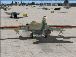
This is Pease AFB, NH. as it was in the late '70s when it was the 509th Strategic Air Command base. Aircraft stationed at Pease AFB were the FB-111A mach 2+ swing-wing bombers, KC-135 refueling tankers and the T-37 trainers.
Included in this scenery package are:
* Parking spots for Military Combat and Cargo aircraft.
* Ground support equipment and vehicles
* AI FB-111A , KC-135, and T-37 aircraft and flight plans
* AI FB-111A's that ATC addresses by tail number
* Custom created static FB-111A and KC-135 aircraft
* Custom buildings included hangers, alert bunker, and control tower.
* Custom Hangers have night lighting and static aircraft with night textures.
* Alert Area with shelters and static FB-111A with SRAMs and KC-135 aircraft
* Custom signs and flags.
* Individual add on transient aircraft and flight plan packages to save frame rates
* AI fighter aircraft have afterburners
* Flyable FB-111A (with textures that match AI and Static aircraft)
* Flyable KC-135 (with textures that match AI and Static aircraft)
Add-ons to scenery available at my website: http://sites.google.com/site/shess0757/home
* Additional AI aircraft with flight plan packages
| Filename: | Pease_AFB_FSX_Version_20.zip |
| License: | Freeware |
| Added: | 10th December 2010, 02:27:53 |
| Downloads: | 1,383 |
| Author: | Steve Hess and Guy Diotte |
| Size: | 30.84 MB |
| Category: Flight Simulator 2004 - Scenery | |
| Hewanorra TLPL on Saint Lucia in the eastern Caribbean |
|
Images related to this file:
File Description:
St Lucia island is to the north of the Grenadines, between Martinique and Saint Vincent. St Lucia is nearly 30 miles long and has a population of 175,000, with two airports. Hewanorra International is at the southern end of the island, the end furthest from the capital, Castries. The reason for this is that at the southern end it was possible to build a runway almost 9,000 feet long, while the airport in the north (Vigie) could not be extended further to accomodate the largest jets. The airport was originally a USAAF base, converted to commercial use.
All buildings are made with photographic textures and include the new terminal and a new control tower. The apron has been extended so that 747's etc can be accommodated, and there are regular international flights by Virgin, BA, Air Canada, Air France, etc and local connecting flights by LIAT; the AI includes both major international airlines and LIAT. The towns around the airport (Vieux Fort etc) are included here: the scenery is based on the "Lesser Antilles Mesh" which is required and can be downloaded for free.
| Filename: | Hewanorra_TLPL_on_Saint_Lucia_in_the_eastern_Carib.zip |
| License: | Freeware, limited distribution |
| Added: | 11th June 2013, 16:23:49 |
| Downloads: | 831 |
| Author: | Roger Wensley |
| Size: | 4.25 MB |
| Category: Flight Simulator 2004 - Scenery | |
| Wrigley CYWY - Northwest Territories, Canada |
|
Images related to this file:
File Description:
Wrigley is the next in a series of airfields that follow (approximately) in a southward direction that early access route to the Canadian northern shore, the Mackenzie River. At the far northern end there is Tuktoyaktuk, then Inuvik, Fort McPherson, Fort Good Hope, and Deline, all posted. Wrigley is at 489 feet asl and on the east bank of the the Mackenzie, around 135 miles due south of Deline. The town of Wrigley has a population of only 125 or so folks, and was relocated to its current position in 1965 from Fort Wrigley to be near the WW2 era airfield; I have no idea where Fort Wrigley is, or was. The airport is just over a mile south of the town, and has 3,500 feet of gravel runway. North Wright Air have scheduled flights to here and other airfields up and down the Mackenzie (including Deline, Fort Simpson, and Fort Good Hope etc) which is reflected in the revised AI. There is again a mandatory radio frequency but I have set the "tower" as unmanned so you will announce intentions and join downwind. There is no fuel available.
| Filename: | Wrigley_CYWY__Northwest_Territories_Canada.zip |
| License: | Freeware, limited distribution |
| Added: | 5th July 2014, 21:01:37 |
| Downloads: | 211 |
| Author: | Roger Wensley |
| Size: | 3.81 MB |
| Category: Flight Simulator 2004 - Scenery | |
| CZFN - Tulita - Northwest Territories, Canada |
|
Images related to this file:
File Description:
Tulita (Fort Norman until 1996) is another in the series of airfields that follow (approximately) the Mackenzie River. At the far northern end of the river and on the eastern side of the delta there is Tuktoyaktuk, then Inuvik, Fort McPherson, Fort Good Hope, Deline, Wrigley, Fort Simpson Island and Fort Simpson, and then Fort Liard at the southern end of the list of those in the Northwest Territories. South of Fort Liard there are Peace River and Dawson Creek, both of which are already posted. Tulita is at the junction of the Mackenzie and Great Bear Rivers, on the east bank of the Mackenzie and the south bank of the Great Bear, around 40 miles southeast of Norman Wells. The town has a population of about 480 folks. The airport is above and to the east of the town, and has 3,000 feet of gravel runway. The scheduled flights are by North Wright and I have also added a Buffalo DC3 and GA. There is a mandatory radio frequency but in this case I have set the "tower" to "unmanned" so you will report position and intentions. There is no fuel available.
| Filename: | CZFN__Tulita__Northwest_Territories_Canada.zip |
| License: | Freeware, limited distribution |
| Added: | 12th July 2014, 08:05:54 |
| Downloads: | 271 |
| Author: | Roger Wensley |
| Size: | 2.66 MB |
| Category: Flight Simulator 2004 - Scenery | |
| CEN5 - Cold Lake Regional & revised CYOD - Cold Lake, Alberta, Canada |
|
Images related to this file:
File Description:
CYOD was made by John Stinstrom and you should download and install it first; there is also a "fix" for the apron lights textures. I am posting a modified AFCAD for CYOD with John's knowledge; this changes gates and atc identifications for the gates, so that with my version of the CYOD AI there are pairs of F18s taking off every 20 minutes or so. This means that the nearby Cold Lake Regional CEN5 works within the busy environment of flights to and from the nearby base. There is also a Hawker Hunter that drops in, and transport planes. The planes are listed so that you will know which are required to be downloaded. CEN5 may have "Regional" attached to its name, but there are now no scheduled flights and it is a peaceful and relaxed little airfield. There is fuel, and a little clubhouse building, and some hangars. There is ai for it here, using original FS9 planes so no downloads are required. Right hand circuits for runway 25 to stay as far away as possible from CYOD, and it is the CYOD tower that controls all flights in the area.
| Filename: | CEN5__Cold_Lake_Regional___revised_CYOD__Cold_Lake.zip |
| License: | Freeware, limited distribution |
| Added: | 11th May 2014, 13:41:51 |
| Downloads: | 485 |
| Author: | Roger Wensley |
| Size: | 12.25 MB |
| Category: Flight Simulator 2004 - Scenery | |
| Durban Island CWFB FOX-E DEW line station in Nunavut, Canada |
|
Images related to this file:
File Description:
Durban Island is 40 miles north of Cape Dyer on the southeast corner of Baffin Island, and around 60 miles southeast of Qikiqtarjuaq (known as Broughton until recently). Sitting on the top of the island is FOX-E, an intermediate station that was part of the DEW line. There is no runway (and once you have seen the island you will know why) and the station and its (usually) five man crew were supported by helicopter flights from Cape Dyer. The main feature is a 300' high mast, topped by comms gear to link both to Broughton to the north and Cape Dyer to the south. There was only one really habitable building, 80' x 30' in round figures, and this contained the generators, technical spaces, sleeping areas, kitchen, mess, and showers etc. There were also what were known as Anderson shelters, originally put up to house the construction crew and used in the summer for any maintenance people who visited for short periods. There was also a garage for a snow cat and tanks for fuel. And a view.
This post also includes new bgls for Cape Dyer to provide the 300' tower there too.
| Filename: | Durban_Island_CWFB_FOXE_DEW_line_station_in_Nunavu.zip |
| License: | Freeware, limited distribution |
| Added: | 1st July 2011, 22:11:33 |
| Downloads: | 313 |
| Author: | Roger Wensley |
| Size: | 1.87 MB |
| Category: Flight Simulator 2004 - Scenery | |
| Antique Scenery, San Jose de Buenavista, Antique, Philippines |
|
File Description:
ANTIQUE SCENERY,Full Version 2.0
October 10,2003
Enjoy this ANTIQUE SCENERY located at San Jose de Buenavista,Antique,Philippines.This scenery features the new EVELIO B. JAVIER airport terminal,ATO building, and the Antique airport CRASH AND FIRE RESCUE STATION with full night lighting.
This scenery is designed to optimize framerates.Special thanks goes to CAPT. JOHN L. MAKANI for the AERIAL and CLOSE UP shots he made at this new Antique airport.
Asian Spirit now serves this airport three times a week. Using the ASIAN SPIRIT YS-11, or sometimes using the ASIAN SPIRIT LET-410,it serves antique airport on Mondays, Wednesdays and Fridays.Install the included TRAFFIC TOOLS FILES and watch out for the ASIAN SPIRIT YS-11 land perfectly in this airport M-W-F at 11:35 a.m.from Manila and take off again at 12:05 p.m. back to Manila.Install the included AFCAD files and watch your favorite genav aircraft land and take off perfectly at the center of the runway.Install the included Editvoicepack VCPMOD file and hear the Antique Tower pronounce the word "Antique" correctly or hear the ATC say "Antique" instead of "Romeo Papa Victory Sierra".
| Filename: | Antique_Scenery_San_Jose_de_Buenavista_Antique_Phi.zip |
| License: | Shareware, time limited |
| Added: | 11th October 2003, 02:08:18 |
| Downloads: | 4,112 |
| Author: | Ver Walter L. Gulfan |
| Size: | 1.73 MB |
| Category: Flight Simulator 2004 - Scenery | |
| Kogd-Ogden,Utah |
|
Images related to this file:
File Description:
KOGD-Ogden,Ut
Take your sailboat to the Great Salt Lake inland sea or hike the many mountains and enjoy the vistas offered atop the lofty peaks. Visit the quiet mountain valley town of Eden to the east of KOGD with its annual balloon festival and summer fun on Pineview dam or spend the day shopping the shops of Brigham City to the north or Salt Lake City to the south. Fly over the Great Salt Lake to the west.
See the Ogden airport come alive with this must have add-on. With the help of Google Earth and FS Earth I have recreated the Ogden airport, with its new taxiway A (from a site visit), and the surrounding cities and towns to look as real as possible.
Made with Ultimate Terrain, but the airport should be ok with default FS9. (No guarantee though ;-)
The scenery enhancements were made with Ultimate Terrain in place. I modified the landclass to look more like the real thing. The airport is very close to a exact replica of KOGD! The crane by the tower was there when I took the pictures so I included it.
| Filename: | KogdOgdenUtah.zip |
| License: | Freeware |
| Added: | 20th January 2009, 13:42:09 |
| Downloads: | 1,344 |
| Author: | Alan C. Heiner |
| Size: | 15.59 MB |
© 2001-2026 AVSIM Online
All Rights Reserved
Privacy Policy |