
Where Flight Simulation Enthusiasts Gather from Around the World!
AVSIM Library - Search Results

| Category: Flight Simulator 2004 - Scenery | |
| Portland KPDX Scenery Enhancement |

|
File Description:
Re-upload. The default FS9 KPDX scenery is not bad, but it's out of date and lacks jetways. I didn't set out to recreate KPDX in detail, just to make the terminal building more accurate. This enhancement has the following features:
1. A new terminal building and parking structure are now accurately sized and placed.
2. The control tower was moved to its correct position.
3. The correct number of jetways has been added.
4. Ramp lighting has been added.
5. Some inaccuracies in the aprons and taxiways have been fixed.
6. The misaligned ILS for runway 28L has been corrected.
7. The afcad has been redone. If you are using Ultimate Traffic you should see more accurate AI traffic parking.
| Filename: | Portland_KPDX_Scenery_Enhancement.zip |
| License: | Freeware |
| Added: | 21st June 2010, 11:09:47 |
| Downloads: | 4,324 |
| Author: | Sidney Schwartz |
| Size: | 1.19 MB |
| Category: Flight Simulator X - Scenery | |
| channel ships |
|
File Description:
Ships, loads of ships in the English Channel (excusee: Pas de Calais)
About 60 ships (apart from ai ships)
When flying over the Channel, pilots say that an emergency landing here would certainly mean a crash into a ship; there are that many ships about.
You'll see Cargo ships, containerships, super tankers. Cruisliners are symbolic for the ferries sailing to and from Calais / Dover and Dunkirk.
Corrected for use with Ultimate terrain Europe
To be able to see this scenery I had to make a fake airport and named it LF00 (read: LF zero-zero)
There's a tower position as well, midways the channel with a height of 100 mtr. I haven’t tested it, it's not visible either.LF00 is visible in your GPS. Have fun.
| Filename: | channel_ships.zip |
| License: | Freeware, limited distribution |
| Added: | 12th January 2009, 13:00:36 |
| Downloads: | 3,771 |
| Author: | Joost Visser / ade1.37 |
| Size: | 134.43 KB |
| Category: Prepar3D V1-4 - Scenery | |
| Saint Helena Airport (FHSH) |
|
Images related to this file:
File Description:
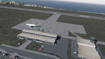
​This is a reworked version of the FSX freeware Saint Helena Airport (FHSH) by Carlyle Sharpe for P3Dv4. Buildings and signs are created by Frits Beyer.
The following has been modified or added:
- Designation of the gate sizes changed
- Taxiway signage turned in view direction
- ILS approach aligned (RWY 20 / Frequency 109.3 / Course 179)
- Added Dynamic Lighting
- Added GSX L2 configuration (optional)
​
REQUIREMENTS:
- St. Helena, Ascension, and Tristan da Cunha Islands
https://library.avsim.net/esearch.php?CatID=fsxscen&DLID=195117
- FHSH - St. Helena Island **UPDATE **
https://library.avsim.net/esearch.php?CatID=fsxscen&DLID=195396
- FHSH - St. Helena Island Custom Terminal, Tower, and Signs - St. Helena, South Atlantic
https://library.avsim.net/esearch.php?CatID=fsxscen&DLID=195164
RECOMMENDATIONS (OPTIONAL):
- GSX L2 latest version
https://www.fsdreamteam.com/products_gsx.html
| Filename: | Saint_Helena_Airport_FHSH.zip |
| License: | Freeware |
| Added: | 3rd April 2021, 18:16:17 |
| Downloads: | 982 |
| Author: | Frank Drebing / Carlyle Sharpe / Frits Beyer |
| Size: | 2.07 MB |
| Category: Flight Simulator X - Scenery | |
| FSX SCENERY ELLX Luxembourg Intl Airport and City and AI package |
|
Images related to this file:
File Description:
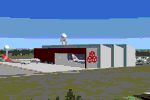
This is the most complex, complicated scenery I have attempted. Some success with KGRB Green
Bay's transparent windows and interiors plus the photoreal attempt with Lambeau Field encouraged me to try a large European scenery. This scenery
is ELLX Luxembourg International Airport, headquarters for CargoLux Airlines and its large fleet of Boeing 747-8Fs and Luxair,
the national air service of Luxembourg. I have modeled transparent windows for terminals with detailed interior seating and
shops, the large unique Cargolux maintenance hangar, the air cargo terminal, control tower, radar domes,and many custom made
hangars and buildings. AI textures and flight plans provided for the air rescue based at ELLX. Some assembly required
(i.e. other downloads for some buildings, objects, AI aircraft to show up.)
Dan French
| Filename: | FSX_SCENERY_ELLX_Luxembourg_Intl_Airport_and_City_.zip |
| License: | Freeware, limited distribution |
| Added: | 26th March 2022, 19:59:56 |
| Downloads: | 1,011 |
| Author: | Dan French |
| Size: | 129.98 MB |
| Category: Flight Simulator X - Scenery | |
| KSLC - Salt Lake City Intl Airport 2020, Utah, USA |
|
Images related to this file:
File Description:
I have been asked many times could i do an update for SLC, knowing there were going to be major changes there I held off until now when someone sent me a plan for the new terminal layout and its taxiways, so here is my interpretation of what it may look like in 2020.
This is a version of Salt Lake City Intl Airport with two optional files and made only for FSX, do not use in P3D: There is one version with the Crosswind runway 14/32 operating where all 4 runways will be used for takeoff/landing and one version as the default airport runway operation, The new south terminal A and north concourse B have been designed similar to the plan i have, i also had to take a guess at which airlines will park where so may not be accurate on opening day, as a Delta hub they are only assigned to terminal A, most other airlines are assigned to the north concourse B, transient parking is retained in the same place, the north cargo ramp and buildings updated, runway 17/35 is now parallel with 16L/34R which is also part of the upgrade plan, and the approaches for it aligned with the new position, all other approaches and frequencies updated to the latest charts where needed, extra fuel trucks, Helipads/start locations now in their correct positions, De-icing pads added, support vehicle roads rebuilt and many other scenery improvements and objects added, airport views are from the roof of the control tower (when in tower view) please view the readme before installation,
| Filename: | KSLC__Salt_Lake_City_Intl_Airport_2020_Utah_USA.zip |
| License: | Freeware, limited distribution |
| Added: | 6th March 2018, 04:23:35 |
| Downloads: | 44,413 |
| Author: | Ray Smith |
| Size: | 4.91 MB |
| Category: Flight Simulator X - Scenery | |
| Mesh-South America MeSA_G04 |
|
File Description:
FSX Mesh South America Project:
This terrain mesh file is a part of a whole project covering all the Continent
of South America and some islands, divided in tiles identified in a map by its
column (letters) and rows (numbers).
Those files were multi-LOD compiled from 90m SRTM2 source data, reprocessed
with 3DEM to remove voids and spikes, providing a 76.4m (LOD9) horizontal
resolution topography intended for use only in FSX updated with SP1.
Although not well documented, to improve performance, the updated FSX loads DEM
files in threads and only the closer terrain (about 5-10 NM from the point of view)
is rendered in high detail, while at far distances FSX shows up its default low
resolution mesh, when there is not a third part terrain mesh compiled in all
others intermediate level of details (multi-LOD).
THIS FILE:
FSX_MeSA_G04 (Column G x Row 04)
covers the area inside the boundaries:
N = 0º 0' S; S = 5º 37.5' S;
W = 45º 0' W; E = 37º 30' W;
AUTHORS:
Hely Heck Junior - Magrao ( [email protected] )
and Jose Lobo ( [email protected] )
TerraBrasilis: www.terra-brasilis.org
| Filename: | MeshSouth_America_MeSA_G04.zip |
| License: | Freeware |
| Added: | 15th June 2007, 00:10:58 |
| Downloads: | 867 |
| Author: | Hely Heck Jr. and José Lôbo |
| Size: | 35.9 MB |
| Category: Flight Simulator 2004 - Scenery | |
| International Pan American Airport - Dinner Key, Coconut Grove (Miami), Florida |
|
File Description:
"From 1933-1945, Dinner Key in Coconut Grove (Miami), Florida was Pan American Airways Latin
American Hub for its Flying Boat fleet. Dinner Key was so named because many families used to
come out and have picnic dinners and watch the Sikorsky’s, Martin’s, and Boeing’s leave for
exotic ports. In 1950, the terminal became Miami’s City Hall with the surrounding area
becoming a marina."
For Default scenery.. not tested in others. Uses both RWY12(latest version with all add on
libraries included) AND Lago FSE (Payware)
Two methods of installing.. which ever works best for you. One - simply drop the Dinner Key
folder into your add-on scenery section of flightsim and install according to SOP... start it
up..add and activate it close program and start again or TWO - remove the three .bgl files
from the scenery file ... the afcad, the exclude, and the rwy12 .bgl and place them in your
add-on scenery\scenery file ... then start flightsim.. it will automaticly configure it.
the .se2 file goes into LAGO\FSE\Data file (you will need lago for this to work.
comments or questions [email protected]
| Filename: | International_Pan_American_Airport__Dinner_Key_Coc.zip |
| License: | Freeware |
| Added: | 30th August 2005, 21:22:33 |
| Downloads: | 1,473 |
| Author: | Dale Caruso |
| Size: | 332.34 KB |
| Category: Flight Simulator 2002 - Utilities | |
| FlightSim Manager v1.0.4 |
|
File Description:
FlightSim Manager 1.0.4
FlightSim Manager is a great tool for managing addons to Microsoft Flight Simulator 2002. You may easily import your existing Aircraft, Panels, Sounds and Scenery. FlightSim Manager can also to install new aircraft and scenery directly from distribution ZIP files you may have downloaded using an Easy to use Wizard. While installing new aircraft/scenery FlightSim Manager will automatically copy the required files and repair it if necessary. You may even add or remove aircraft variants as you wish. The comprehensive Hangar management allows you to manage and configure your addons off your live FS2002 installation. You can mass add scenery, clean gauges and a fly from anywhere in the world using an map view. Create Texture Sets and install with ease. Automatically Save Screenshots from FS. Launch FlighSimulator in High Priority mode with Random Splash screen and more.
FSM can also diagnose Flight Simulator scenery, aircrafts, gauges, effects, alias used and such - with a repository with easy restore feature.
Please search on my name to make sure you are downloading the latest version of this program.
| Filename: | FlightSim_Manager_v104.zip |
| License: | Freeware |
| Added: | 27th June 2004, 21:57:04 |
| Downloads: | 2,167 |
| Author: | Rana Hossain |
| Size: | 3.3 MB |
| Category: Flight Simulator X - Scenery | |
| Mesh South America / MeSA B11 |
|
File Description:
FSX Mesh South America Project:
This terrain mesh file is a part of a whole project covering all the Continent
of South America and some islands, divided in tiles identified in a map by its
column (letters) and rows (numbers).
Those files were multi-LOD compiled from 90m SRTM2 source data, reprocessed
with 3DEM to remove voids and spikes, providing a 76.4m (LOD9) horizontal
resolution topography intended for use only in FSX updated with SP1.
Although not well documented, to improve performance, the updated FSX loads DEM
files in threads and only the closer terrain (about 5-10 NM from the point of view)
is rendered in high detail, while at far distances FSX shows up its default low
resolution mesh, when there is not a third part terrain mesh compiled in all
others intermediate level of details (multi-LOD).
THIS FILE:
FSX_MeSA_B11 (Column B x Row 11)
covers the area inside the boundaries:
N = 39º 22,5' S; S = 45º 0' S;
W = 82º 30' W; E = 75º 0' W;
AUTHORS:
Hely Heck Junior - Magrao ( [email protected] )
and Jose Lobo ( [email protected] )
TerraBrasilis: www.terra-brasilis.org
| Filename: | Mesh_South_America__MeSA_B11.zip |
| License: | Freeware |
| Added: | 11th June 2007, 22:11:28 |
| Downloads: | 1,154 |
| Author: | Hely Heck Jr. and José Lôbo |
| Size: | 1.55 MB |
| Category: Flight Simulator X - Scenery | |
| Mesh South America / MeSA B13 |
|
File Description:
FSX Mesh South America Project:
This terrain mesh file is a part of a whole project covering all the Continent
of South America and some islands, divided in tiles identified in a map by its
column (letters) and rows (numbers).
Those files were multi-LOD compiled from 90m SRTM2 source data, reprocessed
with 3DEM to remove voids and spikes, providing a 76.4m (LOD9) horizontal
resolution topography intended for use only in FSX updated with SP1.
Although not well documented, to improve performance, the updated FSX loads DEM
files in threads and only the closer terrain (about 5-10 NM from the point of view)
is rendered in high detail, while at far distances FSX shows up its default low
resolution mesh, when there is not a third part terrain mesh compiled in all
others intermediate level of details (multi-LOD).
THIS FILE:
FSX_MeSA_B13 (Column B x Row 13)
covers the area inside the boundaries:
N = 50º 37,5' S; S = 56º 15' S;
W = 82º 30' W; E = 75º 0' W;
AUTHORS:
Hely Heck Junior - Magrao ( [email protected] )
and Jose Lobo ( [email protected] )
TerraBrasilis: www.terra-brasilis.org
| Filename: | Mesh_South_America__MeSA_B13.zip |
| License: | Freeware |
| Added: | 11th June 2007, 22:12:07 |
| Downloads: | 1,160 |
| Author: | Hely Heck Jr. and José Lôbo |
| Size: | 1.82 MB |
© 2001-2026 AVSIM Online
All Rights Reserved
Privacy Policy |