
Where Flight Simulation Enthusiasts Gather from Around the World!
AVSIM Library - Search Results

| Category: Flight Simulator 2004 - Scenery | |
| CYZS - Coral Harbour - Nunavut, Canada Modified V1 |

|
Images related to this file:
File Description:
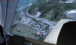
This modified version of Coral Harbour corrects the PAPI postion on the runway, installs new taxiway lights and windsocks, and modifies the AI. This is a complete version and does not require you to have installed the original. Coral Harbour is on Southampton Island, which partly blocks the northern end of Hudson Bay and is around the size of Switzerland. The village has a population of just under 800 people and is some 200 miles from Cape Dorset, Ivujivik, and Repulse Bay, and 230 miles from Chesterfield Inlet to the southwest. The airfield is inland from the village and the 5,000 feet of gravel runway is aligned 155T/335T where T stands for "true" as opposed to magnetic in the Northern Domestic Airspace. JETA-1 fuel is officially available, and in practice so is 100LL, though the latter will be in drums. The visiting AI airlines are First Air and Calm Air, and there is a GA plane too that is stock FS9.
| Filename: | CYZS__Coral_Harbour__Nunavut_Canada_Modified_V1.zip |
| License: | Freeware, limited distribution |
| Added: | 23rd August 2014, 11:25:23 |
| Downloads: | 222 |
| Author: | Roger Wensley |
| Size: | 12.92 MB |
| Category: Flight Simulator X - Scenery | |
| Coffs Harbour V3, Australia |
|
File Description:
Coffs Harbour is on the east coast of Australia mid way between Brisbane (YBNE) and Sydney (YSSY). It is a busy regional airport taking a daily 737 from Virgin and numerous regional flights by Qantas and Brindabella Airlines. It handles 30,000 airport movements a year and is benefitting from a 4 million dollar expansion started in 1999.
This is a reworked version of Coffs Harbour for FS9. All models are GMAX and FSDS 3 and xml coded. Improvements have been made to Mutton Bird Island and southern headland, the harbour, Coffs shopping centre from photo textures taken recently, Sawtel shopping centre, the airport layout includes all but one of the real life hangars and are in as accurate position as the FSX airport layout will allow (pretty accurate in FSX). Additions include Opal Cove resort, coaslines changed to be accurate and include beaches!!, rivers more accurate and the main road with traffic realigned.
This is an ongoing project so any suggestions welcome.
| Filename: | Coffs_Harbour_V3_Australia.zip |
| License: | Freeware, limited distribution |
| Added: | 9th May 2007, 12:49:11 |
| Downloads: | 4,875 |
| Author: | John Ross |
| Size: | 11.98 MB |
| Category: Prepar3D V1-4 - Aircraft Repaints, Textures and Modifications | |
| Consolidated PBY-5 VP-101 |
|
Images related to this file:
File Description:

This folder contains a repaint for the Aerosoft PBY Catalina for FSX, representing PBY-5 BuNo2446. It was originally assigned to VP-23 at Pearl Harbor in November 1941, and all its aircraft were destroyed during the December 7 attacks by the Japanese. 2446 was rebuilt using parts from other PBY's and reassigned to VP-21. It flew to Perth, Western Australia in April 1942, becoming 'Boat 1' with VP-101. Lt (jg) Tom Pollock flew it with medicine and ammunition to Corregidor via Darwin just before the island surrendered in late April. 2446 was lost in action over New Guinea in August 1943, still flying with VP-101. Repaint by Jan Kees Blom, based on the paintkit by Aerosoft. I have included two versions, one for P3Dv5 (without reflections) and one for the earlier sims (FSX/P3Dv1-4), with slight reflections. I felt these were too shiny in v5, but feel free to try for yourself.
| Filename: | Consolidated_PBY5_VP101.zip |
| License: | Freeware |
| Added: | 5th June 2020, 21:01:08 |
| Downloads: | 118 |
| Author: | Jan Kees Blom |
| Size: | 20.29 MB |
| Category: Flight Simulator 2004 - Aircraft Repaints, Textures and Modifications | |
| Merpati Nusantara BAC One-Eleven 401 N5032 |
|
File Description:
Looking particualry smart with a polished bottom, rare in One-Elevens, Merpati used this aircraft on lease from American Airlines for about six months. First flying 06 June 1966 as N5032 this machine was re-registered G-ATVU for a demo tour of Sweden between the 8th and 13th of that month. Reverting to its American registration for delivery on the 21 June it served American Airlines until leased to Merpati in August 1971. Returned to American early the following year it was leased to LANICA as AN-BHN before passing to Island Airways as VP-BDI. In May 1974 it was sold to British Airways as G-BBMF and served until withdrawn and stored in October 1988. Transferred to Birmingham European, it's UK marks were cancelled in August 1991 on sale to Okada Air. It was finally withdrawn at Benin City in December 1997. Requires the BAC One-Eleven 400 model by David Maltby
| Filename: | Merpati_Nusantara_BAC_OneEleven_401_N5032.zip |
| License: | Freeware |
| Added: | 8th August 2005, 19:41:43 |
| Downloads: | 237 |
| Author: | Garry Russell |
| Size: | 577.85 KB |
| Category: Flight Simulator X - Scenery | |
| CYCD (2012) Version 3 for FS9, FSX and Prepar3D |
|
Images related to this file:
File Description:
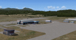
CYCD (2012) is an update to Ken Peter's CYCD Nanaimo-Collishaw Airport (Vancouver Island, British Columbia, Canada). The airport has recently completed a major runway
extension and installed an ILS for Rwy 16. The five flashing-red beacons that guide the way on a night approach to Rwy 34 are included. To the extent possible, this update
reuses Ken's custom buildings and objects (but you don't need to have Ken's version installed). As well, a selection of SAMM-generated static aircraft are scattered around the
aprons supplemented by a number of AI aircraft that do touch 'n gos from time to time. CYCD (2012) is compatible with ORBX FTX USA Canada Pacific Northwest and both versions
of Ultimate Terrain.
Generally, this new version is visually identical to its predecessor - even though quite different internally. As well, to the extent possible, it is compatible with
Prepar3Dv2. (v3.03 fixes a vehicle texture issue in 3.02)
| Filename: | CYCD_2012_Version_3_for_FS9_FSX_and_Prepar3D.zip |
| License: | Freeware |
| Added: | 22nd June 2014, 17:18:09 |
| Downloads: | 3,987 |
| Author: | Don Grovestine |
| Size: | 64 MB |
| Category: Prepar3D V1-4 - Scenery | |
| TNCC - - Curaçao International Airport V 2.0 |
|
File Description:
This is an improved version of my previous senario for TNCC. This version has substantial improvements in the terminals and areas of the airport.
Curaçao International Airport (IATA: CUR, ICAO: TNCC), (Dutch: Hato Internationale luchthaven) also known as Hato International Airport (formerly Dr. Albert Plesman International Airport), is the only airport for the island of Curaçao.
The airport is located on the north coast of Curaçao, 12 kilometres (7.5 mi) from the capital Willemstad. Curaçao International Airport services flights from the Caribbean region, South America, North America and Europe and has the third longest commercial runway in the Caribbean region after Rafael Hernández Airport in Puerto Rico and Pointe-à -Pitre International Airport in Guadeloupe.
The airport serves as a main base for Divi Divi Air, Jetair Caribbean as well as EZAir; it formerly served as a main base for ALM, KLM, DCA, DAE and Insel Air.
| Filename: | TNCC___Curaao_International_Airport_V_20.zip |
| License: | Freeware |
| Added: | 25th June 2021, 18:19:49 |
| Downloads: | 450 |
| Author: | Eduardo Puelker |
| Size: | 37.41 MB |
| Category: Flight Simulator X - AFCAD Files | |
| MYNN - Lynden Pindling Intl - Nassau, Bahamas |
|
Images related to this file:
File Description:
MYNN - Lynden Pindling Intl - Nassau, Bahamas
Lynden Pindling International Airport was formerly known as Nassau International Airport and is the largest airport in the Bahamas, and the largest international gateway into the country.
It is a major hub for Bahamasair and is located in western New Providence island near to the capital city of Nassau. The airport contains U.S. Border preclearance facilities allowing all US flights to operate as domestic flights upon arrival at their destination.
Currently, the airport has 2 runways, more than 30 gates and 482,000 sq ft (44,800 m2) of terminal space. The redevelopment updated the airport facilities to world-class standards and expanded terminal capacity. The work was carried out in three stages. The first stage was completed in March 2011.
Using ADEx 1.50, aeronautical maps and Google Earth all these and future changes have been built into the default FSX airport. Crosswind Runway Technique has been implemented to open up all runways.
| Filename: | MYNN__Lynden_Pindling_Intl__Nassau_Bahamas.zip |
| License: | Freeware |
| Added: | 4th December 2012, 17:33:06 |
| Downloads: | 1,956 |
| Author: | Menno C. Robert |
| Size: | 4.16 MB |
| Category: Flight Simulator X - Scenery | |
| Carnes Farm |
|
Images related to this file:
File Description:
These are the files that I talked about in the Prepar3d forums. I created these objects for Fs9, then upgraded them to the scenery SDK for FSX. They were created 10 years ago in GMAX, and I have used them successfully ever since in Prepared 1.4 as well.
For some reason the individual farmhouse and other objects that I created are not showing up in Prepar3d version 2.0.
That's where you guys come in! These files are free to use in anyway you want as long as proper attribution is given, but, I would like you guys who have both Prepar3d 1.4 and 2.0 to try them out in both and report back to me as to whether you have the same problems that I do. That's your only fee. And I'd like you guys to give it a shot in both, or all four( I am not sure that they will work in FS9 anymore, but try it out. Unfortunately I can't recompile my FSX SDK Files back to FS9 if it doesn't work).
What's included:
1. Photo real scenery of Barbourville, 10 miles to the north west of stinking Creek where we live, and;
2. Photo real scenery of the farm area and stinking Creek, upon which I have placed my GMAX objects;
A. The farm house.Carnes Farm From the Bridge at 500 AGL.jpg
B. The barn, shed and the RV in back of the farmhouse.
C. A two-story long structure the top of which is an apartment but the bottom of which is a re-creation of Mama Carne's store, along with all the real wood floors shelves and original contents.. It is also o n Google earth in 3-D as it is here with further description .
... A little note on Gmax.. Mama Carne's store was one the first structures that I built in Gmax. It was just a box. Later, I added the true architectural features that you see including the steps and rails which took about as long to create as it would have to Saw and fit and hammer the real rails, risers and steps.
D. K-6, my little 2300 foot strip for runways 03 and 21. It has VOR - (117.55), ILS(110.1), and NDB(222).
E. Gerald Bingham's house, 1/4 mile up Warriors Path North from us.( mostly dirt road with gravel topping).
F. Dewitt Baptist Church.
Off property Knox county
G.Escoe's Store and Post Office complete with great prices for gas at the included pumps.
Escoes.jpg
H. Rex allen's killer corner...sheds and farm equipment on the sharpest bend on Stinking Creek...my son went off it with a flat tire, unscathed, but more than several have lost their lives on that curve... there may be several iterations of the sheds...just delete or rename the wrong ones...I was experimenting with ModelConverterX, Arno Gerretsen's wonderful model and object scenery tool.
I. sitting on top of the Barbourville Photo real scenery Barbourville PhotoReal over the shopping center.jpg is the Barbourville P3D Shopping Center2.jpg shopping center all the stores and all the storefronts ... it's on 25 E. as you head into Barbourville.
Recreated, is the entire shopping center with the now outmoded Wal-Mart sign. Probably my magnum opus.
note on the Gmax scenes.
All of the scenery was either directly measured and if not practical for a such a long measuring device, walked off, as in the Stinking Creek Bridge and shopping center. All of the objects were then photographed, in 360° where possible and saved as texture for inclusion in the Gmax model.
Enjoy!
...oh... how do you get there? Wellllll.... situate yourself at Middlesboro (1a6), and tune your Nav radio to K-69's VOR, 117.55, take off and climb to 3500 feet...grinnnnn
Welcome to Knox County Kentucky!
| Filename: | Carnes_Farm.zip |
| License: | Freeware |
| Added: | 2nd December 2013, 05:34:20 |
| Downloads: | 453 |
| Author: | Chas Honce |
| Size: | 91.13 MB |
| Category: Flight Simulator X - Aircraft Repaints, Textures and Modifications | |
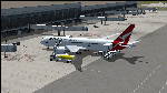
| Qantas Consolidated PBY-5 5 paints |
|
Images related to this file:
File Description:

Five repaints for the Aerosoft PBY-5 Catalina in the colors of PBY-5's operated by Qantas on the 'Double Sunrise Service' between Western Australia and Ceylon between 1943 and 1945.
In 1943, Royal Australian Air Force personnel were seconded to operate Catalinas under the banner of Qantas. The plan called for flights between Perth, Western Australia, and RAF Base Koggala in southern Ceylon (now Sri Lanka). The flights were the longest non-stop air route of any airline, over 3,500 nautical miles (6,480 km) across the Indian Ocean. Navigating without the aid of radio, the crews relied solely on rudimentary navigation by compass and stars during the trip.
Only Catalinas had that kind of range, so five PBY-5 flying boats were converted to make them suitable for the trip.
They received camouflage paint, with a RAAF roundel on the fuselage, but also a civilian registration, since they were officialy operated by Qantas, and they were named after the stars they would be using for navigation:
Vega Star (G-AGFL/FP221 - tail code 1)
Altair Star (G-AGFM/FP244 - tail code 2)
Rigel Star (G-AGID/JX575 - tail code 3)
Antares Star (G-AGIE/JX577 - tail code 4)
Spica Star (G-AGKS/JX287 - tail code 5)
Taking between 27 and 33 hours, with departure timed so that the flight crossed Japanese occupied territory during darkness, the crews would observe the sunrise twice, which led to the service being known as "The Double Sunrise". The flight route flown was along the coast from Perth to Exmouth then setting out towards Cocos (Keeling) Island or Christmas Island (though neither was actually sighted during the flight) and onto Kogalla, a journey of approximately 3,580 nautical miles (6,630 km). After the success of the initial flights, it was decided to run a weekly service, with some services flying over Rottnest Island and then taking a direct line to Kogalla. As part of the Australia-England air route there was a surface component from Kogalla to Karachi that added considerable time to the service. This was later replaced by the Double Sunrise service, with Karachi to England flown by BOAC. Air crews would change in Kogalla taking the next plane in either direction minimising the time taken to complete the journey.
Though stripped of all non-essential equipment, including de-icing equipment and insulation, the average takeoff weight was 15,900 to 16,000 kg; this included 9,040 liters of fuel, which gave the Catalina a range of 3,600 nautical miles (6,700 km). The service made 271 crossings, delivered over 4,500 kg of mail and carried 860 passengers, including among them British MP Edith Summerskill and the journalist Keith Murdoch. 'The Secret Order of The Double Sunrise' was an illustrated certificate given to passengers aboard the flying boats of the Australia-England air link, to attest they had been airborne for more than 24 hours.
After the war the five modified Catalinas that had flown The Double Sunrise service were scuttled.
Repaints by Jan Kees Blom, based on the paintkit by Aerosoft
| Filename: | Qantas_Consolidated_PBY5_5_paints.zip |
| License: | Freeware |
| Added: | 13th July 2018, 20:38:43 |
| Downloads: | 176 |
| Author: | Jan Kees Blom |
| Size: | 49.87 MB |
| Category: Flight Simulator X - Original Aircraft | |
| Boeing 787-8XLR Qantas |
|
Images related to this file:
File Description:
Qantas is requesting proposals (Dec 2018) for design of an aircraft model or variation that is capable of non-stop flights over 10,000 nm for YSSY to EGLL and/or YPPH to KDFW and return service routes. This model is the best choice for Boeing based on real world data. The Boeing 787-8XLR "Dreamcruiser" will have a maximum range of 13,600 nm at FL450E (Mach .83) which will give her more than the desired capabilities, and will be the very efficient. This model (B788XLR) is based on the current 787-8 using weight modifications to increase the range without adding additional fuel tanks, and designed for luxury/comfort with only 161 paid passengers on board. Everything in this model is realistic to the best of my abilities. If Boeing creates this model, it will likely be very similar to this. The name is my own invention, as are all of the weight characteristics. Based on all of my extensive testing, there is no other aircraft capable of these requirements, to date. The 787-800 is certainly the right choice for Qantas if Boeing decides they will modify the original model to fit these requirements. In reality, there is no such aircraft as a 787-8XLR Dreamcruiser. Not yet, anyway. My data shows the aircraft is capable of long-range non-stop flights over 13,000 nm east or west at Mach .82 and above FL435. However, this can only be done by lowering the empty weight and using the full fuel capabilities designed within the original model. This simple modification cuts the total souls on board down to 176, with 161 paid passengers, 11 flight attendants, and 4 pilots in two shifts. Full fuel can now be used in all long-range flights which is actually not common for most 787-800s in service today (Fuel Managed). Ramp and MTOW remain the same, but because she flies higher than normal, and has less weight, she can cruise much further than any other 787. In reality, this is what the 787 was originally designed to do.
| Filename: | Boeing_7878XLR_Qantas.zip |
| License: | Freeware |
| Added: | 12th January 2019, 20:18:29 |
| Downloads: | 481 |
| Author: | Douglas E Trapp |
| Size: | 35.3 MB |
© 2001-2026 AVSIM Online
All Rights Reserved
Privacy Policy |