
Where Flight Simulation Enthusiasts Gather from Around the World!
AVSIM Library - Search Results

| Category: Flight Simulator X - Scenery | |
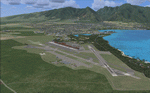
| Mauritius International Airport |

|
Images related to this file:
File Description:
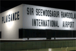
Mauritius International Airport for FSX. Featuring a totally new modelling of Sir Seewoosagur Ramgoolam (SSR) International airport. Gmax modelled terminals, maintenance, cargo hangars, VIP Aviation terminal, fire station and more as well as photoreal ground textures, building textures, fully customised SSR vehicles and apron objects. Also included is the entire island of Mauritius rebuilt with new coastlines, beaches, towns, rivers, landclass and waterclass.
| Filename: | Mauritius_International_Airport.zip |
| License: | Freeware, limited distribution |
| Added: | 1st April 2011, 05:18:06 |
| Downloads: | 28,723 |
| Author: | Max Kraus |
| Size: | 36 MB |
| Category: Flight Simulator 2004 - Aircraft Repaints, Textures and Modifications | |
| Gulfstream Int'l Airlines (Continental Connection) Beech 1900 D |
|
File Description:
2 Repaints of the Gulfstream Int'l Airlines(Continental connection),one is in "regular" scheme and one is updated "Grand Bahama Island" scheme for low polygon version Beechcraft 1900D Airliner by Henry Tomkiewicz. Features animated landing gear, flaps, and props.this model has 2798 polygons (ACM), 10 levels of detail (LODs), and is suitable for AI use. See readme file for more information.
| Filename: | Gulfstream_Intl_Airlines_Continental_Connection_Be.zip |
| License: | Freeware, limited distribution |
| Added: | 8th January 2005, 05:42:08 |
| Downloads: | 4,496 |
| Author: | Steve Tran / Henry Tomkiewicz |
| Size: | 277.06 KB |
| Category: Flight Simulator X - Scenery | |
| Skiathos |
|
Images related to this file:
File Description:

AS REAL AS IT GETS.
This is a highly detailed photorealistic scenery of the beautiful islands of Voreies Sporades including Skiathos, Skopelos, Alonisos, Peristera, Kyra Panagia, Skatzoura, Gioura kai Adelfi.
Default FSX airport of the island (LGSK) was corrected and repositioned to the exact location and the ELEVATION WAS CHANGED.
READ SKIATHOS.TEXT FOR IMPORTANT INFORMATION FOR THE INSTALLATION OF AIRPORT
ELEVATION CHANGE FILE.
| Filename: | Skiathos.zip |
| License: | Freeware |
| Added: | 27th June 2011, 00:50:25 |
| Downloads: | 7,960 |
| Author: | Angelo Tassoglou |
| Size: | 122.92 MB |
| Category: Prepar3D V1-4 - Scenery | |
| EGAR Rothera Research Station and Air Facility |
|
File Description:
This is scenery of the Rothera Research Station and airstrip located on Adelaide Island in Antarctica. Rothera is the main base of the British Antarctic Survey and is populated by app. 100 scientists and support personnel in summer, while 22 hardy personnel remain on the base during the winter months. Please see the Readme file for more information and installation instructions.
| Filename: | EGAR_Rothera_Research_Station_and_Air_Facility.zip |
| License: | Freeware |
| Added: | 22nd December 2020, 19:25:33 |
| Downloads: | 206 |
| Author: | David Midgett |
| Size: | 2.18 MB |
| Category: Flight Simulator X - Scenery | |
| Landclass for Maui |
|
Images related to this file:
File Description:
FSX Scenery--Landclass For Maui, Hawaii. This is a detailed landclass and scenery redesign of the entire Island of Maui. The changes that have been created will make for excellent VFR flying. Hundreds of objects have been added that reflect the real layout and scenery for this location. Maui's three airports have also been extensively modified to look like the real existing airports.
| Filename: | Landclass_for_Maui.zip |
| License: | Freeware |
| Added: | 5th April 2011, 07:41:07 |
| Downloads: | 4,109 |
| Author: | Charles Reid |
| Size: | 17.27 MB |
| Category: X-Plane - Missions | |
| HelicopterLighthouseMissionsVol42.zip |
|
File Description:
Eight lighthouse tours: Cape Navarin, Fourteen Foot Shoal, New Canal, Pilot Island, Punta Cumplida, Punta Orchilla, St.Davids, and Cheshkiy.These missions were programmed in Windows 10 (64bit)for FSX Acceleration and will also work in FSX Steam, P3DV3,V4,V5,and V6. However, several of these tours have specific requirements of Orbx scenery which is detailed in the .txt instructions.Photos of all the lites are included in each mission set. Once again, be sure to read the instructions in the .txt files. These missions have been thoroughly tested and should work as described. Due to large topographic differences in P3DV5 and V6, there will be peculiarities, but the missions should still work.Please note: There are four tours here that will not work with any version of P3D due to scenery incompatibilities. They are Fourteen Foot Shoal, New Canal, Pilot Island, and Cheshkiy Maintenance.
| Filename: | HelicopterLighthouseMissionsVol42zip.zip |
| License: | Freeware |
| Added: | 17th May 2025, 00:01:27 |
| Downloads: | 9 |
| Author: | Helomissionman |
| Size: | 96.91 MB |
| Category: Flight Simulator 2004 - Scenery | |
| Matheson Point CWMP in Nunavut, Canada |
|
Images related to this file:
File Description:
This was a DEW line I Station on the southeast shore of King William Island; the island is around 70 miles square and Gjoa Haven is also on the southeast corner, 20 miles to the south. The station was closed in 1963 and has now been totally dismantled and removed except for a fallen 300 feet communications tower. The runway is still there (mostly) and is around 3,360 feet of gravel 120' wide, aligned 146T/326T. There are no lights, signage, or windsock, or any building remaining. All of these DEW line stations are not particularly impressive or even interesting. However, you can bet that any pilot flying regularly in the north along the coast knows where all these runways are, in case one of them suddenly becomes his favourite in the whole world just after the sudden silence.
| Filename: | Matheson_Point_CWMP_in_Nunavut_Canada.zip |
| License: | Freeware, limited distribution |
| Added: | 22nd November 2012, 16:28:19 |
| Downloads: | 178 |
| Author: | Roger Wensley |
| Size: | 785.57 KB |
| Category: Orbiter - Spaceships | |
| Thunderbirds 1, 2 and 4 |
|
File Description:
Take off in Thunderbird2 with Thunderbird4 from Tracy-Island...First Press G to Lower Thunderbird2 onto the POD payload..Then engage 5% thrusters and taxi to the middle of the runway..Press B to brake..Press 0 on the numpad to engage Hover Thrusters, Once airbourne press CTRL and + on the numpad to engage main thrusters...Press J to jetason the Pod with Thunderbird4 in...Press F3 to switch to Pod4 and press G to open Pod Door..Press J to Jetson Thunderbird4..Launch Thunderbird1 from Tracy Island.Press K to operate Thunderbird1's Swingwing once you have Launched..Press F3 to Switch between Thunderbird 1 and the Pool..Press G to close and open the Pool...Now with Sounds (Needs OrbiterSound ver 2.5 or higher installed)..T1 & T2 DLL Based on the Vulcan.dll by David Henderson..The Island Pool Uses Vinkas Spacecraft.DLL(included).
| Filename: | Thunderbirds_1_2_and_4.zip |
| License: | Freeware |
| Added: | 16th October 2004, 14:37:10 |
| Downloads: | 1,074 |
| Author: | Kev Shanow |
| Size: | 2.69 MB |
| Category: Flight Simulator X - Scenery | |
| CYCD - Nanaimo |
|
File Description:
Nanaimo is one of the greatest city situated on the east side of Vancouver Island, only 20mn Hop from/to YVR - Vancouver Intl and less than 10mn from Victoria,The capital.
Enjoy your stop in Nanaimo while soaring this beautifull island!
Nanaimo has as well a harbour to welcome all seaplane that I will develop in a near future so stay tuned!! :)
I have placed a larger terminal as it is today, all maintenance hangar located north and south, Both closed taxiway,the large oval parking lot and of course, the tower control that FSX completely forgot! :0
The push back truck is on auto for the two left side parking spot.(the nearest to the tower)
Nanaimo only offers an NDB for the Rwy 16.
Hope this will make your stop-over more Fun!
Airport already available:
-CZBB Boundary Bay
| Filename: | CYCD__Nanaimo.zip |
| License: | Freeware |
| Added: | 7th March 2009, 12:46:30 |
| Downloads: | 2,537 |
| Author: | Daniel Louvet |
| Size: | 1.29 MB |
| Category: Flight Simulator 2004 - Miscellaneous Files | |
| Emma Field Sightseeing Tour Release III |
|
File Description:
Fly a VFR-tour in the area around Seattle, Washington. You will need some skills of bush-flying. Included in this package are a detailed tour-description, maps (one per stage), situation- and WX-files (also per stage). You will leave from Emma Field (KEWL) and visit the following airfields: Forks (S18), Sekiu (11S), Sequim Valley (W28), Orcas Island (KORS), Lynden (38W), Israels Farm (WA56), Stehekin State (6S9), Lake Wenatchee State (27W), Skykomish State (S88), Sky Harbor (S86), Bandera State (4W0), Easton State (KESW), Trout Lake (66WA), Mt.St.Helens Aero Ranch (WN10), Seaside Muni (56S), Westport (14S) and Cricket Field (4WA2), before you return to Emma Field.
This tour is based on the products Emma Field (Lago), GeoRender 5 (Lago), GeoRender 6 (Lago) and Orcas Island (FSAddon), but can also be flown without (one of) these. Enjoy.
| Filename: | Emma_Field_Sightseeing_Tour_Release_III.zip |
| License: | Freeware |
| Added: | 30th July 2004, 16:21:08 |
| Downloads: | 1,685 |
| Author: | Jaap van Hees |
| Size: | 5.84 MB |
© 2001-2026 AVSIM Online
All Rights Reserved
Privacy Policy |