
Where Flight Simulation Enthusiasts Gather from Around the World!
AVSIM Library - Search Results

| Category: Flight Simulator 2004 - Scenery | |
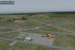
| The Bermudas Islands |

|
Images related to this file:
File Description:

The Bermudas islands are located in the middle Atlantic. Their main island is in the 32 15 71 N and 64 52 50 W.Is a very broken into fragments island that it is part of s cluster of 150 islands distributed in an area of 53 square kms
This archipielago like superior vertex together with Puerto Rico island and the city of Lauderade-Hollywood in Florida U.S.A. tey form the celebrates TRIANGLE OF BERMUDAS that in the time 50 ships and 20 airplanes have disappeared. Most of these disappareances they can be explained, other nr.
Nevertheless to the one West of the island and a near a carrier to 2000-3000
feet high approximately I have discovery some ships floating in the space.
Not you if they are part of the disappareances....But they are there.
Discover it your same one....
| Filename: | The_Bermudas_Islands.zip |
| License: | Freeware |
| Added: | 8th November 2010, 04:31:29 |
| Downloads: | 1,808 |
| Author: | Toni Agramont |
| Size: | 14 MB |
| Category: Flight Simulator X - Missions | |
| HAFB Fire Crew Extraction |
|
File Description:
(FSX Acceleration)- Fly from Hill AirForce Base around the Wasatch Front, Near Ogden Utah. Fire Crew, Commander and Pilot are in Immediate need of extraction. The Fire has blocked thier escape route and they need help fast. Fly the AugustaWestland EH101, USAF flavor to get the Crew Out. Drop the Crew off near the Ambulance. Help put out the fires in a Specially modified Goose(Use your Imagination). Fly under 150 Feet over the East side Fires to put them out. Turn back to the lake and Kiss the Water to simulate a Water pick up. Enjoy the company, two other gooses are trying to put out the West Side Fires. Entire mission is in a 17-mile radius. A reward is given after completion of putting out the Fires. All 4-goals need to be accomplished to get the Reward. Enjoy, Many Cheers Ed O........:-)
| Filename: | HAFB_Fire_Crew_Extraction.zip |
| License: | Freeware |
| Added: | 8th January 2008, 23:42:34 |
| Downloads: | 3,771 |
| Author: | Ed Olander |
| Size: | 8.99 MB |
| Category: Flight Simulator 2004 - Aircraft Repaints, Textures and Modifications | |
| Lockheed VC-121E "Columbine III" |
|
File Description:
The C-121 is the military version of the famed "Constellation" commercial transport. During WW II, the AAF purchased 22 early model Constellations which were designated C-69s, and between 1948 and 1955 the USAF ordered 150 C-121s for use as cargo and passenger carriers, executive transports and airborne early warning picket ships.
It's the only VC-121E built, was President Eisenhower's personal airplane between 1954 and 1961. Mrs. Eisenhower christened it "Columbine III" in honor of the official flower of Colorado, her adopted home state, in ceremonies on Nov. 24, 1954. "Columbine III" served as the Presidental aircraft until President Eisenhower left office in January 1961. It remained in service transporting government officials and visiting foreign dignitaries throughout the world until it was retired to the U.S. Air Force Museum in 1966.Textures only, requires original aircraft by Mike Stone http://www.pmstone.com/
| Filename: | Lockheed_VC121E_Columbine_III.zip |
| License: | Freeware |
| Added: | 26th July 2005, 20:00:33 |
| Downloads: | 543 |
| Author: | Jean-Jacques Parel |
| Size: | 154.7 KB |
| Category: Flight Simulator 2004 - Scenery | |
| Repost of Dryden Regional CYHD in Ontario Canada |
|
File Description:
This repost is first to deal with some lighting problems on the runways (though I still couldn't get rid of the taxiway lights that head off across the grass) and also to provide the right AFCAD file.
Dryden is in northwest Ontario on the shore of Wabigoon Lake. The airfield is some five miles northeast of the town. It has two runways, one 2,000 feet long and sand, the other 11/29 and 6,000 feet of asphalt 150 feet wide. There is a terminal building, a hangar for Thunder Airlines, and some GA hangars at and near the western apron, and in the Summer there is a flock of fire-fighting Canadair CL415 amphibs at the eastern apron together with the Ministry of Natural Resources Ontario fire fighting headquarters establishment, accomodation, and maintenance facilities. Among others Bearskin Airlines fly there, a wonderful punning name.
| Filename: | Repost_of_Dryden_Regional_CYHD_in_Ontario_Canada.zip |
| License: | Freeware |
| Added: | 15th February 2009, 15:34:49 |
| Downloads: | 595 |
| Author: | Roger Wensley |
| Size: | 4.51 MB |
| Category: Flight Simulator 2004 - Scenery | |
| Iles de la Madeleine CYGR in Quebec Canada |
|
Images related to this file:
File Description:
The Iles de la Madeleine are a group of spit islands linked by bridges in the Gulf of St Lawrence. They are east of New Brunswick, north of Cape Breton Island, west of the Island of Newfoundland, and south of the mainland coast of Quebec. On a southwest to northeast axis they are 40 miles in length and the airport CYGR is pretty much at the midpoint of the southern line of islands. Take a look at the overhead from FS9 to see what I mean. CYGR has two runways, one is aligned 08-26 and is just under 4,400 feet long and 150 feet wide with lighting and PAPI at both ends. The second is aligned 16-34 and is 3,600 feet long and 150 feet wide, without lights or PAPI. Both are asphalt. The apron is not huge, and a newish (in 2010) hangar was built with separate access to the 16-34 runway. There are daily flights by Air Canada and Pascan Aviation included in the AI. The AI also includes some boats and a ferry, and I first used these with my Dutch Harbor scenery, so if you have that already.... This scenery also includes Cindy Hook, a small boat harbour just 2 miles southwest of the airport, and the larger harbour at Cap aux Meules a further 3 miles away that accommodates the daily ferry trips, along with fishing boats etc. Also included here is a further addition to the Homer PAHO scenery in the shape of a boat that is included in the Homer Spit harbour. Just add the contents of the scenery folder to the Homer scenery folder of your Homer installation, and the texture folder contents to the Homer texture folder. This is hopefully the last PAHO addition, and again apologies. If you find an error email me please, and note that my email address has been changed to rogwens at Gmail dot com.
| Filename: | Iles_de_la_Madeleine_CYGR_in_Quebec_Canada.zip |
| License: | Freeware, limited distribution |
| Added: | 28th July 2021, 17:02:18 |
| Downloads: | 187 |
| Author: | Roger Wensley |
| Size: | 26.7 MB |
| Category: X-Plane - Scenery | |
| KAVO - Avon Park Executive Airport Florida |
|
Images related to this file:
File Description:
Avon Park Executive Airport, Airport Code KAVO, is located in the center of the Florida peninsula. It is within 80 miles of several major Florida cities and International Airports including Tampa International and Orlando International. Miami International is located about 150 miles SSE. Although used primarily by local businesses, it has repair facilities for planes flown in for that purpose. In addition, it is used as a temporary base for people attending the 12 Hours of Sebring Gran Prix auto race as well as air shows held both at Sebring Regional and Lakeland Linder airports.
The Terminal/Office building was created by me in Google Sketchup and contains nothing from any other source. The windows are actual photos taken of the building at the Avon Park Airport. I obtained permission to use those photos from the Avon Park Executive Airport director. You may use all or any part of this upload for any purpose that is legal.
OpenSceneryX required.
| Filename: | KAVO__Avon_Park_Executive_Airport_Florida.zip |
| License: | Freeware |
| Added: | 29th January 2013, 00:36:32 |
| Downloads: | 138 |
| Author: | Frank Watson |
| Size: | 6.91 MB |
| Category: Flight Simulator 2004 - Scenery | |
| Maniwaki CYMW in Ontario Canada |
|
Images related to this file:
File Description:
Maniwaki airfield is seven miles south of the town of Maniwaki and some 60 miles north of Ottawa, up the Gatineau River. There is a generous 5,000 feet of runway 03/21 that is 150 feet wide and in bad condition, so bad that there are now almost no markings of any sort (even a centre line, the apron has more paint than the runway!) and the whole lot is going to be redone next summer. The apron is large, and in the summer accomodates two Bombardier CL 415 fire fighting amphibians, which is why there is a large access platform loitering on the apron. There are only five hangars on the field with another one tucked into the trees behind a house. The hangars and the office/cafe building have been modelled specifically for this field. There are further buildings to the north which are not actually on the airfield and which house fire department personnel.
| Filename: | Maniwaki_CYMW_in_Ontario_Canada.zip |
| License: | Freeware, limited distribution |
| Added: | 14th February 2010, 23:12:27 |
| Downloads: | 504 |
| Author: | Roger Wensley |
| Size: | 4.56 MB |
| Category: Flight Simulator X - Scenery | |
| Avon Park Executive Airport Florida |
|
Images related to this file:
File Description:
Avon Park Executive Airport, Airport Code KAVO, is located in the
center of the Florida peninsula. It is within 80 miles of several major
Florida cities and International Airports including Tampa International
and Orlando International. Miami International is located about 150
miles SSE. Although used primarily by local businesses, it has repair
facilities for planes flown in for that purpose. In addition, it is
used as a temporary base for people attending the 12 Hours of Sebring
Gran Prix auto race as well as air shows held both at Sebring Regional
and Lakeland Linder airports.
The Terminal/Office building was created by me in Google Sketchup and
contains nothing from any other source. The windows are actual photos
taken of the building at the Avon Park Airport. I obtained permission
to use those photos from the Avon Park Executive Airport director. You
may use all or any part of this upload for any purpose that is legal.
| Filename: | Avon_Park_Executive_Airport_Florida.zip |
| License: | Freeware |
| Added: | 21st January 2013, 00:39:01 |
| Downloads: | 803 |
| Author: | Frank Watson |
| Size: | 2.08 MB |
| Category: Flight Simulator 2004 - Scenery | |
| CWCP - Cape Parry - Northwest Territories, Canada |
|
Images related to this file:
File Description:
This is a DEW line Main Station on the shore of the Canadian mainland at the far northern tip of Cape Parry. It is 60 miles north of Paulatuk, which is at the base of the Parry Peninsula, and 120 miles south of Sachs Harbour on Banks Island. The station ceased operations in 1989 and a North Warning System automated station was opened in the same year; the NWS station is not shown in this scenery as I have no information regarding it's location or layout. The runway is just over 5,000 feet of gravel 150 feet wide, aligned 037T at an elevation of 119 feet ASL. There is a large apron with a large hangar and a small shelter building for passengers. There are of course no lights, signage, or windsock. The station is up on the hill at 210 feet ASL. This is one of the more interesting stations in terms of size and complexity.
| Filename: | CWCP__Cape_Parry__Northwest_Territories_Canada.zip |
| License: | Freeware, limited distribution |
| Added: | 25th December 2012, 19:07:24 |
| Downloads: | 302 |
| Author: | Roger Wensley |
| Size: | 1.61 MB |
| Category: Flight Simulator 2004 - Scenery | |
| Clinton Point CWCP, Horton River CWHR & Keats Point CWKP; DEW sites in Northwest Territories, Canada |
|
Images related to this file:
File Description:
These are three DEW line sites in northern mainland Canada, to the east of Tuktoyaktuk.
Clinton Point is almost 300 miles east of Tuktoyaktuk and on the Northwest Territories and Nunavut border. It is the site of a closed DEW station (closed in 1993) and all the buildings have been removed, unlike many other sites where buildings are still almost complete. The roads and the gravel runway down by the beach are still there.
Horton River is 150 miles east of Tuktoyaktuk, up on higher land above the cliffs at around 500 feet ASL. The NWS (North Warning System) replaced the I site which was there previously and which ceased operations in 1963. The NWS is serviced by helicopter from a barge 400 yards away on the beach.
Keats Point is 270 miles east of Tuktoyaktuk, 7 miles from the coast but significantly close to a lake, which was probably used for float plane delivery in the summer (or ski plane delivery in the winter) of NWS station elements during construction.
| Filename: | Clinton_Point_CWCP_Horton_River_CWHR__Keats_Point_.zip |
| License: | Freeware, limited distribution |
| Added: | 17th July 2012, 18:57:08 |
| Downloads: | 278 |
| Author: | Roger Wensley |
| Size: | 2.07 MB |
© 2001-2026 AVSIM Online
All Rights Reserved
Privacy Policy |