
Where Flight Simulation Enthusiasts Gather from Around the World!
AVSIM Library - Search Results

| Category: Flight Simulator 2004 - Original Aircraft | |
| Avro Lancastrian II |

|
File Description:
A close derivative of the war-time Lancaster bomber, the Lancastrian was
fitted with streamlined nose and tail cones. Lancastrians were used as
long-range freighters, VIP transports, and jet engine test beds by the
RAF, as fast long-range airliners and mailplanes by Trans Canada Air
Lines, BOAC, BSAA, QUANTAS, and Alitalia, and as tankers by Flight
Refuelling Ltd. Charter operators were Skyways and Silver City.
Eighty-two aircraft were build, but most of them had vanished in
scrapyards by the early nineteen-fifties. In the immediate post-war
years, TCA offered twice-weekly Lancastrian flights from Dorval, Canada,
to Prestwick and London, while BOAC and BSAA (under chief pilot D.C.T.
Bennett) operated flights to Australia and South America, all based on a
rather uneconomical ratio of five crew to up to fourteen passengers. The
outbound leg from Hurn to Learmouth, Australia, took three days and well
over fifty hours flying time, with Lydda, Karachi, and Ceylon serving as
staging posts. BSAA's London to Buenos Aires flight took 56 hours.
Either way, one needs to have plenty of time on one's hands to recreate
these epic journeys. Gmax exterior model and textures by Manfred Jahn,
FDE and 2D panel by Paul Edwards (based on a panel by Phil Perrott of
Alphasim). The three texture sets included represent VM734 of 246
Squadron RAF, G-AGLY ("Norfolk") of BOAC, and G-AKFG of Flight
Refuelling Ltd.
| Filename: | Avro_Lancastrian_II.zip |
| License: | Freeware |
| Added: | 20th May 2007, 10:45:54 |
| Downloads: | 6,653 |
| Author: | Manfred Jahn and Paul Edwards |
| Size: | 5.23 MB |
| Category: Flight Simulator 2004 - Scenery | |
| Clinton Point CWCP, Horton River CWHR & Keats Point CWKP; DEW sites in Northwest Territories, Canada |
|
Images related to this file:
File Description:
These are three DEW line sites in northern mainland Canada, to the east of Tuktoyaktuk.
Clinton Point is almost 300 miles east of Tuktoyaktuk and on the Northwest Territories and Nunavut border. It is the site of a closed DEW station (closed in 1993) and all the buildings have been removed, unlike many other sites where buildings are still almost complete. The roads and the gravel runway down by the beach are still there.
Horton River is 150 miles east of Tuktoyaktuk, up on higher land above the cliffs at around 500 feet ASL. The NWS (North Warning System) replaced the I site which was there previously and which ceased operations in 1963. The NWS is serviced by helicopter from a barge 400 yards away on the beach.
Keats Point is 270 miles east of Tuktoyaktuk, 7 miles from the coast but significantly close to a lake, which was probably used for float plane delivery in the summer (or ski plane delivery in the winter) of NWS station elements during construction.
| Filename: | Clinton_Point_CWCP_Horton_River_CWHR__Keats_Point_.zip |
| License: | Freeware, limited distribution |
| Added: | 17th July 2012, 18:57:08 |
| Downloads: | 282 |
| Author: | Roger Wensley |
| Size: | 2.07 MB |
| Category: Flight Simulator 2004 - AFCAD Files | |
| Calgary International Airport, Calgary, Alberta, Canada (CYYC/YYC) CanUK - Scenery (Fix for FSNav and FSCommander) |
|
File Description:
This AFCAD2 file will correctly display taxiways and parking areas for CYYC by CanUk
| Filename: | Calgary_International_Airport_Calgary_Alberta_Cana.zip |
| License: | Freeware |
| Added: | 11th April 2007, 12:20:41 |
| Downloads: | 1,659 |
| Author: | CanUk Scenery Adam Bentley and David Madge |
| Size: | 11.8 KB |
| Category: Flight Simulator 2004 - AI Aircraft | |
| Cirrus Airlines De Havilland Canada DHC-8-300 Dash 8 'D-BIER' 50 Jahre Saarland |
|
File Description:
Repaint of the PAI Dahs8-300. Paint of the Cirrus Airlines Special Livery "50 Jahre Saarland" D-BIER. Use with the PAI-models available on Projektai.com. For more informations about the actual flightplan and other repaints for the flightplan, please visit http://worldoftraffic.de.ki/
| Filename: | Cirrus_Airlines_De_Havilland_Canada_DHC8300_Dash_8.zip |
| License: | Freeware |
| Added: | 12th June 2007, 22:36:07 |
| Downloads: | 578 |
| Author: | Martin Schumacher |
| Size: | 242.09 KB |
| Category: Flight Simulator 2004 - Original Aircraft | |
| Australian Customs Service De Havilland Canada DHC-8-200 Dash 8 / 8Q (All New Design) |
|
File Description:
FS2004 PAD Dehavilland Dash8-Q202. A modified twin turboprop regional airliner. Australian Customs Service,
operated by Surveillance Australia. An all new FSDS2.24 design with 2D panel, Dynamic VC, and Custom Sound. In addition, a custom TCAS (Traffic Collision Avoidance System), a complete Ground Handling module with push back and taxi speed control and the latest version GPWS (Ground Proximity Warning System) is included. The visual model features an opening airstair with detailed cabin interior, operating lift dump and roll control spoilers, passenger wing and cabin views, and high definition reflective textures. A comprehensive set of html documents (Check List & Ref List) are included for in-flight information. A separate Panel_Docs folder accompanies this release with panel and systems help files and pilot's notes and more.
| Filename: | Australian_Customs_Service_De_Havilland_Canada_DHC.zip |
| License: | Freeware, limited distribution |
| Added: | 19th May 2005, 04:56:53 |
| Downloads: | 7,997 |
| Author: | Jean-Pierre Brisard, Barry Blaisdell, Bob May - Premier Aircraft Design |
| Size: | 21.48 MB |
| Category: Flight Simulator 2004 - Scenery | |
| KIAH - Houston Intercontinental Airport v3.0 |
|
File Description:
Flightlevel390 is proud to present to you KIAH-Houston's George Bush Intercontinental Airport version 3.0.This scenery was created using EZ-Scenery object placer & Flightones' Instant Scenery.This scenery WILL NOT work in FS X.This will work with Default FS9 terrain,although it is optimized for use with ultimate terrain...This will be the final project under the FL390 brandname,all projects hereafter will be with BSMP...
Includes the Main terminals,Continental Maintenence Base,FedEx cargo ramp,UPS cargo ramp,City cargo ramp,fuel farm by 15R,CFR building further down 15R,CFR Building along Rwy 9-27 taxiway,FBOs on both sides of the 33s,including the big Landmark Aviation FBO,static ground equipment & some custom made signs.Also includes full ramp night lighting,aircraft gate outline markings at each gate.
This version adds some more stuff and fixing some stuff that was noted in previous versions.This also fixes the blurries that some people had reported.
Features a very good and super accurate AFCAD file and decent rendition of the real airport layout.***
Most of the objects in this scenery are all default with some of our own custom made stuff and some objects from some 3rd party EZ Object Libraries and RWY12 Object Libraries.
***You will need to download the EZ-Scenery & RWY12 Object Libraries which can be had at avsim,flightsim.com and our own website available as single downloads instead of multiple seperate downloads.I also recomend that you install our recently released EZ-Object Library Installer which is available at flightsim.com and our own website in the downloads section.File name on flightsim.com is ( EZOLIv33.zip )....
Downloading the installer will ensure that you will have all of the fixed default textures from Sid Schwartz's default libraries....As always...Enjoy!!
| Filename: | KIAH__Houston_Intercontinental_Airport_v30.zip |
| License: | Freeware |
| Added: | 15th June 2008, 17:39:45 |
| Downloads: | 8,412 |
| Author: | Joe DeGregorio |
| Size: | 3.08 MB |
| Category: Prepar3D V5 - Scenery | |
| Victoria Falls Bridge – Southern Africa |
|
Images related to this file:
File Description:
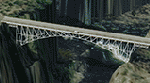
The Victoria falls bridge is located just below the spectacular Victoria water falls in the Zambezi River linking Zimbabwe and Zambia. The steel bridge was completed in 1905 and spans the 200m wide and 128 m wide gorge just below the 1708 m wide falls. This area seems to be a bit neglected in the sim despite the latest add-ons so I decided to spruce it up a little by adding a spray effect for the falls and making some changes to the surface to try to show the waterfall.
I used the P3D 5.3 SDK and tested it in P3D V5.3 using the ORBX Africa LC and Pilots NG2020 mesh products The falls and bridge is 10nm to the north of FVFA in Zimbabwe or 165 degrees from FLNH if you want to approach it from the Zambia side.
| Filename: | Victoria_Falls_Bridge___Southern_Africa.zip |
| License: | Freeware |
| Added: | 1st February 2022, 01:06:27 |
| Downloads: | 66 |
| Author: | Johan Pienaar |
| Size: | 12.78 MB |
| Category: Flight Simulator 2004 - Scenery | |
| EPGD 2008 - Gdansk Lech Walesa Airport, Poland |
|
Images related to this file:
File Description:

Gdansk Lech Walesa Airport (EPGD) is an international airport located in Gdansk, Poland, not far from the city centers of the Tricity metropolitan area: Gdansk (6.25 miles/10 km), Sopot (6.25 miles/10 km) and Gdynia (14.4 miles/23 km). The airport is named after Lech Walesa, the former Polish president. On the outside wall of the terminal building one can see the logo of the airport, which is Lech Walesa's actual signature, a stylized "W".
EPGD 2008 is the first Polish scenery in this quality. Main features of the scenery are:
-Airport ground high resolution textures - (five seasons + night textures);
-Highly detailed 3D objects, all photo textured;
-Animation vehicles ground services;
-Detailed autogen and photorealistic trees;
-Detail mesh.
For more details please look at the README file attached to the scenery file.
| Filename: | EPGD_2008__Gdansk_Lech_Walesa_Airport_Poland.zip |
| License: | Freeware |
| Added: | 18th May 2010, 10:37:46 |
| Downloads: | 25,749 |
| Author: | Kuba Paczek |
| Size: | 24.06 MB |
| Category: X-Plane - Scenery | |
| WXAR Susi Air Armopa Road Airstrip v1.0.0 |
|
Images related to this file:
File Description:

This is an X-Plane 11 scenery for Armopa Road Airstrip (WXAR) in the Armopa, Papua, Indonesia. This is a fictitious airfield, located in an active road. This fictitious airfield may serve as a road challenge while flying the airstrips in Papua, as one of the destinations for "PT ASI Pujiastuti Aviation", operating as Susi Air, an Indonesia airlines established in late 2004 by Mrs. Susi Pudjiastuti. This scenery was tested and is operational (as of January 19, 2017) in "X-Plane 11 Public Beta #6 64 bit", Windows 10 Home. It was also tested and is partially operational (as of January 19, 2017) in "X-Plane 10.51 64 bit", Windows 10 Home. The issue with XP10 is the mesh again: there is no road in XP10, and no traffic, while the road and the traffic is there in XP11.
| Filename: | WXAR_Susi_Air_Armopa_Road_Airstrip_v100.zip |
| License: | Freeware |
| Added: | 20th January 2017, 07:11:16 |
| Downloads: | 53 |
| Author: | Rui Mesquita |
| Size: | 2.06 MB |
| Category: Prepar3D V1-4 - Scenery | |
| Grise Fiord Airport (CYGZ) N76.25.34 W82.54.36 |
|
File Description:
Grise Fiord Airport (CYGZ) N76.25.34 W82.54.36 is located in the Qikiqtaaluk Region of the territory of Nunavut, and is one of the northernmost inhabited settlements of Canada and the whole world. The scenario shows the airport infrastructure and the small town not far from the airport. This scenario goes to fill the absence of scenarios towards the North Pole. The airport is open only in the mei that go from August to October where it is practically possible to land considering also the proximity of mountains remains one of the most difficult and dangerous airports.
Within the downloaded package you will find readme files for scenery installation. Good fly VFR. Pasquale Marrulli.
| Filename: | Grise_Fiord_Airport_CYGZ_N762534_W825436.zip |
| License: | Freeware |
| Added: | 30th December 2017, 19:14:28 |
| Downloads: | 149 |
| Author: | Pasquale Marrulli |
| Size: | 2.97 KB |


© 2001-2026 AVSIM Online
All Rights Reserved
Privacy Policy |